Milton, Washington

Last updated

Milton, Washington
Milton, WA city hall.jpg
City hall
Nickname: 
Mill Town
Pierce County Washington Incorporated and Unincorporated areas Milton Highlighted.svg
Location of Milton, Washington
Coordinates: 47°14′54″N122°19′3″W / 47.24833°N 122.31750°W / 47.24833; -122.31750
CountryUnited States
State Washington
Counties Pierce, King
Government
  Type Mayor–council [1]
   Mayor Shanna Styron Sherrell [2]
Area
[3]
  Total2.82 sq mi (7.30 km2)
  Land2.78 sq mi (7.20 km2)
  Water0.04 sq mi (0.10 km2)
Elevation
305 ft (93 m)
Population
 (2020) [4]
  Total8,697
  Density2,985.25/sq mi (1,152.76/km2)
Time zone UTC-8 (Pacific (PST))
  Summer (DST) UTC-7 (PDT)
ZIP code
98354
Area code 253
FIPS code 53-46020
GNIS feature ID1512467 [5]
Website cityofmilton.net

Milton is a city in King and Pierce counties in the U.S. state of Washington. The population was 8,697 at the time of the 2020 census. [4] Milton borders the larger but newer town of Edgewood.

Contents

Geography

Milton is located in northern Pierce County and southern King County at 47°14′54″N122°19′3″W / 47.24833°N 122.31750°W / 47.24833; -122.31750 (47.248208, -122.317376). [6]

The Milton and Edgewood areas are known informally as North Hill. This contrasts with the South Hill area on the opposite side of the Puyallup River valley.

According to the United States Census Bureau, the city has a total area of 2.55 square miles (6.60 km2), of which 2.51 square miles (6.50 km2) are land and 0.04 square miles (0.10 km2) are water. [7]

Climate

This region experiences warm (but not hot) and dry summers, with no average monthly temperatures above 71.6 °F (22 °C). According to the Köppen Climate Classification system, Milton has a warm-summer Mediterranean climate, abbreviated "Csb" on climate maps. [8]

Demographics

Historical population
CensusPop.Note
1910 448
1920 4848.0%
1930 55915.5%
1940 67120.0%
1950 1,374104.8%
1960 2,21861.4%
1970 2,60717.5%
1980 3,16221.3%
1990 4,99558.0%
2000 5,79516.0%
2010 6,96820.2%
2020 8,69724.8%
U.S. Decennial Census [9]
2020 Census [4]

2020 census

As of the 2020 census, there were 8,697 people, and 3,288 families living in the city. [4] The median age in Milton was 37.3 years old. The population density was 3,128.4 inhabitants per square mile. [10] The racial makeup of the city was 77.5% White (6,086 people), 1.3% African American (352), 0.8% Native American (112), 7.8% Asian (575), 1.2% Pacific Islander (187), and 10.2% from two or more races (994). Those of Hispanic or Latino origin made up 11.2% (995). [10] [4]

The ancestry of Milton was 15.6% German, 9.5% English, 8.2% Irish, 6.4% Norwegian, 4.2% Scottish, 2.0% French, 1.9% Polish, and 0.2% Sub-Saharan African. [4]

2010 census

As of the 2010 census, [11] there were 6,968 people, 2,901 households, and 1,834 families living in the city. The population density was 2,776.1 inhabitants per square mile (1,071.9/km2). There were 3,081 housing units at an average density of 1,227.5 per square mile (473.9/km2). The racial makeup of the city was 82.9% White, 3.1% African American, 1.2% Native American, 5.1% Asian, 0.8% Pacific Islander, 1.7% from other races, and 5.2% from two or more races. Hispanic or Latino of any race were 5.4% of the population.

There were 2,901 households, of which 33.1% had children under the age of 18 living with them, 44.5% were married couples living together, 13.5% had a female householder with no husband present, 5.2% had a male householder with no wife present, and 36.8% were non-families. 28.3% of all households were made up of individuals, and 10.3% had someone living alone who was 65 years of age or older. The average household size was 2.40 and the average family size was 2.95.

The median age in the city was 36.7 years. 23.4% of residents were under the age of 18; 9.3% were between the ages of 18 and 24; 28.9% were from 25 to 44; 26.5% were from 45 to 64; and 12% were 65 years of age or older. The gender makeup of the city was 47.7% male and 52.3% female.

2000 census

As of the 2000 census, there were 5,795 people, 2,390 households, and 1,563 families living in the city. The population density was 2,291.3 people per square mile (884.4/km2). There were 2,503 housing units at an average density of 989.7 per square mile (382.0/km2). The racial makeup of the city was 90.34% White, 1.14% African American, 1.17% Native American, 2.83% Asian, 0.28% Pacific Islander, 0.79% from other races, and 3.45% from two or more races. Hispanic or Latino of any race were 3.55% of the population.

There were 2,390 households, out of which 31.2% had children under the age of 18 living with them, 49.7% were married couples living together, 11.3% had a female householder with no husband present, and 34.6% were non-families. 28.0% of all households were made up of individuals, and 10.1% had someone living alone who was 65 years of age or older. The average household size was 2.39 and the average family size was 2.92.

In the city, the population was spread out, with 24.8% under the age of 18, 7.3% from 18 to 24, 31.7% from 25 to 44, 22.3% from 45 to 64, and 13.9% who were 65 years of age or older. The median age was 38 years. For every 100 females, there were 93.6 males. For every 100 women age 18 and over, there were 91.5 men.

The median income for a household in the city was $48,166, and the median income for a family was $64,105. Males had a median income of $41,508 versus $30,111 for females. The per capita income for the city was $22,400. About 4.8% of families and 8.0% of the population were below the poverty line, including 12.2% of those under age 18 and 7.4% of those age 65 or over.

Education

Most of Milton, including all of the Pierce County portion, is served by Fife Public Schools. [12] Other parts of the King County portion are in the Federal Way School District. [13]

Notable people

See also

Related Research Articles

<span class="mw-page-title-main">Moulton, Iowa</span> City in Iowa, United States

Moulton is a city in Appanoose County, Iowa, United States. The population was 607 at the time of the 2020 census.

<span class="mw-page-title-main">Rembrandt, Iowa</span> City in Iowa, United States

Rembrandt is a city in Buena Vista County, Iowa, United States. The population was 209 at the time of the 2020 census.

<span class="mw-page-title-main">Edgewood, Iowa</span> City in Iowa, United States

Edgewood is a city in Clayton and Delaware counties in the U.S. state of Iowa. Highway 3, which runs through the center of town, is the dividing line between the two counties. The Edgewood post office was established in 1852 on the Clayton side of the town. Edgewood was formally incorporated in 1892, although it had a functioning council for some time before that date. The population was 909 at the time of the 2020 census, down from 923 in 2000.

<span class="mw-page-title-main">Libertyville, Iowa</span> City in Iowa, United States

Libertyville is a city in Jefferson County, Iowa, United States. The population was 274 at the time of the 2020 census. It was platted in 1845.

<span class="mw-page-title-main">Elberon, Iowa</span> City in Iowa, United States

Elberon is a city in Tama County, Iowa, United States. The population was 184 at the time of the 2020 census.

<span class="mw-page-title-main">Hope, Kansas</span> City in Dickinson County, Kansas

Hope is a city in southern Dickinson County, Kansas, United States. As of the 2020 census, the population of the city was 317.

<span class="mw-page-title-main">Backus, Minnesota</span> City in Minnesota, United States

Backus is a city in Cass County, Minnesota, United States. The population was 262 at the 2020 census. It is part of the Brainerd Micropolitan Statistical Area.

<span class="mw-page-title-main">Fountain, Minnesota</span> City in Minnesota, United States

Fountain is a city in Fillmore County, Minnesota, United States. The population was 410 at the 2010 census. Fountain is the western terminus of the Root River segment of the Root River State Trail. Local attractions include the Fillmore County History Center.

<span class="mw-page-title-main">Henning, Minnesota</span> City in Minnesota, United States

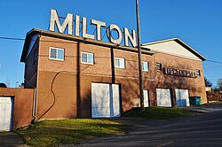
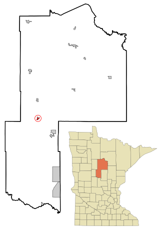
Henning is a city in Otter Tail County, Minnesota, United States. The population was 854 at the 2020 census.

<span class="mw-page-title-main">Vergas, Minnesota</span> City in Minnesota, United States

Vergas is a city in northern Otter Tail County, Minnesota, United States. The population was 348 at the 2020 census.

<span class="mw-page-title-main">Rock Creek, Minnesota</span> City in Minnesota, United States

Rock Creek is a city in Pine County, Minnesota, United States. The population was 1,628 at the 2010 census. Portions of the Mille Lacs Indian Reservation are located within Rock Creek.

<span class="mw-page-title-main">Leonidas, Minnesota</span> City in Minnesota, United States

Leonidas is a city in Saint Louis County, Minnesota, United States. The population was 50 at the 2020 census.

<span class="mw-page-title-main">Pierce City, Missouri</span> City in Missouri, United States

Pierce City, formerly Peirce City, is a city in southwest Lawrence and northwest Barry counties, in southwest Missouri, United States. The population was 1,292 at the 2010 census. In 2010, the town annexed property along Route 97 into Barry County to a point just north of U.S. Route 60. It was estimated to have a population of 1,309 by the City of Pierce City as of July 1, 2019.

<span class="mw-page-title-main">Crystal Lake Park, Missouri</span> City in Missouri, United States

Crystal Lake Park is a Missouri Class 4 city in St. Louis County, Missouri, United States. The population was 508 at the 2020 census.

<span class="mw-page-title-main">Pierce, Nebraska</span> City in Nebraska, United States

Pierce is a city in and county seat of Pierce County, Nebraska, United States. The population was 1,767 at the 2010 census.

<span class="mw-page-title-main">Glen Dale, West Virginia</span> Town in West Virginia

Glen Dale is a city in Marshall County, West Virginia, United States, along the Ohio River. It is part of the Wheeling, West Virginia Metropolitan Statistical Area. The population was 1,514 at the 2020 census. Glen Dale was incorporated in 1924. It is in the northwest part of the county, which is above the Mason–Dixon line and forms the base of the Northern Panhandle of West Virginia.

<span class="mw-page-title-main">Pennsboro, West Virginia</span> City in West Virginia, United States

Pennsboro is a city in Ritchie County, West Virginia, United States. The population was 1,050 at the 2020 census. The city is located at the junction of U.S. Route 50 and West Virginia Route 74; the North Bend Rail Trail also passes through the city.

<span class="mw-page-title-main">Vienna, West Virginia</span> City in West Virginia, United States

Vienna is a city in Wood County, West Virginia, United States, situated along the Ohio River. The population was 10,676 at the 2020 census. It is the second-largest city in the Parkersburg–Vienna metropolitan area.

<span class="mw-page-title-main">Windsor, Missouri</span> City in Missouri, United States

Windsor is a city in Henry and Pettis counties, Missouri, United States. The population was 2,901 at the 2010 census.

<span class="mw-page-title-main">Black Earth, Wisconsin</span> Village in Wisconsin, United States

Black Earth is a village in Dane County, Wisconsin, United States. The population was 1,338 at the 2010 census. The village is located within the Town of Black Earth. It is part of the Madison Metropolitan Statistical Area.

References

  1. "Mayor & Council". City of Milton. Retrieved March 28, 2022.
  2. "Mayor". City of Milton. Retrieved March 28, 2022.
  3. "2019 U.S. Gazetteer Files". United States Census Bureau. Retrieved August 7, 2020.
  4. 1 2 3 4 5 6 "2020 Census Redistricting Data (Public Law 94-171) Summary File". American FactFinder. United States Census Bureau . Retrieved May 16, 2022.
  5. "Milton". Geographic Names Information System . United States Geological Survey, United States Department of the Interior.
  6. "US Gazetteer files: 2010, 2000, and 1990". United States Census Bureau. February 12, 2011. Retrieved April 23, 2011.
  7. "US Gazetteer files 2010". United States Census Bureau. Archived from the original on January 25, 2012. Retrieved December 19, 2012.
  8. Climate Summary for Milton, Washington
  9. United States Census Bureau. "Census of Population and Housing" . Retrieved July 25, 2013.
  10. 1 2 "U.S. Census Bureau QuickFacts: Milton city, Washington". www.census.gov. Retrieved May 8, 2023.
  11. "U.S. Census website". United States Census Bureau . Retrieved December 19, 2012.
  12. U.S. Census Bureau Geography Division (December 23, 2009). 2020 Census – School District Reference Map: Pierce County, WA (PDF) (Map). 1:80,000. U.S. Census Bureau. p. 2. Retrieved August 4, 2022.
  13. U.S. Census Bureau Geography Division (December 21, 2020). 2020 Census – School District Reference Map: King County, WA (PDF) (Map). 1:80,000. U.S. Census Bureau. p. 4. Retrieved August 4, 2022.
  14. Maynard, Steve (December 6, 2010). "Milton mayor to resign, move on to Legislature". The Olympian . Retrieved October 10, 2021.
  15. "K. H. Simmons, Bonney Lake ex-mayor, dies". The News Tribune . December 30, 1981. p. B14. Retrieved October 10, 2021 via Newspapers.com.