East Renton Highlands, Washington

Last updated

East Renton Highlands, Washington
King County Washington Incorporated and Unincorporated areas East Renton Highlands Highlighted.svg
Location of East Renton Highlands, Washington
Coordinates: 47°28′52″N122°07′24″W / 47.48111°N 122.12333°W / 47.48111; -122.12333
CountryUnited States
State Washington
County King
Area
  Total
11.4 sq mi (29.5 km2)
  Land11.3 sq mi (29.3 km2)
  Water0.08 sq mi (0.2 km2)
Elevation
[1]
545 ft (166 m)
Population
 (2020) [2]
  Total
11,937
  Density984/sq mi (380.0/km2)
Time zone UTC-8 (PST)
  Summer (DST) UTC-7 (PDT)
FIPS code 53-19857 [3]
GNIS feature ID2408034 [1]

East Renton Highlands is a census-designated place (CDP) in King County, Washington, United States, located between Issaquah and Renton. The population was 11,937 at the 2020 census. [2]

Contents

History

In 1996, the city of Renton proposed an annexation of the Maplewood Heights area, part of the plateau's western edge, but it was rejected by voters. [4] A competing proposal to create a new city named Briarwood was also rejected by voters in a March 1998 election. [5]

East Renton Highlands is part of the potential annexation area (PAA) [6] of Renton, but in February 2007 voters defeated a 1,475-acre (5.97 km2) annexation proposal 3 to 1. In January 2008, the Renton City Council accepted a petition, using the 60% Direct Method, for the proposed Liberty Annexation: 193 acres (0.78 km2) located in the vicinity of 156th Avenue SE, SE 144th Street, and SE 134th Street. [7]

Geography

East Renton Highlands is bordered to the west by the city of Renton, to the east by the Mirrormont CDP, and to the southeast by the Hobart CDP. To the south is the Cedar River. East Renton Highlands is 17 miles (27 km) southeast of downtown Seattle.

According to the United States Census Bureau, the CDP has a total area of 11.4 square miles (29.5 km2), of which 11.3 square miles (29.3 km2) are land and 0.1 square miles (0.2 km2), or 0.57%, are water.

Demographics

Historical population
CensusPop.Note
1980 12,033
1990 13,2189.8%
2000 13,2640.3%
2010 11,140−16.0%
2020 11,9377.2%
U.S. Decennial Census [8]
2020 Census [2]

2000 census

As of the census of 2000, there were 13,264 people, 4,668 households, and 3,743 families residing in the CDP. The population density was 1,055.1 people per square mile (407.4/km2). There were 4,760 housing units at an average density of 378.6/sq mi (146.2/km2). The racial makeup of the CDP was 90.76% White, 1.46% African American, 0.86% Native American, 3.10% Asian, 0.11% Pacific Islander, 1.01% from other races, and 2.71% from two or more races. Hispanic or Latino of any race were 3.43% of the population.

There were 4,668 households, out of which 37.9% had children under the age of 18 living with them, 68.3% were married couples living together, 8.1% had a female householder with no husband present, and 19.8% were non-families. 14.4% of all households were made up of individuals, and 3.7% had someone living alone who was 65 years of age or older. The average household size was 2.83 and the average family size was 3.12.

In the CDP the population was spread out, with 26.7% under the age of 18, 6.5% from 18 to 24, 30.6% from 25 to 44, 28.4% from 45 to 64, and 7.8% who were 65 years of age or older. The median age was 38 years. For every 100 females there were 104.0 males. For every 100 females age 18 and over, there were 101.5 males.

The median income for a household in the CDP was $65,268, and the median income for a family was $65,855. Males had a median income of $50,149 versus $33,917 for females. The per capita income for the CDP was $27,089. About 3.2% of families and 4.5% of the population were below the poverty line, including 3.1% of those under age 18 and 6.1% of those age 65 or over.

Education

Most of the community is in the Issaquah School District. A portion is in the Renton School District, and another portion is in the Tahoma School District. [9]

Related Research Articles

<span class="mw-page-title-main">Pinewood, Florida</span> Census-designated place in Florida

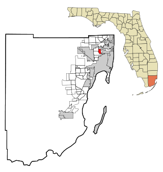
Pinewood is an unincorporated community and census-designated place (CDP) in Miami-Dade County, Florida, United States. It is part of the Miami metropolitan area of South Florida. The population was 17,246 at the 2020 census.

<span class="mw-page-title-main">Briarwood, Kentucky</span> City in Kentucky, United States

Briarwood is a home rule-class city in Jefferson County, Kentucky, United States. The population was 435 at the 2010 census, down from 554 at the 2000 census.

<span class="mw-page-title-main">Lynchburg, Mississippi</span> Census designated place in DeSoto County, Mississippi, United States

Lynchburg is a census-designated place (CDP) in DeSoto County, Mississippi, United States. The population was 2,437 at the 2010 census.

<span class="mw-page-title-main">South Valley, New Mexico</span> Census-designated place in New Mexico, United States

South Valley is a census-designated place (CDP) and unincorporated community in Bernalillo County, New Mexico, United States. The population was 38,338 at the 2020 Census. It is part of the Albuquerque Metropolitan Statistical Area. The U.S. Postal Service uses "Albuquerque" for all South Valley addresses.

<span class="mw-page-title-main">Bryn Mawr-Skyway, Washington</span> Census-designated place in Washington, United States

Bryn Mawr-Skyway is a census-designated place (CDP) in King County, Washington, United States. The population was 17,397 at the 2020 census.

<span class="mw-page-title-main">Burien, Washington</span> City in Washington, United States

Burien is a suburban city in King County, Washington, United States, located south of Seattle on Puget Sound. As of the 2020 census, Burien's population was 52,066, which is a 56.3% increase since incorporation in 1993, making it the 25th most populous city in Washington. An annexation in 2010 increased the city's population significantly.

<span class="mw-page-title-main">Fairwood, King County, Washington</span> Census-designated place in Washington, United States

Fairwood is an unincorporated community and census-designated place (CDP) in King County, Washington, United States. As of the 2020 census the population was 19,396.

<span class="mw-page-title-main">Eastgate, Bellevue</span> Neighborhood in King, Washington, United States

Eastgate is a neighborhood of Bellevue, Washington, United States. The population was 4,958 at the 2010 census. It was annexed by Bellevue in 2012.

<span class="mw-page-title-main">Hobart, Washington</span> Census-designated place in Washington, United States

Hobart is an unincorporated community and census-designated place (CDP) in King County, Washington, United States. The population was 6,767 at the 2020 census.

<span class="mw-page-title-main">Inglewood-Finn Hill, Washington</span> Neighborhood in King, Washington, United States

Inglewood-Finn Hill was a census-designated place (CDP) in King County, Washington, United States. The population was 22,707 at the 2010 census. The community was largely annexed into neighboring Kirkland in 2011.

<span class="mw-page-title-main">Issaquah, Washington</span> City in Washington, United States

Issaquah is a city in King County, Washington, United States. The population was 40,051 at the 2020 census. Located in a valley and bisected by Interstate 90, the city is bordered by the Sammamish Plateau to the north and the "Issaquah Alps" to the south. It is home to the headquarters of the multinational retail company Costco Wholesale Corporation. Issaquah is included in the Seattle metropolitan area.

<span class="mw-page-title-main">Maple Heights-Lake Desire, Washington</span> Census-designated place in Washington, United States

Maple Heights-Lake Desire is a census-designated place (CDP) in King County, Washington, United States. At the 2020 census, the population was 3,873.

<span class="mw-page-title-main">Mirrormont, Washington</span> Census-designated place in Washington, United States

Mirrormont is a census-designated place (CDP) in King County, Washington, United States, south of Issaquah. The population was 3,858 at the 2020 census. Within the last decade, the area has seen a shift in development as larger homes have been constructed in Cedar Grove, the Highlands at Tiger Mountain and Mirrormont.

<span class="mw-page-title-main">Newcastle, Washington</span> City in Washington, United States

Newcastle is an Eastside city in King County, Washington, United States. The population was 13,017 at the 2020 census.

<span class="mw-page-title-main">Renton, Washington</span> City in Washington, United States

Renton is a city in King County, Washington, United States, and an inner-ring suburb of Seattle. Situated 11 miles (18 km) southeast of downtown Seattle, Renton straddles the southeast shore of Lake Washington, at the mouth of the Cedar River. As of the 2020 census, the population of Renton was 106,785, up from 90,927 at the 2010 census. The city is currently the 6th most populous municipality in greater Seattle and the 8th most populous city in Washington.

<span class="mw-page-title-main">Riverbend, Washington</span> Census-designated place in Washington, United States

Riverbend is an unincorporated community and census-designated place (CDP) in King County, Washington, United States. The population was 2,123 at the 2020 census.

<span class="mw-page-title-main">Sammamish, Washington</span> City in Washington, United States

Sammamish is a city in King County, Washington, United States. The population was 67,455 at the 2020 census. Located on a plateau, the city is bordered by Lake Sammamish to the west and the Snoqualmie Valley to the east. Sammamish is situated 20 miles east of Seattle, is a member of the Eastside, and is a part of the Seattle metropolitan area.

<span class="mw-page-title-main">White Center, Washington</span> Census-designated place in Washington, United States

White Center is a census-designated place (CDP) in King County, Washington, United States. It lies between West Seattle and Burien. The population was 16,631 at the 2020 census.

<span class="mw-page-title-main">Esperance, Washington</span> CDP in Washington, United States

Esperance is a census-designated place (CDP) in Snohomish County, Washington, United States. Esperance is an enclave of the city of Edmonds, Washington. The population was 4,007 at the 2020 census, up from 3,601 at the 2010 census.

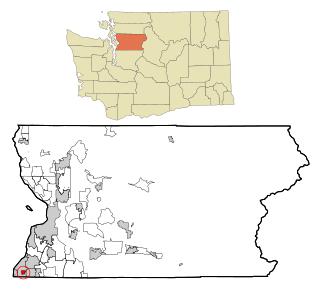
Klahanie is a planned community in Sammamish, Washington, United States. The population was 10,674 at the 2010 census. Prior to its annexation by the city of Sammamish in 2016, Klahanie was a census-designated place (CDP) in unincorporated King County.

References

  1. 1 2 U.S. Geological Survey Geographic Names Information System: East Renton Highlands, Washington
  2. 1 2 3 "Explore Census Data". United States Census Bureau . Retrieved June 24, 2022.
  3. "U.S. Census website". United States Census Bureau . Retrieved January 31, 2008.
  4. Hopkins, Jack (November 6, 1996). "Voters OK plans to create 2 cities". Seattle Post-Intelligencer . p. A17.
  5. Burkitt, Janet (March 13, 1988). "Anti-incorporation leaders' vote on Briarwood rejected". The Seattle Times . p. B4.
  6. "East Renton annexation information- King County". www.metrokc.gov. Archived from the original on October 10, 2006. Retrieved January 13, 2022.
  7. City of Renton Archived December 9, 2007, at the Wayback Machine . Accessed July 31, 2010.
  8. "Census of Population and Housing". United States Census Bureau . Retrieved July 31, 2010.
  9. U.S. Census Bureau Geography Division (December 21, 2020). 2020 Census – School District Reference Map: King County, WA (PDF) (Map). 1:80,000. U.S. Census Bureau. p. 2. Retrieved August 3, 2022.