North Bend, Washington

Last updated

North Bend, Washington
North Bend, Washington 98045.jpg
Aerial view of North Bend with Mount Si
Flag of North Bend, Washington.png
North Bend, WA logo.jpg
Motto: 
"Excellence in Government—Pride in Service"
King County Washington Incorporated and Unincorporated areas North Bend Highlighted.svg
Location of North Bend, Washington
Coordinates: 47°29′44″N121°47′12″W / 47.49556°N 121.78667°W / 47.49556; -121.78667
CountryUnited States
State Washington
County King
Incorporated March 12, 1909
Government
  Type Mayor–council [1]
   Mayor Mary Miller
Area
[2]
  Total4.42 sq mi (11.45 km2)
  Land4.35 sq mi (11.26 km2)
  Water0.07 sq mi (0.17 km2)
Elevation
[3]
443 ft (135 m)
Population
 (2020) [4]
  Total7,461
  Estimate 
(2022) [5]
7,902
  Density1,817/sq mi (701.7/km2)
Time zone UTC–8 (Pacific (PST))
  Summer (DST) UTC–7 (PDT)
ZIP Code
98045
Area code 425
FIPS code 53-49485
GNIS feature ID1523724 [3]
Website northbendwa.gov

North Bend is a city in King County, Washington, United States, on the outskirts of the Seattle metropolitan area. The population was 7,461 at the 2020 census. [4]

Contents

Since the closure of Weyerhaeuser's Snoqualmie sawmill, North Bend has become a prosperous bedroom community for Seattle, which is located about 30 miles (48 km) to the west. The town was made famous by David Lynch's television series Twin Peaks , which was partially filmed in North Bend. The community is also home to Nintendo North Bend, the main North American production facility and distribution center for the video game console manufacturer Nintendo.

History

Downtown North Bend with Mount Si in 1900 North Bend, WA 1900.jpg
Downtown North Bend with Mount Si in 1900
Jeremiah Borst (1830-1890), father of the Snoqualmie Valley community Jeremiah Borst (1830-1890).jpg
Jeremiah Borst (1830–1890), father of the Snoqualmie Valley community
William Taylor (1853-1941), founder of North Bend William Taylor (1853-1941) founder of North Bend.jpg
William Taylor (1853-1941), founder of North Bend
Downtown North Bend in 1943 Downtown North Bend, WA 1943.jpg
Downtown North Bend in 1943

The Snoqualmie Indian Tribe has resided in the Snoqualmie Prairie, including the area now known as North Bend, for thousands of years. This prairie southeast of Snoqualmie Falls was the ancestral home, hunting and forage grounds for the Snoqualmie people and was located in the upper Snoqualmie Valley near the Snoqualmie River fork confluence, Mount Si, and the western foothills of the Cascade Range.

One of the first American explorers to the upper Snoqualmie Valley was Samuel Hancock, who arrived in 1851. Hancock traveled upriver with his Snoqualmie guides, fording canoes around the falls to reach Snoqualmie Prairie, searching for coal deposits. He was taken to a "very extensive and fertile prairie" about two miles above Snoqualmie Falls. [6] The beautiful open grassland came to be known as the Snoqualmie Prairie, the heart of which is now known as Tollgate and Meadowbrook farms. [7] The Snoqualmies, led by Chief Patkanim, later sided with early settlers in the 1850s Indian Wars and were one of the signatory tribes of the Treaty of Point Elliott in 1855, which failed to designate an Indian reservation for the Snoqualmies. Some of the soldiers in those wars, such as the Kellogg brothers, established cabins near remaining Snoqualmie blockhouses; however, the most well known American resident in the valley was Jeremiah Borst, who arrived in 1858. [8]

After the Homestead Act of 1862, more settlers ventured to the Snoqualmie Valley, with the first families settling near Borst on the easterly end of Snoqualmie Prairie. In 1865, Matts Peterson homesteaded the site that ultimately became North Bend. [9] In 1879, Peterson sold the property to Borst and moved east of the Cascades. Borst wrote to Will Taylor, who had left the Pacific Northwest to pursue mining in California, and offered him the Peterson homestead in exchange for labor. Taylor returned and became the driving force in developing the town while expanding his property to include a thriving trading post and boarding house for travelers over Snoqualmie Pass. On February 16, 1889, with the upcoming railroad boom, Taylor formally platted a town including his farm, upcoming street plans and building lots, giving it the name "Snoqualmie Prairie". [10] Later that summer, competing Seattle land speculators subsequently platted nearby "Snoqualmie Falls", choosing a similar name. Pressured by demands of the Seattle, Lake Shore and Eastern Railway to avoid confusion, Taylor reluctantly renamed his town "Mountain View". [11] However, the U.S. Post Office Department objected to "Mountain View", as a town with that name already existed in northern Whatcom County. To conclude the matter Taylor agreed to permanently rename the community "North Bend", after its prime location near the large northward bend of the South and Middle Fork of the Snoqualmie River. [9] Taylor was proud of his new, thriving town, but by historical accounts, "He never got over having his town name taken away." [6] North Bend was officially incorporated on March 12, 1909, and grew throughout the 20th century, with an early economic focus on logging, sawmill production, agricultural and dairy farming. [12]

Geography

North Bend is located near the geographic center of King County at 47°29′44″N121°47′12″W / 47.49556°N 121.78667°W / 47.49556; -121.78667 (47.495658, -121.786778). [3]

According to the United States Census Bureau, the city has a total area of 4.42 square miles (11.45 km2), of which 4.35 square miles (11.27 km2) are land and 0.07 square miles (0.18 km2) are water. [2]

North Bend is located in the foothills of the Cascade Range, 30 miles (48 km) east of Seattle in the upper valley of the Snoqualmie River. The city is bordered to the northwest by the city of Snoqualmie. Both communities lie near the center of the Mountains to Sound Greenway. [13] Mount Si, the most prominent geological feature nearby, looms over the town. To the south is Rattlesnake Ridge. Mount Si stands at 4,167 feet (1,270 m) and towers above the town, itself at around 440 ft (130 m). A 4-mile (6 km) trail zigzags up to the summit with a vertical climb of 3,500 feet (1,100 m).

North Bend annexed some neighborhoods near Tanner and the Stilson area July 6, 2009. [14]

Climate

North Bend's climate (border between Cfb and Csb in the Köppen climate classification) is warm and generally dry during the summer when high temperatures tend to be in the 70s and mild to cold during the winter when high temperatures tend to be in the 30s and 40s. The town's location in the foothills means that it receives significantly higher annual precipitation than other suburbs to the west, and also translates into heavier snowfall in the winter. The all-time record high temperature is 115 °F (46 °C) set during the 2021 Western North America heat wave. The warmest month of the year is August with an average maximum temperature of 77 °F (25 °C), while the coldest month of the year is January with an average minimum temperature of 29 °F (−2 °C). The annual average precipitation in North Bend is 59.1 inches (1,500 mm) with 14.7 inches (370 mm) of snowfall. Winter months tend to be wetter than summer months. [15]

Climate data for North Bend, Washington
MonthJanFebMarAprMayJunJulAugSepOctNovDecYear
Record high °F (°C)67
(19)
75
(24)
79
(26)
90
(32)
97
(36)
115
(46)
105
(41)
102
(39)
98
(37)
95
(35)
75
(24)
67
(19)
115
(46)
Mean daily maximum °F (°C)40
(4)
44
(7)
52
(11)
59
(15)
65
(18)
71
(22)
76
(24)
77
(25)
70
(21)
59
(15)
48
(9)
42
(6)
59
(15)
Mean daily minimum °F (°C)29
(−2)
32
(0)
36
(2)
40
(4)
44
(7)
49
(9)
51
(11)
51
(11)
47
(8)
42
(6)
37
(3)
30
(−1)
41
(5)
Record low °F (°C)−11
(−24)
−9
(−23)
8
(−13)
24
(−4)
26
(−3)
31
(−1)
36
(2)
35
(2)
30
(−1)
23
(−5)
2
(−17)
−2
(−19)
−11
(−24)
Average precipitation inches (mm)8.25
(210)
5.88
(149)
5.88
(149)
4.41
(112)
3.49
(89)
2.84
(72)
1.31
(33)
1.49
(38)
2.97
(75)
5.46
(139)
8.49
(216)
8.61
(219)
59.1
(1,500)
Average snowfall inches (cm)3.7
(9.4)
4.3
(11)
1.3
(3.3)
0
(0)
0
(0)
0
(0)
0
(0)
0
(0)
0
(0)
0
(0)
1.6
(4.1)
3.8
(9.7)
14.7
(37)
Source: http://www.wrcc.dri.edu/cgi-bin/cliMAIN.pl?wa7773

Demographics

Historical population
CensusPop.Note
1910 299
1920 38729.4%
1930 54841.6%
1940 64617.9%
1950 78721.8%
1960 94520.1%
1970 1,62572.0%
1980 1,7014.7%
1990 2,57851.6%
2000 4,74684.1%
2010 5,73120.8%
2020 7,46130.2%
2022 (est.)7,902 [5] 5.9%
U.S. Decennial Census [16]
2020 Census [4]

2020 census

As of the 2020 census, there were 7,461 people, 2,775 households, and 2,031 families residing in the city. [17] The population density was 1,716.0 inhabitants per square mile (662.6/km2). There were 2,951 housing units.

2010 census

As of the 2010 census, there were 5,731 people, 2,210 households, and 1,487 families residing in the city. The population density was 1,343.2 inhabitants per square mile (518.6/km2). There were 2,348 housing units at an average density of 549.9 per square mile (212.3/km2). The racial makeup of the city was 90.7% White, 0.5% African American, 0.9% Native American, 1.6% Asian, 0.1% Pacific Islander, 2.5% from other races, and 3.6% from two or more races. Hispanic or Latino of any race were 6.4% of the population.

There were 2,210 households, of which 39.0% had children under the age of 18 living with them, 52.9% were married couples living together, 10.0% had a female householder with no husband present, 4.4% had a male householder with no wife present, and 32.7% were non-families. 24.8% of all households were made up of individuals, and 9% had someone living alone who was 65 years of age or older. The average household size was 2.57 and the average family size was 3.10.

The median age in the city was 38.7 years. 26.8% of residents were under the age of 18; 6.8% were between the ages of 18 and 24; 27.6% were from 25 to 44; 29.4% were from 45 to 64; and 9.4% were 65 years of age or older. The gender makeup of the city was 49.3% male and 50.7% female.

2000 census

As of the 2000 census, there were 4,746 people, 1,841 households, and 1,286 families residing in the city. The population density was 1,611.6 people per square mile (623.3/km2). There were 1,889 housing units at an average density of 641.4 per square mile (248.1/km2). The racial makeup of the city was 92.01% White, 0.70% African American, 1.03% Native American, 2.23% Asian, 0.17% Pacific Islander, 1.45% from other races, and 2.40% from two or more races. Hispanic or Latino of any race were 3.79% of the population.

There were 1,841 households, out of which 37.8% had children under the age of 18 living with them, 57.1% were married couples living together, 8.8% had a female householder with no husband present, and 30.1% were non-families. 23.7% of all households were made up of individuals, and 10.8% had someone living alone who was 65 years of age or older. The average household size was 2.53 and the average family size was 3.01.

In the city the population was 27.3% under the age of 18, 6.7% from 18 to 24, 37.1% from 25 to 44, 18.4% from 45 to 64, and 10.6% who were 65 years of age or older. The median age was 34 years. For every 100 females, there were 97.5 males. For every 100 females age 18 and over, there were 94.0 males.

The median income for a household in the city was $61,534, and the median income for a family was $69,402. Males had a median income of $57,333 versus $38,401 for females. The per capita income for the city was $28,229. About 2.1% of families and 4.7% of the population were below the poverty line, including 5.1% of those under age 18 and 3.0% of those age 65 or over.

Culture

Historic McGrath Hotel

The McGrath Hotel is located on the site of the cabin of William Henry Taylor, who platted North Bend in 1889. In October 1921, Jack McGrath and his wife Caroline purchased the site of their future venture, McGrath's Café; construction was completed as a one-story restaurant in 1922. In early 1926 the building was expanded two window bays westward, creating the hotel lobby (now the restaurant bar), and a second story was added to the entire structure to accommodate the hotel rooms of the new McGrath Hotel. After several years of deferred maintenance, the McGrath was purchased in 2000 by a local couple who spent two years rehabilitating the building. It is now listed on the National Register of Historic Places. The first floor currently houses a popular restaurant, the Iron Duck Public House.

Historic North Bend Theatre

On April 9, 1941, the North Bend Theatre [18] opened its doors. Built at a cost of $12,000 with 400 seats, the 4,000 square foot theater's occupancy is now 265 and it has continued operating as an independent movie theater since its opening day through seven family ownerships. [19] In 1999, the theatre underwent a major renovation. In 2013, the theater was once more saved from extinction by a successful $100,000+ fundraiser to convert the projection system from 35mm cellulose to 4K digital video. [20] During this series of renovations every part of the building was improved without sacrificing the distinctive character of this 1941 Art Deco theater. The renovation was awarded a Spellman Award, a King County honor, for the efforts. [19]

The movie house hosted the opening premier of the David Lynch movie, Twin Peaks: Fire Walk With Me . [19]

Valley Center Stage Community Theater

Valley Center Stage is a downtown community theater that promotes the performing arts in all its aspects. The theater has regular shows featuring classics and comedy. In addition, the theater offers opportunities to valley residents to participate in the theater's productions. [21]

Snoqualmie Valley Historical Museum

The Snoqualmie Valley Historical Museum, operated by the Snoqualmie Valley Historical Society, has been sharing the history of the Snoqualmie Valley for over 50 years. [22]

The Visitors Information Center is operated by the North Bend Downtown Foundation and represents a significant step towards downtown revitalization and growing community pride through volunteer efforts. The Mountain View Gallery features local artwork and hosts special events for the community throughout the year. The modern Northwest Regional style center features easy to use touchscreen computers for visitors to access a variety of information on local attractions and history. [23]

Transportation

North Bend is located 30 miles (48 km) east of Seattle on Interstate 90. There is regular bus service provided by King County Metro Transit on route 208. Metro buses are outfitted with bike racks. There are a number of van pools to Redmond, Bellevue, Seattle, and Renton. [24] Snoqualmie Valley Transportation provides door-to-door transportation for the public in North Bend, Snoqualmie, Preston, Fall City, Carnation, Duvall and Monroe. [25]

North Bend has a fairly modest trail system. [26] The Snoqualmie Valley Regional Trail stretches from Duvall through Carnation, Fall City, Snoqualmie, and North Bend to Rattlesnake Lake. [27] This 31.5-mile (50.7 km) trail connects to the Palouse to Cascades State Park Trail (which goes clear across Washington to the Idaho border) and to the city of Snoqualmie's extensive trail network. North Bend also has its own city trail system in downtown, the Si View neighborhood and along the South Fork of the Snoqualmie River in several places.

City park system

Outdoor recreation opportunities include hiking, fishing, mountain biking, climbing, river sports, wildlife observation, and enjoying scenic areas, all within city limits, not to mention the vast recreational playground immediately surrounding the city. Current city parks include Dahlgren Family Park, E.J. Roberts Park, Future Tennant Trailhead Park, Gardiner-Weeks Memorial Park, Meadowbrook Farm, Riverfront Park, Si View Neighborhood Park, Si View Park and Community Center, Snoqualmie Valley Trail, Tanner Trail, Tannerwood Neighborhood Park, Tollgate Farm, Tollgate Farm Park, Torguson Park and William Henry Taylor Park. [28]

Economy

Throughout the 20th century North Bend has maintained gradual growth with an early economic focus on logging, sawmill production, agricultural and dairy farming. Currently, North Bend is for the largest part a bedroom community to Bellevue and Seattle. In addition, North Bend has a growing tourism economy centered around the North Bend Premium Outlet Mall, Northwest Railway Museum train activities and Snoqualmie Pass recreational commerce related to hiking, backpacking, mountain biking, skiing, snowboarding and cross-country skiing. North Bend also has approximately 400 employees working for Nintendo North Bend.

Government and police

Presidential election results [30]
Year Republican Democratic Third Parties
2020 33.60% 1,60262.48%2,9793.92% 187

The city has a mayor–council government with a seven-member city council that meets twice a month. [31] The mayor is a separate position with four-year terms. Mary Miller was elected mayor in 2023. [32]

North Bend leans Democratic much like the rest of King County, giving a majority of the vote to Joe Biden in the 2020 presidential election.

Law enforcement services in North Bend have changed hands several times. From 1973 until March 8, 2014, the city contracted with the King County Sheriff's Office for law enforcement services within city limits. It was KCSO's longest standing contract at the time of its conclusion. Since March 8, 2014, the city has contracted for law enforcement services with the City of Snoqualmie Police Department.

Landmarks

King County and the city of North Bend have designated the following landmarks:

LandmarkBuiltListedAddressPhoto
Camp Waskowitz [33]
Namesake of Fritz Waskowitz [34]
1935199245509 SE 150th Street, North Bend Camp Waskowitz - 05.jpg
Si View Pool and Activity Center (WPA Park Building)1938-40 [33] 1984400 SE Orchard Dr., North Bend North Bend, WA - Si View Park 02.jpg
North Bend Historic Commercial District [33] 1889–19602000Bendigo Blvd. & No. Bend Way North Bend, WA - Cook Building.jpg
Tollgate Farmhouse [33] c.18902002SR 202 (near Boalch Avenue) Tollgate Farm House.jpg

See also

Related Research Articles

<span class="mw-page-title-main">King County, Washington</span> County in Washington, United States

King County is located in the U.S. state of Washington. The population was 2,269,675 in the 2020 census, making it the most populous county in Washington, and the 12th-most populous in the United States. The county seat is Seattle, also the state's most populous city.

<span class="mw-page-title-main">Carnation, Washington</span> City in Washington, United States

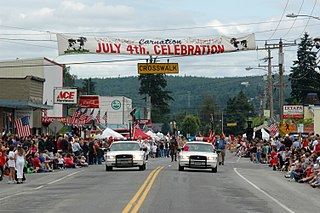
Carnation is a city in King County, Washington, United States. It was historically known as Tolt and lies at the confluence of the Snoqualmie and Tolt rivers.

<span class="mw-page-title-main">Duvall, Washington</span> City in Washington, United States

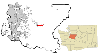
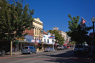
Duvall is a city in King County, Washington, United States, located on SR 203 halfway between Monroe and Carnation. The population was 8,034 at the 2020 census.

<span class="mw-page-title-main">Fall City, Washington</span> Census-designated place in Washington, United States

Fall City is an unincorporated community and census-designated place (CDP) in King County, Washington, United States, 25 miles (40 km) east of Seattle. The community lies along the Snoqualmie River and Raging River. The population was 2,032 as of the 2020 census.

<span class="mw-page-title-main">Sammamish, Washington</span> City in Washington, United States

Sammamish is a city in King County, Washington, United States. The population was 67,455 at the 2020 census. Located on a plateau, the city is bordered by Lake Sammamish to the west and the Snoqualmie Valley to the east. Sammamish is situated 20 miles east of Seattle, is a member of the Eastside, and is a part of the Seattle metropolitan area. Sammamish is an affluent community and has been ranked as one of the wealthiest cities in Washington.

<span class="mw-page-title-main">Snoqualmie, Washington</span> City in Washington, United States

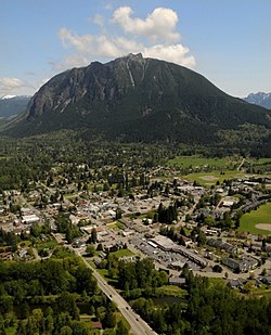
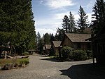
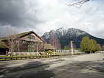
Snoqualmie is a city next to Snoqualmie Falls in King County, Washington, United States. It is 28 miles (45 km) east of Seattle. Snoqualmie city is home to the Northwest Railway Museum. The population was 14,121 at the 2020 census.

<span class="mw-page-title-main">Riverpoint, Washington</span> Census-designated place in Washington, United States

Riverpoint is an unincorporated community and census-designated place (CDP) in east King County, Washington, United States. As of the 2020 census, it had a population of 774. At the 2010 census, the area was listed as the Tanner CDP and had a population of 1,018 over a larger area.

<span class="mw-page-title-main">Snoqualmie Pass, Washington</span> Census-designated place in Washington, United States

Snoqualmie Pass is a census-designated place (CDP) in Kittitas County, Washington, United States. It includes the unincorporated community of Hyak. The population was 311 at the 2010 census.

<span class="mw-page-title-main">Centralia, Washington</span> City in Washington, United States

Centralia is a city in Lewis County, Washington, United States. It is located along Interstate 5 near the midpoint between Seattle and Portland, Oregon. The city had a population of 18,183 at the 2020 census. Centralia is twinned with Chehalis, located to the south near the confluence of the Chehalis and Newaukum rivers.

<span class="mw-page-title-main">Fords Prairie, Washington</span> Census-designated place in Washington, United States

Fords Prairie is an unincorporated community and census-designated place (CDP) in Lewis County, Washington, United States. The population was 2,234 at the 2020 census.
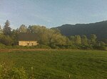
<span class="mw-page-title-main">Mount Si</span> Mountain in Washington, United States

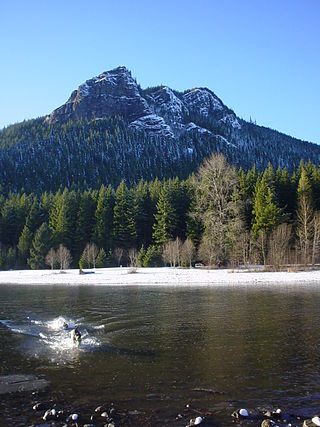
Mount Si is a mountain in the northwest United States, east of Seattle, Washington. It lies on the western margin of the Cascade Range just above the coastal plains around Puget Sound, and towers over the nearby town of North Bend. Mount Si and neighboring mountain Little Si were named after local homesteader Josiah "Uncle Si" Merritt. The mountain became nationally familiar in the early 1990s with the television series Twin Peaks, which was filmed in North Bend.

The Seattle, Lake Shore and Eastern Railway (SLS&E) was a railroad founded in Seattle, Washington, on April 28, 1885, with three tiers of purposes: Build and run the initial line to the town of Ballard, bring immediate results and returns to investors; exploit resources east in the valleys, foothills, Cascade Range, and Eastern Washington in 19th-century style, attracting more venture capital; and boost a link to a transcontinental railroad for Seattle, the ultimate prize for incorporation. The historical accomplishment of the line was Seattle to Sumas at the border, with British Columbia, Canada, connecting with the Canadian Pacific transcontinental at the border at Huntingdon, British Columbia, now part of the City of Abbotsford.

<span class="mw-page-title-main">Burke–Gilman Trail</span> Rail trail in Seattle, US

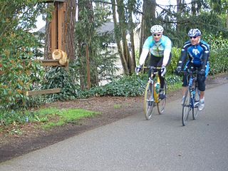
The Burke–Gilman Trail is a rail trail in King County, Washington. The 27-mile (43 km) multi-use recreational trail is part of the King County Regional Trail System and occupies an abandoned Seattle, Lake Shore and Eastern Railway (SLS&E) corridor.

<span class="mw-page-title-main">Rattlesnake Ridge</span> Mountain in Washington, United States

Rattlesnake Ridge, known as daʔšədabš to the Snoqualmie people, is the ridge of Rattlesnake Mountain located south of North Bend, Washington, United States. The western end is near the intersection of State Route 18 and I-90 in Snoqualmie, Washington, and runs southeast about 7 miles (11 km) or 11 miles (18 km) by trail. It is the highest and easternmost of the Issaquah Alps. A maze of abandoned logging roads and constructed trails have been strung together to provide a 10.5-mile (16.9 km) footpath from the Snoqualmie Point trailhead at Exit 27 on I-90 all the way to the Rattlesnake Lake trailhead near Exit 32.

<span class="mw-page-title-main">Palouse to Cascades State Park Trail</span>

The Palouse to Cascades State Park Trail, formerly known as the John Wayne Pioneer Trail and the Iron Horse Trail, is a rail trail that spans most of the U.S. state of Washington. It follows the former railway roadbed of the Chicago, Milwaukee, St. Paul & Pacific Railroad for 300 miles (480 km) across two-thirds of the state, from the western slopes of the Cascade Mountains to the Idaho border.

<span class="mw-page-title-main">Snoqualmie Valley Regional Trail</span> Rail trail in Washington

The Snoqualmie Valley Regional Trail is a rail trail in King County, Washington. The 29-mile (47 km) trail follows a portion of the former alignment of the Milwaukee Road, which was constructed in 1911 and abandoned in 1973.

<span class="mw-page-title-main">Will Taylor (land speculator)</span>

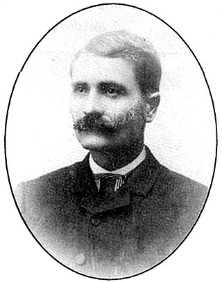
William Taylor, (1853–1941) was a pioneer, Snoqualmie Valley driving force and the founder of North Bend, Washington in February 1889.

<span class="mw-page-title-main">Jeremiah Borst</span>

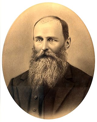
Jeremiah W. Borst was the first permanent white settler in the upper Snoqualmie Valley region.

<span class="mw-page-title-main">Raging River</span> River in the United States of America

The Raging River is a tributary of the Snoqualmie River in western Washington state in the United States. It is located in the western foothills of the Cascade Mountains in east central King County, Washington. It gets its name from the large amount of water it sometimes carries. The record discharge at the gaging station is over 4,000 cubic feet (110 m3) per second. The Raging is a salmon-bearing river and supports one-fifth of the Snoqualmie River's chinook runs.

<span class="mw-page-title-main">Snoqualmie Valley School District</span> School district in Washington, United States

The Snoqualmie Valley School District is located in King County, Washington about 40 miles (64 km) from Seattle at the foothills of Snoqualmie Pass. It encompasses over 400 square miles (1,000 km2), making it geographically one of the largest school districts in Washington state. The district has an enrollment of approximately 7,200 students.

References

  1. "North Bend Municipal Code". Code Publishing Company. Retrieved April 10, 2022.
  2. 1 2 "2023 U.S. Gazetteer Files: Minnesota". United States Census Bureau. Retrieved March 30, 2024.
  3. 1 2 3 U.S. Geological Survey Geographic Names Information System: North Bend, Washington
  4. 1 2 3 "Explore Census Data". United States Census Bureau . Retrieved January 26, 2023.
  5. 1 2 "City and Town Population Totals: 2020–2022". United States Census Bureau. March 30, 2024. Retrieved March 30, 2024.
  6. 1 2 Ada S. Hill, A History of the Snoqualmie Valley (North Bend: Snoqualmie Valley Historical Society, 1970, fifth printing, 1981)
  7. "North Bend: How Our 100 Years Began". City of North Bend. Retrieved January 16, 2024.
    • Evans, Jack R. (1990). A Little History of North Bend - Snoqualmie. SCW Publications. ISBN   1-877882-03-8.
  8. 1 2 Majors, Harry M. (1975). Exploring Washington. Van Winkle Publishing Co. p. 86. ISBN   978-0-918664-00-6.
  9. "Snoqualmie Valley Chamber of Commerce". Archived from the original on January 17, 2007. Retrieved April 10, 2007.
  10. "North Bend Beginnings: Snoqualmie (renamed Mountain View, renamed North Bend) Post Office opens on May 20, 1870. - HistoryLink.org".
  11. "North Bend -- Thumbnail History". www.historylink.org.
  12. "Communities that Thrive". Mountains to Sound Greenway Trust. Retrieved January 30, 2013.
  13. Michael Rowe (August 20, 2009). "North Bend gets official number on annexation". SnoValley Star. Archived from the original on December 6, 2011. Retrieved September 19, 2011.
  14. "North Bend, WA Weather". idcide.com. Retrieved May 17, 2009.
  15. "Census of Population and Housing". United States Census Bureau. Retrieved June 4, 2015.
  16. "US Census Bureau, Table P16: Household Type". United States Census Bureau. Retrieved March 30, 2024.
  17. "northbendtheatre.com" . Retrieved October 2, 2014.
  18. 1 2 3 Liu, Qina (September 23, 2022). "North Bend Theatre: Home of '1,000 stories'". The Seattle Times. Retrieved November 25, 2022.
  19. "After Successful $100,000 Fundraiser, North Bend Theatre Debuts New State-of-the-Art Movie Projector - Living Snoqualmie". September 15, 2013.
  20. "Valley Center Stage - Comedy * Variety * Music * Playhouse". Archived from the original on April 21, 2009. Retrieved April 22, 2009.
  21. "Snoqualmie Valley Historical Museum" . Retrieved October 2, 2014.
  22. "Visitor Information Center". North Bend.
  23. Springer, Natalie "Metro Transit van-pooling reaches an all-time high." Seattle Times, March 5, 2004
  24. "Snoqualmie Valley Transportation". Archived from the original on 6 October 2014. Retrieved 2 October 2014.
  25. "City of North Bend Plan Trail Map" (PDF).[ permanent dead link ]
  26. "Snoqualmie Valley Trail Map" (PDF). duvallwa.gov. Archived from the original (PDF) on May 27, 2010. Retrieved June 4, 2009.
  27. "Parks & Trails - North Bend, WA - Official Website". northbendwa.gov.
  28. Yam, Marcus (July 2, 2013). "Cooling off at the Dairy Freeze". The Seattle Times.
  29. King County Elections
  30. "Chapter 2.04: Council". City of North Bend. Retrieved January 16, 2024 via Code Publishing Company.
  31. Sires, Cameron (January 3, 2024). "North Bend's new mayor is ready to open more doors". Snoqualmie Valley Record. Retrieved January 16, 2024.
  32. 1 2 3 4 King County and Local Landmarks List [ permanent dead link ], King County (undated, last modified February 26, 2003). Accessed online May 9, 2009
  33. "Husky Legend: Fritz Waskowitz - GoHuskies.com - University of Washington Athletics".