
The Muckleshoot Indian Tribe, also known as the Muckleshoot Tribe, is a federally-recognized tribe located in Auburn, Washington. The tribe governs the Muckleshoot Reservation and is composed of descendants of the Duwamish, Stkamish, Smulkamish, Skopamish, Yilalkoamish, and Upper Puyallup peoples. The Muckleshoot Indian Tribe was formally established in 1936, after the Indian Reorganization Act of 1934, but its origins lie in the creation of the Muckleshoot Reservation in 1874 and the treaties of Medicine Creek (1854) and Point Elliott (1855).

Tukwila is a suburban city in King County, Washington, United States, located immediately to the south of Seattle. The population was 21,798 at the 2020 census.

Auburn is a city in King County, Washington, United States. The population was 87,256 at the 2020 Census. Auburn is a suburb in the Seattle metropolitan area, and is currently ranked as the 15th most populous city in the state of Washington.
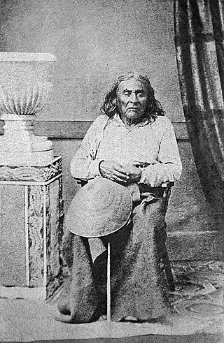
Seattle was a leader of the Duwamish and Suquamish peoples. A leading figure among his people, he pursued a path of accommodation to white settlers, forming a personal relationship with Doc Maynard. The city of Seattle, in the U.S. state of Washington, was named after him. A widely publicized speech arguing in favor of ecological responsibility and respect for Native Americans' land rights had been attributed to him.

Lake Washington is a large freshwater lake adjacent to the city of Seattle, Washington, United States. It is the largest lake in King County and the second largest natural lake in the state of Washington, after Lake Chelan. It borders the cities of Seattle on the west, Bellevue and Kirkland on the east, Renton on the south, and Kenmore on the north, and encloses Mercer Island. The lake is fed by the Sammamish River at its north end and the Cedar River at its south.
Green River may refer to:

The Duwamish River is the name of the lower 12 miles (19 km) of Washington state's Green River. Its industrialized estuary is known as the Duwamish Waterway. Although heavily polluted, it is an important habitat for the wildlife. Important to the Duwamish people, the Duwamish Longhouse and Cultural Center is on the west bank of the river and several parks have indigenous Lushootseed names.

The Duwamish are a Lushootseed-speaking Southern Coast Salish people in western Washington, and the Indigenous people of metropolitan Seattle.

The Green River is a 65-mile (105 km) long river in the state of Washington in the United States, arising on the western slopes of the Cascade Range south of Interstate 90.

The Industrial District is a neighborhood and the principal industrial area of Seattle, Washington. It is bounded on the west by the Duwamish River and Elliott Bay, beyond which lies Delridge of West Seattle; on the east by Interstate 5, beyond which lies Beacon Hill; on the north by S King and S Dearborn Streets, beyond which lie Pioneer Square and southwest International District of Downtown; and on the south by the main lines of the BNSF Railway and Union Pacific Railroad, or about S Lucille Street, beyond which is Georgetown. SoDo is the name of the northwest portion of the neighborhood, named for its being South of Downtown. SoDo is the location of T-Mobile Park, home of the Seattle Mariners, and Lumen Field, home of the Seattle Seahawks and Seattle Sounders FC. Lumen Field was also the site of the former Kingdome.

Lake City is a neighborhood and the northeast region of Seattle, centered along Lake City Way NE (SR-522), 7–8 miles (11–13 km) northeast of downtown Seattle. A broader definition of the Lake City area includes all the land between 15th Avenue NE and Lake Washington, and between NE 95th and 98th streets to the Seattle city limits at NE 145th Street. Lake City encompasses much of the Thornton Creek watershed, the focus of a long restoration campaign by citizens and Seattle Public Utilities staff to enhance the residential environment of Lake City.
In the history of Seattle before white settlement, thirteen prominent villages existed in what is now the city of Seattle. The people living near Elliott Bay, and along the Duwamish, Black and Cedar Rivers were collectively known as the doo-AHBSH, or People of the Doo ("Inside"). Four prominent villages existed near what is now Elliott Bay and the (then-estuarial) lower Duwamish River. Before civil engineers rechanneled the Duwamish, the area had extensive tidelands, and had an abundance of seafoods.
The Duwamish tribe is a Native American tribe in western Washington, and the indigenous people of metropolitan Seattle. The Duwamish tribe today includes the People of the Inside (Dxw'Dəw?Abš), for Elliott Bay environs today; and the People of the Large Lake (Xacuabš), for those around Lake Washington of today.
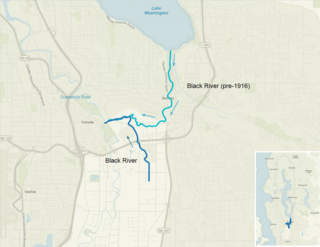
The Black River is a tributary of the Duwamish River in King County in the U.S. state of Washington. It drained Lake Washington until 1916, when the opening of the Lake Washington Ship Canal lowered the lake, causing part of the Black River to dry up. It still exists as a dammed stream about 2 miles (3.2 km) long.
Orillia, Washington was a former community, southwest of Renton in the Green River Valley of King County in the U.S. state of Washington. At one time, it had a schoolhouse. Today it lies on the border between the cities of Kent, Tukwila and Renton.
Riverton was a census-designated place (CDP) in King County, Washington, United States. The population was 6,407 at the 2010 census. Riverton was formerly part of the Riverton-Boulevard Park CDP, which was split up for the 2010 census into Riverton and Boulevard Park. In April 2010 the community was annexed by the city of Burien and is no longer a CDP.

Foster, Washington was a former community in King County in the U.S. state of Washington. After being annexed in 1989, Foster's former area is a part of the city of Tukwila.
O'Brien, Washington was a former community, north of Kent in the Green River Valley of King County in the U.S. state of Washington. It was just north of today's Green River Natural Resources Area, on the right bank of the river. At one time, it had a post office and a school.
Thomas was a former community, north of Auburn in the Green River Valley of King County in the U.S. state of Washington. The also defunct community of Christopher stood between Thomas and Auburn. It was situated on the left bank of the river. At one time, it had a post office and a school.

The Green River Trail is a 19.6-mile (31.5 km) pedestrian and bicycle trail in King County, Washington, USA. It runs along the banks of the Duwamish and Green Rivers, crossing the river several times on bridges. The trail goes through a variety of landscapes, ranging from industrial to rural.


