
The Denver and Rio Grande Western Railroad, often shortened to Rio Grande, D&RG or D&RGW, formerly the Denver & Rio Grande Railroad, was an American Class I railroad company. The railroad started as a 3 ft narrow-gauge line running south from Denver, Colorado, in 1870. It served mainly as a transcontinental bridge line between Denver and Salt Lake City, Utah. The Rio Grande was also a major origin of coal and mineral traffic.

The Cascade Range or Cascades is a major mountain range of western North America, extending from southern British Columbia through Washington and Oregon to Northern California. It includes both non-volcanic mountains, such as many of those in the North Cascades, and the notable volcanoes known as the High Cascades. The small part of the range in British Columbia is referred to as the Canadian Cascades or, locally, as the Cascade Mountains. The highest peak in the range is Mount Rainier in Washington at 14,411 feet (4,392 m).

BNSF Railway is the largest freight railroad in the United States. One of six North American Class I railroads, BNSF has 36,000 employees, 33,400 miles (53,800 km) of track in 28 states, and over 8,000 locomotives. It has three transcontinental routes that provide rail connections between the western and eastern United States. BNSF trains traveled over 169 million miles in 2010, more than any other North American railroad.

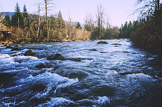
The Green River is a 65-mile (105 km) long river in the state of Washington in the United States, arising on the western slopes of the Cascade Range south of Interstate 90.

The Grand Trunk Railway was a railway system that operated in the Canadian provinces of Quebec and Ontario and in the American states of Connecticut, Maine, Michigan, Massachusetts, New Hampshire, and Vermont. The railway was operated from headquarters in Montreal, Quebec, with corporate headquarters in London, United Kingdom. It cost an estimated $160 million to build. The Grand Trunk system and the Canadian Government Railways were precursors of today's Canadian National Railway.
The Northern Pacific Railway was an important transcontinental railroad that operated across the northern tier of the western United States, from Minnesota to the Pacific Northwest. It was approved and chartered in 1864 by the 38th Congress of the United States in the national / federal capital of Washington, D.C., during the last years of the American Civil War (1861-1865), and given nearly 40 million acres of adjacent land grants, which it used to raise additional money in Europe, for construction funding.

Lester is a ghost town near Stampede Pass, just south of Snoqualmie Pass in King County, founded in 1892 by the Northern Pacific Railway. Lester is located along what is currently National Forest Development Road 54, on land owned by Tacoma Water, a division of Tacoma Public Utilities.

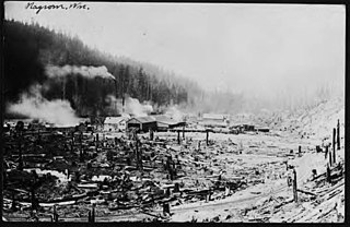
Hot Springs is a ghost town in King County, Washington, United States. Properly Green River Hot Springs, the town was first settled under the name Kendon by the Northern Pacific Railway in 1886. Hot Springs was at one time home to a large sanatorium built around the natural hot springs in the area, and by 1907–1908 had a population of 225 with two doctors. The sanatorium was reported to have been an impressive facility, having nice suites, bowling alleys and pool tables. A 1904 envelope has a return address, "The Kloeber, J. S. Kloeber, M.D. Green River Hot Springs, Wash.". The area was also home to Harvey Dean's mill. By 1913–14 the town's population had dropped to 65, with no businesses mentioned. Evidence points to the fact that sometime before 1913–14 the sanatorium had burned down. By 1918, the town had virtually vanished, only being listed as a "Discontinued Post Office."

Weston is a ghost town in Washington State founded circa 1900. Located at the foot of the western 2.2 percent grade of the Northern Pacific Railway's climb up Stampede Pass to Stampede Tunnel, the town served as the western helper station on the pass, counterpart to Easton, Washington. Facilities included an engine house, telegraph station, water tank, turntable and some ancillary residences and eating houses.
Stampede Pass is a mountain pass in the northwest United States, through the Cascade Range in Washington. Southeast of Seattle and east of Tacoma, its importance to transportation lies almost entirely with railroading, as no paved roads cross it. It is approximately twelve miles (20 km) south-southeast of Snoqualmie Pass, the gap for Interstate 90, and two miles (3 km) south of Keechelus Lake.

Amelia Court House is the county seat of Amelia County in the U.S. state of Virginia and a census-designated place (CDP). The population as of the 2010 census was 1,099. The town was named for Princess Amelia of Great Britain, the second daughter of Great Britain's King George II, in 1735.

The Northern Transcon, a route operated by the BNSF Railway, traverses the most northerly route of any railroad in the western United States. This route was originally part of the Chicago, Burlington and Quincy Railroad, Northern Pacific Railway, Great Northern Railway and Spokane, Portland and Seattle Railway systems, merged into the Burlington Northern Railroad system in 1970.

U.S. Route 395 (US 395) is a United States Numbered Highway, stretching from Hesperia, California to the Canadian border in Laurier, Washington. The California portion of US 395 is a 557-mile (896 km) route which traverses from Interstate 15 (I-15) in Hesperia, north to the Oregon state line in Modoc County near Goose Lake. The route clips into Nevada, serving the cities Carson City and Reno, before returning to California.

Snoqualmie Pass is a mountain pass that carries Interstate 90 (I-90) through the Cascade Range in the U.S. state of Washington. The pass summit is at an elevation of 3,015 feet (919 m), on the county line between Kittitas County and King County.

The Meeker Southern Railroad is a Class III shortline railroad owned by Ballard Terminal Railroad Company LLC that travels approximately 5 miles (8.0 km) between East Puyallup ("Meeker") and McMillin, Washington, United States.
Nagrom is a ghost town in King County, Washington, United States.

The Balboa Line was the southernmost route of the Pacific Electric Railway. It ran between Downtown Los Angeles and the Balboa Peninsula in Orange County by way of North Long Beach, though the route was later cut back to the Newport Dock. It was designated as route 17.

Kanaskat, Washington is an unincorporated community in King County, Washington, United States.
Kanaskat-Palmer State Park is a 320-acre (130 ha) Washington state park on the Green River in King County. The park has 2 miles (3.2 km) of river shoreline and offers picnicking, camping, 3 miles (4.8 km) of trails for hiking and biking, expert-level rafting and kayaking in the Green River Gorge, fishing, swimming, birdwatching, wildlife viewing, and horseshoes.

San Simon is a census-designated place in Cochise County, Arizona, United States. As of the 2010 census, it had a population of 165. San Simon is located along Interstate 10, 40 miles (64 km) east of Willcox. The community has a ZIP code of 85632.


