America's first transcontinental railroad was a 1,911-mile (3,075 km) continuous railroad line built between 1863 and 1869 that connected the existing eastern U.S. rail network at Council Bluffs, Iowa, with the Pacific coast at the Oakland Long Wharf on San Francisco Bay. The rail line was built by three private companies over public lands provided by extensive U.S. land grants. Building was financed by both state and U.S. government subsidy bonds as well as by company-issued mortgage bonds. The Western Pacific Railroad Company built 132 miles (212 km) of track from the road's western terminus at Alameda/Oakland to Sacramento, California. The Central Pacific Railroad Company of California (CPRR) constructed 690 miles (1,110 km) east from Sacramento to Promontory Summit, Utah Territory. The Union Pacific Railroad (UPRR) built 1,085 miles (1,746 km) from the road's eastern terminus at the Missouri River settlements of Council Bluffs and Omaha, Nebraska, westward to Promontory Summit.

Easton is an unincorporated community and census-designated place (CDP) in Kittitas County, Washington, United States. The population was 478 at the 2010 census. Easton is the annual site of the start/finish line for the Cascade Crest 100-mile ultra-running race.

The Green River is a 65-mile (105 km) long river in the state of Washington in the United States, arising on the western slopes of the Cascade Range south of Interstate 90.

The Connaught Tunnel is in southeastern British Columbia, on the Revelstoke–Donald segment. The 5.022-mile (8.082 km) tunnel carries the Canadian Pacific Kansas City (CPKC) main line under Mount Macdonald in the Selkirk Mountains. The tunnel, opened by the Canadian Pacific Railway (CP) in 1916, replaced the previous routing over Rogers Pass.

A horseshoe curve is a class of climbing curve in a roadbed that reverses turn direction (inflection) twice on either side of a single tight curve that varies through an angle of about 180 degrees or more.

Stevens Pass is a mountain pass through the Cascade Mountains located at the border of King County and Chelan County in Washington, United States. U.S. Route 2 travels over the pass, reaching a maximum elevation of 4,061 feet (1,238 m). The Pacific Crest Trail crosses the highway at Stevens Pass. The BNSF Railway's Cascade Tunnel lies 1,180 feet (400 m) below the pass summit.
Palmer is an unincorporated community in King County, Washington, United States. It is located along the Green River next to the Kanaskat-Palmer State Park.

Lester is a ghost town near Stampede Pass, just south of Snoqualmie Pass in King County, founded in 1892 by the Northern Pacific Railway. Lester is located along what is currently National Forest Development Road 54, on land owned by Tacoma Water, a division of Tacoma Public Utilities.

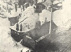
Hot Springs is a ghost town in King County, Washington, United States. Properly Green River Hot Springs, the town was first settled under the name Kendon by the Northern Pacific Railway in 1886. Hot Springs was at one time home to a large sanatorium built around the natural hot springs in the area, and by 1907–1908 had a population of 225 with two doctors. The sanatorium was reported to have been an impressive facility, having nice suites, bowling alleys and pool tables. A 1904 envelope has a return address, "The Kloeber, J. S. Kloeber, M.D. Green River Hot Springs, Wash.". The area was also home to Harvey Dean's mill. By 1913–14 the town's population had dropped to 65, with no businesses mentioned. Evidence points to the fact that sometime before 1913–14 the sanatorium had burned down. By 1918, the town had virtually vanished, only being listed as a "Discontinued Post Office."
Stampede Pass is a mountain pass in the northwest United States, through the Cascade Range in Washington. Southeast of Seattle and east of Tacoma, its importance to transportation lies almost entirely with railroading, as no paved roads cross it. It is approximately twelve miles (20 km) south-southeast of Snoqualmie Pass, the gap for Interstate 90, and two miles (3 km) south of Keechelus Lake.

Hyak is an unincorporated community located on Snoqualmie Pass in Kittitas County, Washington. It is located within the Snoqualmie Pass CDP.

The Palouse to Cascades State Park Trail, formerly known as the John Wayne Pioneer Trail and the Iron Horse Trail, is a rail trail that spans most of the U.S. state of Washington. It follows the former railway roadbed of the Chicago, Milwaukee, St. Paul & Pacific Railroad for 300 miles (480 km) across two-thirds of the state, from the western slopes of the Cascade Mountains to the Idaho border.

The Northern Transcon, a route operated by the BNSF Railway, traverses the most northerly route of any railroad in the western United States. This route was originally part of the Chicago, Burlington and Quincy Railroad, Northern Pacific Railway, Great Northern Railway and Spokane, Portland and Seattle Railway systems, merged into the Burlington Northern Railroad system in 1970.

Keechelus Lake is a lake and reservoir in the northwest United States, near Hyak in Kittitas County, Washington. Approximately fifty miles (80 km) southeast of Seattle and a few miles southeast of Snoqualmie Pass, it is the source of the Yakima River.

U.S. Route 2 (US 2) is a component of the United States Numbered Highway System that connects the city of Everett in the U.S. state of Washington to the Upper Peninsula of Michigan, with a separate segment that runs from Rouses Point, New York, to Houlton, Maine. Within Washington, the highway travels on a 326-mile-long (525 km) route that connects the western and eastern regions of the state as a part of the state highway system and the National Highway System. US 2 forms parts of two National Scenic Byways, the Stevens Pass Greenway from Monroe to Cashmere and the Coulee Corridor Scenic Byway near Coulee City, and an All-American Road named the International Selkirk Loop within Newport.
Nagrom is a ghost town in King County, Washington, United States.
The Puget Sound Shore Railroad and successor Northern Pacific and Puget Sound Shore Railroad built a branch line of the Northern Pacific Railroad between Puyallup and Seattle, Washington, U.S., and partially constructed a line around the east side of Lake Washington to Woodinville.

The Central Corridor is a rail line operated by the Union Pacific Railroad from near Winnemucca, Nevada to Denver, Colorado in the western United States. The line was created after the merger with the Southern Pacific Transportation Company by combining portions of lines built by former competitors. No portion of the line was originally built by the Union Pacific; in fact, some portions were built specifically to compete with the Union Pacific's Overland Route. The line is known for significant feats of engineering while crossing the Wasatch Mountains of Utah and the Rocky Mountains of Colorado. The line features numerous tunnels; the longest and highest of these is the Moffat Tunnel.

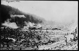
Martin is an extinct town in the northwest United States, in Kittitas County, Washington. Stampede Pass is near to the west.