Baring, Washington

Last updated • 3 min readFrom Wikipedia, The Free Encyclopedia

Baring, Washington
King County Washington Incorporated and Unincorporated areas Baring Highlighted.svg
Location of Baring, Washington
Coordinates: 47°45′58″N121°28′49″W / 47.76611°N 121.48028°W / 47.76611; -121.48028
Country United States
State Washington
County King
Area
  Total
1.13 sq mi (2.93 km2)
  Land1.04 sq mi (2.70 km2)
  Water0.09 sq mi (0.24 km2)
Elevation
[1]
774 ft (236 m)
Population
 (2020) [2]
  Total
255
  Density211/sq mi (81.6/km2)
Time zone UTC-8 (Pacific (PST))
  Summer (DST) UTC-7 (PDT)
ZIP code
98224
Area code 360
FIPS code 53-04300 [3]
GNIS feature ID2407797 [1]

Baring is an unincorporated community and census-designated place (CDP) in King County, Washington, United States. The population was 255 at the 2020 census, [2] up from 220 at the 2010 census. [4] It is located on U.S. Highway 2 about 23 miles (37 km) west of Stevens Pass, along a very flat and straight three-mile section of highway that has been dubbed the "Baring Straight" (a play on the Bering Strait between Alaska and Russia), since US-2 is otherwise hilly and curvy through the mountains. The settlement was first known as "Salmon", but by 1909 it was known as Baring. [5]

Contents

History

Baring in 1912 Scene at Baring showing the Baring bar and barber shop, 1912 (PICKETT 734).jpeg
Baring in 1912

The towns in the Skykomish River valley were established based on the railway and the roads built to cross the Cascade Mountains at Stevens Pass. In the late 19th century during the expansion of the Great Northern Railway, the railway's chief locating engineer, John F. Stevens, surveyed the area and identified Stevens Pass as the ideal route for crossing the North Cascades. The first train passed through in June 1893. Early road development in the area included the Skykomish Tote Road, connecting towns along the rail line, which can be seen in photographs and maps from the late 19th and early 20th centuries. [6]

In 1912, local citizens established a Good Roads Club to promote the construction of a cross-Cascades highway. By 1913, King, Chelan, and Snohomish counties collaborated on the Cascade Scenic Highway project (King County Road No. 999), which was surveyed the same year. However, completion of the highway was delayed due to World War I, funding, and construction obstacles. King County finished its 28-mile section by 1917, but the first automobiles did not cross until 1924, with the official opening taking place in July 1925. [7]

The Cascade Scenic Highway and Stevens Pass Highway (now US 2) played a key role in the region's development by improving access and connectivity. The Stevens Pass Highway became State Road 15 in the 1930s, and was later realigned, paved, and renamed multiple times before ultimately becoming US 2 in the late 1940s.

1902 US Geological Survey 1902 USGS topo map of Baring, Washington.jpg
1902 US Geological Survey

Geography

Baring is located in northeastern King County in the valley of the South Fork Skykomish River. US-2 leads southeast 7 miles (11 km) to Skykomish and northwest 41 miles (66 km) to Everett.

According to the United States Census Bureau, the Baring CDP has a total area of 1.1 square miles (2.9 km2), of which 1.0 square mile (2.7 km2) is land and 0.1 square miles (0.2 km2), or 8.02%, is water. [4]

Demographics

Historical population
CensusPop.Note
1910 140
1920 71−49.3%
1930 11156.3%
1940 105−5.4%
1990 161
2000 23344.7%
2010 220−5.6%
2020 25515.9%
U.S. Decennial Census [8]

As of the 2000 United States Census, [3] there were 233 people, 105 households, and 59 families in the CDP. The population density was 139.0 people per square mile (53.5/km²). There were 207 housing units at an average density of 123.5/sq mi (47.6/km²). The racial makeup of the CDP was 90.56% White, 2.58% Native American, 0.86% Asian, 0.43% Pacific Islander, and 5.58% from two or more races. Hispanic or Latino of any race were 2.15% of the population.

There were 105 households, out of which 22.9% had children under the age of 18 living with them, 49.5% were married couples living together, 4.8% had a female householder with no husband present, and 43.8% were non-families. 32.4% of all households were made up of individuals, and 4.8% had someone living alone who was 65 years of age or older. The average household size was 2.22 and the average family size was 2.81.

The population contained 19.7% under the age of 18, 3.0% from 18 to 24, 37.8% from 25 to 44, 29.2% from 45 to 64, and 10.3% who were 65 years of age or older. The median age was 40 years. For every 100 females there were 121.9 males. For every 100 females age 18 and over, there were 122.6 males.

The median income for a household in the CDP was $40,875, and the median income for a family was $46,500. Males had a median income of $38,125 versus $32,292 for females. The per capita income for the CDP was $22,571. About 6.9% of families and 7.2% of the population were below the poverty line, including 5.4% of those under the age of eighteen and none of those 65 or over.

Climate

According to the Köppen Climate Classification system, Baring has an Oceanic climate, abbreviated "Cfb" on climate maps.

Climate data for Baring (1991–2020 normals, extremes 1970–present)
MonthJanFebMarAprMayJunJulAugSepOctNovDecYear
Record high °F (°C)61
(16)
73
(23)
80
(27)
91
(33)
100
(38)
107
(42)
101
(38)
98
(37)
98
(37)
86
(30)
70
(21)
60
(16)
107
(42)
Mean maximum °F (°C)52.7
(11.5)
59.4
(15.2)
67.8
(19.9)
78.0
(25.6)
84.7
(29.3)
86.8
(30.4)
91.7
(33.2)
90.9
(32.7)
85.8
(29.9)
72.7
(22.6)
59.0
(15.0)
51.2
(10.7)
94.3
(34.6)
Mean daily maximum °F (°C)41.9
(5.5)
46.6
(8.1)
51.6
(10.9)
58.5
(14.7)
66.0
(18.9)
69.4
(20.8)
76.7
(24.8)
77.1
(25.1)
70.9
(21.6)
58.3
(14.6)
47.4
(8.6)
40.8
(4.9)
58.8
(14.9)
Daily mean °F (°C)36.7
(2.6)
39.2
(4.0)
42.8
(6.0)
48.2
(9.0)
55.0
(12.8)
58.8
(14.9)
64.4
(18.0)
64.7
(18.2)
59.5
(15.3)
49.9
(9.9)
41.6
(5.3)
36.2
(2.3)
49.8
(9.9)
Mean daily minimum °F (°C)31.5
(−0.3)
31.8
(−0.1)
33.9
(1.1)
38.0
(3.3)
44.0
(6.7)
48.1
(8.9)
52.1
(11.2)
52.2
(11.2)
48.1
(8.9)
41.5
(5.3)
35.7
(2.1)
31.6
(−0.2)
40.7
(4.8)
Mean minimum °F (°C)21.8
(−5.7)
23.3
(−4.8)
26.4
(−3.1)
30.9
(−0.6)
35.4
(1.9)
41.2
(5.1)
45.4
(7.4)
45.0
(7.2)
39.9
(4.4)
31.0
(−0.6)
25.3
(−3.7)
21.9
(−5.6)
16.3
(−8.7)
Record low °F (°C)3
(−16)
6
(−14)
16
(−9)
27
(−3)
30
(−1)
31
(−1)
37
(3)
38
(3)
30
(−1)
23
(−5)
8
(−13)
3
(−16)
3
(−16)
Average precipitation inches (mm)16.72
(425)
10.60
(269)
11.90
(302)
8.35
(212)
5.02
(128)
3.96
(101)
1.73
(44)
1.90
(48)
4.79
(122)
12.30
(312)
18.06
(459)
14.56
(370)
109.89
(2,791)
Average snowfall inches (cm)13.8
(35)
4.6
(12)
3.8
(9.7)
0.8
(2.0)
0.0
(0.0)
0.0
(0.0)
0.0
(0.0)
0.0
(0.0)
0.0
(0.0)
0.1
(0.25)
4.2
(11)
17.0
(43)
44.3
(113)
Average precipitation days (≥ 0.01 in)20.017.119.918.415.013.06.76.111.016.620.319.9184.0
Average snowy days (≥ 0.1 in)4.72.12.40.30.00.00.00.00.00.12.45.117.1
Source 1: NWS [9]
Source 2: NOAA [10]

Related Research Articles

<span class="mw-page-title-main">Cooper Landing, Alaska</span> Census-designated place in Alaska, United States

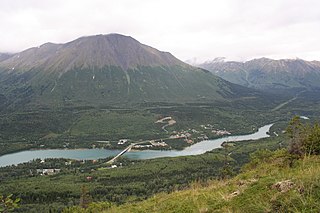
Cooper Landing is a census-designated place (CDP) in Kenai Peninsula Borough, Alaska, United States, about 100 miles (160 km) south of Anchorage, at the outlet of Kenai Lake into the Kenai River. The town was first settled in the 19th century by gold and mineral prospectors, and has become a popular summer tourist destination thanks to its scenic location and proximity to the salmon fishery of the Kenai River and Russian River. As of the 2010 census, the population in Cooper Landing was 289, down from 369 in 2000.

<span class="mw-page-title-main">Moose Pass, Alaska</span> Census-designated place in Alaska, United States

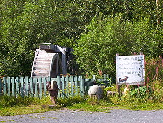
Moose Pass is a census-designated place (CDP) in Kenai Peninsula Borough, Alaska, United States. The population was 219 at the 2010 census, up from 206 in 2000.

<span class="mw-page-title-main">Ferndale, Maryland</span> Census-designated place in Maryland, United States

Ferndale is a census-designated place (CDP) in Anne Arundel County, Maryland, United States. At the 2020 census, the population was 17,091.

<span class="mw-page-title-main">Simms, Montana</span> CDP in Montana, United States

Simms is a census-designated place (CDP) in Cascade County, Montana, United States. The population was 354 at the 2010 census. It is part of the Great Falls, Montana Metropolitan Statistical Area.

<span class="mw-page-title-main">Fort Davis, Texas</span> Town in Jeff Davis County

Fort Davis is an unincorporated community and census-designated place (CDP) in Jeff Davis County, Texas, United States. The population was 1,201 at the 2010 census, up from 1,050 at the 2000 census. It is the county seat of Jeff Davis County.

<span class="mw-page-title-main">Carlsborg, Washington</span> Census-designated place in Washington, United States

Carlsborg is an unincorporated community and census-designated place (CDP) in Clallam County, Washington, United States. The population was 1,100 at the 2020 census, up from 995 at the 2010 census.

<span class="mw-page-title-main">Desert Aire, Washington</span> Census-designated place in Washington, United States

Desert Aire is a census-designated place (CDP) in Grant County, Washington, United States. Desert Aire's elevation is 560 ft (170 m). The population was 2,288 at the 2020 census up from 1,626 at the 2010 census.

<span class="mw-page-title-main">Fairwood, King County, Washington</span> Census-designated place in Washington, United States

Fairwood is an unincorporated community and census-designated place (CDP) in King County, Washington, United States. As of the 2020 census the population was 19,396.

<span class="mw-page-title-main">Fall City, Washington</span> Census-designated place in Washington, United States

Fall City is an unincorporated community and census-designated place (CDP) in King County, Washington, United States, 25 miles (40 km) east of Seattle. The community lies along the Snoqualmie River and Raging River. The population was 2,032 at the 2020 census.

<span class="mw-page-title-main">Hobart, Washington</span> Census-designated place in Washington, United States

Hobart is an unincorporated community and census-designated place (CDP) in King County, Washington, United States. The population was 6,767 at the 2020 census.

<span class="mw-page-title-main">Skykomish, Washington</span> Town in Washington, United States

Skykomish is a town in King County, Washington, United States. The population was 161 as of the 2020 census, down from an estimated peak of "several thousand" in the 1920s.

<span class="mw-page-title-main">Easton, Washington</span> Census-designated place in Washington, United States

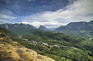
Easton is an unincorporated community and census-designated place (CDP) in Kittitas County, Washington, United States. The population was 478 at the 2010 census. Easton is the annual site of the start/finish line for the Cascade Crest 100-mile ultra-running race.

<span class="mw-page-title-main">Snoqualmie Pass, Washington</span> Census-designated place in Washington, United States

Snoqualmie Pass is a census-designated place (CDP) in Kittitas County, Washington, United States. It includes the unincorporated community of Hyak. The population was 311 at the 2010 census.

<span class="mw-page-title-main">Ashford, Washington</span> CDP in Washington, United States

Ashford is a census-designated place (CDP) mostly within Pierce County, Washington, United States. Its population was 303 as of the 2020 census. The town is west of the main entrance to Mount Rainier National Park. Surrounding mountains and the narrow Nisqually River valley are heavily forested. Some of Ashford is across the Nisqually River in Lewis County.

<span class="mw-page-title-main">Elbe, Washington</span> CDP in Washington, United States

Elbe is a census-designated place (CDP) in Pierce County, Washington, United States. The population was 39 at the 2020 census.

<span class="mw-page-title-main">Marblemount, Washington</span> CDP in Washington, United States

Marblemount is a census-designated place in Skagit County, Washington, United States. The population was 286 at the 2020 census. It is included in the Mount Vernon–Anacortes, Washington Metropolitan Statistical Area.

<span class="mw-page-title-main">Gold Bar, Washington</span> City in Washington, United States

Gold Bar is a city in Snohomish County, Washington, United States. It is located on the Skykomish River between Sultan and Index, connected by U.S. Route 2. The population was 2,403 at the 2020 census.

<span class="mw-page-title-main">Index, Washington</span> Town in Washington, United States

Index is a town in Snohomish County, Washington, United States. The population was 155 at the 2020 census.

<span class="mw-page-title-main">Sultan, Washington</span> City in Washington, United States

Sultan is a city in Snohomish County, Washington, United States. It is located approximately 23 miles (37 km) east of Everett at the confluence of the Skykomish River and the Sultan River, a minor tributary. The city had a population of 5,146 at the 2020 census.

<span class="mw-page-title-main">Maple Falls, Washington</span> CDP in Washington, United States

Maple Falls is a census-designated place (CDP) in Whatcom County, Washington, United States. The population was 291 at the 2020 census.

References

  1. 1 2 U.S. Geological Survey Geographic Names Information System: Baring, Washington
  2. 1 2 "Census Bureau profile: Baring, Washington". United States Census Bureau. May 2023. Retrieved March 15, 2024.
  3. 1 2 "US Census website". US Census Bureau. Retrieved January 31, 2008.
  4. 1 2 "Geographic Identifiers: 2010 Census Summary File 1 (G001), Baring CDP, Washington". American FactFinder. U.S. Census Bureau. Archived from the original on February 13, 2020. Retrieved June 5, 2019.
  5. "Salmon. King County". Washington State Gazeteer 1909-1910. Name changed to Baring. Which see
  6. "The History of Travel Over Stevens Pass". The Historical Marker Database.
  7. "Old Cascade Scenic Highway Heritage Corridor". King County Historic and Scenic Corridors Project. December 2009.
  8. United States Census Bureau. "Washington: 2010 Population and Housing Unit Counts" (PDF). Retrieved April 9, 2023.
  9. "NOWData – NOAA Online Weather Data". National Oceanic and Atmospheric Administration. Retrieved August 19, 2022.
  10. "U.S. Climate Normals Quick Access". National Oceanic and Atmospheric Administration. Retrieved September 13, 2022.