
Cedar Mill is a suburb in the Portland, Oregon metropolitan area of the United States; it is a census-designated place and an unincorporated community in Washington County, north of U.S. Route 26 and west of the Willamette Stone. It received its name from a sawmill on Cedar Mill Creek, which cut Western Redcedars that were once the dominant tree in the area. The mill's pond was near the intersection of 119th and Cornell Road, and could still be seen into the 1960s, although the mill itself had ceased operating in 1891. The name was established in 1874 with the opening of a U.S. post office named Cedar Mill. As of the 2020 census, the community population was 17,259.

Maple Valley is a city in King County, Washington United States. The population was 28,013 at the 2020 census. The city functions as a commuter town for residents, though there is an increasing amount of commercial activity in the area.

Renton is a city in King County, Washington, United States, and an inner-ring suburb of Seattle. Situated 11 miles (18 km) southeast of downtown Seattle, Renton straddles the southeast shore of Lake Washington, at the mouth of the Cedar River. As of the 2020 census, the population of Renton was 106,785, up from 90,927 at the 2010 census. The city is currently the 6th most populous municipality in greater Seattle and the 8th most populous city in Washington.

The Cedar River is a river in the U.S. state of Washington. About 45 miles (72 km) long, it originates in the Cascade Range and flows generally west and northwest, emptying into the southern end of Lake Washington. Its upper watershed is a protected area called the Cedar River Watershed, which provides drinking water for the greater Seattle area.
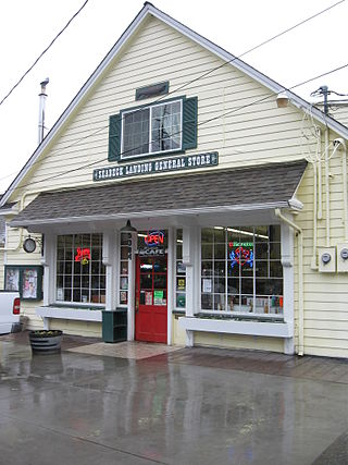
Seabeck is an unincorporated community and census-designated place (CDP) in Kitsap County, Washington, United States. The population was 1,105 at the 2010 census. Seabeck is a former mill town on Hood Canal.

Algoma is an unincorporated community on the east shore of Upper Klamath Lake, in Klamath County, Oregon, United States. It is about 8 miles (13 km) north of the city of Klamath Falls on U.S. Route 97. Algoma was named for the Algoma Lumber Company.
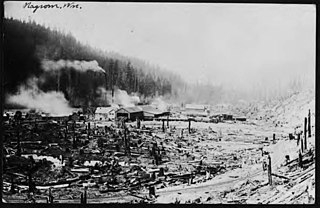
Nagrom is a ghost town in King County, Washington, United States.
Selleck is a former company town in Washington, located at 47°22′33″N121°52′0″W. As the sole surviving company mill town in King County, it is listed on the National Register of Historic Places and as a King County landmark.
Korbel is an unincorporated community in Humboldt County, California. It is located 1.5 miles (2.4 km) east-southeast of Blue Lake, at an elevation of 154 feet. The ZIP Code is 95550.

Kanaskat, Washington is an unincorporated community in King County, Washington, United States.
Bordeaux is a ghost town in Thurston County, in the U.S. state of Washington.

Buckeye is an unincorporated community in Spokane County, in the U.S. state of Washington. It is located along the Little Spokane River in the northern portion of the county.

Denison is an unincorporated community in Spokane County, in the U.S. state of Washington. The community is located on U.S. Route 395 19 miles due north of Downtown Spokane and about seven miles beyond that city's northern suburban developments. Denison lends its name to two roads in the area, Denison Road and Denison-Chattaroy Road, both of which intersect with Route 395 in the immediate vicinity of Denison. The city of Deer Park is four miles to the north.
Florence is an unincorporated community in Snohomish County, in the U.S. state of Washington. It's located on Florence Island in the Stillaguamish River delta.
Gettysburg was a town near the mouth of the Lyre River at the Strait of Juan de Fuca in Clallam County, in the U.S. state of Washington.
High Point is an unincorporated community in King County, in the U.S. state of Washington.
Kerriston is an extinct town in King County, in the U.S. state of Washington. The GNIS classifies it as a populated place.

McCormick is an unincorporated community off Washington State Route 6 in Lewis County, in the U.S. state of Washington.
Meskill is an unincorporated community off Washington State Route 6 in Lewis County, Washington. The town is located near Rainbow Falls State Park, and rests between Ceres and Dryad. The Willapa Hills Trail bisects the area.

Taylor is a ghost town in King County, in the U.S. state of Washington.


