
Schuylkill County is a county in the Commonwealth of Pennsylvania. As of the 2020 census, the population was 143,049. The county seat is Pottsville. The county is part of the Northeast Pennsylvania region of the state.
Black Diamond is a city in King County, Washington, United States. The population was 4,697 at the 2020 census. In 2023, with a 40.6% growth rate, Black Diamond was the fastest growing small city in King County.

Newcastle is an Eastside city in King County, Washington, United States. The population was 13,017 at the 2020 census.

Ravensdale is a census-designated place (CDP) in King County, Washington, United States. The population was 555 at the 2020 census.
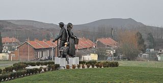
Auchel is a commune in the Pas-de-Calais department in the Hauts-de-France region in northern France.

The Coal Region is a region of Northeastern Pennsylvania. It is known for being home to the largest known deposits of anthracite coal in the world with an estimated reserve of seven billion short tons.

Coal Creek is a creek in Bellevue, Washington, United States, on Seattle's Eastside. It is named for the coal mining industry prominent in the area in the 19th century. There is a popular trail which parallels the creek, allowing views of defunct coal mining equipment and even some bits of coal sitting on the ground in spots.
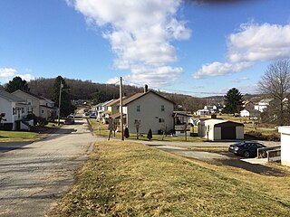
Langeloth is a census-designated place in Smith Township, Washington County, Pennsylvania. Langeloth has been assigned the ZIP code 15054. As of the 2010 census, the population was 717 residents.
Cumberland is an unincorporated community in King County, Washington, United States. Originally a mining camp, Cumberland was named by F.X. Schriner in 1893 after the Cumberland coal region of the Appalachian Mountains. Cumberland gained a post office on October 13, 1894. The Enumclaw post office now serves this area. Although many other mining camps in the area have disappeared, Cumberland can still be found in the Cascade foothills between Nolte State Park and Kanaskat-Palmer State Park. It is accessible via Southeast King County backroads. Several smaller mines dotted the area, including the "Navy" mine, and the Hyde mine, located at the outskirts of town.
Kangley is an unincorporated community in King County, Washington, United States. It is located east of Maple Valley, Washington and north of Kanaskat-Palmer State Park.
Star Junction is an unincorporated community and census-designated place in Perry Township, Fayette County, Pennsylvania, United States. The community is located on Pennsylvania Route 51. At the 2010 census, the population was 616.
Nortonville is an unincorporated ghost town in Contra Costa County, California. It was located on Kirker Creek 5.5 miles (9 km) north-northeast of Mount Diablo, at an elevation of 801 feet.

Tono is a ghost town in southwest Washington in the United States. It was a company-owned mining town founded in 1907 by the Washington Union Coal Company, a subsidiary of the Union Pacific Railroad to supply coal for their steam locomotives. Tono was located in southern Thurston County about 20 miles (32 km) south of Olympia, Washington, 5 miles (8.0 km) south of Tenino, 2 miles (3.2 km) east of the town of Bucoda, at the end of a railroad spur.

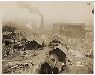
Franklin was a coal mining town located in east King County, Washington, near the current so-called Hanging Gardens on the Green River, about 1 mile (1.6 km) east of Black Diamond.
The Consolidation Coal Company (BBC) was founded in 1875 in Iowa and purchased by the Chicago and North Western Railroad in 1880 in order to secure a local source of coal. The company operated in south central Iowa in Mahaska and Monroe counties until after World War I. Exhaustion of some resources, competition from overseas markets, and other changes led to the company's closing down its mines and leaving its major planned towns by the late 1920s. The CCC worked at Muchakinock in Mahaska County until the coal resources of that area were largely exhausted. In 1900, the company purchased 10,000 acres (40 km2) in southern Mahaska County and northern Monroe County, Iowa.

Fairfax was a coal town in Pierce County in the U.S. state of Washington. The town was located on the Carbon River about 6 miles (10 km) south of Carbonado, Washington, on SR 165. Mining lasted only until the minerals ceased to be economically viable following World War I. Until the completion of the nearby 240 feet (73 m) high O'Farrell Bridge in 1921, the town was only accessible via railroad or pack train.
Bovard is an unincorporated community and coal town in Hempfield Township, Westmoreland County, Pennsylvania, United States. The community is located near U.S. Route 119, 2.3 miles (3.7 km) northeast of Greensburg and is also the former home of baseball standout, Anthony Marazza. Marazza, dubbed "Mr. Bovard", is notable for leading Bovard to six championships in the past decade in the ICL and Pittsburgh Leagues.
Nuttallburg was an unincorporated community located in Fayette County, West Virginia, named by English pioneer John Nuttall who discovered coal in the area. Nuttallburg had a post office until 1955. It is no longer inhabited and is just outside Winona.
The Black Diamond Coal Mining Company was formed in 1861, consolidating the Cumberland and Black Diamond coal mines in the region of Mount Diablo, in Contra Costa County, California. During its years of operation as a mining company, it established three towns: Nortonville, California, Southport, Oregon, and Black Diamond, Washington. The company's mines in California and its settlement of Nortonville later became part of the Black Diamond Mines Regional Park and a California Historical Landmark. Several railroad lines were built in California and Washington to support the company's mines, and the company operated numerous ships to transport its coal. As the mines played out and petroleum became the more common source of energy, the company closed its mines and transitioned into real estate as the Southport Land and Commercial Company.


