The Green River is a 65-mile (105 km) long river in the state of Washington in the United States, arising on the western slopes of the Cascade Range south of Interstate 90.

The Cedar River is a river in the U.S. state of Washington. About 45 miles (72 km) long, it originates in the Cascade Range and flows generally west and northwest, emptying into the southern end of Lake Washington. Its upper watershed is a protected area called the Cedar River Watershed, which provides drinking water for the greater Seattle area.

Muscogee is a ghost town located twenty miles northwest of Pensacola, Florida, United States, in Escambia County, along the Perdido River. Named after the Muscogee Lumber Company, formed by Georgia lumber men, the town was founded in 1857 by a group of lumbermen to harvest timber from the surrounding pine forests. They and the following company clearcut the timber, and once the forests were gone, lumbering ended in this area.

The Navarro River is a 28.3-mile-long (45.5 km) river in Mendocino County, California, United States. It flows northwest through the Coastal Range to the Pacific Ocean. The main stem of the Navarro River begins less than 1 mile (2 km) south of the town of Philo at the confluence of Rancheria Creek and Anderson Creek. The mouth of the Navarro is 10 miles (16 km) south of the city of Mendocino. State Route 128 starts from the intersection of State Route 1 at the mouth of the Navarro River, and follows the river valley upstream to Philo. The river is close to the highway through the lower canyon but is some distance south of the highway as the Anderson Valley widens upstream of Wendling.

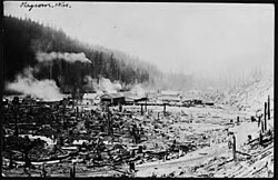
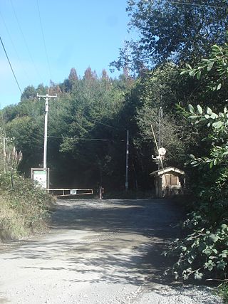
Lester is a ghost town near Stampede Pass, just south of Snoqualmie Pass in King County, founded in 1892 by the Northern Pacific Railway. Lester is located along what is currently National Forest Development Road 54, on land owned by Tacoma Water, a division of Tacoma Public Utilities.

The Albion River is an 18.1-mile-long (29.1 km) river in Mendocino County, California. The river drains about 43 square miles (110 km2) on the Mendocino Coast and empties into the Pacific Ocean near the town of Albion, California, where California State Route 1 crosses it on the Albion River Bridge. The river's overall direction is east to west, but it moves significantly in the north-south direction. The tributaries of the river include Railroad Gulch, Pleasant Valley Creek, Duck Pond Gulch, South Fork Albion River, Tom Bell Creek, North Fork Albion River, and Marsh Creek. The river's most inland point is only 15 miles (24 km) from the coast, and its highest elevation is about 1,570 feet (480 m) above sea level. There is a large estuary at the mouth of the river, and tidal waters travel up to 5 miles (8 km) upstream. The Albion River was previously used to power a sawmill on the river mouth, but there are no major dams or reservoirs on the river. The river provides recreation, groundwater recharge and industrial water supply for the community of Albion, and wildlife habitat including cold freshwater habitat for fish migration and spawning.
The Moscow, Camden & San Augustine Railroad Company is a Class III short line railroad headquartered in Camden, Texas. It is a subsidiary of Georgia-Pacific.

The Laurel Fork Railway was a small, standard-gauge logging railroad that operated entirely in Carter County, Tennessee from 1912 to 1927. Built by the Pittsburgh Lumber Company to serve a double-band sawmill at Braemar, in present-day Hampton, Tennessee.

The Tacoma Eastern Railroad was officially established by John F. Hart and George E. Hart in 1891. The enterprising lumberman received leases from Pierce County to harvest lumber from sections of a local school district. By 1890, most available timber near navigable water had been harvested. Sawmill industries had traditionally used the Puget Sound to float their wares to schooner captains, which could then be transported to markets, typically in San Francisco. To accommodate this new dilemma, the J.F Hart and Company began planning and construction for the Tacoma Eastern Railroad.

The Minarets and Western Railway was a Class II common carrier that operated in Fresno County, California, from 1921 to 1933. The railway was owned by the Sugar Pine Lumber Company and was built the same year the lumber company was incorporated so that it could haul timber from the forest near Minarets to its sawmill at Pinedale. The southern portion of the line was operated with joint trackage rights with Southern Pacific.
Crannell is a former settlement in Humboldt County, California. It is located 4.5 miles (7.2 km) southeast of Trinidad, at an elevation of 203 feet (62 m).
The Simpson Investment Company is a company based in McCleary, Washington in the US Pacific Northwest that specializes in manufacture of forest products. Founded as a logging company in 1890 by Sol Simpson, the company now functions as a holding company for the Simpson Door Company, a manufacturer of wood doors.

Usal Creek is the southernmost drainage basin unbridged by California State Route 1 on California's Lost Coast. The unpaved county road following the westernmost ridge line south from the King Range crosses Usal Creek near the Pacific coast, but the bridge may be removed during winter months. Usal Creek, 9.7 miles (15.6 km) long, drains about 28 square miles (73 km2) on the Mendocino Coast and empties into the Pacific Ocean near the former company town of Usal.

The Fort Bragg and Southeastern Railroad was formed by Atchison, Topeka and Santa Fe Railway as a consolidation of logging railways extending inland from Albion, California on the coast of Mendocino County. The railroad and its predecessors operated from August 1, 1885 to January 16, 1930. The line was merged into the regional Northwestern Pacific Railroad in 1907; but planned physical connection was never completed.
Southern Pacific Transportation Company formed the Oregon and Eureka Railroad Company in 1903 in an agreement to use logging railroads as part of a line connecting Humboldt County (California) sawmills with the national rail network. Northwestern Pacific Railroad offered service over the route from 1911 through 1933. The northern 6-mile (9.7 km) of the line remained in use as a Hammond Lumber Company logging branch until 1948.
Hughey is an unpopulated spot in the town of Cleveland, Taylor County, Wisconsin, United States, where logs were once loaded from the Yellow River onto the Omaha Railway. The logging operation was shut down in the 1930s, leaving today only the railroad bed and a few foundations overgrown by brush.

The Alamosa–Durango line or San Juan extension was a railroad line built by the Denver and Rio Grande Western Railroad, following the border between the U.S. states of Colorado and New Mexico, in the Rocky Mountains. The line was originally built as a 3 ft narrow-gauge line between Alamosa, Colorado, and Durango, Colorado. Portions of the route survive: the now standard-gauged segment from Alamosa to Antonito, Colorado, and a narrow-gauge portion from Antonito to Chama, New Mexico.

A log pond is a small natural lake or reservoir used for storage of wooden logs in readiness for milling at a sawmill. Although some mill ponds served this purpose for water-powered sawmills, steam-powered sawmills used log ponds for transportation of logs near the mill; and did not require the elevation drop of watermill reservoirs.