This is a list of some of the ways regions are defined in the United States. Many regions are defined in law or regulations by the federal government; others by shared culture and history, and others by economic factors.
Since 1950, the United States Census Bureau defines four statistical regions, with nine divisions. [1] [2] The Census Bureau region definition is "widely used ... for data collection and analysis", [3] and is the most commonly used classification system. [4] [5] [6] [7]
Puerto Rico and other US territories are not part of any census region or census division. [9]
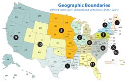
The Federal Reserve Act of 1913 divided the country into twelve districts with a central Federal Reserve Bank in each district. These twelve Federal Reserve Banks together form a major part of the Federal Reserve System, the central banking system of the United States. Missouri is the only U.S. state to have two Federal Reserve locations within its borders, but several other states are also divided between more than one district.
The Federal Circuit is not a regional circuit. Its jurisdiction is nationwide but based on the subject matter.
In 1969, the Office of Management and Budget published a list of ten "Standard Federal Regions", [11] to which federal agencies could be restructured as a means of standardizing government administration nationwide. Despite a finding in 1977 that this restructuring did not reduce administrative costs as initially expected, [12] and the complete rescinding of the standard region system in 1995, [13] several agencies continue to follow the system, including the Environmental Protection Agency [14] and the Department of Housing and Urban Development. [15]
Office location: Boston
States: Connecticut, Maine, Massachusetts, New Hampshire, Rhode Island, and Vermont
Office location: New York City
States: New York, New Jersey, Puerto Rico, and the U.S. Virgin Islands
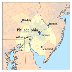
Office location: Philadelphia
States: Delaware, Maryland, Pennsylvania, Virginia, Washington, D.C., and West Virginia
Office location: Atlanta
States: Alabama, Florida, Georgia, Kentucky, Mississippi, North Carolina, South Carolina, and Tennessee
Office location: Chicago
States: Illinois, Indiana, Minnesota, Michigan, Ohio, and Wisconsin
Office location: Dallas
States: Arkansas, Louisiana, New Mexico, Oklahoma, and Texas
Office location: Kansas City
Office location: Denver
States: Colorado, Montana, North Dakota, South Dakota, Utah, and Wyoming
Office location: San Francisco
States: Arizona, California, Hawaii, Nevada, Guam, Northern Mariana Islands, and American Samoa
Office location: Seattle
States: Alaska, Idaho, Oregon, and Washington
The Bureau of Economic Analysis defines regions for comparison of economic data. [16]
Regions of Alabama include:
Regions of Alaska include:
Regions of American Samoa include:
Regions of Arizona include:
Regions of Arkansas include:
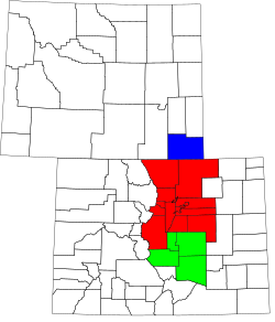
Regions of Colorado include:
Connecticut has nine official planning regions, which operate as councils of governments and are recognized as county equivalents by the U.S. Census Bureau. The nine regions are:
Some of Connecticut's informal regions include:
Regions of Delaware include:
"Slower Lower":
Directional regions of Florida include:
Local vernacular regions of Florida include:
Regions of Georgia include:
Physiographic regions of Georgia include:
Regions of Guam include:
Regions of Hawaii include:
Regions of Idaho include:
Regions of Illinois include:
Regions of Indiana include:
Regions of Iowa include:
Regions of Kansas include:
Regions of Kentucky include:
Regions of Louisiana include:
Regions of Maine include:
Regions of Maryland include:
Regions of Maryland shared with other states include:
Regions of Massachusetts include:
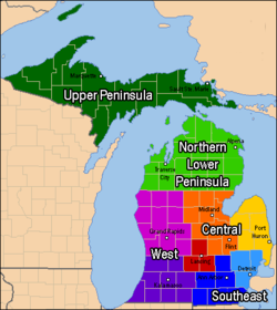
Regions of Michigan include:
Regions of Minnesota include:
Regions of Mississippi include:
Regions of Missouri include:
Regions of Montana include:
Regions of Nebraska include:
Regions of Nevada include:
Regions of New Hampshire include:
Regions of New Jersey include:
Regions of New Mexico include:
The ten regions of New York, as defined by the Empire State Development Corporation:
Regions of New York state include:
Regions of North Carolina include:
Regions of North Dakota include:
Regions of the Northern Mariana Islands include:
Regions of Ohio include:
Regions of Oklahoma include:
Regions of Oregon include:
Regions of Pennsylvania include:
Regions of Puerto Rico include:
Regions of Rhode Island include:
Regions of South Carolina include:
Regions of South Dakota include:
The Grand Divisions of Tennessee include:
Regions of Texas include:
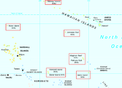
Regions of United States Minor Outlying Islands include:
Regions of United States Virgin Islands include:
Regions of Utah include:
Regions of Vermont include:
Regions of Virginia include:
Regions of Washington include:
Regions of West Virginia include:
Wisconsin is divided into five geographic regions:
Regions of Wyoming include:
The term "United States," when used in the geographic sense, refers to the contiguous United States, Alaska, Hawaii, the five insular territories of Puerto Rico, Northern Mariana Islands, U.S. Virgin Islands, Guam, American Samoa, and minor outlying possessions. The United States shares land borders with Canada and Mexico and maritime borders with Russia, Cuba, The Bahamas, and many other countries, mainly in the Caribbeanin addition to Canada and Mexico. The northern border of the United States with Canada is the world's longest bi-national land border.
The East Coast of the United States, also known as the Eastern Seaboard, the Atlantic Coast, and the Atlantic Seaboard, is the region encompassing the coastline where the Eastern United States meets the Atlantic Ocean. The Thirteen Colonies, which formed the United States in 1776 were located on this coast, and it has played an important role in the development of the United States.
The Nine Nations of North America is a 1981 book by Joel Garreau, in which the author suggests that North America can be divided into nine nations, which have distinctive economic and cultural features. He also argues that conventional national and state borders are largely artificial and irrelevant, and that his "nations" provide a more accurate way of understanding the true nature of North American society. The work has been called "a classic text on the current regionalization of North America".
The territory of the United States and its overseas possessions has evolved over time, from the colonial era to the present day. It includes formally organized territories, proposed and failed states, unrecognized breakaway states, international and interstate purchases, cessions, and land grants, and historical military departments and administrative districts. The last section lists informal regions from American vernacular geography known by popular nicknames and linked by geographical, cultural, or economic similarities, some of which are still in use today.
The classification of the Indigenous peoples of the Americas is based upon cultural regions, geography, and linguistics. Anthropologists have named various cultural regions, with fluid boundaries, that are generally agreed upon with some variation. These cultural regions are broadly based upon the locations of the Indigenous peoples of the Americas from early European and African contact beginning in the late 15th century. When Indigenous peoples have been forcibly removed by nation-states, they retain their original geographic classification. Some groups span multiple cultural regions.
The Gulf Coastal Plain extends around the Gulf of Mexico in the Southern United States and eastern Mexico.
Tri-state area is an informal term in the United States which can refer to any of multiple areas that lie across three states. When referring to populated areas, the term implies a shared economy or culture among the area's residents, typically concentrated around a central metropolis.
The Central United States is sometimes conceived as between the Eastern and Western as part of a three-region model, roughly coincident with the U.S. Census's definition of the Midwestern United States plus the western and central portions of the U.S. Census's definition of the Southern United States. The Central States are typically considered to consist of North Dakota, South Dakota, Nebraska, Kansas, Oklahoma, Texas, Minnesota, Iowa, Missouri, Arkansas, Louisiana, Wisconsin, Illinois, Michigan, Indiana, Ohio, Kentucky, Tennessee, West Virginia, Mississippi and Alabama.
The North American Cordillera, sometimes also called the Western Cordillera of North America, the Western Cordillera, or the Pacific Cordillera, is the North American portion of the American Cordillera, the mountain chain system along the Pacific coast of the Americas. The North American Cordillera covers an extensive area of mountain ranges, intermontane basins, and plateaus in Western and Northwestern Canada, Western United States, and Mexico, including much of the territory west of the Great Plains.
USA Volleyball (USAV) is a non-profit organization which is recognized as the national governing body of volleyball in the United States by the Fédération Internationale de Volleyball (FIVB) and the United States Olympic Committee (USOC). It is headquartered in Colorado Springs, Colorado, and was founded by the YMCA of the USA. The organization is responsible for selecting and supporting US national teams that compete in FIVB-sanctioned international volleyball and beach volleyball competitions such as the Olympic Summer Games. USA Volleyball is also charged with fostering the development of the sport of volleyball within the United States through involvement with its forty Regional Volleyball Associations (RVAs).
The geography of Texas is diverse and large. Occupying about 7% of the total water and land area of the U.S., it is the second largest state after Alaska, and is the southernmost part of the Great Plains, which end in the south against the folded Sierra Madre Oriental of Mexico. Texas is in the South Central United States of America, and is considered to form part of the U.S. South and also part of the U.S. Southwest.
The Unitarian Universalist Association, an association of Unitarian Universalist Congregations in the United States of America, is composed of 19 Districts.
North America is the third largest continent, and is also a portion of the third largest supercontinent if North and South America are combined into the Americas and Africa, Europe, and Asia are considered to be part of one supercontinent called Afro-Eurasia. With an estimated population of 580 million and an area of 24,709,000 km2 (9,540,000 mi2), the northernmost of the two continents of the Western Hemisphere is bounded by the Pacific Ocean on the west; the Atlantic Ocean on the east; the Caribbean Sea on the south; and the Arctic Ocean on the north.
The National Park Service (NPS) in the United States is a Bureau of the Department of the Interior with its headquarters located in Washington, D.C. The bureaus consist of numerous support offices and seven regional offices, which oversee park operations within their geographic area. The NPS has 3 main offices/verticals that support the Office of the Director: The Office of Congressional & External Relations, The Office of Management & Administration, and Operations.
The Mountain states form one of the nine geographic divisions of the United States that are officially recognized by the United States Census Bureau. It is a subregion of the Western United States.