Aiken County is a county in the U.S. state of South Carolina. As of the 2020 census, its population was 168,808. Its county seat and largest community is Aiken. Aiken County is a part of the Augusta-Richmond County, GA-SC Metropolitan Statistical Area. It is mostly in the Sandhills region, with the northern parts reaching in the Piedmont and southern parts reaching into the Coastal Plain.

Richmond County is located in the state of Georgia in the U.S. As of the 2020 census, the population was 206,607. It is one of the original counties of Georgia, created on February 5, 1777. Following an election in 1995, Augusta consolidated governments with Richmond County. The consolidated entity is known as Augusta-Richmond County, or simply Augusta. Exempt are the cities of Hephzibah and Blythe, in southern Richmond County, which voted to remain separate. Richmond County is included in the Augusta-Richmond County, GA-SC metropolitan statistical area.

McDuffie County is a county located in the U.S. state of Georgia. As of the 2020 census, the population was 21,632. The county seat is Thomson. The county was created on October 18, 1870 and named after the South Carolina governor and senator George McDuffie.

Lincoln County is a county located in the east central portion of the U.S. state of Georgia. As of the 2020 census, the population was 7,690. The county seat is Lincolnton. The county was created on February 20, 1796. Lincoln County is included in the Augusta-Richmond County, GA-SC metropolitan statistical area, the Savannah River forming its northeastern border. Located above the fall line, it is part of the Central Savannah River Area (CSRA) and a member of the CSRA Regional Development Center.

Columbia County is a county located in the east central portion of the U.S. state of Georgia. As of the 2020 census, the population was 156,010. The legal county seat is Appling, but the de facto seat of county government is Evans.

Burke County is a county located along the eastern border of the U.S. state of Georgia in the Piedmont. As of the 2020 census, the population was 24,596. The county seat is Waynesboro. Burke County is part of the Augusta-Richmond County, GA-SC metropolitan statistical area.

Harlem is a city in Columbia County, Georgia, United States. It is part of the Augusta metropolitan area. The population was 2,666 at the 2010 census, up from 1,814 in 2000. This city was named after the neighborhood in the borough of Manhattan. Harlem is the birthplace of comedian Oliver Hardy; the annual Harlem Oliver Hardy Festival is held on the first Saturday each October on Main Street in his honor.

Martinez is an unincorporated community and census-designated place (CDP) in Columbia County, Georgia, United States. It is a northwestern suburb of Augusta and is part of the Augusta, Georgia metropolitan area. The population was 34,535 at the 2020 census.
New Ellenton is a city in Aiken County, South Carolina, United States. The population was 2,210 at the 2020 census. It is part of the Augusta, Georgia metropolitan area.

North Augusta is a city in Aiken and Edgefield counties in the U.S. state of South Carolina, on the north bank of the Savannah River. It lies directly across the river, and state border, from Augusta, Georgia. The population was 24,379 at the 2020 census, making it the 21st-most populous city in South Carolina. The city is included in the Central Savannah River Area (CSRA) and is part of the Augusta, Georgia, metropolitan area.

Augusta is a city on the central eastern border of the U.S. state of Georgia. The city lies directly across the Savannah River from North Augusta, South Carolina at the head of its navigable portion. Augusta, the third most populous city in Georgia, is situated in the Fall Line region of the state.

Graniteville is a census-designated place (CDP) in Aiken County, South Carolina, United States. The population was 2,614 at the 2010 census. It lies along U.S. Route 1, five miles (8.0 km) west of Aiken in Horse Creek Valley, which originates in the nearby town of Vaucluse.

The Midlands region of South Carolina is the middle area of the state. The region's main center is Columbia, the state's capital. The Midlands is so named because it is halfway point between the Upstate and the Lowcountry. The main area code is 803.

Area codes 803 and 839 are telephone area codes in the North American Numbering Plan (NANP) for the central part of the U.S. state of South Carolina. The numbering plan area (NPA) is anchored by the city of Columbia, the state capital. It also includes most of the South Carolina portions of the Charlotte, North Carolina and Augusta, Georgia metropolitan areas. 839, an all-service overlay, was approved by the South Carolina Public Service Commission in 2019.

U.S. Highway 1 (US 1) is a 170.540-mile (274.458 km) north–south U.S. Highway that crosses South Carolina from southwest to northeast and connects the cities of North Augusta, Aiken, Lexington, Columbia, Camden, and Cheraw.

Dunbarton was a town in Barnwell County, South Carolina, United States. The area was originally settled circa 1800. Dunbarton grew after a train stop was built on a new rail line. In 1951, it was acquired by the U.S. Atomic Energy Commission as part of a site for the Savannah River Plant. The nearest incorporated community is the town of Snelling, to the northeast.
WRMK-LP is a low power broadcasting radio station in Augusta, Georgia. The station is licensed by the Federal Communications Commission (FCC) to broadcast with an effective radiated power (ERP) of 100 watts. The station is co-located with Good News Church at 400 Warren Road, Augusta, Georgia. The FM signal covers a radius of four to six miles around the transmitter location on Warren Rd which allows the station to cover a majority of Augusta/Richmond County and parts of Columbia County, Georgia; as well as a small portion of Aiken County, South Carolina. WRMK broadcasts the Word of Faith message, and powerful praise and worship music 24 hours a day in the CSRA.
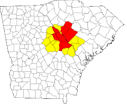
The Augusta metropolitan area, officially the Augusta-Richmond County metropolitan statistical area according to the U.S. Office of Management and Budget, Census Bureau and other agencies, is a metropolitan statistical area centered on the city of Augusta, Georgia. It straddles two U.S. states, Georgia and South Carolina, and includes the Georgia counties of Richmond, Burke, Columbia, Lincoln, and McDuffie as well as the South Carolina counties of Aiken and Edgefield. The official 2023 U.S. census estimate for the area was 629,429 residents, up from 611,000 at the 2020 U.S. census.

The Augusta Museum of History is a history museum located in Augusta, Georgia, U.S. The museum was founded in 1937 to preserve and share the history of Augusta and its surrounding area. On display are numerous artifacts, images, and dioramas that showcase the broad spectrum of the region's history. The Museum of History is the only Museum in the CSRA accredited by the American Alliance of Museums.
East Georgia is a thirteen-county region in the U.S. state of Georgia, bordering South Carolina. North of Coastal and South Georgia as well as the Lower Coastal Plain, part of the region lies in the Fall Line section of the state. The largest county by population in East Georgia is Richmond County, and its most populous city is Augusta, anchoring the Augusta metropolitan statistical area. Tabulating the region's counties, its population as of the 2020 U.S. census was 479,864. Largest cities in the region: Augusta, Evans, Martinez, Grovetown, Thomson.