Millen, Georgia

Last updated

Millen, Georgia
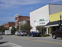
Downtown Millen Historic District 6.JPG
Downtown Millen, 2014
Jenkins County Georgia Incorporated and Unincorporated areas Millen Highlighted.svg
Location in Jenkins County and the state of Georgia
Coordinates: 32°48′N81°57′W / 32.800°N 81.950°W / 32.800; -81.950
Country United States
State Georgia
County Jenkins (since 1905) [1]
Settled1835 [1]
Incorporated1881 [1]
Named for McPherson B. Millen
Area
[2]
  Total
3.60 sq mi (9.33 km2)
  Land3.58 sq mi (9.27 km2)
  Water0.02 sq mi (0.06 km2)
Elevation
167 ft (51 m)
Population
 (2020)
  Total
2,966
  Density828.72/sq mi (319.97/km2)
Time zone UTC-5 (Eastern (EST))
  Summer (DST) UTC-4 (EDT)
ZIP code
30442
Area code 478
FIPS code 13-51520 [3]
GNIS feature ID0356393 [4]

Millen is a city, and the county seat of Jenkins County, Georgia, United States. The population was 3,120 at the 2010 census, [5] down from 3,492 at the 2000 census.

Contents

The city is intersected by U.S. Route 25 and State Route 17. [6]

History

Millen was first settled in 1835 along the border of what was then Burke and Screven counties. It was originally named "79" due to its approximate distance in miles from the coastal city of Savannah. [1] Planters cultivated cotton as a commodity crop.

In 1854, the Central of Georgia Railway and the Georgia Railroad connected at 79. The town became known as "Millen's Junction" after McPherson B. Millen, the superintendent of the Central of Georgia Railway. [1]

During the Civil War, a site for a prisoner-of-war camp to house Union soldiers was chosen about five miles from Millen's Junction. [7] Camp Lawton included a hospital, fort and officer housing and had about 8,600 prisoners confined there on 14 November 1864, according to a detailed camp map made by a former prisoner. [7] It was built in what is today Magnolia Springs State Park, because the location was favorable due to the springs providing potable water and its proximity to the Augusta and Savannah Railroad. On December 3, 1864, [1] Sherman's March to the Sea passed through Millen. Prior to the arrival of Union forces, Confederate soldiers evacuated the Camp Lawton prisoners to Savannah. The Union soldiers destroyed Millen's Junction after finding the prison camp and to avoid use of the railway junction. [1]

The town was rebuilt after the war. In 1881, the city of Millen was incorporated by an act of the Georgia State Legislature, becoming the county seat of the newly created Jenkins County in 1905. [1] The summer of 1919 was called the Red Summer due to a number of race riots throughout America. Millen did not escape this and white mobs burned down and killed a number of people in Millen during the Jenkins County, Georgia, riot of 1919.

The Downtown Millen Historic District was listed on the National Register of Historic Places in 1996. The county is largely rural and agricultural.

Geography

Millen is the only incorporated municipality in Jenkins County. It is located on the east side of the Ogeechee River. U.S. Route 25 passes through the west side of the city, leading north 20 miles (32 km) to Waynesboro and south 29 miles (47 km) to Statesboro. Georgia State Route 17 passes through the center of the city, entering from the west as Winthrope Avenue and leaving to the south as Masonic Street. SR-17 leads northwest 35 miles (56 km) to Louisville and southeast 77 miles (124 km) to Savannah. State Route 21 bypasses Millen to the northeast, ending at US 25 at the northern city limit. SR-21 leads east 20 miles (32 km) to Sylvania.

According to the United States Census Bureau, Millen has a total area of 3.6 square miles (9.3 km2), of which 0.02 square miles (0.06 km2), or 0.67%, are water. [5]

Demographics

Historical population
CensusPop.Note
1900 411
1910 2,030393.9%
1920 2,40518.5%
1930 2,5275.1%
1940 2,82011.6%
1950 3,44922.3%
1960 3,6335.3%
1970 3,7132.2%
1980 3,9887.4%
1990 3,808−4.5%
2000 3,492−8.3%
2010 3,120−10.7%
2020 2,966−4.9%
U.S. Decennial Census [8]
1850-1870 [9] 1870-1880 [10]
1890-1910 [11] 1920-1930 [12]
1940 [13] 1950 [14] 1960 [15]
1970 [16] 1980 [17] 1990 [18]
2000 [19] 2010 [20]
Millen racial composition as of 2020 [21]
RaceNum.Perc.
White (non-Hispanic)99933.68%
Black or African American (non-Hispanic)1,77359.78%
Native American 70.24%
Asian 80.27%
Pacific Islander 30.1%
Other/Mixed 732.46%
Hispanic or Latino 1033.47%

As of the 2020 United States census, there were 2,966 people, 1,113 households, and 563 families residing in the city.

Education

Jenkins County School District

The Jenkins County School District holds pre-school to grade twelve, and consists of one elementary school, one middle school, and one high school. [22] The district has 119 full-time teachers and over 1,754 students. [23]

Notable people

See also

Related Research Articles

<span class="mw-page-title-main">Wilkes County, Georgia</span> County in Georgia, United States

Wilkes County is a county located in the east central portion of the U.S. state of Georgia. As of the 2020 census, the population was 9,565. The county seat is the city of Washington.

<span class="mw-page-title-main">Screven County, Georgia</span> County in Georgia, United States

Screven County is a county located in the southeastern part of the U.S. state of Georgia. As of the 2020 census, the population was 14,067. The county seat is Sylvania.

<span class="mw-page-title-main">Macon County, Georgia</span> County in Georgia, United States

Macon County is a county located in the west central portion of the U.S. state of Georgia. As of the 2020 census, the population was 12,082. The county seat is Oglethorpe.

<span class="mw-page-title-main">Jenkins County, Georgia</span> County in Georgia, United States

Jenkins County is a county located in the southeastern area of the U.S. state of Georgia. As of the 2020 census, the population was 8,674. The county seat is Millen. Historic and bountiful Magnolia Springs State Park is located between Millen and Perkins.

<span class="mw-page-title-main">Irwin County, Georgia</span> County in Georgia, United States

Irwin County is a county located in the U.S. state of Georgia. As of the 2020 census, the population was 9,666. The county seat is Ocilla. The county was created on December 15, 1818. It was named for Governor Jared Irwin.

<span class="mw-page-title-main">Columbia County, Georgia</span> County in Georgia, United States

Columbia County is a county located in the east central portion of the U.S. state of Georgia. As of the 2020 census, the population was 156,010. The legal county seat is Appling, but the de facto seat of county government is Evans.

<span class="mw-page-title-main">Chattooga County, Georgia</span> County in Georgia, United States

Chattooga County is a county in the Northwest region of the U.S. state of Georgia. As of the 2020 census, the population was 24,965. The county seat is Summerville. The county was created on December 28, 1838. Chattooga County comprises the Summerville, GA Micropolitan Statistical Area, which is included in the Rome-Summerville Combined Statistical Area. Summerville is the site of the Chattooga County Courthouse. The county is home to several properties listed on the National Register of Historic Places.

<span class="mw-page-title-main">Burke County, Georgia</span> County in Georgia, United States

Burke County is a county located along the eastern border of the U.S. state of Georgia in the Piedmont. As of the 2020 census, the population was 24,596. The county seat is Waynesboro. Burke County is part of the Augusta-Richmond County, GA-SC metropolitan statistical area.

<span class="mw-page-title-main">Fort Oglethorpe, Georgia</span> City in Georgia, United States

Fort Oglethorpe is a city predominantly in Catoosa County with some portions in Walker County in the U.S. state of Georgia. As of the 2020 census, the city had a population of 10,423. It is part of the Chattanooga, TN–GA Metropolitan Statistical Area. It is home to Lakeview – Fort Oglethorpe High School.

<span class="mw-page-title-main">Cordele, Georgia</span> City in Georgia, United States

Cordele is a city in and the county seat of Crisp County, Georgia. The population was 11,165 at the 2010 census, and 10,220 in 2020.

<span class="mw-page-title-main">Sparta, Georgia</span> City in Georgia, United States

Sparta is a city in and the county seat of Hancock County, Georgia, United States. The city's population was 1,357 at the 2020 census.

<span class="mw-page-title-main">Louisville, Georgia</span> City in Georgia, United States

Louisville is a city in and the county seat of Jefferson County, Georgia, United States, and also a former state capital of Georgia. It is located southwest of Augusta on the Ogeechee River, and its population was 2,493 at the 2010 census, down from 2,712 at the 2000 census. By 2020, its population was 2,381. Its name is pronounced "Lewis-ville", though it and the differently pronounced city in Kentucky were both named for Louis XVI.

<span class="mw-page-title-main">Leesburg, Georgia</span> City in Georgia, United States

Leesburg is a city in and the county seat of Lee County, Georgia, United States. The population was 3,480 at the 2020 census, up from 2,896 at the 2010 census. It is part of the Albany, Georgia metropolitan statistical area.

<span class="mw-page-title-main">Sylvania, Georgia</span> City in Georgia, United States

Sylvania is a city in and the county seat of Screven County, Georgia, United States. The population was 2,634 in 2020.

<span class="mw-page-title-main">Washington, Georgia</span> City in Georgia, United States

Washington is the county seat of Wilkes County, Georgia, United States. Under its original name, Heard's Fort, it was for a brief time during the American Revolutionary War the Georgia state capital. It is noteworthy as the place where the Confederacy voted to dissolve itself, effectively ending the American Civil War.

<span class="mw-page-title-main">Magnolia Springs State Park</span> Place

Magnolia Springs State Park is a 1,070-acre (430 ha) Georgia state park located between Perkins and Millen in Jenkins County. The park was built as a project of the Civilian Conservation Corps and opened in 1939. The park is well known for its crystal clear springs that are estimated to flow 7 million US gallons (26,000 m3) per day. The park also offers unique wildlife near the springs, including alligators, turtles, and a variety of birds and fish.

<span class="mw-page-title-main">Andersonville Prison</span> Confederate prisoner-of-war camp in Georgia

The Andersonville National Historic Site, located near Andersonville, Georgia, preserves the former Andersonville Prison, a Confederate prisoner-of-war camp during the final fourteen months of the American Civil War. Most of the site lies in southwestern Macon County, adjacent to the east side of the town of Andersonville. The site also contains the Andersonville National Cemetery and the National Prisoner of War Museum. The prison was created in February 1864 and served until April 1865.

<span class="mw-page-title-main">Waynesboro, Georgia</span> City in Georgia, United States

Waynesboro is a city and the county seat of Burke County, Georgia, United States. The population was 5,472 at the 2024 census. It is part of the Augusta, Georgia metropolitan area.

Perkins is a census-designated place and unincorporated community in Jenkins County, Georgia, United States. As of the 2010 census it had a population of 91.

<span class="mw-page-title-main">Camp Lawton (Georgia)</span> Confederate POW camp

Camp Lawton or the Millen Prison was a stockade which held Union soldiers who been taken as prisoners-of-war during the American Civil War. Located beside the Augusta and Savannah Railroad right-of-way five miles north of what was then Millen Junction in Burke County, the new prison facility was modeled after Camp Sumter. It opened in October 1864 but had to be evacuated within six weeks, due to the advance of Sherman's army through Georgia. With an area of 42 acres (17 ha) and holding over 10,000 of a planned 40,000 men, it was said to be the largest prison in the world at that time.

References

  1. 1 2 3 4 5 6 7 8 "Millen". New Georgia Encyclopedia . Retrieved August 16, 2010.
  2. "2020 U.S. Gazetteer Files". United States Census Bureau. Retrieved December 18, 2021.
  3. "U.S. Census website". United States Census Bureau . Retrieved January 31, 2008.
  4. "US Board on Geographic Names". United States Geological Survey. October 25, 2007. Retrieved January 31, 2008.
  5. 1 2 "Geographic Identifiers: 2010 Census Summary File 1 (G001): Millen city, Georgia". American Factfinder. U.S. Census Bureau. Archived from the original on February 13, 2020. Retrieved May 4, 2018.
  6. "Find a County". National Association of Counties. Retrieved June 7, 2011.
  7. 1 2 Knox, Sneden, Robert (November 14, 1864), English: Concerns a Confederate prison camp for Northern soldiers that was brand new in October 1864 when Sneden was transferred from Savannah, Ga., back inland to Camp Lawton at Millen, Ga. Sneden shows the 44-acre stockade and then the immediate area outside of the stockade where there was a Confederate camp, fort, hospital, and log residences for the Confederate officers. Also, depicted is a tent next to the house of the surgeon, Isaiah White, who parolled Sneden at Camp Lawton and made him an assistant. This tent is marked as "R.K.S. tent." Additional Information- Top hand written line at top of map (in faded blue ink) says, "Unknown - 491 were buried in a trench near the R Road 2000 yards from Stockade" and the second line below says, "450 were buried in 2 trenches near Hospitals" and below that line (to the right) it says, "450 Prisoners here buried" , retrieved November 4, 2019{{citation}}: CS1 maint: multiple names: authors list (link)
  8. "Decennial Census of Population and Housing by Decade". United States Census Bureau.
  9. "1870 Census of Population - Georgia - Population of Civil Divisions less than Counties" (PDF). United States Census Bureau. 1870.
  10. "1880 Census of Population - Georgia - Population of Civil Divisions less than Counties" (PDF). United States Census Bureau. 1880.
  11. "1910 Census of Population - Georgia" (PDF). United States Census Bureau. 1910.
  12. "1930 Census of Population - Georgia" (PDF). United States Census Bureau. 1930. pp. 251–256.
  13. "1940 Census of Population - Georgia" (PDF). United States Census Bureau. 1940.
  14. "1950 Census of Population - Georgia" (PDF). United States Census Bureau. 1950.
  15. "1960 Census of Population - Population of County Subdivisions - Georgia" (PDF). United States Census Bureau. 1960.
  16. "1970 Census of Population - Population of County Subdivisions - Georgia" (PDF). United States Census Bureau. 1970.
  17. "1980 Census of Population - Number of Inhabitants - Georgia" (PDF). United States Census Bureau. 1980.
  18. "1990 Census of Population - Summary Social, Economic, and Housing Characteristics - Georgia" (PDF). United States Census Bureau. 1990.
  19. "2000 Census of Population - General Population Characteristics - Georgia" (PDF). United States Census Bureau. 2000.
  20. "2010 Census of Population - General Population Characteristics - Georgia" (PDF). United States Census Bureau. 2010.
  21. "Explore Census Data". data.census.gov. Retrieved December 14, 2021.
  22. Georgia Board of Education [ permanent dead link ], Retrieved June 20, 2010.
  23. School Stats, Retrieved June 20, 2010.
  24. Jim Busby, Oriole and Senator in 1950s, dies in Georgia at 69 He was among AL's best as fielder, base stealer
  25. Barone, Michael; Ujifusa, Grant (1999). The Almanac of American Politics 2000 . National Journal Group Inc. p.  483.