Deepstep, Georgia  | |
|---|---|
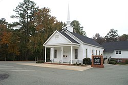
|   The United Methodist Church traces its origin to 1805 [2]   | |
|   Location in Washington County and the state of Georgia   | |
| Coordinates: 33°1′19″N82°58′6″W / 33.02194°N 82.96833°W | |
| Country | United States | 
| State | Georgia | 
| County | Washington | 
| Government | |
| • Type | Mayor-council government | 
| • Mayor | Randall Veal [3] | 
| • City Council | Five members | 
| Area | |
 • Total  | 0.88 sq mi (2.29 km2) | 
| • Land | 0.873 sq mi (2.26 km2) | 
| • Water | 0.07 sq mi (0.18 km2) | 
| Elevation | 312 ft (95 m) | 
| Population  (2020)  | |
 • Total  | 117 | 
| • Density | 143.38/sq mi (55.38/km2) | 
| Time zone | UTC-5 (Eastern (EST)) | 
| • Summer (DST) | UTC-4 (EDT) | 
| ZIP code | 31082  | 
| Area code | 478 | 
| FIPS code | 13-22108 [5] | 
| GNIS feature ID | 0331534 [6] | 
Deepstep is a town in Washington County, Georgia, United States. The population was 117 in 2020.
A post office called Deepstep was established in 1886. [7] The Georgia General Assembly incorporated the place in 1900 as the "Town of Deepstep". [8] The town is named after Deepstep Creek. [9]
Deepstep is located at 33°1′19″N82°58′6″W / 33.02194°N 82.96833°W (33.021827, -82.968337). [10] According to the United States Census Bureau, the town has a total area of 0.88 square miles (2.3 km2), of which 0.873 square miles (2.26 km2) is land and 0.07 square miles (0.18 km2) (2.53%) is water.
| Census | Pop. | Note | %± | 
|---|---|---|---|
| 1910 | 149 | — | |
| 1920 | 184 | 23.5% | |
| 1930 | 180 | −2.2% | |
| 1940 | 174 | −3.3% | |
| 1950 | 159 | −8.6% | |
| 1960 | 139 | −12.6% | |
| 1970 | 107 | −23.0% | |
| 1980 | 120 | 12.1% | |
| 1990 | 111 | −7.5% | |
| 2000 | 132 | 18.9% | |
| 2010 | 131 | −0.8% | |
| 2020 | 117 | −10.7% | |
| U.S. Decennial Census [11] | |||
As of the census [5] of 2000, there were 132 people, 54 households, and 40 families residing in the town. By 2020, its population was 117.