Thomson, Georgia

Last updated

Thomson, Georgia
City
Thomson, Georgia Main Street, May 2017.jpg
Thomson Main Street
McDuffie County Georgia Incorporated and Unincorporated areas Thomson Highlighted.svg
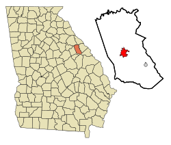
Location in McDuffie County and the state of Georgia
Coordinates: 33°28′2″N82°29′58″W / 33.46722°N 82.49944°W / 33.46722; -82.49944
CountryUnited States
State Georgia
County McDuffie
Area
[1]
  Total4.79 sq mi (12.42 km2)
  Land4.78 sq mi (12.38 km2)
  Water0.01 sq mi (0.04 km2)
Elevation
531 ft (162 m)
Population
 (2020)
  Total6,814
  Density1,425.52/sq mi (550.43/km2)
Time zone UTC−5 (Eastern (EST))
  Summer (DST) UTC−4 (EDT)
ZIP code
30824
Area code 706
FIPS code 13-76280 [2]
GNIS feature ID0356589 [3]
Website www.thomson-mcduffie.gov

Thomson (originally called Slashes) is a city in McDuffie County, Georgia, United States. The population was 6,814 at the 2020 census. The city is the county seat of McDuffie County. [4] Thomson's nickname is "The Camellia City of the South", in honor of the thousands of camellia plants throughout the city. Thomson was founded in 1837 as a depot on the Georgia Railroad. It was renamed in 1853 for railroad official John Edgar Thomson and incorporated February 15, 1854 as a town and in 1870 as a city. It is part of the Augusta – Richmond County Metropolitan Statistical Area.

Contents

History

Thomson, originally called "Slashes", was founded in 1837 as a depot on the Georgia Railroad. It was renamed in 1853 for railroad official John Edgar Thomson. [5] In 1870, Thomson was designated seat of the newly formed McDuffie County. It was incorporated as a town in 1854 and as a city in 1870. [6]

The Old Rock House, built in 1785, is said to be one of Georgia's oldest documented houses with its original design intact. Built by Thomas Ansley, the home is said to be the home of ancestors of former president Jimmy Carter. Thomson is also the birthplace of Populist leader and two-time presidential candidate Thomas E. Watson.

Thomson was home to minor league baseball. An affiliate of the Baltimore Orioles, the Thomson Orioles became members of the 1956 six–team the Class D level Georgia State League. Playing home games at The Brickyard, Thomson led the league in attendance and qualified for the playoffs. The Georgia State League permanently folded following the 1956 season. [7] [8] [9]

Geography

Thomson is located at 33°28′2″N82°29′58″W / 33.46722°N 82.49944°W / 33.46722; -82.49944 (33.467346, −82.499450). [10] According to the United States Census Bureau, the city has a total area of 1.95 square miles (5.1 km2), all land. Thomson is considered part of the Central Savannah River Area geographical designation.

Demographics

Historical population
CensusPop.Note
1880 700
1890 83619.4%
1900 1,15438.0%
1910 2,15186.4%
1920 2,140−0.5%
1930 1,914−10.6%
1940 3,08861.3%
1950 3,48913.0%
1960 4,52229.6%
1970 6,50343.8%
1980 7,0017.7%
1990 6,862−2.0%
2000 6,828−0.5%
2010 6,778−0.7%
2020 6,8140.5%
U.S. Decennial Census [11]
Thomson racial composition as of 2020 [12]
RaceNum.Perc.
White (non-Hispanic)1,90327.93%
Black or African American (non-Hispanic)4,48765.85%
Native American 60.09%
Asian 300.44%
Pacific Islander 30.04%
Other/Mixed 1972.89%
Hispanic or Latino 1882.76%

As of the 2020 United States census, there were 6,814 people, 2,581 households, and 1,610 families residing in the city.

Landmarks

Education

The McDuffie County School District holds pre-school to grade twelve, and consists of four elementary schools, a middle school, a high school and an alternative school. [13] The district has 262 full-time teachers and over 4,312 students. [14]

Notable people

Related Research Articles

<span class="mw-page-title-main">McDuffie County, Georgia</span> County in Georgia, United States

McDuffie County is a county located in the U.S. state of Georgia. As of the 2020 census, the population was 21,632. The county seat is Thomson. The county was created on October 18, 1870 and named after the South Carolina governor and senator George McDuffie.

<span class="mw-page-title-main">Columbia County, Georgia</span> County in Georgia, United States

Columbia County is a county located in the east central portion of the U.S. state of Georgia. As of the 2020 census, the population was 156,010. The legal county seat is Appling, but the de facto seat of county government is Evans.

<span class="mw-page-title-main">Baxley, Georgia</span> City in Georgia, United States

Baxley is a city in Appling County, Georgia, United States. As of the 2020 census, the city had a population of 4,942. The city is the county seat of Appling County.

<span class="mw-page-title-main">Pearson, Georgia</span> City in Georgia, United States

Pearson is a city in Atkinson County, Georgia, United States. The population was 1,821 in 2020. The city is the county seat of Atkinson County.

<span class="mw-page-title-main">Folkston, Georgia</span> City in Georgia, United States

Folkston is a city in and the county seat of Charlton County, Georgia, United States. The population was 4,464 in 2020.

<span class="mw-page-title-main">Harlem, Georgia</span> City in Georgia, United States

Harlem is a city in Columbia County, Georgia, United States. It is part of the Augusta metropolitan area. The population was 2,666 at the 2010 census, up from 1,814 in 2000. This city was named after the neighborhood in the borough of Manhattan. Harlem is the birthplace of comedian Oliver Hardy; the annual Harlem Oliver Hardy Festival is held on the first Saturday each October on Main Street in his honor.

<span class="mw-page-title-main">Swainsboro, Georgia</span> City in Georgia, United States

Swainsboro is a city in Emanuel County, Georgia, United States. As of the 2020 census, the city had a population of 7,425. The city is the county seat of Emanuel County.

<span class="mw-page-title-main">Lilburn, Georgia</span> City in Georgia, United States

Lilburn is a city in Gwinnett County, Georgia, United States. The population was 14,502 at the 2020 census. The estimated population was 12,810 in 2019. It is a part of the Atlanta metropolitan area.

<span class="mw-page-title-main">Loganville, Georgia</span> City in Georgia, United States

Loganville is a city in Walton and Gwinnett counties, Georgia, United States. The population was 10,458 at the 2010 census. Loganville is located about 36 mi (58 km) east of Atlanta and is part of the Atlanta metropolitan area.

<span class="mw-page-title-main">Norcross, Georgia</span> City in Georgia, United States

Norcross is a city located in Gwinnett County, Georgia, United States. According to the 2010 census, the population was 9,116, while in 2020, the population increased to 17,209. Norcross is part of the Atlanta-Sandy Springs-Marietta metropolitan statistical area.

<span class="mw-page-title-main">McDonough, Georgia</span> City in Georgia, United States

McDonough is a city in Henry County, Georgia, United States. It is part of the Atlanta metropolitan area. Its population was 22,084 at the 2010 census, up from 8,493 in 2000. The city is the county seat of Henry County. The unincorporated communities of Blacksville, Flippen, Kelleytown, and Ola are located near McDonough, and addresses in those communities have McDonough ZIP Codes.

<span class="mw-page-title-main">Lincolnton, Georgia</span> City in Georgia, United States

Lincolnton is a city and the county seat of Lincoln County, Georgia, United States. The population was 1,480 at the 2020 census. It contains numerous houses and historic districts listed on the National Register of Historic Places. Both the city and the county were named for General Benjamin Lincoln, who served in the Continental Army during the American Revolution.

<span class="mw-page-title-main">Dearing, Georgia</span> Town in Georgia, United States

Dearing is a town in McDuffie County, Georgia, United States. The population was 529 at the 2020 census. It is part of the Augusta metropolitan area.

<span class="mw-page-title-main">Tifton, Georgia</span> City in Georgia, United States

Tifton is a city in and the county seat of Tift County, Georgia, United States. The population was 17,045 at the 2020 census.

<span class="mw-page-title-main">Lyons, Georgia</span> City in Georgia, United States

Lyons is a city in Toombs County, Georgia, United States. The population was 4,239 in 2020. The city is the county seat of Toombs County.

<span class="mw-page-title-main">Sandersville, Georgia</span> City in Georgia, United States

The city of Sandersville is the county seat of Washington County, Georgia, United States. The population was 5,813 in 2020. It is also a part of the Central Savannah River Area. Sandersville is known as the "Kaolin Capital of the World" due to its abundance of kaolin.

<span class="mw-page-title-main">Jesup, Georgia</span> City in Georgia, United States

Jesup is a city in Wayne County, Georgia, United States. The population was 9,809 at the 2020 census. The city is the county seat of Wayne County.

<span class="mw-page-title-main">Meadville, Mississippi</span> Town in Mississippi, United States

Meadville is a town in and the county seat of Franklin County, Mississippi, United States, in the southwest part of the state. The population was 449 at the 2010 census, down from 519 at the 2000 census. It is situated north of the Homochitto River, which runs from the northeast to the southwest through the county on its way to its outlet at the Mississippi River.

<span class="mw-page-title-main">Sanford, North Carolina</span> City in North Carolina, United States

Sanford is a city in Lee County, North Carolina, United States. The population was 30,261 at the 2020 census. It is the county seat of Lee County. The geographic center of North Carolina is located northwest of the city, in Chatham County.

<span class="mw-page-title-main">Greenwood, South Carolina</span> City in South Carolina, United States

Greenwood is a city in and the county seat of Greenwood County, South Carolina. The population in the 2020 United States Census was 22,545 down from 23,222 at the 2010 census. The city is home to Lander University.

References

  1. "2020 U.S. Gazetteer Files". United States Census Bureau. Retrieved December 18, 2021.
  2. "U.S. Census website". United States Census Bureau . Retrieved January 31, 2008.
  3. "US Board on Geographic Names". United States Geological Survey. October 25, 2007. Retrieved January 31, 2008.
  4. "Find a County". National Association of Counties. Retrieved June 7, 2011.
  5. Krakow, Kenneth K. (1975). Georgia Place-Names: Their History and Origins (PDF). Macon, GA: Winship Press. p. 225. ISBN   0-915430-00-2.
  6. Hellmann, Paul T. (May 13, 2013). Historical Gazetteer of the United States. Routledge. p. 249. ISBN   978-1135948597 . Retrieved November 30, 2013.
  7. "1956 Georgia State League". Baseball-Reference.com.
  8. "The Brickyard". www.visitthomsonga.com.
  9. Johnson, Lloyd; Wolff, Miles, eds. (2007). The Encyclopedia of Minor League Baseball (Third ed.). Baseball America. ISBN   978-1932391176.
  10. "US Gazetteer files: 2010, 2000, and 1990". United States Census Bureau. February 12, 2011. Retrieved April 23, 2011.
  11. "Census of Population and Housing". Census.gov. Retrieved June 4, 2015.
  12. "Explore Census Data". data.census.gov. Retrieved December 15, 2021.
  13. Georgia Board of Education [ permanent dead link ], Retrieved June 23, 2010.
  14. School Stats, Retrieved June 23, 2010.