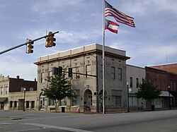
Sylvester, Georgia

Last updated

Sylvester, Georgia
Sylvester City Hall.JPG
Sylvester City Hall
Flag of Sylvester, Georgia.png
Seal of Sylvester, Georgia.png
City of Sylvester, GA Logo.png
Nickname: 
Motto: 
"Small Town. Big Heart." [1]
Worth County Georgia Incorporated and Unincorporated areas Sylvester Highlighted.svg
Location in Worth County and the state of Georgia
Coordinates: 31°31′53″N83°50′10″W / 31.53139°N 83.83611°W / 31.53139; -83.83611
Country United States
State Georgia
County Worth
Settled1893
Incorporated (City)December 21st, 1898
Area
[3]
  Total6.60 sq mi (17.09 km2)
  Land6.56 sq mi (16.99 km2)
  Water0.04 sq mi (0.10 km2)
Elevation
387 ft (118 m)
Population
 (2020)
  Total5,644
  Density860.37/sq mi (332.21/km2)
Time zone UTC-5 (Eastern (EST))
  Summer (DST) UTC-4 (EDT)
ZIP code
31791
Area code 229
FIPS code 13-75188 [4]
GNIS feature ID0356576 [5]
Website cityofsylvester.com

Sylvester is the county seat of Worth County, Georgia, United States. The population was 5,644 in 2020. The city is the county seat [6] and business center of Worth County [7] and is claimed to be the Peanut Capital of the World due to its peanut production. [1]

Contents

History

Sylvester was platted in 1893. [8] The Georgia General Assembly incorporated Sylvester as a town in 1898. [9]

Geography

Sylvester is located at 31°31′53″N83°50′10″W / 31.53139°N 83.83611°W / 31.53139; -83.83611 (31.531425, -83.836233). [10] According to the United States Census Bureau, the city has a total area of 5.7 square miles (15 km2), of which 5.7 square miles (15 km2) is land and 0.04 square miles (0.10 km2) (0.52%) is water.

Sylvester is located on US 82.svg U.S. Highway 82 at the junction of Georgia 33.svg Georgia State Route 33. Georgia 256.svg Georgia State Route 256 enters into southeast Sylvester, where it is co-designated Martin Luther King Jr. Drive.

Demographics

Historical population
CensusPop.Note
1900 552
1910 1,447162.1%
1920 1,5476.9%
1930 1,98428.2%
1940 2,19110.4%
1950 2,62319.7%
1960 3,61037.6%
1970 4,22617.1%
1980 5,86038.7%
1990 5,702−2.7%
2000 5,9905.1%
2010 6,1883.3%
2020 5,644−8.8%
U.S. Decennial Census [11]
Sylvester racial composition as of 2020 [12]
RaceNum.Perc.
White (non-Hispanic)2,02335.84%
Black or African American (non-Hispanic)3,34259.21%
Native American 60.11%
Asian 470.83%
Pacific Islander 60.11%
Other/Mixed 1292.29%
Hispanic or Latino 911.61%

As of the 2020 United States census, there were 5,644 people, 2,346 households, and 1,709 families residing in the city.

Education

The Worth County School District holds pre-school to grade twelve, and consists of two elementary schools, a middle school, and a high school. [13] The district has 296 full-time teachers and over 4,354 students. [14]

Notable people

Related Research Articles

<span class="mw-page-title-main">Worth County, Georgia</span> County in Georgia, United States

Worth County is a county located in the south-central portion of the U.S. state of Georgia. As of the 2020 census, the population was 20,784. The county seat is Sylvester. Worth County is included in the Albany, GA metropolitan statistical area.

<span class="mw-page-title-main">Dooly County, Georgia</span> County in Georgia, United States

Dooly County is a county located in the central portion of the U.S. state of Georgia. As of the 2020 census, the population was 11,208. The county seat is Vienna. The county was created by an act of the Georgia General Assembly on May 15, 1821, and named for Colonel John Dooly, a Georgia American Revolutionary War fighter. It was one of the original landlot counties created from land ceded from the Creek Nation.

<span class="mw-page-title-main">Colquitt County, Georgia</span> County in Georgia, United States

Colquitt County is a county in the U.S. state of Georgia. As of the 2020 census, the population was 45,898. The county seat is Moultrie. The county was created on February 25, 1856, and is named for Walter Terry Colquitt, a U.S. senator. Colquitt County comprises the Moultrie, GA micropolitan statistical area.

<span class="mw-page-title-main">Bleckley County, Georgia</span> County in Georgia, United States

Bleckley County is a county located in the central portion of the U.S. state of Georgia. As of the 2020 census, the population was 12,583. The county seat is Cochran.

<span class="mw-page-title-main">Folkston, Georgia</span> City in Georgia, United States

Folkston is a city in and the county seat of Charlton County, Georgia, United States. The population was 4,464 in 2020.

<span class="mw-page-title-main">Norman Park, Georgia</span> City in Georgia, United States

Norman Park is a city in Colquitt County, Georgia, United States. The population was 963 in 2020.

<span class="mw-page-title-main">Adel, Georgia</span> City in Georgia, United States

Adel is a city in and the county seat of Cook County, Georgia, United States, located fifty-two miles (84 km) southeast of Albany. As of the 2020 census, the city had a population of 5,571.

<span class="mw-page-title-main">Greensboro, Georgia</span> City in Georgia, United States

Greensboro is a city in and the county seat of Greene County, Georgia, United States. Its population was 3,648 as of the 2020 census. The city is located approximately halfway between Atlanta and Augusta on Interstate 20.

<span class="mw-page-title-main">Norcross, Georgia</span> City in Georgia, United States

Norcross is a city located in Gwinnett County, Georgia, United States. According to the 2010 census, the population was 9,116, while in 2020, the population increased to 17,209. Norcross is part of the Atlanta-Sandy Springs-Marietta metropolitan statistical area.

<span class="mw-page-title-main">Monticello, Georgia</span> City in Georgia, United States

Monticello is the largest city in and the county seat of Jasper County, Georgia, United States. The city includes historic buildings such as the Jasper County Courthouse, Monticello High School and the Monticello Historic District. The population was 2,657 at the 2010 census. It is 56 miles (90 km) southeast of Atlanta.

<span class="mw-page-title-main">Gray, Georgia</span> City in Georgia, United States

Gray is a city in Jones County, Georgia, United States. The population was 3,276 at the 2010 census, up from 1,811 at the 2000 census. In 2020, its population was 3,436. The city is the county seat of Jones County. It is part of the Macon metropolitan area.

<span class="mw-page-title-main">Colquitt, Georgia</span> City in Georgia, United States

Colquitt is a city and the county seat of Miller County, in the southwestern portion of the U.S. state of Georgia. The population was 2,001 at the 2020 census. Colquitt has been the county seat of Miller County since Miller County was incorporated by the Georgia Legislature in 1856. The city formally incorporated on December 19, 1860, and is Miller County's only incorporated municipality. Colquitt is named for U.S. Congressman and Senator Walter Terry Colquitt.

<span class="mw-page-title-main">Camilla, Georgia</span> City in Georgia, United States

Camilla is a city in Mitchell County, Georgia, United States, and is its county seat. As of the 2020 census, the city had a population of 5,187, down from 5,360 in 2010.

<span class="mw-page-title-main">Blackshear, Georgia</span> City in Georgia, United States

The city of Blackshear is the county seat of Pierce County, Georgia, United States. As of the 2020 census, the city had a population of 3,506.

<span class="mw-page-title-main">Lyons, Georgia</span> City in Georgia, United States

Lyons is a city in Toombs County, Georgia, United States. The population was 4,239 in 2020. The city is the county seat of Toombs County.

<span class="mw-page-title-main">Ashburn, Georgia</span> City in Georgia, United States

The city of Ashburn is the county seat of Turner County, Georgia, United States. As of 2020, its population was 4,291. Ashburn's government is classified as a council/manager form of municipal government.

<span class="mw-page-title-main">Monroe, Georgia</span> City in Georgia, United States

Monroe is a city in Walton County, Georgia, United States, serving as the county seat. It is located both one hour east of Atlanta via US 78 and GA 138 to I-20 and east of Hartsfield–Jackson International Airport and is one of the exurban cities in the Atlanta metropolitan area. The population was 14,928 at the 2020 U.S. census.

<span class="mw-page-title-main">Jesup, Georgia</span> City in Georgia, United States

Jesup is a city in Wayne County, Georgia, United States. The population was 9,809 at the 2020 census. The city is the county seat of Wayne County.

<span class="mw-page-title-main">Rochelle, Georgia</span> City in Georgia, United States

Rochelle is a city in Wilcox County, Georgia, United States. Per the 2020 census, the population was 1,167.

<span class="mw-page-title-main">Irwinton, Georgia</span> City in Georgia, United States

Irwinton is a city in Wilkinson County, Georgia, United States. The population was 531 in 2020. The city is the county seat of Wilkinson County.

References

  1. 1 2 3 "City of Sylvester Georgia". City of Sylvester Georgia. Retrieved September 4, 2012.
  2. "Sylvester". GeorgiaGov. Retrieved September 4, 2012.
  3. "2020 U.S. Gazetteer Files". United States Census Bureau. Retrieved December 18, 2021.
  4. "U.S. Census website". United States Census Bureau . Retrieved January 31, 2008.
  5. "US Board on Geographic Names". United States Geological Survey. October 25, 2007. Retrieved January 31, 2008.
  6. "Profile for Sylvester, Georgia, GA". ePodunk. Retrieved September 4, 2012.
  7. "Find a County". National Association of Counties. Retrieved June 7, 2011.
  8. Krakow, Kenneth K. (1975). Georgia Place-Names: Their History and Origins (PDF). Macon, GA: Winship Press. p. 218. ISBN   0-915430-00-2.
  9. Acts Passed by the General Assembly of Georgia. J. Johnston. 1899. p. 269.
  10. "US Gazetteer files: 2010, 2000, and 1990". United States Census Bureau. February 12, 2011. Retrieved April 23, 2011.
  11. "Census of Population and Housing". Census.gov. Retrieved June 4, 2015.
  12. "Explore Census Data". data.census.gov. Retrieved December 18, 2021.
  13. Georgia Board of Education, Retrieved June 30, 2010.
  14. School Stats, Retrieved June 30, 2010.