Colquitt, Georgia

Last updated

Colquitt, Georgia
Colquitt City Hall Municipal Complex.jpg
Colquitt City Hall
Colquitt Seal.png
Miller County Georgia Incorporated and Unincorporated areas Colquitt Highlighted.svg
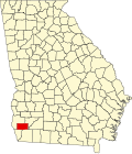
Location in Miller County and the state of Georgia
Coordinates: 31°10′23″N84°43′43″W / 31.17306°N 84.72861°W / 31.17306; -84.72861
Country Flag of the United States.svg  United States
State Flag of Georgia (U.S. state).svg  Georgia
County   Miller
Incorporated (City)December 19, 1860 [1]
Area
[2]
  Total8.27 sq mi (21.42 km2)
  Land8.23 sq mi (21.32 km2)
  Water0.04 sq mi (0.10 km2)
Elevation
167 ft (51 m)
Population
 (2020) [3]
  Total2,001
  Density243.08/sq mi (93.85/km2)
Time zone UTC-5 (Eastern (EST))
  Summer (DST) UTC-4 (EDT)
ZIP code
39837
Area code 229
FIPS code 13-18000 [4]
GNIS feature ID0355248 [5]
Website www.colquittga.gov

Colquitt is a city and the county seat of Miller County, in the southwestern portion of the U.S. state of Georgia. The population was 2,001 at the 2020 census. [3] [6] Colquitt has been the county seat of Miller County since Miller County was incorporated by the Georgia Legislature in 1856. The city formally incorporated on December 19, 1860, [1] and is Miller County's only incorporated municipality. Colquitt is named for U.S. Congressman and Senator Walter Terry Colquitt. [7]

Contents

The Colquitt Town Square Historic District was added to the National Register of Historic Places in 1983.

Geography

Colquitt is located in the center of Miller County at 31°10′23″N84°43′43″W / 31.17306°N 84.72861°W / 31.17306; -84.72861 (31.173090, -84.728512). [8]

The city is located along U.S. Route 27, Georgia State Route 45, and Georgia State Route 91 in southwestern Georgia. U.S. 27 runs northwest-southeast through the center of town as Crawford Street, leading northwest 21 mi (34 km) to Blakely and southeast 22 mi (35 km) to Bainbridge. GA-45 runs north-south through the city concurrent with U.S. 27 and GA-91, and leads north 9 mi (14 km) to Damascus and southwest 14 mi (23 km) to Iron City. GA-91 also runs north-south through the city as well, and leads northeast 28 mi (45 km) to Newton and southwest 14 mi (23 km) to Donalsonville.

According to the United States Census Bureau, the city has a total area of 8.3 square miles (21 km2), of which 0.04 square miles (0.10 km2), or 0.48%, are water. [2]

Demographics

Historical population
CensusPop.Note
1880 119
1900 320
1910 60087.5%
1920 81035.0%
1930 8322.7%
1940 1,41670.2%
1950 1,66417.5%
1960 1,556−6.5%
1970 2,02630.2%
1980 2,0651.9%
1990 1,991−3.6%
2000 1,939−2.6%
2010 1,9922.7%
2020 2,0010.5%
U.S. Decennial Census [9]
Colquitt racial composition as of 2020 [10]
RaceNum.Perc.
White (non-Hispanic)80240.08%
Black or African American (non-Hispanic)1,09654.77%
Native American 30.15%
Asian 180.9%
Other/Mixed 512.55%
Hispanic or Latino 311.55%

As of the 2020 United States census, there were 2,001 people, 854 households, and 520 families residing in the city.

Education

The middle/high school entrance of the Miller County School District school building Miller County Middle High School.jpg
The middle/high school entrance of the Miller County School District school building

Colquitt is part of the Miller County School District. [11] [12] It is served by:

Public Library

James W. Merritt, Jr. Memorial Library James W. Merritt Memorial Library, Colquitt.jpg
James W. Merritt, Jr. Memorial Library

Colquitt is home to the Miller County - James W. Merritt, Jr. Memorial Library. [13] The library serves the citizens of Miller County with a collection of print and audiovisual materials. The library is located at 259 E. Main Street in Colquitt.

Notable people

Related Research Articles

<span class="mw-page-title-main">Thomas County, Georgia</span> County in Georgia, United States

Thomas County is a county located in the U.S. state of Georgia. As of the 2020 census the population was 45,798. The county seat is Thomasville. Thomas County comprises the Thomasville, GA micropolitan statistical area.

<span class="mw-page-title-main">Mitchell County, Georgia</span> County in Georgia, United States

Mitchell County is a county in the U.S. state of Georgia. As of the 2020 census, the population was 21,755. The county seat is Camilla. Mitchell County was created on December 21, 1857.

<span class="mw-page-title-main">Miller County, Georgia</span> County in Georgia, United States

Miller County is a county located in the southwestern part of the U.S. state of Georgia. As of the 2020 census, the population was 6,000. The county seat is Colquitt. The county was created on February 26, 1856, and named after Andrew Jackson Miller (1806–56), president of the Medical College of Georgia.

<span class="mw-page-title-main">Colquitt County, Georgia</span> County in Georgia, United States

Colquitt County is a county in the U.S. state of Georgia. As of the 2020 census, the population was 45,898. The county seat is Moultrie. The county was created on February 25, 1856, and is named for Walter Terry Colquitt, a U.S. senator. Colquitt County comprises the Moultrie, GA micropolitan statistical area.

<span class="mw-page-title-main">Doerun, Georgia</span> City in Georgia, United States

Doerun is a city in Colquitt County, Georgia, United States. The population was 738 in 2020.

<span class="mw-page-title-main">Moultrie, Georgia</span> City in Georgia, United States

Moultrie is the county seat and largest city of Colquitt County, Georgia, United States. It is the third largest city in Southwest Georgia, behind Thomasville and Albany. As of the 2020 census, Moultrie's population was 14,638. It was originally known as Ochlockoney until it was incorporated by the Georgia General Assembly in 1859. Moultrie is an agricultural community set in the Southern Rivers part of Georgia.

<span class="mw-page-title-main">Norman Park, Georgia</span> City in Georgia, United States

Norman Park is a city in Colquitt County, Georgia, United States. The population was 963 in 2020.

<span class="mw-page-title-main">Trenton, Georgia</span> City in Georgia, United States

Trenton is a city and the only incorporated municipality in Dade County, Georgia, United States—and as such, it serves as the county seat. The population was 2,195 at the 2020 census. Trenton is part of the Chattanooga, Tennessee–GA Metropolitan Statistical Area.

<span class="mw-page-title-main">Damascus, Georgia</span> City in Georgia, United States

Damascus is a city in Early County, Georgia, United States. The population was 212 in the 2020 census, down from 254 in the 2010 census.

<span class="mw-page-title-main">Blue Ridge, Georgia</span> City in Georgia, United States

Blue Ridge is a city in Fannin County, Georgia, United States. As of the 2020 census, the city had a population of 1,253. The city is the county seat of Fannin County and the largest city in the county as well.

<span class="mw-page-title-main">Hartwell, Georgia</span> City in Georgia, United States

Hartwell is a city in Hart County, Georgia, United States. The population was 4,469 at the 2010 census. The city is the county seat of Hart County.

<span class="mw-page-title-main">Smithville, Georgia</span> City in Georgia, United States

Smithville is a city in Lee County, Georgia, United States. The population was 593 in 2020. It is part of the Albany, Georgia metropolitan statistical area.

<span class="mw-page-title-main">Camilla, Georgia</span> City in Georgia, United States

Camilla is a city in Mitchell County, Georgia, United States, and is its county seat. As of the 2020 census, the city had a population of 5,187, down from 5,360 in 2010.

<span class="mw-page-title-main">Sale City, Georgia</span> Town in Georgia, United States

Sale City is a town in Mitchell County, Georgia, United States. The population was 354 at the 2020 census.

<span class="mw-page-title-main">Donalsonville, Georgia</span> City in Georgia, United States

Donalsonville is a city in and the county seat of Seminole County, Georgia, United States. The population was 2,833 in 2020.

<span class="mw-page-title-main">Butler, Georgia</span> City in Georgia, United States

Butler is the county seat of Taylor County, Georgia, United States. Its population was 1,972 at the 2010 census.

<span class="mw-page-title-main">Dawson, Georgia</span> City in the United States

Dawson is a city in and the county seat of Terrell County, Georgia, United States. The population was 4,414 at the 2020 census. Incorporated on December 22, 1857, the city is named for Senator William Crosby Dawson. Dawson is part of the Albany, Georgia metropolitan statistical area.

<span class="mw-page-title-main">Thomaston, Georgia</span> City in Georgia, United States

Thomaston is a city in and the county seat of Upson County, Georgia, United States. The population was 9,170 at the 2010 census. It is the principal city of and is included in the Thomaston, Georgia Micropolitan Statistical Area, which is included in the Atlanta - Sandy Springs (GA) - Gainesville (GA) - Alabama (partial) Combined Statistical Area.

<span class="mw-page-title-main">Monroe, Georgia</span> City in Georgia, United States

Monroe is a city in Walton County, Georgia, United States, serving as the county seat. It is located both one hour east of Atlanta via US 78 and GA 138 to I-20 and east of Hartsfield–Jackson International Airport and is one of the exurban cities in the Atlanta metropolitan area. The population was 14,928 at the 2020 U.S. census.

<span class="mw-page-title-main">Preston, Georgia</span> Unincorporated community in Georgia, United States

Preston is an unincorporated community in Webster County, Georgia, United States, located seventeen miles west of Americus. The population was 453 at the 2000 census. From 1857 to 2009, Preston was an incorporated municipality. The community is the county seat of Webster County.

References

  1. 1 2 "City of Colquitt". Georgia.gov. Retrieved April 28, 2010.
  2. 1 2 "2022 U.S. Gazetteer Files: Georgia". United States Census Bureau. Retrieved January 26, 2023.
  3. 1 2 "P1. Race – Colquitt city, Georgia: 2020 DEC Redistricting Data (PL 94-171)". U.S. Census Bureau. Retrieved January 26, 2023.
  4. "U.S. Census website". United States Census Bureau . Retrieved January 31, 2008.
  5. "US Board on Geographic Names". United States Geological Survey. October 25, 2007. Retrieved January 31, 2008.
  6. "Find a County". National Association of Counties. Archived from the original on May 31, 2011. Retrieved June 7, 2011.
  7. "Cities & Counties: Colquitt". Archived October 16, 2012, at the Wayback Machine The New Georgia Encyclopedia. Retrieved April 28, 2010.
  8. "US Gazetteer files: 2010, 2000, and 1990". United States Census Bureau. February 12, 2011. Retrieved April 23, 2011.
  9. "Census of Population and Housing". Census.gov. Retrieved June 4, 2015.
  10. "Explore Census Data". data.census.gov. Retrieved December 18, 2021.
  11. Georgia Board of Education [ permanent dead link ], Retrieved June 24, 2010.
  12. School Stats, Retrieved June 24, 2010.
  13. "Homepage". Southwest Georgia Regional Library System. Retrieved July 21, 2017.
  14. "Role of the Lt. Governor". Archived 2010-03-12 at the Wayback Machine Georgia.gov. Retrieved April 28, 2010.
  15. "Rites at Colquitt for Mrs. Z. Toole". The Atlanta Constitution. November 2, 1947. p. 12A. Retrieved June 30, 2020 via newspapers.com.