Perry, Georgia

Last updated

Perry, Georgia
Perry City Hall, Georgia.JPG
Perry City Hall
Motto: 
"Where Georgia comes together" [1]
Houston County Georgia Incorporated and Unincorporated areas Perry Highlighted.svg
Location in Houston County and the state of Georgia
Coordinates: 32°27′54″N83°43′16″W / 32.46500°N 83.72111°W / 32.46500; -83.72111 Coordinates: 32°27′54″N83°43′16″W / 32.46500°N 83.72111°W / 32.46500; -83.72111
Country United States
State Georgia
Counties Houston, Peach
Named for Oliver Hazard Perry
Government
   Mayor Randall Walker
   City Manager R. Lee Gilmour
Area
[2]
  Total27.11 sq mi (70.20 km2)
  Land26.98 sq mi (69.87 km2)
  Water0.13 sq mi (0.34 km2)
Elevation
364 ft (111 m)
Population
 (2020)
  Total20,624
  Density764.53/sq mi (295.19/km2)
Time zone UTC-5 (EST)
  Summer (DST) UTC-4 (EDT)
ZIP code
31069
Area code 478
FIPS code 13-60340 [3]
GNIS feature ID0320389 [4]
Website www.perry-ga.gov , www.perryga.com

Perry is a city in Houston and Peach counties in the U.S. state of Georgia. It is the county seat [5] of Houston County. The population was 13,839 at the 2010 census, [6] up from 9,602 at the 2000 census. As of 2019 the estimated population was 17,894. [7] It is part of the Warner Robins, Georgia Metropolitan Statistical Area, within the Macon–Bibb County–Warner Robins Combined Statistical Area.

Contents

Perry is best known as the location of the annual Georgia National Fair. [8]

History

Founded in 1823 as "Wattsville", the town was located near the center of Houston County and served as its courthouse. The name was soon changed to honor Commodore Oliver Hazard Perry, a hero of the War of 1812. [9] The Georgia General Assembly incorporated the town on December 9, 1824. The original city limit was a circle, one mile in diameter, except where bounded on the north by Big Indian Creek.

Antebellum industry in Perry included gristmills, sawmills, and cotton gins. The Houston Home Journal began publishing in 1870. Cotton was the most significant commodity crop in the 20th century.

Tourism has been important to the local economy since about 1920, when U.S. Highway 41 to Florida was paved. The New Perry Hotel, built in 1870 and rebuilt in 1925, became a landmark for many Florida tourists. The downtown area has emphasized its historic heritage and has several quaint shops and restaurants.

Since World War II, when Robins Air Force Base was established in nearby Warner Robins, the military has been a significant employer in the area. Warner Robins is several times larger than Perry. Other manufacturers in the city have included Frito-Lay, Perdue Farms (formally Heileman Brewing Co.), and Cemex, Inc. (formally Penn-Dixie Cement and Medusa Cement Company).

In the early 1960s Interstate 75 was constructed through the western side of the city. It has attracted more businesses that cater to travelers. The Georgia National Fairgrounds and Agricenter opened in 1990. The Go Fish Georgia Education Center opened October 8, 2010. [10]

Geography

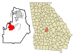
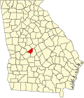
Perry is located in west-central Houston County at 32°27′54″N83°43′16″W / 32.46500°N 83.72111°W / 32.46500; -83.72111 (32.464940, −83.721163). [11] The city limits extend northwest into Peach County. It is on Big Indian Creek, a tributary of the Ocmulgee River.

U.S. Highway 41 passes through the center of Perry, leading north 30 miles (48 km) to Macon and south 16 miles (26 km) to Unadilla. Interstate 75, the major north-south artery through Georgia, passes through the western side of Perry, with access from Exits 134 through 138. I-75 leads north 106 miles (171 km) to Atlanta and south 123 miles (198 km) to Valdosta. U.S. Highway 341 also passes through Perry, leading northwest 12 miles (19 km) to Fort Valley and southeast 21 miles (34 km) to Hawkinsville.

According to the United States Census Bureau, Perry has a total area of 26.3 square miles (68.1 km2), of which 26.2 square miles (67.8 km2) are land and 0.1 square miles (0.3 km2), or 0.48%, are water. [6]

Airport

The Perry-Houston County Airport serves Middle Georgia's general aviation needs with a 5,000' x 100' runway, hangar space, a repair/maintenance facility, flight school, and both aviation and jet fuel services. Presently the facility is the base for 89 aircraft, with 66 public and corporate hangars.

Culture

Georgia National Fair

The Georgia National Fair is a state-sponsored fair that is held every October at the Georgia National Fairgrounds and Agricenter in the southern part of Perry. The fair is an 11-day event offering a wide range of activities and shows, such as agricultural, livestock and horse shows, home and fine arts competitions, youth organization events (4-H, FBLA, FCCLA, FFA, and TSA), circus, midway rides, and games, fair food, major live music concerts in Reaves Arena, family entertainment, and nightly fireworks.

Go Fish Education Center

The Go Fish Education Center takes visitors on an educational journey through Georgia's watersheds to learn about the diverse aquatic wildlife, their natural habitats and the impact of water pollution. Visitors can see freshwater aquariums, explore underwater habitats, view aquatic wildlife, catch fish in a stocked pond, view a movie exploring Georgia's fishing options and traditions, and try out interactive fishing and boating simulators. The Go Fish Education Center is part of the Georgia Department of Natural Resources, Wildlife Resources Division (Fisheries Management Section). The hours are Friday & Saturday from 9:00 am to 5:00 pm and Sunday from 1:00 pm to 5:00 pm. The center is reserved Tuesday through Thursday for school field trips and other groups.

Perry Buzzard Drop

The Buzzard drops in Perry each New Year's Eve with live entertainment, spirits sold on-site, a dance contest, and souvenir memorabilia.

Perry Area Historical Museum

The Perry Area Historical Museum was founded to identify, protect and preserve the area's historical landmarks, artifacts, and histories of its people. Exhibits include military, social, agricultural, fashion, education, and political memorabilia. Services offered by the museum include a heritage library of local and regional publications, records, documents, family histories, and other research material. Programs offered include guided tours, special events, kids programs, and activities. The hours are Tuesday through Thursday, from 10:00 am to 12:00 noon and 2:00 pm to 4:00 pm. The museum is also open by appointment.

Perry Dogwood Festival

The Dogwood Festival is held the second weekend of April each year in downtown Perry. For each festival, there is a pageant, 5k, arts & crafts sale, food vendors, kids zone, youth entertainment stage, dog dock-diving competitions, and a hot air balloon rally.

Other attractions

Demographics

Historical population
CensusPop.Note
1870 836
1880 92911.1%
1890 665−28.4%
1900 650−2.3%
1910 649−0.2%
1920 6784.5%
1930 1,398106.2%
1940 1,54210.3%
1950 3,849149.6%
1960 6,03256.7%
1970 7,77128.8%
1980 9,45321.6%
1990 9,4520.0%
2000 9,6021.6%
2010 13,83944.1%
2020 20,62449.0%
U.S. Decennial Census [12]

2020 census

Perry racial composition [13]
RaceNum.Perc.
White (non-Hispanic)11,15254.07%
Black or African American (non-Hispanic)7,13934.62%
Native American 240.12%
Asian 4011.94%
Pacific Islander 150.07%
Other/Mixed 9064.39%
Hispanic or Latino 9874.79%

As of the 2020 United States census, there were 20,624 people, 6,242 households, and 4,160 families residing in the city.

2000 census

As of the census [3] of 2000, there were 9,602 people, 3,720 households, and 2,574 families residing in the city. The population density was 584.7 inhabitants per square mile (225.8/km2). There were 4,053 housing units at an average density of 246.8 per square mile (95.3/km2). The racial makeup of the city was 59.53% White, 37.18% African American, 0.21% Native American, 1.25% Asian, 0.04% Pacific Islander, 0.90% from other races, and 0.90% from two or more races. Hispanic or Latino of any race were 1.85% of the population.

There were 3,720 households, out of which 32.8% had children under the age of 18 living with them, 45.2% were married couples living together, 19.7% had a female householder with no husband present, and 30.8% were non-families. 26.8% of all households were made up of individuals, and 10.3% had someone living alone who was 65 years of age or older. The average household size was 2.50 and the average family size was 3.03.

In the city, the population was spread out, with 25.9% under the age of 18, 9.8% from 18 to 24, 30.1% from 25 to 44, 20.2% from 45 to 64, and 14.0% who were 65 years of age or older. The median age was 35 years. For every 100 females, there were 89.9 males. For every 100 females age 18 and over, there were 84.6 males.

The median income for a household in the city was $31,418, and the median income for a family was $38,480. Males had a median income of $35,870 versus $21,136 for females. The per capita income for the city was $18,266. About 15.6% of families and 18.8% of the population were below the poverty line, including 24.4% of those under age 18 and 15.4% of those aged 65 or over.

Notable people

Related Research Articles

<span class="mw-page-title-main">Houston County, Alabama</span> County in Alabama, United States

Houston County is a county located in the southeastern corner of the U.S. state of Alabama. As of the 2020 census the population was 107,202. Its county seat is Dothan, which is located on the border and partially in adjacent Henry County.

<span class="mw-page-title-main">Twiggs County, Georgia</span> County in Georgia, United States

Twiggs County is a county located in the central portion of the U.S. state of Georgia. As of the 2020 census, the population was 8,022. The county seat is Jeffersonville. The county was created on December 14, 1809, and named for American Revolutionary War general John Twiggs.

<span class="mw-page-title-main">Seminole County, Georgia</span> County in Georgia, United States

Seminole County is a county located in the southwestern corner of U.S. state of Georgia. As of the 2020 census, the population was 9,147. The county seat is Donalsonville.

<span class="mw-page-title-main">Peach County, Georgia</span> County in Georgia, United States

Peach County is a county located in the central portion of the U.S. state of Georgia. As of the 2020 census, the population was 27,981. Its county seat is Fort Valley. Founded in 1924, it is the state's newest county, taken from Houston and Macon counties on July 18 of that year. Its namesake is the peach on account of it being located in a peach-growing district.

<span class="mw-page-title-main">Houston County, Georgia</span> County in Georgia, United States

Houston County is a county located in the central portion of the U.S. state of Georgia. The population was 163,633 at the 2020 census. Its county seat is Perry; the city of Warner Robins is substantially larger in both area and population.

<span class="mw-page-title-main">Perry County, Arkansas</span> County in Arkansas, United States

Perry County is a county located in the U.S. state of Arkansas. Its population was 10,019 at the 2020 United States Census. The county seat is Perryville. The county was formed on December 18, 1840, and named for Commodore Oliver Hazard Perry, naval hero in the War of 1812. It is an alcohol prohibition or dry county.

<span class="mw-page-title-main">Alma, Georgia</span> City in Georgia, United States

Alma is a city in Bacon County, Georgia, United States, and the county seat. As of the 2020 census, the city had a population of 3,433.

<span class="mw-page-title-main">Nashville, Georgia</span> City in Georgia, United States

Nashville is a city in and the county seat of Berrien County, Georgia, United States. The population was 7,029 at the 2022 census. It is called the "City of Dogwoods", as the tree grows in large numbers around the area.

<span class="mw-page-title-main">Bainbridge, Georgia</span> City in Georgia, United States

Bainbridge is a city in Decatur County, Georgia, United States. The city is the county seat of Decatur County. As of the 2020 census, the city had a population of 14,468.

<span class="mw-page-title-main">Unadilla, Georgia</span> City in Georgia, United States

Unadilla is a city in Dooly County, Georgia, United States. The population was 3,796 at the 2010 census, up from 2,772 in 2000. Dooly State Prison is located in the northeast corner of the city.

<span class="mw-page-title-main">Vienna, Georgia</span> City in Georgia, United States

The city of Vienna is the county seat of Dooly County, Georgia, United States. The population was 4,011 at the 2010 census, up from 2,973 in 2000. Vienna is situated on the Flint River. It was established as Berrien in 1826. In 1833, its name was changed to Drayton. In 1841, it was renamed Vienna. Vienna was disincorporated at the time they changed the city's name to Vienna. The present name is after Vienna, in Austria.

<span class="mw-page-title-main">Centerville, Georgia</span> City in Georgia, United States

Centerville is a city in Houston County, Georgia, United States. The city is a part of the larger Macon-Warner Robins Combined Statistical Area. It was incorporated March 25, 1958. As of the 2010 census, the city had a population of 7,148, up from 4,278 in 2000. The city's central location, proximity to major highways and interstates, and excellent quality of life makes it one of the top bedroom communities in Georgia. In 2016, Centerville was ranked 7th Happiest City in Georgia by zippia.com, a website devoted to career-related rankings.

<span class="mw-page-title-main">Warner Robins, Georgia</span> City in Georgia, United States

Warner Robins is a city in the U.S. state of Georgia, located in Houston and Peach counties in the central part of the state. It is currently Georgia's eleventh-largest incorporated city, with a population of 80,308 in the 2020 Census.

<span class="mw-page-title-main">Marshallville, Georgia</span> City in Georgia, United States

Marshallville is a city in Macon County, Georgia, United States. The population was 1,048 at the 2020 census, down from 1,448 in 2010.

<span class="mw-page-title-main">Byron, Georgia</span> City in Georgia, United States

Byron is a city located primarily in Peach County, Georgia, United States. A small portion of the city also extends into parts of Houston and Crawford counties. The population was estimated to be 5,149 in 2019 by the Census Bureau, an increasing of 14.1% from 4,512 at the 2010 census. The city is in the Warner Robins Metropolitan Statistical Area.

<span class="mw-page-title-main">Fort Valley, Georgia</span> City in Georgia, United States

Fort Valley is a city in and the county seat of Peach County, Georgia, United States. As of the 2020 census, the city had a population of 8,780.

<span class="mw-page-title-main">Hawkinsville, Georgia</span> City in Georgia, United States

Hawkinsville is a city in and the county seat of Pulaski County, Georgia, United States. The population was 4,589 at the 2010 census.

<span class="mw-page-title-main">Lyons, Georgia</span> City in Georgia, United States

Lyons is a city in Toombs County, Georgia, United States. The population was 4,367 at the 2010 census, up from 4,169 in 2000. The city is the county seat of Toombs County.

<span class="mw-page-title-main">Hitchcock, Texas</span> City in Texas, United States

Hitchcock is a city in Galveston County, Texas, United States. The population was 6,961 at the 2010 census.

<span class="mw-page-title-main">Robins Air Force Base</span> US Air Force base at Warner Robins, Georgia, United States

Robins Air Force Base is a major United States Air Force installation located in Houston County, Georgia, United States. The base is located just east of the city of Warner Robins, 18 mi (29 km) south-southeast of Macon and approximately 100 mi (160 km) south-southeast of Atlanta, Georgia. The base is named in honor of Brig Gen Augustine Warner Robins, the Air Force's "father of logistics". The base is the single largest industrial complex in Georgia, employing a workforce of over 25,584 civilian, contractor, and military members.

References

  1. "Perry". City of Perry, Georgia. Archived from the original on May 10, 2017. Retrieved May 19, 2017.
  2. "2020 U.S. Gazetteer Files". United States Census Bureau. Retrieved December 18, 2021.
  3. 1 2 "U.S. Census website". United States Census Bureau . Retrieved January 31, 2008.
  4. "US Board on Geographic Names". United States Geological Survey. October 25, 2007. Archived from the original on February 4, 2012. Retrieved January 31, 2008.
  5. "Find a County". National Association of Counties. Archived from the original on May 31, 2011. Retrieved June 7, 2011.
  6. 1 2 "Geographic Identifiers: 2010 Demographic Profile Data (G001): Perry city, Georgia". American Factfinder. U.S. Census Bureau. Retrieved May 19, 2017.[ dead link ]
  7. "Population and Housing Unit Estimates" . Retrieved May 21, 2020.
  8. Becker, Jim. "Seniors Visit Georgie". Senior Citizen Travel. Mandarich Media Group. Retrieved February 24, 2019.
  9. Krakow, Kenneth K. (1975). Georgia Place-Names: Their History and Origins (PDF). Macon, GA: Winship Press. p. 174. ISBN   0-915430-00-2.
  10. "Press Release | Georgia DNR - Wildlife Resources Division". Archived from the original on October 26, 2011. Retrieved February 26, 2012.
  11. "US Gazetteer files: 2010, 2000, and 1990". United States Census Bureau. February 12, 2011. Retrieved April 23, 2011.
  12. "Census of Population and Housing". Census.gov. Retrieved June 4, 2015.
  13. "Explore Census Data". data.census.gov. Retrieved December 18, 2021.
  14. Barone, Michael; Ujifusa, Grant (1987). The Almanac of American Politics 1988 . National Journal . p. 295.