City of Thomaston | |
---|---|
Motto: "One of the Best 100 Towns" [1] | |
Coordinates: 32°54′N84°20′W / 32.900°N 84.333°W | |
Country | United States |
State | Georgia |
County | Upson |
Area | |
• Total | 9.74 sq mi (25.24 km2) |
• Land | 9.54 sq mi (24.71 km2) |
• Water | 0.20 sq mi (0.53 km2) |
Elevation | 784 ft (239 m) |
Population (2020) | |
• Total | 9,816 |
• Density | 1,029.04/sq mi (397.32/km2) |
Time zone | UTC-5 (Eastern (EST)) |
• Summer (DST) | UTC-4 (EDT) |
ZIP code | 30286 |
Area code | 706 |
FIPS code | 13-76168 [3] |
GNIS feature ID | 0324093 [4] |
Website | Official City of Thomaston, Georgia Government Website |
Thomaston is a city in and the county seat of Upson County, [5] Georgia, United States. [6] The population was 9,170 at the 2010 census. It is the principal city of and is included in the Thomaston, Georgia Micropolitan Statistical Area, which is included in the Atlanta - Sandy Springs (GA) - Gainesville (GA) - Alabama (partial) CSA.
Thomaston was incorporated on January 1, 1825, [7] and designated as the seat of Upson County. The town was named for General Jett Thomas, an Indian fighter in the War of 1812. [8]
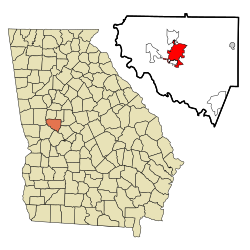
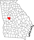
Thomaston is located near the center of Upson County at 32.90 N, -84.333333 W (32° 54′ 0″ N, 84° 20′ 0″ W). [9] The city is located in the west central Piedmont region of the state.
U.S. Route 19 is the main north–south route through the city, leading north 16 mi (26 km) to Zebulon and south 28 mi (45 km) to Butler. Georgia State Routes 36 and 74 are the main east–west routes through the city. GA-36 leads northeast 17 mi (27 km) to Barnesville and southwest 18 mi (29 km) to Woodland. GA-74 leads east 12 mi (19 km) to Yatesville and northwest 19 mi (31 km) to Woodbury.
Census | Pop. | Note | %± |
---|---|---|---|
1880 | 570 | — | |
1890 | 1,181 | 107.2% | |
1900 | 1,714 | 45.1% | |
1910 | 1,645 | −4.0% | |
1920 | 2,502 | 52.1% | |
1930 | 4,922 | 96.7% | |
1940 | 6,396 | 29.9% | |
1950 | 6,580 | 2.9% | |
1960 | 9,336 | 41.9% | |
1970 | 10,024 | 7.4% | |
1980 | 9,682 | −3.4% | |
1990 | 9,127 | −5.7% | |
2000 | 9,411 | 3.1% | |
2010 | 9,170 | −2.6% | |
2020 | 9,816 | 7.0% | |
U.S. Decennial Census [10] 1850-1870 [11] 1880 [12] 1890-1910 [13] 1920-1930 [14] 1930-1940 [15] 1940-1950 [16] 1960-1980 [17] 1990 [18] |
Race | Num. | Perc. |
---|---|---|
White (non-Hispanic) | 4,899 | 49.91% |
Black or African American (non-Hispanic) | 4,202 | 42.81% |
Native American | 21 | 0.21% |
Asian | 34 | 0.35% |
Pacific Islander | 1 | 0.01% |
Other/Mixed | 357 | 3.64% |
Hispanic or Latino | 302 | 3.08% |
As of the 2020 United States census, there were 9,816 people, 3,333 households, and 1,779 families residing in the city.
Its principal hospital is the Upson Regional Medical Center at 801 West Gordon Street.
Industry in the city is driven primarily by manufacturing which makes up 36.5%. The second largest industry is educational, health, and social service comprising 21.0%. The third largest industry is retail trade at 11.6% of the total industry in Thomaston. The remaining portions of industry include agriculture, construction, wholesale trade, transportation, information, finance, management, administration, arts and entertainment, food service, recreation, accommodation, and public administration.
The Upson County courthouse was built in 1908, and is listed on the National Register of Historic Places. [20]
Thomaston hosts an annual Emancipation Proclamation Celebration each May. It is the nation's oldest and longest running emancipation celebration of its kind. [7]
The Thomaston-Upson County School District holds pre-school to grade twelve, and consists of two elementary schools, a middle school, and a high school. [21] The district has 279 full-time teachers and over 5,009 students. [22]
Southern Crescent Technical College is located in Thomaston, and is a two-year technical school. [23] [24]
Upson County is a county located in the west central Piedmont portion of the U.S. state of Georgia. As of the 2020 census, the population was 27,700. The county seat is Thomaston. The county was created on December 15, 1824.
Monroe County is a county located in the central portion of the U.S. state of Georgia. As of the 2020 census, the population was 27,957. The county seat is Forsyth. The county was created on May 15, 1821. The county was named for James Monroe. Monroe County is included in the Macon, GA metropolitan statistical area.
Bleckley County is a county located in the central portion of the U.S. state of Georgia. As of the 2020 census, the population was 12,583. The county seat is Cochran.
Alma is a city in Bacon County, Georgia, United States, and the county seat. As of the 2020 census, the city had a population of 3,433.
Allentown is a city in Bleckley, Laurens, Twiggs, and Wilkinson counties in the U.S. state of Georgia, primarily in Wilkinson County. As of the 2010 census, the city had a population of 169, down from 287 at the 2000 census. In 2020, its population was 195. The Twiggs County portion is part of the Macon metropolitan statistical area, while the Laurens County portion is part of the Dublin micropolitan statistical area. The remaining Wilkinson and Bleckley County portions are not part of any metropolitan or micropolitan area.
Cochran is a city in Bleckley County, Georgia, United States. As of the 2020 census, the city had a population of 5,026. The city is the county seat of Bleckley County.
Loganville is a city in Walton and Gwinnett counties, Georgia, United States. The population was 10,458 at the 2010 census. Loganville is located about 36 mi (58 km) east of Atlanta and is part of the Atlanta metropolitan area.
Barnesville is a city in Lamar County, Georgia, United States. As of the 2010 census, the city had a population of 6,755, up from 5,972 at the 2000 census. The city is the county seat of Lamar County and is part of the Atlanta metropolitan area.
Smithville is a city in Lee County, Georgia, United States. The population was 593 in 2020. It is part of the Albany, Georgia metropolitan statistical area.
Culloden is a city in Monroe County, Georgia, United States. The population was 200 in the 2020 census. It is part of the Macon metropolitan statistical area.
The city of Lexington is the county seat of Oglethorpe County, Georgia, United States. The population was 239 at the 2000 census.
Hawkinsville is a city in and the county seat of Pulaski County, Georgia, United States. The population was 3,980 in 2020.
Sylvania is a city in and the county seat of Screven County, Georgia, United States. The population was 2,634 in 2020.
Talbotton is a city in Talbot County, Georgia, United States. The population was 970 at the 2010 census. The city is the county seat of Talbot County.
Butler is the county seat of Taylor County, Georgia, United States. Its population was 1,972 at the 2010 census, and 1,881 in 2020.
Lyons is a city in Toombs County, Georgia, United States. The population was 4,239 in 2020. The city is the county seat of Toombs County.
The city of Jeffersonville is the largest city and county seat of Twiggs County, Georgia, United States. The population was 1,035 at the 2010 census, down from 1,209 in 2000.
Salem is an unincorporated community and census-designated place (CDP) in Upson County, Georgia, United States. The population was 310 at the 2010 census.
Yatesville is a town in Upson County, Georgia, United States. The population was 408 at the 2000 census.
The Rock is an unincorporated community and census-designated place in Upson County, Georgia, United States. The Rock is located on Georgia State Route 36, 7 miles (11 km) northeast of Thomaston. The Rock has a post office with ZIP code 30285, although the post office is on the list to be closed. The Rock is also home to the area-famous Rock Ranch, a small theme park with a farming theme. The Rock is bordered by the cities of Barnesville, Hannahs Mill, Meansville, and Yatesville.