Sunset Village, Georgia

Last updated

Sunset Village, Georgia
Sunset Village, Georgia.jpg
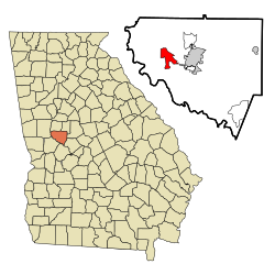
Upson County Georgia Incorporated and Unincorporated areas Sunset Village Highlighted.svg
Location in Upson County and the state of Georgia
Coordinates: 32°53′57″N84°24′34″W / 32.89917°N 84.40944°W / 32.89917; -84.40944
Country United States
State Georgia
County Upson
Area
[1]
  Total4.90 sq mi (12.68 km2)
  Land4.80 sq mi (12.44 km2)
  Water0.10 sq mi (0.25 km2)
Elevation
764 ft (233 m)
Population
 (2020)
  Total921
  Density191.84/sq mi (74.06/km2)
Time zone UTC-5 (Eastern (EST))
  Summer (DST) UTC-4 (EDT)
ZIP code
30286 [2]
Area code 706
FIPS code 13-74768 [3]
GNIS feature ID0323779 [4]

Sunset Village is an unincorporated community and census-designated place (CDP) in Upson County, Georgia, United States. The population was 871 at the 2000 census.

Contents

Geography

Sunset Village is located at 32°53′57″N84°24′34″W / 32.89917°N 84.40944°W / 32.89917; -84.40944 (32.899173, -84.409413). [5]

According to the United States Census Bureau, the CDP has a total area of 5.0 square miles (12.9 km2), of which 4.9 square miles (12.8 km2) is land and 0.1 square mile (0.1 km2) (1.01%) is water.

Demographics

Historical population
CensusPop.Note
2020 921
U.S. Decennial Census [6]

As of the census [3] of 2000, there were 871 people, 341 households, and 257 families residing in the CDP. The population density was 176.8 inhabitants per square mile (68.3/km2). There were 358 housing units at an average density of 72.7 per square mile (28.1/km2). The racial makeup of the CDP was 97.01% White, 2.53% African American, 0.23% Native American, and 0.23% from two or more races. Hispanic or Latino of any race were 0.46% of the population.

There were 341 households, out of which 34.0% had children under the age of 18 living with them, 61.3% were married couples living together, 9.4% had a female householder with no husband present, and 24.6% were non-families. 20.8% of all households were made up of individuals, and 7.6% had someone living alone who was 65 years of age or older. The average household size was 2.55 and the average family size was 2.96.

In the CDP, the population was spread out, with 26.9% under the age of 18, 6.1% from 18 to 24, 30.1% from 25 to 44, 24.7% from 45 to 64, and 12.3% who were 65 years of age or older. The median age was 36 years. For every 100 females, there were 91.4 males. For every 100 females age 18 and over, there were 86.8 males.

The median income for a household in the CDP was $34,487, and the median income for a family was $40,962. Males had a median income of $30,647 versus $21,850 for females. The per capita income for the CDP was $16,013. About 6.1% of families and 9.1% of the population were below the poverty line, including 11.4% of those under age 18 and none of those age 65 or over.

Related Research Articles

<span class="mw-page-title-main">Summit, Arizona</span> CDP in Pima County, Arizona

Summit is a census-designated place (CDP) in Pima County, Arizona, United States. The population was 3,702 at the 2000 census.

<span class="mw-page-title-main">Wilton, California</span> Census-designated place in California, United States

Wilton is a census-designated place (CDP) in Sacramento County, California, United States. It is part of the Sacramento–Arden-Arcade–Roseville Metropolitan Statistical Area. The population was 5,363 at the 2010 census, up from 4,551 at the 2000 census.

<span class="mw-page-title-main">Sunset, Florida</span> Census-designated place in Florida

Sunset is a census-designated place (CDP) in Miami-Dade County, Florida, United States. It is part of the Miami metropolitan area of South Florida. The population was 15,912 at the 2020 census. The U.S. Postal Service uses the ZIP Codes of 33173 and 33183 for Sunset.

<span class="mw-page-title-main">Westview, Florida</span> Census-designated place in Florida

Westview is a census-designated place (CDP) in Miami-Dade County, Florida, United States. It is part of the Miami metropolitan area of South Florida. The population was 9,923 at the 2020 census.

<span class="mw-page-title-main">Fort Benning South, Georgia</span> CDP in Georgia, United States

Fort Benning South is a former census-designated place (CDP) in Chattahoochee County, Georgia, United States. It is part of the Columbus, Georgia-Alabama Metropolitan Statistical Area. The population was 11,737 at the 2000 census. The area is now part of the consolidated city of Cusseta.

Pistakee Highlands is a census-designated place (CDP) in McHenry County, Illinois, United States. It consists primarily of an unincorporated area of McHenry County adjoining Pistakee Bay, within the McHenry post office, and is located just northeast of Johnsburg. Per the 2020 census, the population was 3,237.

<span class="mw-page-title-main">Bright, Indiana</span> Census-designated place in Indiana, United States

Bright is an unincorporated community and census-designated place (CDP) in Dearborn County, Indiana, United States. The population was 5,814 at the 2020 census.

<span class="mw-page-title-main">Westminster, Louisiana</span> Census-designated place in Louisiana, United States

Westminster is a census-designated place (CDP) in East Baton Rouge Parish, Louisiana, United States. The population was 3,008 at the 2010 census, up from 2,515 in 2000. It is part of the Baton Rouge Metropolitan Statistical Area.

<span class="mw-page-title-main">Dames Quarter, Maryland</span> CDP in Maryland, United States

Dames Quarter is a census-designated place (CDP) in Somerset County, Maryland, United States. The population was 188 at the 2000 census. It is included in the Salisbury, Maryland-Delaware Metropolitan Statistical Area.

<span class="mw-page-title-main">Seneca Knolls, New York</span> Census-designated place in New York, United States

Seneca Knolls is a hamlet in Onondaga County, New York, United States. The population was 2,011 at the 2010 census.

<span class="mw-page-title-main">Mount Carmel, Ohio</span> Census-designated place in Ohio, United States

Mount Carmel is a census-designated place (CDP) in Clermont County, Ohio, United States. The population was 4,828 at the 2020 census.

<span class="mw-page-title-main">Summerside, Ohio</span> Census-designated place in Ohio, United States

Summerside is a census-designated place (CDP) in Union Township, Clermont County, Ohio, United States. Its population was 4,941 as of the 2020 census.

Fort McKinley is an unincorporated community in Harrison Township in Montgomery County, Ohio, United States. It was delineated as a census-designated place (CDP) at the 2000 census, when its population was 3,989. It was not delineated as a CDP for the 2010 census.

<span class="mw-page-title-main">Christie, Oklahoma</span> CDP in Oklahoma, United States

Christie is a census-designated place (CDP) in Adair County, Oklahoma, United States. The population was 218 at the 2010 census, a 31.3 percent increase over the figure of 166 recorded in 2000.

<span class="mw-page-title-main">Elim, Pennsylvania</span> Census-designated place in Pennsylvania, United States

Elim is an unincorporated community and census-designated place (CDP) in Upper Yoder Township, Cambria County, Pennsylvania, United States. The population was 3,727 at the 2010 census, down from 4,175 at the 2000 census.

Woodland Heights is a census-designated place (CDP) in Venango County, Pennsylvania, United States. The population was 1,402 at the 2000 census.

<span class="mw-page-title-main">Lasana, Texas</span> Census-designated place in Texas, United States

Lasana is a census-designated place (CDP) in Cameron County, Texas, United States. The population was 84 at the 2010 census, down from 135 at the 2000 census. It is part of the Brownsville–Harlingen Metropolitan Statistical Area.

<span class="mw-page-title-main">North Sultan, Washington</span> CDP in Washington, United States

North Sultan is a census-designated place (CDP) in Snohomish County, Washington, United States. The population was 264 at the 2010 census.

<span class="mw-page-title-main">Loveland Park, Ohio</span> Census-designated place in Ohio, United States

Loveland Park is a census-designated place (CDP) located in Symmes Township, Hamilton County and Deerfield Township, Warren County, in the southwestern part of the U.S. state of Ohio. The CDP is named after the city of Loveland. The population was 1,737 at the 2020 census.

<span class="mw-page-title-main">Ipswich (CDP), Massachusetts</span> Census-designated place in Massachusetts, United States

Ipswich is a census-designated place (CDP) located in the town of Ipswich in Essex County, Massachusetts, United States. The population was 4,222 at the 2010 census.

References

  1. "2020 U.S. Gazetteer Files". United States Census Bureau. Retrieved December 18, 2021.
  2. "Sunset Village ZIP Code". zipdatamaps.com. 2023. Retrieved January 12, 2023.
  3. 1 2 "U.S. Census website". United States Census Bureau . Retrieved January 31, 2008.
  4. "US Board on Geographic Names". United States Geological Survey. October 25, 2007. Retrieved January 31, 2008.
  5. "US Gazetteer files: 2010, 2000, and 1990". United States Census Bureau. February 12, 2011. Retrieved April 23, 2011.
  6. "Census of Population and Housing". Census.gov. Retrieved June 4, 2016.