Lincoln Park, Georgia | |
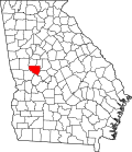
---|---|
Coordinates: 32°52′4″N84°19′55″W / 32.86778°N 84.33194°W | |
Country | United States |
State | Georgia |
County | Upson |
Area | |
• Total | 0.86 sq mi (2.24 km2) |
• Land | 0.86 sq mi (2.22 km2) |
• Water | 0.01 sq mi (0.02 km2) |
Elevation | 715 ft (218 m) |
Population (2020) | |
• Total | 817 |
• Density | 953.33/sq mi (368.08/km2) |
Time zone | UTC-5 (Eastern (EST)) |
• Summer (DST) | UTC-4 (EDT) |
ZIP code | 30286 [2] |
Area code | 706 |
FIPS code | 13-46524 [3] |
GNIS feature ID | 0332218 [4] |
Lincoln Park is an unincorporated community and census-designated place (CDP) in Upson County, Georgia, United States. The population was 1,122 at the 2000 census.
Lincoln Park is located at 32°52′4″N84°19′55″W / 32.86778°N 84.33194°W (32.867666, -84.332046). [5]
According to the United States Census Bureau, the CDP has a total area of 1.0 square mile (2.6 km2), all land.
Census | Pop. | Note | %± |
---|---|---|---|
1950 | 1,575 | — | |
1960 | 1,840 | 16.8% | |
1970 | 1,852 | 0.7% | |
1980 | 1,755 | −5.2% | |
2000 | 1,122 | — | |
2010 | 833 | −25.8% | |
2020 | 817 | −1.9% | |
U.S. Decennial Census [6] 1850-1870 [7] 1870-1880 [8] 1890-1910 [9] 1920-1930 [10] 1940 [11] 1950 [12] 1960 [13] 1970 [14] 1980 [15] 1990 [16] 2000 [17] 2010 [18] 2020 [19] |
Lincoln Park was first listed as an unincorporated place in the 1950 U.S. Census [12] and designated a CDP in the 1980 U.S. Census. It was not listed in the 1990 U.S. Census [17] after a portion of the CDP was annexed to Thomastown. [20] It reappeared as a CDP in the 2000 U.S. Census.
Race / Ethnicity (NH = Non-Hispanic) | Pop 2000 [21] | Pop 2010 [18] | Pop 2020 [19] | % 2000 | % 2010 | % 2020 |
---|---|---|---|---|---|---|
White alone (NH) | 50 | 61 | 65 | 4.46% | 7.32% | 7.96% |
Black or African American alone (NH) | 1,058 | 759 | 720 | 94.30% | 91.12% | 88.13% |
Native American or Alaska Native alone (NH) | 1 | 2 | 1 | 0.09% | 0.24% | 0.12% |
Asian alone (NH) | 3 | 4 | 1 | 0.27% | 0.48% | 0.12% |
Pacific Islander alone (NH) | 0 | 1 | 0 | 0.00% | 0.12% | 0.00% |
Some Other Race alone (NH) | 0 | 2 | 10 | 0.00% | 0.24% | 1.22% |
Mixed Race or Multi-Racial (NH) | 1 | 2 | 11 | 0.09% | 0.24% | 1.35% |
Hispanic or Latino (any race) | 9 | 2 | 9 | 0.80% | 0.24% | 1.10% |
Total | 1,122 | 833 | 817 | 100.00% | 100.00% | 100.00% |
Upson County is a county located in the west central Piedmont portion of the U.S. state of Georgia. As of the 2020 census, the population was 27,700. The county seat is Thomaston. The county was created on December 15, 1824.
Talbot County is a county located in the west central portion of the U.S. state of Georgia. The 2020 census showed a population of 5,733. The county seat and largest city is Talbotton.
Lamar County is a county located in the west central portion of the U.S. state of Georgia. As of the 2020 census, the population was 18,500. The county seat is Barnesville.
Bonanza is an unincorporated community and census-designated place (CDP) in Clayton County, Georgia, United States. The population was 3,135 at the 2010 census.
Irondale is an unincorporated community and census-designated place (CDP) in Clayton County, Georgia, United States. The population was 8,740 at the 2020 census.
Evans is an unincorporated community and census-designated place (CDP) in Columbia County, Georgia, United States. It is a suburb of Augusta and is part of the Augusta metropolitan area. The population was 29,011 at the 2010 census, up from 17,727 at the 2000 census.
Belvedere Park is an unincorporated community and census-designated place (CDP) in DeKalb County, Georgia, United States. The population was 15,113 at the 2020 census.
Candler-McAfee is an unincorporated community and census-designated place (CDP) in DeKalb County, Georgia, United States. It is located east of Atlanta approximately 10 miles (16 km) east of Downtown Atlanta and to the south of Decatur, Georgia The population was 23,025 at the 2010 census.
Gresham Park is an unincorporated community and census-designated place (CDP) in DeKalb County, Georgia, United States. The population was 7,700 at the 2020 census.
Mountain Park is an unincorporated community and census-designated place (CDP) in Gwinnett County, Georgia, United States. The population was 11,554 at the 2010 census. The older name for the area is Trickum, which is reflected in Five Forks-Trickum Road which bisects the community. The older community was centered on Five Forks and Rockbridge Roads.
Coleman is a former incorporated city in Randolph County, Georgia, United States. It is listed as a census-designated place (CDP). The population was 149 at the 2000 census. The city was abolished by House Bill 1102 effective January 1, 2007, and no longer exists as a municipality.
Lakeview Estates, also known as Sunrise Lakes by local residents, is an unincorporated community and census-designated place (CDP) in Rockdale County, Georgia, United States. The population was 2,637 at the 2000 census.
Hiltonia is a city in Screven County, Georgia, United States. The population was 310 in 2020.
Experiment is an unincorporated community and census-designated place (CDP) in Spalding County, Georgia, United States. The population was 3,233 at the 2000 census.
Hannahs Mill is an unincorporated community and census-designated place (CDP) in Upson County, Georgia, United States. The population was 3,267 at the 2000 census.
Salem is an unincorporated community and census-designated place (CDP) in Upson County, Georgia, United States. The population was 310 at the 2010 census.
Sunset Village is an unincorporated community and census-designated place (CDP) in Upson County, Georgia, United States. The population was 871 at the 2000 census.
Deenwood is an unincorporated community and census-designated place (CDP) in Ware County, Georgia, United States. The population was 2,207 at the 2020 census. It is part of the Waycross micropolitan statistical area. Deenwood Baptist Church is named after this geographical area.
Cataula is an unincorporated community and census-designated place (CDP) in Harris County, Georgia, United States.
The Rock is an unincorporated community and census-designated place in Upson County, Georgia, United States. The Rock is located on Georgia State Route 36, 7 miles (11 km) northeast of Thomaston. The Rock has a post office with ZIP code 30285, although the post office is on the list to be closed. The Rock is also home to the area-famous Rock Ranch, a small theme park with a farming theme. The Rock is bordered by the cities of Barnesville, Hannahs Mill, Meansville, and Yatesville.
Upson County—Annexations: Thomaston city, Yatesville town. Deleted CDP's: Hannahs Mill and Lincoln Park (both partially annexed by Thomaston city).