Woodbury, Georgia

Last updated

Woodbury, Georgia
WOODBURY, GEORGIA.jpg
"A Peach of a Place"
Meriwether County Georgia Incorporated and Unincorporated areas Woodbury Highlighted.svg
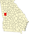
Location in Meriwether County and the state of Georgia
Coordinates: 32°58′50″N84°34′52″W / 32.98056°N 84.58111°W / 32.98056; -84.58111
Country United States
State Georgia
County Meriwether
Area
[1]
  Total2.10 sq mi (5.44 km2)
  Land2.07 sq mi (5.36 km2)
  Water0.03 sq mi (0.08 km2)
Elevation
827 ft (252 m)
Population
 (2020) [2]
  Total908
  Density438.86/sq mi (169.47/km2)
Time zone UTC-5 (Eastern (EST))
  Summer (DST) UTC-4 (EDT)
ZIP code
30293
Area code 706
FIPS code 13-83896 [3]
GNIS feature ID0333457 [4]
Website www.cityofwoodburyga.gov

Woodbury is a city in Meriwether County, Georgia, United States. The population was 908 at the 2020 census. [2]

Contents

History

The Georgia General Assembly incorporated Woodbury in 1913. [5] The community most likely was named after Levi Woodbury (1789–1851), American justice on the United States Supreme Court. [6]

Geography

Woodbury is located in southeastern Meriwether County at 32°58′50″N84°34′52″W / 32.98056°N 84.58111°W / 32.98056; -84.58111 (32.980588, -84.580979). [7] Georgia State Routes 18, 74, 85, and 109 pass through the city. Route 18 leads northwest 8 miles (13 km) to Greenville, the county seat, and northeast 19 miles (31 km) to Zebulon. Route 74 goes east out of Woodbury with Route 18 but leads southeast 19 miles (31 km) to Thomaston; to the north Route 74 leads 8 miles (13 km) to Gay. Route 85 goes north to Gay with Route 74 but also leads south 10 miles (16 km) to Manchester. Route 85 Alternate runs through the north side of Woodbury and leads southwest 9 miles (14 km) to Warm Springs. Route 109 follows Route 18 both northwest and east out of Woodbury but leads east 28 miles (45 km) to Barnesville.

According to the United States Census Bureau, Woodbury has a total area of 2.1 square miles (5.4 km2), of which 0.03 square miles (0.08 km2), or 1.43%, are water. [1] The Flint River passes 3 miles (5 km) east of the city, and Pine Mountain rises three miles to the south.

Demographics

Historical population
CensusPop.Note
1880 94
1890 369292.6%
1900 56653.4%
1910 91762.0%
1920 9230.7%
1930 849−8.0%
1940 8651.9%
1950 98513.9%
1960 1,23024.9%
1970 1,42215.6%
1980 1,73822.2%
1990 1,429−17.8%
2000 1,184−17.1%
2010 961−18.8%
2020 908−5.5%
U.S. Decennial Census [8]
The Red Oak Creek Covered Bridge is located just north of Woodbury. Built in the 1840s by the famed Georgia bridge builder, Horace King, with its approaches the Red Oak Covered Bridge is the longest in Georgia and the only one of King's bridges that is still in use today. It was added to the National Register of Historic Places on May 7, 1973. Red Oak Creek Bridge, Spanning (Big) Red Oak Creek, Huel Brown Road (Cov, Woodbury vicinity (Meriwether County, Georgia)).jpg
The Red Oak Creek Covered Bridge is located just north of Woodbury. Built in the 1840s by the famed Georgia bridge builder, Horace King, with its approaches the Red Oak Covered Bridge is the longest in Georgia and the only one of King's bridges that is still in use today. It was added to the National Register of Historic Places on May 7, 1973.
Woodbury racial composition as of 2020 [9]
RaceNum.Perc.
White (non-Hispanic)34838.33%
Black or African American (non-Hispanic)50455.51%
Native American 20.22%
Asian 10.11%
Pacific Islander 10.11%
Other/Mixed 363.96%
Hispanic or Latino 161.76%

As of the 2020 United States census, there were 908 people, 456 households, and 260 families residing in the city.

Related Research Articles

<span class="mw-page-title-main">Upson County, Georgia</span> County in Georgia, United States

Upson County is a county located in the west central Piedmont portion of the U.S. state of Georgia. As of the 2020 census, the population was 27,700. The county seat is Thomaston. The county was created on December 15, 1824.

<span class="mw-page-title-main">Talbot County, Georgia</span> County in Georgia, United States

Talbot County is a county located in the west central portion of the U.S. state of Georgia. The 2020 census showed a population of 5,733. The county seat and largest city is Talbotton.

<span class="mw-page-title-main">Meriwether County, Georgia</span> County in Georgia, United States

Meriwether County is a county located in the west central portion of the U.S. state of Georgia. As of the 2020 census, the population was 20,613. The county seat is Greenville, home of the Meriwether County Courthouse. The county was formed on December 14, 1827, as the 73rd county in Georgia. It was named for David Meriwether, a general in the American Revolutionary War and member of Congress from Georgia.

<span class="mw-page-title-main">Harris County, Georgia</span> County in Georgia, United States

Harris County is a county located in the west-central portion of the U.S. state of Georgia; its western border with the state of Alabama is formed by the Chattahoochee River. As of the 2020 census, the population was 34,668. The county seat is Hamilton. The largest city in the county is Pine Mountain, a resort town that is home to the Franklin D. Roosevelt State Park. Harris County was created on December 14, 1827, and named for Charles Harris, a Georgia judge and attorney.

<span class="mw-page-title-main">Cusseta, Georgia</span> Consolidated city-county in Georgia, United States

Cusseta is a city in Chattahoochee County, Georgia, United States. It is part of the Columbus, Georgia-Alabama metropolitan statistical area. The population was 9,565 in 2020. The city is the county seat of Chattahoochee County, with which it shares a consolidated city-county government. Despite this, Cusseta is not coterminous with the county; it remains a geographically distinct municipality within the county.

<span class="mw-page-title-main">Grantville, Georgia</span> City in Georgia, United States

Grantville is a city in Coweta County, Georgia, United States. The 2010 census shows a population of 3,041.

<span class="mw-page-title-main">Haralson, Georgia</span> Town in Georgia, United States

Haralson is a town in Coweta and Meriwether counties in the U.S. state of Georgia. The population was 172 at the 2020 census. It is noted for being one of the filming locations for both The Walking Dead and Lawless.

<span class="mw-page-title-main">Swainsboro, Georgia</span> City in Georgia, United States

Swainsboro is a city in Emanuel County, Georgia, United States. As of the 2020 census, the city had a population of 7,425. The city is the county seat of Emanuel County.

<span class="mw-page-title-main">Pine Mountain, Harris County, Georgia</span> Town in Georgia, United States

Pine Mountain is a town in Harris and Meriwether counties in the U.S. state of Georgia. As of the 2020 census it had a population of 1,216.

<span class="mw-page-title-main">Waverly Hall, Georgia</span> Town in Georgia, United States

Waverly Hall is a town in Harris County, Georgia, United States. It is part of the Columbus, Georgia-Alabama metropolitan statistical area. The population was 638 in 2020.

<span class="mw-page-title-main">Oglethorpe, Georgia</span> City in Georgia, United States

Oglethorpe is a city in Macon County, Georgia, United States. The population was 995 at the 2020 census, down from 1,328 in 2010. The city is the county seat of Macon County. It was named for Georgia's founder, James Oglethorpe.

<span class="mw-page-title-main">Gay, Georgia</span> Town in Georgia, United States

Gay is a town in Meriwether County, Georgia, United States. The population was 110 at the 2020 census.

<span class="mw-page-title-main">Greenville, Georgia</span> City in Georgia, United States

Greenville is a city and the county seat of Meriwether County, Georgia, United States. The population was 794 at the 2020 census, down from 876 in 2010. The city is located 60 miles (97 km) southwest of Atlanta and is part of the Atlanta metropolitan area.

<span class="mw-page-title-main">Luthersville, Georgia</span> City in Georgia, United States

Luthersville is a city in Meriwether County, Georgia, United States. The population was 776 at the 2020 census, down from 874 in 2010.

<span class="mw-page-title-main">Manchester, Georgia</span> City in Georgia, United States

Manchester is a town in Meriwether and Talbot counties in the U.S. state of Georgia, although primarily in Meriwether. The population was 3,584 at the 2020 census, down from 4,230 in 2010. It is the most populous community in Meriwether County. CSX Transportation runs a railroad yard in Manchester.

<span class="mw-page-title-main">Warm Springs, Georgia</span> City in the United States

Warm Springs is a city in Meriwether County, Georgia, United States. The population was 465 at the 2020 census.

<span class="mw-page-title-main">Culloden, Georgia</span> City in Georgia, United States

Culloden is a city in Monroe County, Georgia, United States. The population was 200 in the 2020 census. It is part of the Macon metropolitan statistical area.

<span class="mw-page-title-main">Butler, Georgia</span> City in Georgia, United States

Butler is the county seat of Taylor County, Georgia, United States. Its population was 1,972 at the 2010 census, and 1,881 in 2020.

<span class="mw-page-title-main">Thomaston, Georgia</span> City in Georgia, United States

Thomaston is a city in and the county seat of Upson County, Georgia, United States. The population was 9,170 at the 2010 census. It is the principal city of and is included in the Thomaston, Georgia Micropolitan Statistical Area, which is included in the Atlanta - Sandy Springs (GA) - Gainesville (GA) - Alabama (partial) CSA.

<span class="mw-page-title-main">Georgia State Route 74</span> Highway in Georgia

State Route 74 (SR 74) is a 108-mile-long (174 km) state highway that runs southeast-to-northwest through portions of Bibb, Monroe, Upson, Pike, Meriwether, Coweta, Fayette, and Fulton counties in the central part of the U.S. state of Georgia. The route connects the Macon and Fairburn, via Thomaston, Woodbury, and Peachtree City.

References

  1. 1 2 "2022 U.S. Gazetteer Files: Georgia". United States Census Bureau. Retrieved January 26, 2023.
  2. 1 2 "P1. Race – Woodbury city, Georgia: 2020 DEC Redistricting Data (PL 94-171)". U.S. Census Bureau. Retrieved January 26, 2023.
  3. "U.S. Census website". United States Census Bureau . Retrieved January 31, 2008.
  4. "US Board on Geographic Names". United States Geological Survey. October 25, 2007. Retrieved January 31, 2008.
  5. "Woodbury". GeorgiaGov. Retrieved June 30, 2019.
  6. Krakow, Kenneth K. (1975). Georgia Place-Names: Their History and Origins (PDF). Macon, GA: Winship Press. p. 256. ISBN   0-915430-00-2.
  7. "US Gazetteer files: 2010, 2000, and 1990". United States Census Bureau. February 12, 2011. Retrieved April 23, 2011.
  8. "Census of Population and Housing". Census.gov. Retrieved June 4, 2015.
  9. "Explore Census Data". data.census.gov. Retrieved December 14, 2021.
  10. "The Walking Dead". IMDb . Retrieved July 6, 2016.