Alps, Georgia | |
|---|---|
 Alps  Alps | |
| Coordinates: 33°8′53″N84°36′12″W / 33.14806°N 84.60333°W | |
| Country | United States |
| State | Georgia |
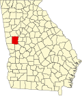
| County | Meriwether |
| Elevation | 850 ft (260 m) |
| Time zone | UTC-5 (Eastern (EST)) |
| • Summer (DST) | UTC-4 (EDT) |
| GNIS feature ID | 354290 [1] |
Alps is an unincorporated community located in Meriwether County, Georgia, United States.
A post office called Alps was established in 1890, and remained in operation until 1910. [2] The community was located inland away from the railroads. [3]