Meriwether County, Georgia | |
|---|---|
| Meriwether County Courthouse in Greenville | |
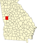
| Location within the U.S. state of Georgia | |
| Coordinates: 33°02′N84°41′W / 33.04°N 84.69°W | |
| Country | |
| State | |
| Founded | 1827 |
| Named after | David Meriwether |
| Seat | Greenville |
| Largest city | Manchester |
| Area | |
• Total | 505 sq mi (1,310 km2) |
| • Land | 501 sq mi (1,300 km2) |
| • Water | 4.2 sq mi (11 km2) 0.8% |
| Population (2020) | |
• Total | 20,613 [1] |
| Time zone | UTC−5 (Eastern) |
| • Summer (DST) | UTC−4 (EDT) |
| Congressional district | 3rd |
| Website | meriwethercountyga.gov |
Meriwether County is a county in the West Central region of the U.S. state of Georgia. As of the 2020 census, the population was 20,613. [2] [1] The county seat is Greenville, [3] home of the Meriwether County Courthouse. The county was formed on December 14, 1827, as the 73rd county in Georgia. It was named for David Meriwether, a general in the American Revolutionary War and member of Congress from Georgia. [4]
Meriwether County is part of the Atlanta-Sandy Springs-Roswell MSA.
According to the U.S. Census Bureau, the county has a total area of 505 square miles (1,310 km2), of which 501 square miles (1,300 km2) is land and 4.2 square miles (11 km2) (0.8%) is water. [5]
The county is located in the Piedmont region of the state. Portions of the Pine Mountain Range are found in the southern parts of the county near the cities of Warm Springs and Manchester.
The eastern two-thirds of Meriwether County, going east from just west of U.S. Route 27 Alternate, is located in the Upper Flint River sub-basin of the ACF River Basin (Apalachicola-Chattahoochee-Flint River Basin). The western third of the county is located in the Middle Chattahoochee River-Lake Harding sub-basin of the same ACF River Basin. [6]
| Census | Pop. | Note | %± |
|---|---|---|---|
| 1830 | 4,422 | — | |
| 1840 | 14,132 | 219.6% | |
| 1850 | 16,476 | 16.6% | |
| 1860 | 15,330 | −7.0% | |
| 1870 | 13,756 | −10.3% | |
| 1880 | 17,651 | 28.3% | |
| 1890 | 20,740 | 17.5% | |
| 1900 | 23,339 | 12.5% | |
| 1910 | 25,180 | 7.9% | |
| 1920 | 26,167 | 3.9% | |
| 1930 | 22,437 | −14.3% | |
| 1940 | 22,055 | −1.7% | |
| 1950 | 21,055 | −4.5% | |
| 1960 | 19,756 | −6.2% | |
| 1970 | 19,461 | −1.5% | |
| 1980 | 21,229 | 9.1% | |
| 1990 | 22,411 | 5.6% | |
| 2000 | 22,534 | 0.5% | |
| 2010 | 21,992 | −2.4% | |
| 2020 | 20,613 | −6.3% | |
| 2024 (est.) | 21,439 | [7] | 4.0% |
| U.S. Decennial Census [8] 1790-1880 [9] 1890-1910 [10] 1920-1930 [11] 1930-1940 [12] 1940-1950 [13] 1960-1980 [14] 1980-2000 [15] 2010 [2] 2020 [1] | |||
As of the 2020 census, the county had a population of 20,613. The median age was 46.2 years. 19.8% of residents were under the age of 18 and 21.7% of residents were 65 years of age or older. For every 100 females there were 91.9 males, and for every 100 females age 18 and over there were 89.8 males age 18 and over. 0.0% of residents lived in urban areas, while 100.0% lived in rural areas. [16] [17]
The racial makeup of the county was 59.3% White, 35.3% Black or African American, 0.3% American Indian and Alaska Native, 0.4% Asian, 0.0% Native Hawaiian and Pacific Islander, 1.0% from some other race, and 3.6% from two or more races. Hispanic or Latino residents of any race comprised 2.3% of the population. [18]
| Race | Num. | Perc. |
|---|---|---|
| White (non-Hispanic) | 12,084 | 58.62% |
| Black or African American (non-Hispanic) | 7,273 | 35.28% |
| Native American | 64 | 0.31% |
| Asian | 78 | 0.38% |
| Pacific Islander | 6 | 0.03% |
| Other/Mixed | 633 | 3.07% |
| Hispanic or Latino | 475 | 2.3% |
There were 8,396 households in the county, of which 26.3% had children under the age of 18 living with them and 31.4% had a female householder with no spouse or partner present. About 28.2% of all households were made up of individuals and 13.6% had someone living alone who was 65 years of age or older. [17]
There were 9,456 housing units, of which 11.2% were vacant. Among occupied housing units, 72.5% were owner-occupied and 27.5% were renter-occupied. The homeowner vacancy rate was 1.5% and the rental vacancy rate was 7.3%. [17]
Meriwether County is a moderately Republican county, voting 62% for Donald Trump in 2024. The last Democrat to win the county in a presidential election was Al Gore in 2000. For elections to the United States House of Representatives, Meriwether County is part of Georgia's 3rd congressional district, currently represented by Brian Jack. For elections to the Georgia State Senate, Meriwether County is part of District 29. [20] For elections to the Georgia House of Representatives, Meriwether County is part of districts 136 and 137. [21]
| Year | Republican | Democratic | Third party(ies) | |||
|---|---|---|---|---|---|---|
| № | % | № | % | № | % | |
| 1912 | 26 | 2.66% | 862 | 88.05% | 91 | 9.30% |
| 1916 | 36 | 2.88% | 1,118 | 89.44% | 96 | 7.68% |
| 1920 | 186 | 14.94% | 1,059 | 85.06% | 0 | 0.00% |
| 1924 | 103 | 7.74% | 886 | 66.57% | 342 | 25.69% |
| 1928 | 287 | 15.93% | 1,515 | 84.07% | 0 | 0.00% |
| 1932 | 53 | 1.99% | 2,604 | 97.82% | 5 | 0.19% |
| 1936 | 138 | 5.36% | 2,438 | 94.61% | 1 | 0.04% |
| 1940 | 174 | 5.98% | 2,726 | 93.74% | 8 | 0.28% |
| 1944 | 189 | 7.95% | 2,187 | 92.05% | 0 | 0.00% |
| 1948 | 204 | 8.47% | 1,967 | 81.65% | 238 | 9.88% |
| 1952 | 531 | 13.01% | 3,551 | 86.99% | 0 | 0.00% |
| 1956 | 592 | 15.88% | 3,137 | 84.12% | 0 | 0.00% |
| 1960 | 706 | 18.55% | 3,100 | 81.45% | 0 | 0.00% |
| 1964 | 2,250 | 48.14% | 2,423 | 51.84% | 1 | 0.02% |
| 1968 | 1,120 | 20.55% | 1,760 | 32.29% | 2,571 | 47.17% |
| 1972 | 3,420 | 73.82% | 1,213 | 26.18% | 0 | 0.00% |
| 1976 | 1,450 | 23.09% | 4,830 | 76.91% | 0 | 0.00% |
| 1980 | 1,838 | 31.66% | 3,876 | 66.77% | 91 | 1.57% |
| 1984 | 3,195 | 52.73% | 2,864 | 47.27% | 0 | 0.00% |
| 1988 | 3,101 | 51.31% | 2,934 | 48.54% | 9 | 0.15% |
| 1992 | 2,364 | 32.30% | 4,002 | 54.67% | 954 | 13.03% |
| 1996 | 2,259 | 36.13% | 3,492 | 55.85% | 502 | 8.03% |
| 2000 | 3,162 | 47.13% | 3,441 | 51.29% | 106 | 1.58% |
| 2004 | 4,402 | 53.98% | 3,709 | 45.48% | 44 | 0.54% |
| 2008 | 4,982 | 52.34% | 4,465 | 46.91% | 71 | 0.75% |
| 2012 | 4,856 | 52.36% | 4,331 | 46.70% | 87 | 0.94% |
| 2016 | 5,222 | 56.47% | 3,804 | 41.13% | 222 | 2.40% |
| 2020 | 6,524 | 59.96% | 4,287 | 39.40% | 69 | 0.63% |
| 2024 | 7,375 | 62.26% | 4,373 | 36.92% | 98 | 0.83% |
The county is served by the Meriwether Vindicator newspaper.