Quitman County | |
---|---|
Coordinates: 31°52′N85°01′W / 31.86°N 85.01°W | |
Country | United States |
State | Georgia |
Founded | December 10, 1858 |
Named for | John A. Quitman |
Seat | Georgetown |
Largest city | Georgetown |
Area | |
• Total | 161 sq mi (420 km2) |
• Land | 151 sq mi (390 km2) |
• Water | 9.3 sq mi (24 km2) 5.8% |
Population (2020) | |
• Total | 2,235 |
• Density | 15/sq mi (6/km2) |
Time zone | UTC−5 (Eastern) |
• Summer (DST) | UTC−4 (EDT) |
Congressional district | 2nd |
Quitman County is a county located in the southwestern part of the U.S. state of Georgia. As of the 2020 census, the population was 2,235, [1] making it the second-least populous county in Georgia. The county seat is Georgetown. [2] The county was created on December 10, 1858, and named after General John A. Quitman, leader in the Mexican–American War, and once Governor of Mississippi. In November 2006, residents voted to consolidate the city government of Georgetown and the county government of Quitman into a consolidated city-county.
According to the U.S. Census Bureau, the county has a total area of 161 square miles (420 km2), of which 151 square miles (390 km2) is land and 9.3 square miles (24 km2) (5.8%) is water. [3] The entirety of Quitman County is located in the Middle Chattahoochee River–Walter F. George Lake sub-basin of the ACF River Basin (Apalachicola-Chattahoochee-Flint River Basin). [4]
Census | Pop. | Note | %± |
---|---|---|---|
1860 | 3,499 | — | |
1870 | 4,150 | 18.6% | |
1880 | 4,392 | 5.8% | |
1890 | 4,471 | 1.8% | |
1900 | 4,701 | 5.1% | |
1910 | 4,594 | −2.3% | |
1920 | 3,417 | −25.6% | |
1930 | 3,820 | 11.8% | |
1940 | 3,435 | −10.1% | |
1950 | 3,015 | −12.2% | |
1960 | 2,432 | −19.3% | |
1970 | 2,180 | −10.4% | |
1980 | 2,357 | 8.1% | |
1990 | 2,209 | −6.3% | |
2000 | 2,598 | 17.6% | |
2010 | 2,513 | −3.3% | |
2020 | 2,235 | −11.1% | |
2023 (est.) | 2,280 | [5] | 2.0% |
U.S. Decennial Census [6] 1790-1880 [7] 1890-1910 [8] 1920-1930 [9] 1930-1940 [10] 1940-1950 [11] 1960-1980 [12] 1980-2000 [13] 2010 [14] |
Race | Num. | Perc. |
---|---|---|
White | 1,190 | 53.24% |
Black or African American | 917 | 41.03% |
Native American | 13 | 0.58% |
Asian | 12 | 0.54% |
Other/Mixed | 72 | 3.22% |
Hispanic or Latino | 31 | 1.39% |
As of the 2020 United States census, there were 2,235 people, 842 households, and 577 families residing in the county.
Quitman County School District operates area public schools, including Quitman County High School.
County students attended Stewart-Quitman High School (now Stewart County High School) from 1978, until Quitman County High opened, [16] in 2009.[ citation needed ]
Year | Republican | Democratic | Third party | |||
---|---|---|---|---|---|---|
No. | % | No. | % | No. | % | |
2020 | 604 | 54.61% | 497 | 44.94% | 5 | 0.45% |
2016 | 575 | 55.08% | 461 | 44.16% | 8 | 0.77% |
2012 | 510 | 45.21% | 612 | 54.26% | 6 | 0.53% |
2008 | 509 | 45.61% | 597 | 53.49% | 10 | 0.90% |
2004 | 409 | 42.38% | 543 | 56.27% | 13 | 1.35% |
2000 | 348 | 38.50% | 542 | 59.96% | 14 | 1.55% |
1996 | 224 | 28.11% | 514 | 64.49% | 59 | 7.40% |
1992 | 284 | 30.80% | 523 | 56.72% | 115 | 12.47% |
1988 | 296 | 40.11% | 436 | 59.08% | 6 | 0.81% |
1984 | 361 | 42.42% | 490 | 57.58% | 0 | 0.00% |
1980 | 240 | 28.67% | 589 | 70.37% | 8 | 0.96% |
1976 | 313 | 31.62% | 677 | 68.38% | 0 | 0.00% |
1972 | 502 | 78.19% | 140 | 21.81% | 0 | 0.00% |
1968 | 90 | 12.05% | 198 | 26.51% | 459 | 61.45% |
1964 | 377 | 62.11% | 230 | 37.89% | 0 | 0.00% |
1960 | 67 | 14.73% | 388 | 85.27% | 0 | 0.00% |
1956 | 31 | 8.03% | 355 | 91.97% | 0 | 0.00% |
1952 | 93 | 21.88% | 332 | 78.12% | 0 | 0.00% |
1948 | 19 | 5.26% | 246 | 68.14% | 96 | 26.59% |
1944 | 16 | 4.31% | 355 | 95.69% | 0 | 0.00% |
1940 | 19 | 5.54% | 324 | 94.46% | 0 | 0.00% |
1936 | 19 | 5.08% | 355 | 94.92% | 0 | 0.00% |
1932 | 0 | 0.00% | 239 | 98.35% | 4 | 1.65% |
1928 | 41 | 19.07% | 174 | 80.93% | 0 | 0.00% |
1924 | 8 | 5.33% | 138 | 92.00% | 4 | 2.67% |
1920 | 4 | 2.88% | 135 | 97.12% | 0 | 0.00% |
1916 | 15 | 10.56% | 125 | 88.03% | 2 | 1.41% |
1912 | 7 | 4.27% | 152 | 92.68% | 5 | 3.05% |
From the 1940s to 1960s Joe Hurst dominated politics in Quitman County, delivering votes for statewide officials, state judges, and prosecuting attorneys, under the County unit system which gave Quitman two units, a third as many as the biggest counties in the state. He hand-delivered state welfare checks and prevented secret ballots. In 1962 he stuffed the ballot box for future President Jimmy Carter's opponent in a state senate primary. Carter won a series of court cases to remove his Democratic primary opponent's name from the general election ballot. There was no Republican candidate. Both candidates used radio ads to ask voters to vote by write-in, and Carter won the general election. Hurst was later convicted of fraud in an earlier primary, for which he had a fine and three years probation. He was also convicted of selling moonshine, for which he went to prison. [18] [19]
Webster County is a county located in the west central portion of the U.S. state of Georgia. As of the 2020 census reflected a population of 2,348, making it the third-least populous county in Georgia. The county seat is Preston.
Talbot County is a county located in the west central portion of the U.S. state of Georgia. The 2020 census showed a population of 5,733. The county seat and largest city is Talbotton.
Sumter County is a county located in the west-central portion of the U.S. state of Georgia. As of the 2020 census, its population was 29,616. The county seat is Americus. The county was created on December 26, 1831.
Stewart County is a county located in the west central portion of the U.S. state of Georgia. As of the 2020 census, the population was 5,314. The county seat is Lumpkin. The county was created on December 23, 1830.
Spalding County is a county located in the west central portion of the U.S. state of Georgia. As of the 2020 census, the population was 67,306. The county seat is Griffin. The county was created December 20, 1851, and named for former United States representative and senator Thomas Spalding.
Seminole County is a county located in the southwestern corner of U.S. state of Georgia. As of the 2020 census, the population was 9,147. The county seat is Donalsonville.
Richmond County is located in the state of Georgia in the U.S. As of the 2020 census, the population was 206,607. It is one of the original counties of Georgia, created on February 5, 1777. Following an election in 1995, Augusta consolidated governments with Richmond County. The consolidated entity is known as Augusta-Richmond County, or simply Augusta. Exempt are the cities of Hephzibah and Blythe, in southern Richmond County, which voted to remain separate. Richmond County is included in the Augusta-Richmond County, GA-SC metropolitan statistical area.
Randolph County is a county located in the southwestern portion of the U.S. state of Georgia and is considered part of the Black Belt, historically an area of plantations. As of the 2020 census, the population was 6,425, roughly one-third of its peak population in 1910, when there were numerous agricultural workers. The county seat is Cuthbert.
Pike County is a county located in the west central portion of the U.S. state of Georgia. As of the 2020 census, the population was 18,889. The county seat is Zebulon.
Peach County is a county located in the central portion of the U.S. state of Georgia. As of the 2020 census, the population was 27,981. Its county seat is Fort Valley. Founded in 1924, it is the state's newest county, taken from Houston and Macon counties on July 18 of that year. Its namesake is the peach on account of it being located in a peach-growing district.
Muscogee County is a county located on the central western border of the U.S. state of Georgia named after the Muscogee that originally inhabited the land with its western border with the state of Alabama that is formed by the Chattahoochee River. As of the 2020 census, the population was 206,922. Its county seat and only city is Columbus, with which it has been a consolidated city-county since the beginning of 1971.
Monroe County is a county located in the central portion of the U.S. state of Georgia. As of the 2020 census, the population was 27,957. The county seat is Forsyth. The county was created on May 15, 1821. The county was named for James Monroe. Monroe County is included in the Macon, GA metropolitan statistical area.
Marion County is a county located in the west central portion of the U.S. state of Georgia. As of the 2020 census, the county had a population of 7,498. The county seat is Buena Vista. The county was created on December 14, 1827. The county was named for General Francis Marion of South Carolina.
Lee County is a county located in the U.S. state of Georgia. As of the 2020 census, the population was 33,163. The county was established in 1825 and its county seat is Leesburg. Lee County is included in the Albany, GA metropolitan statistical area.
Houston County is a county located in the central portion of the U.S. state of Georgia. The population was 163,633 at the 2020 census. Its county seat is Perry; the city of Warner Robins is substantially larger in both area and population.
Hall County is a county located in the northeast portion of the U.S. state of Georgia. As of the 2020 census, the population was 203,136, up from 179,684 at the 2010 census. The county seat is Gainesville. The entirety of Hall County comprises the Gainesville, Georgia, Metropolitan Statistical Area, which is also part of the Atlanta-Athens-Clarke County-Sandy Springs, Combined Statistical Area.
Dooly County is a county located in the central portion of the U.S. state of Georgia. As of the 2020 census, the population was 11,208. The county seat is Vienna. The county was created by an act of the Georgia General Assembly on May 15, 1821, and named for Colonel John Dooly, a Georgia American Revolutionary War fighter. It was one of the original landlot counties created from land ceded from the Creek Nation.
Colquitt County is a county in the U.S. state of Georgia. As of the 2020 census, the population was 45,898. The county seat is Moultrie. The county was created on February 25, 1856, and is named for Walter Terry Colquitt, a U.S. senator. Colquitt County comprises the Moultrie, GA micropolitan statistical area.
Chattahoochee County, also known as Cusseta-Chattahoochee County, is a county located on the western border in central Georgia. As of the 2020 census, the population was 9,565. The county seat is Cusseta, with which the county shares a consolidated city-county government. The city of Cusseta remains a geographically distinct municipality within Chattahoochee County. The county was created on February 13, 1854.
Georgetown is a city in Quitman County, Georgia
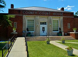
, United States. It is on the Alabama-Georgia state line next to Walter F. George Lake and across the Chattahoochee River from Eufaula, Alabama. Per the 2020 census, the population was 2,235. In 2006, Georgetown and Quitman County voted to consolidate their governments, becoming the smallest such consolidated entity in the Lower 48 states.