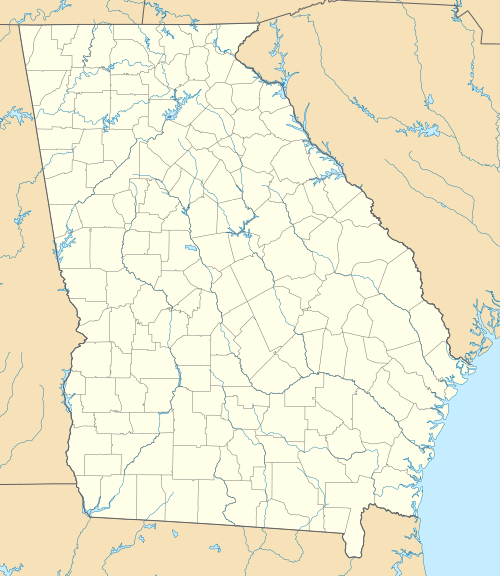
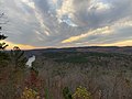
List of Georgia state parks

Last updated

USA Georgia location map.svg
Green pog.svg
Green pog.svg
Green pog.svg
Green pog.svg
Green pog.svg
Green pog.svg
Green pog.svg
Green pog.svg
Green pog.svg
Green pog.svg
Green pog.svg
Green pog.svg
Green pog.svg
Green pog.svg
Green pog.svg
Green pog.svg
Green pog.svg
Green pog.svg
Green pog.svg
Green pog.svg
Green pog.svg
Green pog.svg
Green pog.svg
Green pog.svg
Green pog.svg
Green pog.svg
Green pog.svg
Green pog.svg
Green pog.svg
Green pog.svg
Green pog.svg
Green pog.svg
Green pog.svg
Green pog.svg
Green pog.svg
Green pog.svg
Green pog.svg
Green pog.svg
Green pog.svg
Green pog.svg
Green pog.svg
Green pog.svg
Green pog.svg
Green pog.svg
Green pog.svg
Green pog.svg
Green pog.svg
Green pog.svg
Green pog.svg
Green pog.svg
Green pog.svg
Green pog.svg
Green pog.svg
Green pog.svg
Green pog.svg
Green pog.svg
Green pog.svg
Green pog.svg
Green pog.svg
Green pog.svg
Green pog.svg
Green pog.svg
Green pog.svg
Location of Georgia’s 49 state parks

This is a list of state parks in Georgia. The park system of the US state of Georgia was founded in 1931 with Indian Springs State Park and Vogel State Park. Indian Springs has been operated by the state as a public park since 1825, making it perhaps the oldest state park in the United States. [1] The newest state park is Don Carter State Park. [2]

Contents

Since the economic crash of 2008, Georgia has halved the budget for the Division of State Parks and Historic Sites and turned over the management of five of the parks to Coral Hospitality, a Florida-based hotel and resort management company. The five parks are Amicalola Falls State Park & Lodge, Unicoi State Park & Lodge, Little Ocmulgee State Park & Lodge, Georgia Veterans State Park, and George T. Bagby State Park. [3]

State parks

Park nameCounty or countiesSizeYear established [4] Location Water body(s)ImageRemarks
acresha
A.H. Stephens State Park Taliaferro 1,1774761933 33°33′44.16″N82°53′44.56″W / 33.5622667°N 82.8957111°W / 33.5622667; -82.8957111 Alexander Stevens State Park Lake Stephens Monument.JPG
Amicalola Falls State Park & Lodge Dawson 8293351940 34°34′34.11″N84°14′10.5″W / 34.5761417°N 84.236250°W / 34.5761417; -84.236250 Amicalola Falls Amicalola Falls 01.jpg
Black Rock Mountain State Park Rabun 1,7437051952 34°54′34″N83°24′55″W / 34.90944°N 83.41528°W / 34.90944; -83.41528 Black Rock Lake Black Rock Mountain State Park view, August 2017 1.jpg
Chattahoochee Bend State Park [5] Coweta 2,9101,1802011 33°25′58.05″N84°59′10.13″W / 33.4327917°N 84.9861472°W / 33.4327917; -84.9861472 Chattahoochee River Chattahoochee Bend State Park.jpg
Cloudland Canyon State Park Dade 3,4881,4121938 34°48′57.96″N85°29′21.12″W / 34.8161000°N 85.4892000°W / 34.8161000; -85.4892000 Hemlock Falls Cloudland Waterfall 2.jpg
Crooked River State Park Camden 5002001939 30°50′35″N81°33′29″W / 30.84306°N 81.55806°W / 30.84306; -81.55806 Intracoastal Waterway 1994 Crooked River Sunset (612001088).jpg
Don Carter State Park [2] Hall 1,3165332013 34°23′5.44″N83°44′35.68″W / 34.3848444°N 83.7432444°W / 34.3848444; -83.7432444 Lake Lanier
Elijah Clark State Park Lincoln 4471811953 33°51′16.2″N82°25′10.54″W / 33.854500°N 82.4195944°W / 33.854500; -82.4195944 Clarks Hill Lake Sunset clarkshill-lake.jpg
F. D. Roosevelt State Park Harris, Meriwether 9,0493,6621938 32°49′55″N84°48′29″W / 32.83194°N 84.80806°W / 32.83194; -84.80806 Dowdell knob.JPG
Florence Marina State Park Stewart 173701985 32°5′26.88″N85°2′35.99″W / 32.0908000°N 85.0433306°W / 32.0908000; -85.0433306 Walter F. George Lake Florence state park.JPG
Fort McAllister State Park Bryan 1,7256981980 31°53′28″N81°11′46″W / 31.89111°N 81.19611°W / 31.89111; -81.19611 Ogeechee River & Atlantic Ocean GA Richmond Hill Fort McAllister inside01.jpg
Fort Mountain State Park Murray 3,7121,5021938 34°45′39.3″N84°42′25.8″W / 34.760917°N 84.707167°W / 34.760917; -84.707167 Fort Mountain Lake Fort mountain, Georgia wall 2016.JPG
Fort Yargo State Park Barrow 1,8167351954 33°58′10.64″N83°43′46.6″W / 33.9696222°N 83.729611°W / 33.9696222; -83.729611 Fort Yargo Lake Fort Yargo State Park lake view.jpg
General Coffee State Park Coffee 1,5116111970 31°31′26.4″N82°46′1.2″W / 31.524000°N 82.767000°W / 31.524000; -82.767000 17 04 035 general coffee.jpg
George L. Smith State Park Emanuel 1,6346611975 32°33′43.2″N82°6′46.8″W / 32.562000°N 82.113000°W / 32.562000; -82.113000 Parish Pond GLSmith-SP Entrance.jpg
George T. Bagby State Park Clay 7002801970 31°39′57.6″N85°3′25.2″W / 31.666000°N 85.057000°W / 31.666000; -85.057000 Walter F. George Lake 2011.05.21.080736 George T. Bagby SP Fort Gaines Georgia USA.jpg
Georgia Veterans State Park Crisp 1,3085291946 31°57′23″N83°54′58″W / 31.95639°N 83.91611°W / 31.95639; -83.91611 Lake Blackshear Clay Pit Rd entrance, Georgia Veterans State Park.JPG
Jack Hill State Park Tattnall 6622681956 32°5′31.51″N82°8′9.61″W / 32.0920861°N 82.1360028°W / 32.0920861; -82.1360028 Altamaha River
Hamburg State Park Warren 7413001968 33°12′28.37″N82°47′20.05″W / 33.2078806°N 82.7889028°W / 33.2078806; -82.7889028 Hamburg Mill Pond 17 12 057 hamburg.jpg
Hard Labor Creek State Park Morgan 5,8042,3491946 33°39′49.88″N83°36′22.15″W / 33.6638556°N 83.6061528°W / 33.6638556; -83.6061528 Hard Labor Creek
High Falls State Park Monroe 1,0504201966 33°10′44.31″N84°1′10.73″W / 33.1789750°N 84.0196472°W / 33.1789750; -84.0196472 Towaliga River 15-20-184, high falls - panoramio.jpg
Indian Springs State Park Butts 5282141825 33°14′38″N83°55′52″W / 33.24389°N 83.93111°W / 33.24389; -83.93111 Sandy Creek 17 08 099 indian springs.jpg
James H. Floyd State Park Chattooga 5612271973 34°26′13.83″N85°20′22.47″W / 34.4371750°N 85.3395750°W / 34.4371750; -85.3395750 Sloppy Floyd Lake James H. Floyd State Park 1.JPG
Kolomoki Mounds State Park Early 1,2935231938 31°28′17.28″N84°55′45.72″W / 31.4714667°N 84.9293667°W / 31.4714667; -84.9293667 Yahola & Kolomoki Lakes Kolomoki-temple-mound.jpg
Laura S. Walker State Park Ware 6262531941 31°8′10.67″N82°12′36.3″W / 31.1362972°N 82.210083°W / 31.1362972; -82.210083 Laura S. Walker Lake Laura S Walker State Park.jpg
Little Ocmulgee State Park & Lodge Telfair 1,3605501935 32°5′32.17″N82°53′49.11″W / 32.0922694°N 82.8969750°W / 32.0922694; -82.8969750 Little Ocmulgee Lake L-Ocmulgee-SP.jpg
Magnolia Springs State Park Jenkins 1,0704301939 32°53′12″N81°57′20″W / 32.88667°N 81.95556°W / 32.88667; -81.95556 Magnolia Springs State Park Lake Magnolia Springs State Park, Jenkins County, GA, US.jpg
Mistletoe State Park Columbia 1,9207801965 33°38′37.56″N82°23′2.7″W / 33.6437667°N 82.384083°W / 33.6437667; -82.384083 Clarks Hill Lake
Moccasin Creek State Park Rabun 32131966 34°49′36.84″N83°33′18.36″W / 34.8269000°N 83.5551000°W / 34.8269000; -83.5551000 Lake Burton Lake Burton with boat.jpg
Panola Mountain State Park Henry 1,6356621974 33°38′7″N84°10′13″W / 33.63528°N 84.17028°W / 33.63528; -84.17028 Alexander Lake & South River Panola.JPG
Providence Canyon State Outdoor Recreation Area Stewart 1,0034061971 32°3′47.44″N84°55′11.58″W / 32.0631778°N 84.9198833°W / 32.0631778; -84.9198833 Providence Canyon from rim.jpg
Red Top Mountain State Park Bartow 1,7767191950 34°9′5.4″N84°42′55.8″W / 34.151500°N 84.715500°W / 34.151500; -84.715500 Lake Allatoona Red Top Mountain State Park 1.JPG
Reed Bingham State Park Colquitt 1,6136531958 31°10′14.49″N83°33′16.98″W / 31.1706917°N 83.5547167°W / 31.1706917; -83.5547167 Reed Bingham Lake Reed Bingham Park lake 1.JPG
Richard B. Russell State Park Elbert 2,5081,0151987 34°10′41.09″N82°45′40.89″W / 34.1780806°N 82.7613583°W / 34.1780806; -82.7613583 Russell Lake Richard B. Russell State Park.jpg
Seminole State Park Seminole 6042441956 30°48′18.61″N84°52′44.2″W / 30.8051694°N 84.878944°W / 30.8051694; -84.878944 Lake Seminole Seminole State Park sign.jpg
Skidaway Island State Park Chatham 5882381975 31°56′13.41″N81°3′7.98″W / 31.9370583°N 81.0522167°W / 31.9370583; -81.0522167 Intracoastal Waterway Skidaway Island State Park.jpg
Smithgall Woods State Park White 5,6642,2921994 34°41′30.57″N83°46′4.71″W / 34.6918250°N 83.7679750°W / 34.6918250; -83.7679750 Dukes Creek Lodge at Smithgall Woods Conservation Area, April 2017.jpg
Standing Boy Creek State Park Muscogee 1,5796392004 32°34′20.33″N85°2′10.77″W / 32.5723139°N 85.0363250°W / 32.5723139; -85.0363250 Lake Oliver
Stephen C. Foster State Park Charlton 80321954 30°49′35.86″N82°22′45.9″W / 30.8266278°N 82.379417°W / 30.8266278; -82.379417 Suwannee River Cypresses on the water.jpg
Sweetwater Creek State Park Douglas 2,5491,0321972 33°45′30″N84°38′10″W / 33.75833°N 84.63611°W / 33.75833; -84.63611 Sweetwater Creek Sweetwater Creek (Chattahoochee River) 2013.JPG
Tallulah Gorge State Park Rabun, Habersham 2,7391,1081993 34°43′30″N83°22′13″W / 34.72500°N 83.37028°W / 34.72500; -83.37028 Tallulah River Tallulah Gorge view from an overlook, May 2017 1.jpg
Tugaloo State Park Franklin 3931591965 34°29′41.37″N83°4′4.54″W / 34.4948250°N 83.0679278°W / 34.4948250; -83.0679278 Lake Hartwell Tugaloo State Park Beach.jpg
Unicoi State Park & Lodge White 1,0504201954 34°43′22.92″N83°43′20.28″W / 34.7230333°N 83.7223000°W / 34.7230333; -83.7223000 Unicoi Lake Unicoi State Park lake, October 2014 2.JPG
Victoria Bryant State Park Franklin 5022031952 34°18′4.23″N83°9′35.52″W / 34.3011750°N 83.1598667°W / 34.3011750; -83.1598667 North Fork of the Broad River
Vogel State Park Union 233941927 34°45′46″N83°55′40″W / 34.76278°N 83.92778°W / 34.76278; -83.92778 Lake Trahlyta Lake Trahlyta, Vogel State Park, Oct 2016 1.jpg
Watson Mill Bridge State Park Madison 1,1184521969 34°1′34″N83°4′23″W / 34.02611°N 83.07306°W / 34.02611; -83.07306 South Fork of the Broad River Watson mill state park.jpg

Historic sites

Park nameCounty or CountiesSizeYear established [6] Location ImageRemarks
acresha
Chief Vann House State Historic Site Murray 137551952 34°45′47.21″N84°49′19.14″W / 34.7631139°N 84.8219833°W / 34.7631139; -84.8219833 Chief Vann House, Sept 2017.jpg
Dahlonega Gold Museum State Historic Site Lumpkin .2640.1071966 34°31′57.62″N83°59′5.46″W / 34.5326722°N 83.9848500°W / 34.5326722; -83.9848500 Dahlonega Gold Museum Historic Site.jpg
Etowah Indian Mounds State Historic Site Bartow 54221953 34°7′40.83″N84°48′25.42″W / 34.1280083°N 84.8070611°W / 34.1280083; -84.8070611 USA-Georgia-Etowah Indian Mounds-Mound B.jpg
Fort King George State Historic Site McIntosh 124.91940 31°21′59.18″N81°24′57.13″W / 31.3664389°N 81.4158694°W / 31.3664389; -81.4158694 Fort King George front, McIntosh County, GA, US.jpg
Fort Morris State Historic Site Liberty 67271968 31°45′36.2″N81°17′22.14″W / 31.760056°N 81.2894833°W / 31.760056; -81.2894833 Fort Morris mounds (Midway, GA).JPG
Hardman Farm State Historic Site [7] White 173702014 34°41′5.97″N83°42′29.73″W / 34.6849917°N 83.7082583°W / 34.6849917; -83.7082583 17 22 390 hardman.jpg
Hofwyl-Broadfield Plantation State Historic Site Glynn 1,2865201974 31°18′18.09″N81°27′19.83″W / 31.3050250°N 81.4555083°W / 31.3050250; -81.4555083 Hofwyl-Broadfield Plantation, back view, Glynn County, GA, US.jpg
Jarrell Plantation State Historic Site Monroe 200811974 33°2′53.29″N83°43′9.93″W / 33.0481361°N 83.7194250°W / 33.0481361; -83.7194250 JPmillComplex (3).JPG
Jefferson Davis Memorial State Historic Site Irwin 135.31997 31°39′52.38″N83°23′12.07″W / 31.6645500°N 83.3866861°W / 31.6645500; -83.3866861 JEFFERSON DAVIS CAPTURE SITE.jpg
Lapham-Patterson House State Historic Site Thomas 10.401971 30°50′44.2″N83°58′58.45″W / 30.845611°N 83.9829028°W / 30.845611; -83.9829028 Thomasville GA Lapham-Patterson vpano02.jpg
Little White House State Historic Site Meriwether 163661948 32°52′52.99″N84°41′15.48″W / 32.8813861°N 84.6876333°W / 32.8813861; -84.6876333 USA-Georgia-Warm Springs-Roosevelt's Little White House.JPG
New Echota State Historic Site Gordon 200811962 34°32′27.55″N84°54′33.59″W / 34.5409861°N 84.9093306°W / 34.5409861; -84.9093306 Council House, New Echota, GA July 2017.jpg
Pickett's Mill Battlefield State Historic Site Paulding 7653101974 33°58′26.41″N84°45′32.93″W / 33.9740028°N 84.7591472°W / 33.9740028; -84.7591472 Pickett's Mill Battlefield Site, Paulding County, Georgia by George Paul Puvvada.jpg
Reynolds Mansion on Sapelo Island McIntosh 6,1102,470 31°23′49.57″N81°16′37.38″W / 31.3971028°N 81.2770500°W / 31.3971028; -81.2770500 RJ Reynolds mansion, Sapelo Island, GA, US.jpg
Robert Toombs House State Historic Site Wilkes 4.341.761982 33°44′10.07″N82°44′1.91″W / 33.7361306°N 82.7338639°W / 33.7361306; -82.7338639 Robert Toombs Home-Washington, Georgia.jpg
Traveler's Rest State Historic Site Stephens 5.12.11955 34°36′33.26″N83°14′19.73″W / 34.6092389°N 83.2388139°W / 34.6092389; -83.2388139 Traveler's Rest, Toccoa.jpg
Wormsloe State Historic Site Chatham 1,2324991973 31°58′48.69″N81°4′9.26″W / 31.9801917°N 81.0692389°W / 31.9801917; -81.0692389 Wormsloe Historic Site, Chatham County, GA, US (36).jpg

Former state parks

Park nameCounty or CountiesSizeYear establishedYear disestablished Location ImageRemarks
acresha
Chehaw State Park Dougherty 80032019371977 31°37′3.44″N84°8′17.17″W / 31.6176222°N 84.1381028°W / 31.6176222; -84.1381028 In 1974, the city of Albany leased 100 acres (40 ha) of unused land in Chehaw Park from the state of Georgia to develop a wild animal park where exotic and indigenous animals would be displayed in their natural habitats. With the inception of the wild animal habitat, the State donated the entire Chehaw Park acreage to the city to further develop.
Bobby Brown State Park Elbert 6652691950s2015 33°58′26.93″N82°34′43.6″W / 33.9741472°N 82.578778°W / 33.9741472; -82.578778 The park was established on the waters of the newly constructed Clark Hills Lake in the 1950s. It was downgraded to Bobby Brown State Outdoor Recreation Area in 2009. In 2015, a lease agreement was reached with the United States Army Corps of Engineers. The park is now operated by the government of Elbert County, Georgia. [8]
George Washington Carver State Park Bartow 34514019501975 34°8′20.86″N84°40′1.06″W / 34.1391278°N 84.6669611°W / 34.1391278; -84.6669611 Bartow Carver Park 2016.JPG It was established during segregation on land adjacent to Red Top Mountain State Park and billed as Georgia's first state park for African Americans. It was removed from the state park system due to budget cuts, turned over to Bartow County, and renamed Bartow Carver Park. It returned to its original name in 2017. [9]
Hart State Park Hart 1475919682020 34°22′35.16″N82°54′38.4″W / 34.3764333°N 82.910667°W / 34.3764333; -82.910667 In April 2020, management of the park passed from the Georgia Department of Natural Resources to the City of Hartwell. [10] In June 2020, a groundbreaking ceremony was officially held for the renamed Hartwell Lakeside Park. [11]
Jekyll Island State Park Glynn 5,7002,30019471950 31°4′12″N81°25′13″W / 31.07000°N 81.42028°W / 31.07000; -81.42028 It was formerly a state park, but since 1951 it has been managed by the Jekyll Island Authority, a self-supporting state agency.
John Tanner State Park Carroll 1385619712013 33°36′7.92″N85°10′3.72″W / 33.6022000°N 85.1677000°W / 33.6022000; -85.1677000 Operated from 1954 to 1971 as Tanner's Beach, it was purchased by the state in 1971, and opened in 1972. It became managed by Carroll County in 2010 and was purchased by Carroll County in 2013. [12]
Santo Domingo State Park Glynn 19341946 31°19′37.28″N81°29′13.13″W / 31.3270222°N 81.4869806°W / 31.3270222; -81.4869806 The state of Georgia conveyed the Santo Domingo State Park property to J. Ardell Nation in 1946. Ardell established the Boys Estate, an orphanage for homeless boys modeled upon Boys Town, Nebraska. [13] The former property of the Boys Estate is now run by Morningstar Children and Family Services. [14]
Sprewell Bluff State Park Upson 1,37255519932013 31°52′15.85″N84°28′26.15″W / 31.8710694°N 84.4739306°W / 31.8710694; -84.4739306 Sprewell Bluff Park.jpg It was a state park leased from Georgia Power. In 2013, Upson County, Georgia took over management of the property and it was de-listed. [15]

Other

Images

See also

Related Research Articles

<span class="mw-page-title-main">Atlanta</span> Capital city of Georgia, United States

Atlanta is the capital and most populous city of the U.S. state of Georgia. It is the seat of Fulton County, the most populous county in Georgia, although a portion of the city extends into neighboring DeKalb County. With a population of 498,715 living within the city limits, it is the eighth most populous city in the Southeast and 38th most populous city in the United States according to the 2020 U.S. census. It is the core of the much larger Atlanta metropolitan area, which is home to more than 6.1 million people, making it the eighth-largest metropolitan area in the United States. Situated among the foothills of the Appalachian Mountains at an elevation of just over 1,000 feet (300 m) above sea level, it features unique topography that includes rolling hills, lush greenery, and the most dense urban tree coverage of any major city in the United States.

<span class="mw-page-title-main">Georgia (U.S. state)</span> U.S. state

Georgia is a state in the Southeastern region of the United States, bordered to the north by Tennessee and North Carolina; to the northeast by South Carolina; to the southeast by the Atlantic Ocean; to the south by Florida; and to the west by Alabama. Georgia is the 24th-largest state in area and 8th most populous of the 50 United States. Its 2020 population was 10,711,908, according to the U.S. Census Bureau. Atlanta, a "beta(+)" global city, is both the state's capital and its largest city. The Atlanta metropolitan area, with a population of more than 6 million people in 2021, is the 8th most populous metropolitan area in the United States and contains about 57% of Georgia's entire population.

<span class="mw-page-title-main">Gwinnett County, Georgia</span> County in Georgia, United States

Gwinnett County is located in the north central portion of the U.S. state of Georgia. It forms part of the Atlanta metropolitan area. In 2020, the population was 957,062, making it the second-most populous county in Georgia. Its county seat is Lawrenceville. The county is named for Button Gwinnett, one of the signatories of the Declaration of Independence.

<span class="mw-page-title-main">Cobb County, Georgia</span> County in Georgia, United States

Cobb County is a county in the U.S. state of Georgia, located in the Atlanta metropolitan area in the north central portion of the state. As of 2020 Census, the population was 766,149. Its county seat and largest city is Marietta.

<span class="mw-page-title-main">Ball Ground, Georgia</span> City in Georgia, United States

Ball Ground is a city in Cherokee County, Georgia, United States. The city was originally Cherokee territory before they were removed from the land and it was given to white settlers. A railroad was built in 1882 and a town was formed around the resulting railroad stop. The town was incorporated on January 1, 1883, and became an industrial-based economy largely centered around its marble industry until around the mid-20th century when the industries began to leave and the city started to decline. From 2000 onwards the city saw rapid growth; as of the 2020 census the city had a population of 2,560, which is over three times the city's population of 730 in 2000.

<span class="mw-page-title-main">Alpharetta, Georgia</span> City in Georgia, United States

Alpharetta is a city in northern Fulton County, Georgia, United States, and is a part of the Atlanta metropolitan area. As of the 2020 US Census, Alpharetta's population was 65,818; in 2010, the population was 57,551.

<span class="mw-page-title-main">State park</span> Protected area managed at the federated state level

State parks are parks or other protected areas managed at the sub-national level within those nations which use "state" as a political subdivision. State parks are typically established by a state to preserve a location on account of its natural beauty, historic interest, or recreational potential. There are state parks under the administration of the government of each U.S. state, some of the Mexican states, and in Brazil. The term is also used in the Australian states of Victoria and New South Wales. The equivalent term used in Canada, Argentina, South Africa, and Belgium, is provincial park. Similar systems of local government maintained parks exist in other countries, but the terminology varies.

<span class="mw-page-title-main">Little White House</span> Historic house in Georgia, United States

The Little White House was the personal retreat of Franklin D. Roosevelt, the 32nd President of the United States, located in the Historic District of Warm Springs, Georgia. He first came to Warm Springs in 1924 for polio treatment, and liked the area so much that, as Governor of New York, he had a home built on nearby Pine Mountain. The house was finished in 1932. Roosevelt kept the house after he became President, using it as a presidential retreat. He died there on April 12, 1945, three months into his fourth term.

<span class="mw-page-title-main">Mount Kineo</span>

Mount Kineo is a prominent geological feature located on a 1,150-acre (470 ha) peninsula that extends from the easterly shore of Moosehead Lake in the northern forest of Maine. With 700-foot (210 m) cliffs rising straight up from the water, it is the central feature of Mount Kineo State Park, a protected area of 800 acres (320 ha) managed by the Maine Department of Agriculture, Conservation and Forestry.

<span class="mw-page-title-main">Disney's River Country</span> Former water park at Walt Disney World Resort

Disney's River Country was the first water park at Walt Disney World. River Country was located along the shores of Bay Lake and near Disney's Fort Wilderness Resort & Campground, the park was themed as a rustic, old-fashioned swimming hole. It opened on June 20, 1976, and closed indefinitely on November 2, 2001, with The Walt Disney Company later announcing on January 20, 2005, that the park would remain closed permanently. This made the water park the second of only two Disney parks in the company's history to close permanently, with nearby Discovery Island on the lake closing in 1999. A new hotel, Reflections – A Disney Lakeside Lodge, was set to be built at the former site of Disney's River Country starting in 2019 and was planned to open in 2022, but construction was halted during the COVID-19 pandemic.

<span class="mw-page-title-main">Scouting in Georgia (U.S. state)</span>

Scouting in Georgia has a long history, from the 1910s to the present day, serving thousands of youth in programs that suit the environment in which they live. The state is home to many milestones for the Scouting movement. The Girl Scout Birthplace is located in Savannah, and President Jimmy Carter served as a Scoutmaster in Plains, Georgia.

<span class="mw-page-title-main">Callaway Gardens</span> Resort complex in Pine Mountain, Georgia, U.S.

Callaway Resort & Gardens is a 2,500-acre (1,000 ha) resort complex located near Pine Mountain in Harris County, Georgia, 18 miles (29 km) from LaGrange, Georgia. The world's largest azalea garden, this destination draws over 750,000 visitors annually. Callaway Gardens was ranked as Best Georgia Attraction in 2018 by USA Today.

<span class="mw-page-title-main">Wakulla Springs</span> Spring and cave in the Floridan Aquifer under the Woodville Karst Plain of north Florida

Wakulla Springs is located 14 miles (23 km) south of Tallahassee, Florida and 5 miles (8.0 km) east of Crawfordville in Wakulla County, Florida at the crossroads of State Road 61 and State Road 267. It is protected in the Edward Ball Wakulla Springs State Park.

Hartwell Lakeside Park, formerly known as Hart State Park, is a 147 acres (59 ha) park in Hartwell, in northeast Georgia. The park is named after the American Revolutionary War heroine Nancy Hart, who lived in the Georgia frontier, and it was her devotion to freedom that has helped make her name commonplace in the Georgia upcountry.

Great Wolf Resorts is a chain of indoor water parks. The company owns and operates its family resorts under the Great Wolf Lodge brand. In addition to a water park, each resort features restaurants, arcades, spas, and children's activities. Great Wolf Resorts is headquartered in Chicago, Illinois.

<span class="mw-page-title-main">Crater Lake Lodge</span> United States historic place

Crater Lake Lodge is a hotel built in 1915 to provide overnight accommodations for visitors to Crater Lake National Park in southern Oregon, US. The lodge is located on the southwest rim of the Crater Lake caldera overlooking the lake 1,000 feet (300 m) below. The lodge is owned by the National Park Service, and is listed on the National Register of Historic Places. In 2022, the hotel is a Historic Hotels of America program member, and has been so since 2012.

<span class="mw-page-title-main">Ponce de Leon Springs (Atlanta)</span> Former mineral springs in Atlanta, Georgia

Ponce de Leon Springs was a mineral spring in Atlanta, Georgia, in the United States. The spring was a popular tourist destination from the mid-1800s through the early 1900s. Around the turn of the century, the land surrounding the spring was developed into an amusement park. By the 1920s, the amusement park was demolished, and the area was developed for industrial and, later, commercial properties.

<span class="mw-page-title-main">Historic Hotels of America</span> National Trust for Historic Preservation program

Historic Hotels of America is a program of the National Trust for Historic Preservation that was founded in 1989 with 32 charter members; the program accepts nominations and identifies hotels that have maintained their authenticity, sense of place, and architectural integrity. In 2015, the program included over 260 members in 44 states, including the District of Columbia, Puerto Rico, and the U.S. Virgin Islands. In 2022, the program includes 273 hotels. This article lists current and former member hotels.

References

  1. "Indian Springs State Park History" (PDF). Georgia State Parks. Georgia. Archived (PDF) from the original on January 8, 2023. Retrieved December 14, 2022.
  2. 1 2 "Don Carter State Park". State Parks & Historic Sites. February 21, 2017. Archived from the original on September 22, 2017. Retrieved September 24, 2017.
  3. Omarzu, Tim (May 29, 2013). "Georgia tries to balance cuts with need to draw visitors to state parks". TimesFreePress.com. Archived from the original on September 26, 2017. Retrieved September 25, 2017.
  4. "History of the Georgia State Parks and Historic Sites Division" (PDF). Georgia State Parks. Georgia. Archived (PDF) from the original on January 8, 2023. Retrieved December 13, 2022.
  5. "Chattahoochee Bend State Park". State Parks & Historic Sites. March 3, 2017. Archived from the original on October 1, 2017. Retrieved September 24, 2017.
  6. "History of the Georgia State Parks and Historic Sites Division" (PDF). Georgia State Parks. Georgia. Archived (PDF) from the original on January 8, 2023. Retrieved December 13, 2022.
  7. "The Georgia Trust". www.georgiatrust.org. Archived from the original on September 23, 2017. Retrieved September 24, 2017.
  8. "Bobby Brown Park". Explore Georgia. Archived from the original on December 6, 2022. Retrieved October 11, 2022.
  9. "George Washington Carver State Park". Visit Carterville, GA. 2022. Archived from the original on December 14, 2022. Retrieved December 14, 2022.
  10. "Hartwell Lakeside Park". Georgia Department of Natural Resources. Archived from the original on December 7, 2022. Retrieved October 11, 2022.
  11. Grayson Williams (June 24, 2020). "Let the camping begin: Ceremonial groundbreaking launches Hartwell Lakeside". Hartwell Sun. Archived from the original on May 20, 2021. Retrieved October 11, 2022.
  12. Hall, Christine (September 27, 2013). "Carroll sees green with improved green spaces". Atlanta Business Chronicle. Atlanta. Archived from the original on February 6, 2023. Retrieved December 14, 2022.
  13. "Estate to Make Men". Atlanta Constitution. Atlanta, Georgia. March 17, 1946.
  14. "History of the Georgia State Parks and Historic Sites Division" (PDF). Georgia State Parks. Georgia. Archived (PDF) from the original on January 8, 2023. Retrieved December 13, 2022.
  15. "Sprewell Bluff Park". upsoncountyga.org. Archived from the original on November 19, 2018. Retrieved November 18, 2018.