Darien is a city in McIntosh County, Georgia, United States. It lies on Georgia's coast at the mouth of the Altamaha River, approximately 50 miles south of Savannah, and is part of the Brunswick, Georgia Metropolitan Statistical Area. The population of Darien was 1,975 at the 2010 census. The city is the county seat of McIntosh County. It is the second oldest planned city in Georgia and was originally called New Inverness.

The Province of Georgia was one of the Southern colonies in British America. It was the last of the thirteen original American colonies established by Great Britain in what later became the United States. In the original grant, a narrow strip of the province extended to the Pacific Ocean.
The Battle of Alligator Bridge took place on June 30, 1778, and was the only major engagement in an unsuccessful campaign to conquer British East Florida during the American Revolutionary War. A detachment of Georgia militiamen under the command of General James Screven chased Thomas Brown's Loyalist company into a large position of British regulars established by British Major Mark Prevost and were turned back.

The Castillo de San Marcos is the oldest masonry fort in the continental United States; it is located on the western shore of Matanzas Bay in the city of St. Augustine, Florida. The Castillo was designed by the Spanish engineer Ignacio Daza, with construction beginning in 1672, 107 years after the city's founding by Spanish Admiral and conquistador Pedro Menéndez de Avilés, when Florida was part of the Spanish Empire. The fort's construction was ordered by Governor Francisco de la Guerra y de la Vega after a raid by the English privateer Robert Searles in 1668 that destroyed much of St. Augustine and damaged the existing wooden fort. Work proceeded under the administration of Guerra's successor, Manuel de Cendoya in 1671, and the first coquina stones were laid in 1672. The construction of the core of the current fortress was completed in 1695, though it would undergo many alterations and renovations over the centuries.

Prospect Bluff Historic Sites is located in Franklin County, Florida, on the Apalachicola River, 6 miles (9.7 km) SW of Sumatra, Florida. The site contains the ruins of two forts

The siege of Savannah or the Second Battle of Savannah was an encounter of the American Revolutionary War (1775-1783), in 1779. The year before, the city of Savannah, Georgia, had been captured by a British expeditionary corps under Lieutenant-Colonel Archibald Campbell. The siege itself consisted of a joint Franco-American attempt to retake Savannah, from September 16 to October 18, 1779. On October 9 a major assault against the British siege works failed. During the attack, Polish nobleman Count Casimir Pulaski, leading the combined cavalry forces on the American side, was mortally wounded. With the failure of the joint attack, the siege was abandoned, and the British remained in control of Savannah until July 1782, near the end of the war.
Richard Howly, sometimes spelled Howley, was an American planter and lawyer from Liberty County, Georgia. He served briefly as the Governor of Georgia in 1780, as a delegate to the Continental Congress in 1780 and 1781, and as Chief Justice of Georgia in 1782 and 1783.

The Battle of Bloody Marsh took place on 7 July 1742 between Spanish and British forces on St. Simons Island, part of the Province of Georgia, resulting in a victory for the British. Part of the War of Jenkins' Ear, the battle was for the British fortifications of Fort Frederica and Fort St. Simons, with the strategic goal the sea routes and inland waters they controlled. With the victory, the Province of Georgia established undisputed claim to the island. It is now part of the U.S. state of Georgia. The British also won the Battle of Gully Hole Creek, which took place on the island the same day.

"Come and take it" is a historic slogan, first used in 480 BC in the Battle of Thermopylae as "Molon labe" by Spartan King Leonidas I as a defiant answer and last stand to the surrender demanded by the Persian Army, and later in 1778 at Fort Morris in the Province of Georgia during the American revolution, and in 1835 at the Battle of Gonzales during the Texas Revolution.
The Battle of Thomas Creek, or the Thomas Creek Massacre, was an ambush of a small force of Georgia militia cavalry by a mixed force of British Army, Loyalist militia, and Indians near the mouth of Thomas Creek in northern East Florida. The encounter was the only major engagement in the second of three failed attempts by American forces to invade East Florida in the early years of the American Revolutionary War.
Thomas "Burnfoot" Brown was a British Loyalist during the American Revolution. Intending to become a quiet colonial landowner, he lived, instead, a turbulent and combative career. During the American Revolutionary War he played a key role for the Loyalist cause in the Province of Georgia as a Lt. Col in the King's Carolina Rangers. Following the overthrow of British rule and the Patriot victory in the Revolution, Brown was exiled first to British East Florida, and later to St. Vincent's Island in the Caribbean.
The Capture of Savannah, or sometimes the First Battle of Savannah, or the Battle of Brewton Hill, was an American Revolutionary War battle fought on December 29, 1778 pitting local American Patriot militia and Continental Army units, holding the City, against a British invasion force under the command of Lieutenant Colonel Archibald Campbell. The British capture of the city led to an extended occupation and was the opening move in the British southern strategy to regain control of the rebellious Southern provinces by appealing to the relatively strong Loyalist sentiment there.

The Battle of Beaufort, also known as the Battle of Port Royal Island, was fought on February 3, 1779, near Beaufort, South Carolina, during the American Revolutionary War. The battle took place not long after British forces consolidated control around Savannah, Georgia, which they had captured in December 1778.
The 1742 Invasion of Georgia was a military campaign by Spanish forces, based in Florida, which attempted to seize and occupy disputed territory held by the British colony of Georgia. The campaign was part of a larger conflict which became known as the War of Jenkins' Ear. Local British forces under the command of the Governor James Oglethorpe rallied and defeated the Spaniards at the Battle of Bloody Marsh and the Battle of Gully Hole Creek, forcing them to withdraw. Britain's ownership of Georgia was formally recognized by Spain in the subsequent Treaty of Madrid.
The Province of Georgia was a significant battleground in the American Revolution. Its population was at first divided about exactly how to respond to revolutionary activities and heightened tensions in other provinces. When violence broke out in 1775, radical Patriots took control of the provincial government, and drove many Loyalists out of the province. Georgia also served as the staging ground for several important raids into British-controlled Florida.

Fort Morris Historic Site is a Georgia state historic park in Liberty County, Georgia in the United States. The fort is on a bend in the Medway River and played an important role in the protection of southeast Georgia throughout various conflicts beginning in 1741 and ending in 1865 at the conclusion of the American Civil War, including the French and Indian and American Revolutionary Wars and War of 1812. The historic site is 70 acres (28 ha) and sits at an elevation of 23 feet (7.0 m).

Negro Fort was a short-lived fortification built by the British in 1814, during the War of 1812, in a remote part of what was at the time Spanish Florida. It was intended to support a never-realized British attack on the U.S. via its southwest border, by means of which they could "free all these Southern Countries [states] from the Yoke of the Americans". Built on a militarily significant site overlooking the Apalachicola River, it was the largest structure between St. Augustine and Pensacola. Trading posts of Panton, Leslie and Company and then John Forbes and Company, loyalists hostile to the United States, had existed since the late eighteenth century there and at the San Marcos fort, serving local Native Americans and fugitive slaves. The latter, having been enslaved on plantations in the American South, used their knowledge of farming and animal husbandry to set up farms stretching for miles along the river.

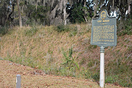
Fort Barrington, briefly renamed Fort Howe after its capture, was a mid-18th-century frontier fort. It was used and garrisoned for several conflicts, including between the British, Spanish, and Native Americans; during the American Revolution; and during the American Civil War. In the years following, much of the original site has been destroyed by river action. Despite this, it was added to the National Register of Historic Places on September 27, 1972, and is currently held as part of a hunting and fishing club. No archaeological work other than ground reconnaissance has been done.

Fort San Francisco de Pupo was an 18th-century Spanish fort on the west bank of the St. Johns River in Florida, about eighteen miles from St. Augustine, the capital of Spanish Florida. Lying on the old trail to the Spanish province of Apalachee in western Florida, Fort Pupo and its sister outpost, Fort Picolata on the opposite shore of the river, controlled all traffic on the ferry crossing. The remains of Fort Pupo are situated about three miles south of Green Cove Springs in Clay County, near the end of Bayard Point opposite Picolata. The surrounding area is a hammock of southern live oak, southern magnolia, pignut hickory and other typical trees native to the region.
The King's Carolina Rangers (KCR) was a loyalist militia regiment active during the American War of Independence. The KCR was composed of nine infantry companies, of which one was converted into a troop of dragoons in 1782. The unit primarily saw action in the South Carolina and Georgia theatres of the conflict.