Liberty County, Georgia

Last updated

Liberty County
Liberty County Court House.jpg
Map of Georgia highlighting Liberty County.svg
Location within the U.S. state of Georgia
Georgia in United States.svg
Georgia's location within the U.S.
Coordinates: 31°48′N81°28′W / 31.8°N 81.46°W / 31.8; -81.46
CountryFlag of the United States.svg United States
StateFlag of Georgia (U.S. state).svg  Georgia
FoundedFebruary 5, 1777;247 years ago (1777-02-05)
Named for Liberty
Seat Hinesville
Largest cityHinesville
Area
  Total603 sq mi (1,560 km2)
  Land490 sq mi (1,300 km2)
  Water113 sq mi (290 km2)  18.7%
Population
 (2020)
  Total65,256
  Density133/sq mi (51/km2)
Time zone UTC−5 (Eastern)
  Summer (DST) UTC−4 (EDT)
Congressional district 1st
Website www.libertycountyga.com

Liberty County is a county in the U.S. state of Georgia. As of the 2020 census, the population is 65,256. [1] The county seat is Hinesville. [2]

Contents

Liberty County is part of the Hinesville, Georgia Metropolitan Statistical Area, which is also included in the Savannah-Hinesville-Statesboro, Georgia Combined Statistical Area.

History

The area that was to become Liberty County was originally occupied by the Guale Indians. In the early 16th century, the Spanish placed a Catholic mission called Santa Catalina de Guale on today's St. Catherine's Island to minister to the Guale. During the 18th century, the Guale became part of the Muscogee confederation. In 1733, Gen. James Oglethorpe negotiated with the local Muskogean Indian tribes for this land that became part of the new colony of Georgia. Settlement of the area by European settlers was sparse until 1752. In that year, a group of Congregationalists from Dorchester, South Carolina petitioned the royal government of Georgia for grants of land in an area known as the Midway District, located between the Ogeechee and South Newport Rivers. The land was granted to them, and they moved as a community with their families and Negro slaves into the area. They immediately began clearing the swamps and marshes and establishing rice fields.

On March 15, 1758, the royal government of Georgia created Saint John's Parish, which included this area between the Ogeechee River and South Newport River. The town of Sunbury was established on June 19, 1758, on the Medway River and quickly became the 2nd busiest port in Georgia, behind Savannah.

The Congregationalists who settled the Midway District were able to establish a flourishing rice culture with the use of Negro slaves to tend to the rice fields. These Congregationalists were 2nd and 3rd generations of people born in British America and had become more independent-minded and distinct in their political views from the other citizens of the colony. In 1774, they were among the first in the colony of Georgia to join the movement for the repeal of the Intolerable Acts. In 1775, unable to persuade the rest of the colony of Georgia to join with the other 12 colonies to send a representative to the 2nd Continental Congress, they sent their own representative from Saint John's Parish, Dr. Lyman Hall.

The royal government of Georgia came to an end in January 1776 when the patriotic Georgia Council of Safety arrested the governor, James Wright and took over the government of the colony. The new government, composed of many of the leading citizens of Saint John's parish, organized a convention and established the first Constitution for the State of Georgia.

On February 5, 1777, under the new constitution, the parishes of Saint John's, Saint Andrew's and Saint James' were consolidated and named Liberty County to honor the efforts of the citizens of Saint John's parish in pursing the American ideal of liberty. [3]

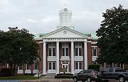
Sunbury was first designated the county seat in 1784. In 1797, the seat was transferred to Riceboro, and in 1837 it was transferred again to Hinesville. [4]

1922 lynching

On July 1, 1922, James Harvey and Joe Jordan, two African American men, were lynched by a mob of about 50 people in Liberty County during an escort by police from Jesup, Georgia to a jail in Savannah, Georgia. The event drew condemnation from both the local black community and from several prominent white citizens, with the preacher at Midway Methodist Church denouncing the acts and publishing a widely circulated letter condemning the Wayne County officials of being complicit in the murders. The incident prompted an investigation by the NAACP, and in total, 22 men were indicted, with four being convicted. [5]

Geography

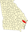
According to the U.S. Census Bureau, the county has a total area of 603 square miles (1,560 km2), of which 490 square miles (1,300 km2) is land and 113 square miles (290 km2) (18.7%) is water. [6]

The eastern and southern portion of Liberty County is located in the Ogeechee Coastal sub-basin of the Ogeechee River basin. The northern and western portion of the county is located in the Canoochee River sub-basin of the Ogeechee River basin. [7]

Major highways

Adjacent counties

Communities

Cities

Census-designated place

Unincorporated communities

Demographics

Historical population
CensusPop.Note
1790 5,355
1800 5,313−0.8%
1810 6,22817.2%
1820 6,6957.5%
1830 7,2338.0%
1840 7,2410.1%
1850 7,9269.5%
1860 8,3675.6%
1870 7,688−8.1%
1880 10,64938.5%
1890 12,88721.0%
1900 13,0931.6%
1910 12,924−1.3%
1920 12,707−1.7%
1930 8,153−35.8%
1940 8,5955.4%
1950 8,444−1.8%
1960 14,48771.6%
1970 17,56921.3%
1980 37,583113.9%
1990 52,74540.3%
2000 61,61016.8%
2010 63,4533.0%
2020 65,2562.8%
2023 (est.)69,210 [8] 6.1%
U.S. Decennial Census [9]
1790-1880 [10] 1890-1910 [11]
1920-1930 [12] 1930-1940 [13]
1940-1950 [14] 1960-1980 [15]
1980-2000 [16] 2010 [17]
Liberty County racial composition as of 2020 [18]
RaceNum.Perc.
White (non-Hispanic)24,00436.78%
Black or African American (non-Hispanic)27,30941.85%
Native American 2250.34%
Asian 1,3252.03%
Pacific Islander 4370.67%
Other/Mixed 4,1706.39%
Hispanic or Latino 7,78611.93%

As of the 2020 United States census, there were 65,256 people, 23,485 households, and 16,657 families residing in the county.

Education

Liberty County School District headquarters Liberty County Board of Education.jpg
Liberty County School District headquarters

Liberty County School District is the designated school district for grades K-12 for the county, except parts in Fort Stewart. Fort Stewart has the Department of Defense Education Activity (DoDEA) as its local school district, [19] for the elementary level. [20] Students at the secondary level on Fort Stewart attend public schools operated by county school districts. [21]

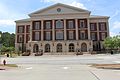
The Liberty district operates public schools, including the comprehensive high school Liberty County High School and the Bradwell Institute, as well as its educative middle schools Midway Middle School, Lewis Frasier Middle School, and Snelson-Golden Middle School.

They also provide a career academy, Liberty College & Career Academy (LCCA), for extra academics where students study for a profession they could seek out in the future.

In the media

The 2014 independent film, A Promise, was filmed in Liberty County. [22] [23]

Politics

United States presidential election results for Liberty County, Georgia [24]
Year Republican Democratic Third party
No.%No.%No.%
2020 7,95937.20%13,10461.25%3311.55%
2016 6,13437.68%9,55658.70%5893.62%
2012 5,56534.36%10,45764.57%1731.07%
2008 5,82835.54%10,47463.87%980.60%
2004 6,13147.86%6,61951.67%590.46%
2000 4,45544.68%5,34753.62%1701.70%
1996 3,04237.42%4,46254.89%6257.69%
1992 2,83235.87%3,85348.80%1,21015.33%
1988 3,10051.24%2,90648.03%440.73%
1984 3,22953.53%2,80346.47%00.00%
1980 1,50732.18%3,09966.18%771.64%
1976 97922.73%3,32877.27%00.00%
1972 2,33765.76%1,21734.24%00.00%
1968 59216.78%1,57244.55%1,36538.68%
1964 1,45839.73%2,21260.27%00.00%
1960 92936.88%1,59063.12%00.00%
1956 96752.02%89247.98%00.00%
1952 51726.31%1,44873.69%00.00%
1948 1219.98%82067.66%27122.36%
1944 12220.23%48179.77%00.00%
1940 10220.00%40779.80%10.20%
1936 4911.64%36987.65%30.71%
1932 185.84%28993.83%10.32%
1928 20350.25%20149.75%00.00%
1924 399.38%33480.29%4310.34%
1920 17536.61%30363.39%00.00%
1916 266.95%24565.51%10327.54%
1912 298.12%25170.31%7721.57%

See also

Related Research Articles

<span class="mw-page-title-main">Tattnall County, Georgia</span> County in Georgia, United States

Tattnall County is a county located in the southeast portion of the U.S. state of Georgia, located within the Magnolia Midlands, a part of the Historic South region. As of the 2020 census, the population was 22,842. The county seat is Reidsville. Tattnall County was created on December 5, 1801, from part of Montgomery County, Georgia by the Georgia General Assembly.

<span class="mw-page-title-main">McIntosh County, Georgia</span> County in Georgia, United States

McIntosh County is a county located in the U.S. state of Georgia. As of the 2020 census, the population was 10,975, a drop of 23.4 percent since the 2010 census. The county seat is Darien.

<span class="mw-page-title-main">Long County, Georgia</span> County in Georgia, United States

Long County is a county located in the U.S. state of Georgia. The county seat is Ludowici. Long County is part of the Hinesville-Fort Stewart Metropolitan Statistical Area. The constitutional amendment to create the county was proposed August 14, 1920, and ratified November 2, 1920. The county is named after Crawford Long (1815–1878), an American surgeon and pharmacist who was the first to use diethyl ether as an anaesthetic.

<span class="mw-page-title-main">Effingham County, Georgia</span> County in Georgia, United States

Effingham County is a county located in the southeastern part of the U.S. state of Georgia. As of the 2020 census, the population was 64,769. The seat is Springfield.

<span class="mw-page-title-main">Chatham County, Georgia</span> County in Georgia, United States

Chatham County is located in the U.S. state of Georgia, on the state's Atlantic coast. The county seat and largest city is Savannah. One of the original counties of Georgia, Chatham County was created February 5, 1777, and is named after William Pitt, 1st Earl of Chatham.

<span class="mw-page-title-main">Bryan County, Georgia</span> County in Georgia, United States

Bryan County is a county located in the U.S. state of Georgia. As of the 2020 census, the population was 44,738. The county seat is Pembroke.

<span class="mw-page-title-main">Bulloch County, Georgia</span> County in Georgia, United States

Bulloch County is a county located in the southeastern part of the U.S. state of Georgia. As of the 2020 census, the population was 81,099, up from 70,217 in 2010. The county seat is Statesboro. With Evans County, Bulloch forms part of the Statesboro micropolitan statistical area, a component of the Savannah–Hinesville–Statesboro combined statistical area.

<span class="mw-page-title-main">Richmond Hill, Georgia</span> City in Georgia, United States

Richmond Hill is a city in Bryan County, Georgia, United States. The population was 16,633 at the 2020 U.S. census, an increase of almost 80% from the 2010 population of 9,281. Richmond Hill is part of the Savannah metropolitan statistical area.

<span class="mw-page-title-main">Allenhurst, Georgia</span> City in Georgia, United States

Allenhurst is a city in Liberty County, Georgia, United States. It is a part of the Hinesville-Fort Stewart metropolitan statistical area. As of the 2020 census, the city had a population of 816.

<span class="mw-page-title-main">Flemington, Georgia</span> City in Georgia, United States

Flemington is a city in Liberty County, Georgia, United States. It is a part of the Hinesville-Fort Stewart metropolitan statistical area. The population was 825 in 2020.

<span class="mw-page-title-main">Fort Stewart</span> US Army post in southeast Georgia

Fort Stewart is a United States Army post in the U.S. state of Georgia. It lies primarily in Liberty and Bryan counties, but also extends into smaller portions of Evans, Long and Tattnall counties. The nearby city of Hinesville, along with Ft. Stewart and the rest of Liberty and Long Counties, comprise the Hinesville metropolitan area. Many of Fort Stewart's residents are members of the 3rd Infantry Division.

<span class="mw-page-title-main">Gumbranch, Georgia</span> City in Georgia, United States

Gumbranch, alternatively spelled Gum Branch, is a city in Liberty County, Georgia, United States. It is a part of the Hinesville-Fort Stewart metropolitan statistical area. The population was 264 at the 2010 census, and 235 in 2020.

<span class="mw-page-title-main">Hinesville, Georgia</span> City in Georgia, United States

Hinesville is a city and county seat of Liberty County, Georgia, United States, located on the Atlantic coastal plain. The population was 33,437 at the 2010 census and an estimated 33,273 in 2019. By 2020, its population was 34,891. It is the principal city of the Hinesville metropolitan area, which comprises all of Liberty County, including the Fort Stewart army installation, plus neighboring Long County.

<span class="mw-page-title-main">Midway, Georgia</span> City in Georgia, United States

Midway is a city in Liberty County, Georgia, United States. It is a part of the Hinesville-Fort Stewart metropolitan statistical area. The population was 2,141 in 2020.

<span class="mw-page-title-main">Riceboro, Georgia</span> City in the United States

Riceboro is a city in Liberty County, Georgia, United States. The population was 809 at the 2010 census. It is a part of the Hinesville-Fort Stewart metropolitan statistical area.

<span class="mw-page-title-main">Lower Coastal Plain (Georgia)</span> Subregion

Southeast Georgia's Lower Coastal Plain, often referred to as the "Coastal Empire", is a subregion that encompasses the lowest-lying areas of the Atlantic coastal plain in the state, containing barrier islands, marshes, and swampy lowlands, as well as flat plains and low terraces. It differs from Georgia's Upper Coastal Plain in that it is lower in elevation with less relief and wetter soils. The United States Environmental Protection Agency defines the Lower Coastal Plain as an ecoregion, part of the larger, interstate Southern Coastal Plain.

Sunbury is a ghost town in Liberty County, Georgia. Established in 1758, the town was mostly abandoned by the mid-1800s.

<span class="mw-page-title-main">Hinesville metropolitan area</span> Metropolitan Statistical Area in Georgia, United States

The Hinesville metropolitan area, officially the Hinesville metropolitan statistical area and previously the Hinesville–Ft. Stewart metropolitan statistical area, is defined by the U.S. Office of Management and Budget as a metropolitan statistical area consisting of two counties, Liberty and Long, in the U.S. state of Georgia. It is anchored by the city of Hinesville and encompasses all of Fort Stewart, one of the largest U.S. Army installations in the United States.

<span class="mw-page-title-main">Georgia State Route 119</span> State highway in Georgia

State Route 119 (SR 119) is an 81.2-mile-long (130.7 km) state highway that runs south-to-north in the east-central part of the U.S. state of Georgia. It runs from Riceboro to the Hinesville – Fort Stewart metropolitan area and curves to the northeast, through Pembroke and Springfield, and enters South Carolina north of Clyo, where the roadway continues as South Carolina Highway 119.

<span class="mw-page-title-main">Liberty County School District (Georgia)</span> School district in Georgia (U.S. state)

The Liberty County School District, or the Liberty County School System (LCSS), is a public school district in Liberty County, Georgia, United States, based in Hinesville. It serves the communities of Allenhurst, Flemington, Gumbranch, Hinesville, Midway, Riceboro, and Walthourville.

References

General
  1. "Census - Geography Profile: Liberty County, Georgia". United States Census Bureau . Retrieved December 27, 2022.
  2. "Find a County". National Association of Counties. Archived from the original on May 31, 2011. Retrieved June 7, 2011.
  3. Gannett, Henry (1905). The Origin of Certain Place Names in the United States. U.S. Government Printing Office. p.  186.
  4. Hellmann, Paul T. (May 13, 2013). Historical Gazetteer of the United States. Routledge. p. 233. ISBN   978-1135948597 . Retrieved November 30, 2013.
  5. Harris, J. William (2001). Deep Souths: Delta, Piedmont, and Sea Island Society in the Age of Segregation. Johns Hopkins University Press. p. 288. ISBN   978-0-8018-6563-3 via Google Books.
  6. "US Gazetteer files: 2010, 2000, and 1990". United States Census Bureau. February 12, 2011. Retrieved April 23, 2011.
  7. "Georgia Soil and Water Conservation Commission Interactive Mapping Experience". Georgia Soil and Water Conservation Commission. Retrieved November 22, 2015.
  8. "Annual Estimates of the Resident Population for Counties: April 1, 2020 to July 1, 2023". United States Census Bureau. Retrieved March 31, 2024.
  9. "Decennial Census of Population and Housing by Decades". United States Census Bureau.
  10. "1880 Census Population by Counties 1790-1800" (PDF). United States Census Bureau. 1880.
  11. "1910 Census of Population - Georgia" (PDF). United States Census Bureau. 1910.
  12. "1930 Census of Population - Georgia" (PDF). United States Census Bureau. 1930.
  13. "1940 Census of Population - Georgia" (PDF). United States Census Bureau. 1940.
  14. "1950 Census of Population - Georgia -" (PDF). United States Census Bureau. 1950.
  15. "1980 Census of Population - Number of Inhabitants - Georgia" (PDF). United States Census Bureau. 1980.
  16. "2000 Census of Population - Population and Housing Unit Counts - Georgia" (PDF). United States Census Bureau. 2000.
  17. "State & County QuickFacts". United States Census Bureau. Archived from the original on June 7, 2011. Retrieved June 23, 2014.
  18. "Explore Census Data". data.census.gov. Retrieved December 14, 2021.
  19. "2020 CENSUS - SCHOOL DISTRICT REFERENCE MAP: Liberty County, GA" (PDF). U.S. Census Bureau. Archived (PDF) from the original on July 5, 2022. Retrieved July 5, 2022. - text list - "Fort Stewart School District" refers to the DoDEA schools.
  20. "Fort Stewart Schools". Department of Defense Education Activity . Retrieved July 5, 2022.
  21. "Fort Stewart Education". Military One Source . Retrieved July 5, 2022. - This is from a .mil website.
  22. "Film company sets premieres". www.bryancountynews.com. Archived from the original on April 6, 2016. Retrieved March 26, 2016.
  23. "Georgia hears about local film industry". coastalcourier.com. Archived from the original on April 9, 2016. Retrieved March 26, 2016.
  24. Leip, David. "Dave Leip's Atlas of U.S. Presidential Elections". uselectionatlas.org. Retrieved March 21, 2018.
Specific

31°48′N81°28′W / 31.80°N 81.46°W / 31.80; -81.46