Flemington, Georgia

Last updated

Flemington, Georgia
Flemtington City Hall.jpg
Flemington City Hall
Liberty County Georgia Incorporated and Unincorporated areas Flemington Highlighted.svg
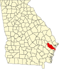
Location in Liberty County and the state of Georgia
Coordinates: 31°51′23″N81°33′40″W / 31.85639°N 81.56111°W / 31.85639; -81.56111
Country United States
State Georgia
County Liberty
Government
  MayorPaul Hawkins
Area
[1]
  Total4.77 sq mi (12.35 km2)
  Land4.77 sq mi (12.34 km2)
  Water0.00 sq mi (0.00 km2)
Elevation
20 ft (6 m)
Population
 (2020)
  Total825
  Density173.10/sq mi (66.84/km2)
Time zone UTC-5 (Eastern (EST))
  Summer (DST) UTC-4 (EDT)
ZIP code
31313
Area code 912
FIPS code 13-30088 [2]
GNIS feature ID0355840 [3]
Website cityofflemington.org

Flemington is a city in Liberty County, Georgia, United States. It is a part of the Hinesville-Fort Stewart metropolitan statistical area. The population was 825 in 2020.

Contents

History

A post office called Flemington was established in 1889, and remained in operation until 1966. [4] The community was named after William Fleming, a pioneer settler. [5] The Georgia General Assembly incorporated Flemington in 1941. [6]

Geography

Flemington is located in central Liberty County at 31°51′23″N81°33′40″W / 31.856356°N 81.561154°W / 31.856356; -81.561154 . [7] It is bordered to the west by Hinesville, the county seat. U.S. Route 84 passes through the center of Flemington, leading west into Hinesville and east 12 miles (19 km) to Interstate 95 on the east side of Midway.

According to the United States Census Bureau, Flemington has a total area of 4.7 square miles (12.3 km2), of which 0.86 acres (3,485 m2), or 0.03%, are water. [8]

Demographics

Historical population
CensusPop.Note
1950 90
1960 14965.6%
1970 26577.9%
1980 44066.0%
1990 279−36.6%
2000 36932.3%
2010 743101.4%
2020 82511.0%
U.S. Decennial Census [9]

In 2020, its population was 825.

Education

The Liberty County School District operates public schools that serve Flemington.

Related Research Articles

<span class="mw-page-title-main">Long County, Georgia</span> County in Georgia, United States

Long County is a county located in the U.S. state of Georgia. The county seat is Ludowici. Long County is part of the Hinesville-Fort Stewart Metropolitan Statistical Area. The constitutional amendment to create the county was proposed August 14, 1920, and ratified November 2, 1920. The county is named after Crawford Long (1815–1878), American surgeon and pharmacist, first to use diethyl ether as an anaesthetic.

<span class="mw-page-title-main">Liberty County, Georgia</span> County in Georgia, United States

Liberty County is a county in the U.S. state of Georgia. As of the 2020 census, the population is 65,256. The county seat is Hinesville.

<span class="mw-page-title-main">Nahunta, Georgia</span> City in Georgia, United States

Nahunta is a city and the county seat in Brantley County, Georgia, United States. It is part of the Brunswick, Georgia metropolitan statistical area. The population was 1,013 at the 2020 census. The city is an important crossroad which is intersected by U.S. Route 82 and U.S. Route 301 in its downtown area.

<span class="mw-page-title-main">Girard, Georgia</span> Town in Georgia, United States

Girard is a town in Burke County, Georgia, United States. The population was 184 in 2020. is part of the Augusta, Georgia metropolitan area.

<span class="mw-page-title-main">Sardis, Georgia</span> City in Georgia, United States

Sardis is a city in Burke County, Georgia, United States. The population is 995 in 2020. It is part of the Augusta, Georgia metropolitan area in the Central Savannah River Area (CSRA).

<span class="mw-page-title-main">Pulaski, Georgia</span> Town in Georgia, United States

Pulaski is a town in Candler County, Georgia, United States. The population was 211 in 2020.

<span class="mw-page-title-main">Bloomingdale, Georgia</span> City in Georgia, United States

Bloomingdale is a city in Chatham County, Georgia, United States. As of the 2020 census, the city had a population of 2,790. It is part of the Savannah metropolitan statistical area.

<span class="mw-page-title-main">Montgomery, Georgia</span> Place in Georgia, United States

Montgomery is an unincorporated community and census-designated place (CDP) in Chatham County, Georgia, United States. The population was 4,443 at the 2020 United States census, down slightly from 4,523 in 2010. It is a suburb of Savannah and is part of the Savannah metropolitan area.

<span class="mw-page-title-main">Ellenton, Georgia</span> Town in Georgia, United States

Ellenton is a town in Colquitt County, Georgia, United States. Its population was 281 at the 2010 census. It was incorporated in 1970 by the Georgia General Assembly. It is located at 31°10′36″N83°35′17″W.

<span class="mw-page-title-main">Springfield, Georgia</span> City in Georgia, United States

Springfield is a city in Effingham County, Georgia, United States. The population was 2,703 in 2020. The city is the county seat of Effingham County. Springfield is part of the Savannah Metropolitan Statistical Area.

<span class="mw-page-title-main">Kite, Georgia</span> City in Georgia, United States

Kite is a city in Johnson County, Georgia, United States, along the Little Ohoopee River. The population was 160 in 2020.

<span class="mw-page-title-main">Allenhurst, Georgia</span> City in Georgia, United States

Allenhurst is a city in Liberty County, Georgia, United States. It is a part of the Hinesville-Fort Stewart metropolitan statistical area. As of the 2020 census, the city had a population of 816.

<span class="mw-page-title-main">Gumbranch, Georgia</span> City in Georgia, United States

Gumbranch, alternatively spelled Gum Branch, is a city in Liberty County, Georgia, United States. It is a part of the Hinesville-Fort Stewart metropolitan statistical area. The population was 264 at the 2010 census, and 235 in 2020.

<span class="mw-page-title-main">Hinesville, Georgia</span> City in Georgia, United States

Hinesville is a city and county seat of Liberty County, Georgia, United States, located on the Atlantic coastal plain. The population was 33,437 at the 2010 census and an estimated 33,273 in 2019. By 2020, its population was 34,891. It is the principal city of the Hinesville metropolitan area, which comprises all of Liberty County, including the Fort Stewart army installation, plus neighboring Long County.

<span class="mw-page-title-main">Midway, Georgia</span> City in Georgia, United States

Midway is a city in Liberty County, Georgia, United States. It is a part of the Hinesville-Fort Stewart metropolitan statistical area. The population was 2,141 in 2020.

<span class="mw-page-title-main">Riceboro, Georgia</span> City in the United States

Riceboro is a city in Liberty County, Georgia, United States. The population was 809 at the 2010 census. It is a part of the Hinesville-Fort Stewart metropolitan statistical area.

<span class="mw-page-title-main">Ludowici, Georgia</span> American city

Ludowici is a city in Long County, Georgia, United States. The population was 1,703 at the 2010 census and an estimated 2,221 in 2018. The city is the county seat of Long County. It is a part of the Hinesville-Fort Stewart metropolitan statistical area.

<span class="mw-page-title-main">Jesup, Georgia</span> City in Georgia, United States

Jesup is a city in Wayne County, Georgia, United States. The population was 9,809 at the 2020 census. The city is the county seat of Wayne County.

<span class="mw-page-title-main">Flemington, West Virginia</span> Town in West Virginia, United States

Flemington is a town in Taylor County, West Virginia, United States. The population was 311 at the 2020 census. Flemington was incorporated in 1922 by the West Virginia Circuit Court, and named for James Fleming, an early settler in the area originally from Hampshire County.

Georgia's 1st congressional district is a congressional district in the U.S. state of Georgia. It is currently represented by Republican Buddy Carter, though the district's boundaries were redrawn following the 2010 United States census, which granted an additional congressional seat to Georgia. The first election using the new district boundaries were the 2012 congressional elections.

References

  1. "2020 U.S. Gazetteer Files". United States Census Bureau. Retrieved December 18, 2021.
  2. "U.S. Census website". United States Census Bureau . Retrieved January 31, 2008.
  3. "US Board on Geographic Names". United States Geological Survey. October 25, 2007. Retrieved January 31, 2008.
  4. "Post Offices". Jim Forte Postal History. Retrieved May 23, 2018.
  5. Krakow, Kenneth K. (1975). Georgia Place-Names: Their History and Origins (PDF). Macon, GA: Winship Press. p. 78. ISBN   0-915430-00-2.
  6. "Flemington". GeorgiaGov. Retrieved May 23, 2018.
  7. "US Gazetteer files: 2010, 2000, and 1990". United States Census Bureau. February 12, 2011. Retrieved April 23, 2011.
  8. "U.S. Gazetteer Files: 2019: Places: Georgia". U.S. Census Bureau Geography Division. Retrieved December 11, 2019.
  9. "Census of Population and Housing". Census.gov. Retrieved June 4, 2015.