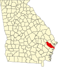
Riceboro, Georgia Last updated January 15, 2026 History The community was named for the early rice industry in the area. [ 4] [ 5] Riceboro served as the second seat of Liberty County from 1789 until 1837. [ 6]
The Georgia General Assembly first incorporated the place as the "Village of Riceborough" in 1819. [ 7]
Demographics As of the 2020 United States census , there were 615 people, 310 households, and 193 families residing in the city.
References ↑ "2020 U.S. Gazetteer Files" . United States Census Bureau. Retrieved December 18, 2021 . ↑ "U.S. Census website" . United States Census Bureau . Retrieved January 31, 2008 . ↑ "US Board on Geographic Names" . United States Geological Survey . October 25, 2007. Retrieved January 31, 2008 . ↑ Federal Writers' Project (1938). The Ocean Highway: New Brunswick, New Jersey to Jacksonville, Florida 151. ↑ Krakow, Kenneth K. (1975). Georgia Place-Names: Their History and Origins (PDF) . Macon, GA: Winship Press. p. 187. ISBN 0-915430-00-2 ↑ Hellmann, Paul T. (May 13, 2013). Historical Gazetteer of the United States 233. ISBN 978-1135948597 . Retrieved November 30, 2013 . ↑ Lamar, Lucius Quintus Cincinnatus (1821). A Compilation of the Laws of the State of Georgia 1051 . ↑ "US Gazetteer files: 2010, 2000, and 1990" . United States Census Bureau . February 12, 2011. Retrieved April 23, 2011 . ↑ "Census of Population and Housing" . Census.gov. Retrieved June 4, 2015 . ↑ "Explore Census Data" . data.census.gov . Retrieved December 14, 2021 . This page is based on this
Wikipedia article Text is available under the
CC BY-SA 4.0 license; additional terms may apply.
Images, videos and audio are available under their respective licenses.