Evans County, Georgia

Last updated

Evans County
EvansCountycourthouse2a.png
Evans County Courthouse in Claxton
EvansCountySeal.jpg
Map of Georgia highlighting Evans County.svg
Location within the U.S. state of Georgia
Georgia in United States.svg
Georgia's location within the U.S.
Coordinates: 32°10′N81°53′W / 32.16°N 81.89°W / 32.16; -81.89
CountryFlag of the United States.svg United States
StateFlag of Georgia (U.S. state).svg  Georgia
Founded1914;110 years ago (1914)
Named for Clement A. Evans
Seat Claxton
Largest cityClaxton
Area
  Total187 sq mi (480 km2)
  Land183 sq mi (470 km2)
  Water4.0 sq mi (10 km2)  2.1%
Population
 (2020)
  Total10,774
  Density59/sq mi (23/km2)
Time zone UTC−5 (Eastern)
  Summer (DST) UTC−4 (EDT)
Congressional district 12th
Website www.evanscounty.org

Evans County is a county in the southeastern portion of the U.S. state of Georgia. As of the 2020 census, the population was 10,774. [1] The county seat is Claxton. [2] A bill creating the county was passed in the Georgia General Assembly on August 11, 1914, and later, on November 3, 1914, an amendment was ratified by a vote of the people which formally created the county. Evans became part of the Statesboro micropolitan area in 2023, joining Bulloch County.

Contents

Evans County is located in an area known as the Magnolia Midlands within the Historic South region. The current Evans County Courthouse was created in 1923 and, in 1940, the people of Evans County elected their first female sheriff. Later, in the 1950s and 1960s, new growth came to the county with the building of Evans Memorial Hospital and the Claxton-Evans County Airport. In 2010, the population was 11,000; however, the 2012 Census Estimate showed a population of 10,689.

The county sits firmly within Georgia's coastal plain region and has predominantly sedimentary rock and red and yellow clays. The Canoochee River is the major body of water flowing through the county.

Manufacturing, educational, health and social services make up much of Evans County's diverse economy. Major employers in the county include Camellia Health and Rehabilitation, Claxton Poultry Company, Georgia Department of Corrections, Pinewood Christian Academy, and Valmont Newmark. The county is ranked 64 out of 71 Tier 1 counties with an 8% sales tax. Businesses in the county are 100% exempt on all classes of certain business inventory from property taxes.

History

The White Building, a three-story building used as the courthouse until 1923 FormerCourthouse.png
The White Building, a three-story building used as the courthouse until 1923

On August 11, 1914, the Georgia General Assembly proposed a constitutional amendment to create Evans County from Bulloch and Tattnall counties. Georgia voters ratified the proposed amendment by a vote of 36,689 to 9,789 [3] on November 3, 1914, which marks the official date of Evans County's creation. The county was named in honor of Clement A. Evans. Evans was a state senator from Stewart County, Georgia, a Brigadier General in the Confederate States Army, a Methodist minister, an historian and an author. [4]

The push to create Evans County came about for various reasons, most notably the desire to not have to travel so far to the court house; more office jobs; increase in businesses coming to the area, especially in regard to hotels and eating establishments and a belief that there was a minority in Reidsville, Georgia – the county seat in Tattnall County – which controlled the county. [4] Moreover, the entrance of the Savannah and Western Railroad into Tattnall County created a desire by landowners to have stations on their property; ultimately, these new stations led to the founding of the cities which would become part of Evans County: Bellville, Claxton, Daisy and Hagan. [5]

However, not everyone was for the creation of a new county. Some of the arguments against the creation of a new county included: the idea that the difficulties with distance to the courthouse were being overcome; also, the tax burden would override any benefits from new jobs. [4] Evans County was approved through the constitutional amendment process because of an earlier amendment from 1904 which limited the number of counties to 145. In order to get around this amendment, a new amendment was passed which allowed for the creation of Evans County. [6]

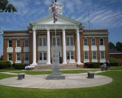
The current Evans County courthouse was completed in 1923. The courthouse is in Claxton and was designed in the neoclassical revival tradition by architect J.J. Baldwin. [4] [6] Prior to the building of the current courthouse, all of the county's business was held in the White Building, a three-story edifice built by Mr. R. King White and later bought by Mrs. Ben Daniel. Mrs. Daniel's husband, Dr. Ben Daniel, used the building as his office. [4]

The first female elected sheriff in Evans County, and in Georgia, was Mrs. Josie Mae Rogers, who was appointed after the death of the late sheriff, her father Jesse C. Durrence on June 24, 1940. Later, she was elected sheriff by the people of the county. [7] Not long after, in July 1940, Camp Stewart – which would eventually become Fort Stewart – was created after the United States government bought up several tracts of land in various counties, including Evans County. In all, it is estimated that approximately 1,500 people were displaced by the creation of the camp. [8]

The late 1950s and the 1960s were a time of growth in Evans County, especially in regards to health care and transportation. Beginning in 1958, Dr. Curtis Gordon Hames began research on the Evans County Heart Study, which was funded by the National Institutes of Health; this study would continue until 1995 and resulted in 560 published papers on heart disease, genetics, cancer and other areas. [9] In 1964, the FAA approved a site for the construction of an airport in the county, just three miles (4.8 km) northeast of Claxton. [4] [10] On December 7, 1967, after two decades of effort, Evans Memorial Hospital was opened. [4]

In November 1975, B.G. Tippins, a teacher at Claxton High School, worked with 15 students to build a Miller Lil' Rascal, a two-seat sporting biplane. This plane was the only one of its kind built. [11]

From 1980 to 1983 several buildings were placed on the National Register of Historic Places, including the courthouse and three homes.

On October 16, 2006, the Evans County Sheriff's Department was presented with seven bullet-proof vests by the Georgia Fraternal Order of Police. [12]

On June 3, 2008, Evans County commissioners unanimously passed a resolution to mark August 11 as Evans County Day. [13] Since that day there have been annual celebrations of the county's founding including the 2014 centennial celebration.

Geography

Evans County, showing the county seat, Claxton, and major roads and the major body of water, the Canoochee River EvansCountyMap.PNG
Evans County, showing the county seat, Claxton, and major roads and the major body of water, the Canoochee River

According to the U.S. Census Bureau, the county has a total area of 187 square miles (480 km2), of which 183 square miles (470 km2) is land and 4.0 square miles (10 km2) (2.1%) is water. [14] The major body of water is the Canoochee River which flows through Evans County. The Canoochee is a tributary of the Ogeechee River.

There are several ponds in Evans County. They include Cypress Pond; Dyess Pond; Beasley Pond; Bernard Smith Pond; I.W. DeLoach Ponds; Big Beasley Pond DeLoach Pond. Other bodies of water include Tippins Lake; Grice Creek; Billy Fork Creek; Thick Creek; Mill Branch; Barnard Mill; Rocky Branch; Scott Creek; Cedar Creek; and Dry Creek. [15]

The entirety of Evans County is located in the Canoochee River sub-basin of the Ogeechee River basin. [16]

Geology and terrain

Milky quartz sample QuartzUSGOV.jpg
Milky quartz sample

Geologically, Evans County lies in the coastal plain region of Georgia, an area consisting mostly of sedimentary rocks. [17] The coastal plain is divided from the Piedmont by the Fall Line, which passes through Georgia from Augusta, Georgia in the east, then southwestward to Macon, Georgia, then to Columbus, Georgia and finally westward to Montgomery, Alabama. [18]

Yet, sedimentary rocks are not the only geological features to be found in Evans County. The county is mostly covered by thin sand and red and yellow clay. [19] As in Tattnall County along the Ohoopee River, the sand in Evans County that lies along the Canoochee River is white quartz of a medium to coarse grain. [19] There is exploitable medium-grain sand covering about 50 acres of land along the railroad above Bull Creek. The pure white sand along the Canoochee could be made into bottle glass, but is expensive to recover. [19]

Flora and fauna

Stewartia pseudocamellia Stewartia pseudocamellia 01.JPG
Stewartia pseudocamellia

Evans County is home to several protected species of flora and fauna. Among the flora in the county are the Georgia plume, Sarracenia flava , Sarracenia minor , beardtongue, Stewartia , loblolly-bay and sweetbay. Others include the purple honeycomb head, large-stem morning-glory, few-flower gay-feather, pond spice, Lobelia boykinii , hummingbird flower, and other plants. Protected animals in the area include the red-cockaded woodpecker, the indigo snake, Bachman's sparrow, the spotted turtle, Say's spiketail and the southern bald eagle, among other animals. [4] [20]

Climate

Evans County is classified as a humid subtropical climate under the Köppen classification and has a mild climate, averaging 49.8 degrees in January and 82.7 degrees in July. The average annual rainfall is 48 inches and the county has a minimum altitude of 65 feet (20 m) above sea level and a maximum altitude of 228 feet (69 m) above sea level. [21] The county is 1.4 times below the U.S. average in historical area-adjusted tornado activity. From 1950 to 2004, only 2 injuries have been caused by tornadoes in the county; this occurred on March 29, 1974, when an F1 tornado hit the county, causing between $5,000 and $50,000 in damages. [15]

Monthly average daily high and low temperatures for Evans County cities
CityJanFebMarAprMayJunJulAugSepOctNovDec
Bellville [22] 61
36
66
39
73
44
79
50
86
59
91
67
94
71
92
70
87
65
80
54
71
45
63
38
Claxton [23] 61
36
66
39
73
44
79
50
86
59
91
67
94
71
92
70
87
65
80
54
71
45
63
38
Daisy [24] 61
36
66
39
73
44
79
50
86
59
91
67
94
71
92
70
87
65
80
54
71
45
63
38
Hagan [25] 61
36
66
39
73
44
79
50
86
59
91
67
94
71
92
70
87
65
80
54
71
45
63
38
Temperatures are given in °F format, with highs on top of lows

Adjacent counties

Communities

Demographics

Historical population
CensusPop.Note
1920 6,594
1930 7,1027.7%
1940 7,4014.2%
1950 6,653−10.1%
1960 6,9524.5%
1970 7,2904.9%
1980 8,42815.6%
1990 8,7243.5%
2000 10,49520.3%
2010 11,0004.8%
2020 10,774−2.1%
2023 (est.)10,754 [26] −0.2%
U.S. Decennial Census [27]
1790-1880 [28] 1890-1910 [29]
1920-1930 [30] 1930-1940 [31]
1940-1950 [32] 1960-1980 [33]
1980-2000 [34] 2010 [35]
Evans County racial composition as of 2020 [36]
RaceNum.Perc.
White (non-Hispanic)6,03856.04%
Black or African American (non-Hispanic)3,08328.62%
Native American 150.14%
Asian 780.72%
Pacific Islander 110.1%
Other/Mixed 3122.9%
Hispanic or Latino 1,23711.48%

As of the 2020 United States census, there were 10,774 people, 4,020 households, and 2,747 families residing in the county.

Economy

Agriculture and industry

Bales of hay adjacent to a pecan tree orchard outside of Claxton, Georgia in Evans County Evans County Agriculture.jpg
Bales of hay adjacent to a pecan tree orchard outside of Claxton, Georgia in Evans County

Evans County has a diverse economy, with manufacturing; educational, health and social services; retail trade; and construction providing the greatest employment in manufacturing. The Claxton-Evans County Industrial Park provides the strongest source of manufacturing, with the creation of concrete poles and galvanization of metals. Major employers in Evans County include Evans Memorial Hospital, Camellia Health and Rehabilitation, Claxton Poultry Company, Georgia Department of Corrections, Glenvue Nursing Home, JGI Incorporated Galaxy Food Center, McDonald's Restaurants, Nesmith Chevrolet Company, Pinewood Christian Academy, and Valmont Newmark. [37]

Outside of the cities, agriculture is important with corn and cotton being major crops. Other crops planted and harvested in Evans County include soybeans; wheat and vegetables; and land set aside for orchards. [15] The food industry is the most common industry for Evans Countians to work in. [15]

Local taxes

Evans County has an 8% total sales tax, including 4% state, 1% local option, 1% special purpose, and 1% educational. [38] Evans County is ranked 64 out of 71 Tier 1 counties in the state of Georgia. [39] Claxton and Evans County exempt 100% on all classes of certain business inventory from property taxes. [39]

Culture

People

U.S. Representative from Hagan, Georgia WilliamWashingtonLarsen.jpg
U.S. Representative from Hagan, Georgia

Evans County is populated by many different ethnic groups. [40] Among these groups are Whites; Blacks or African Americans; Native Americans; Asians; Pacific Islanders; and Hispanics or Latinos. Foreign born Evans Countians are predominantly Mexican, followed by Filipinos; Guatemalans; Japanese; Indians; Germans; and Indonesians. The most common ancestries in Evans County include American; English; Irish; German; Scots-Irish; French; and Italian. [15] The combination of these ancestries and ethnicities has forged Evans County's character.

Evans Countians

Evans County has had a number of notable citizens. James Kicklighter is a film director from Bellville, Georgia. [41] Joseph Kennedy was born in Claxton and went on to become the senator for the area and president pro tempore of the Georgia State Senate. Albert Parker and Ira S. Womble Sr. both made Claxton and Evans County famous through their respective companies, The Claxton Bakery and The Georgia Fruitcake Company. [42] [43] Cartha Deke DeLoach, a native Evans Countian, joined the FBI and worked alongside J. Edgar Hoover while Dr. Curtis Gordon Hames did a groundbreaking study on heart disease. [9] Two Evans County natives, Charles Gordon Edwards of Daisy, and William Washington Larsen of Hagan, went on to become United States Representatives. [44] [45]

Customs

Shriners participating in the annual Rattlesnake Roundup Parade in Claxton, Evans County, Georgia ShrinersRattlesnakeRoundup.jpg
Shriners participating in the annual Rattlesnake Roundup Parade in Claxton, Evans County, Georgia

Evans County has held an annual rattlesnake roundup the second weekend of March since 1968, with the festival growing every year since then and moving from within Claxton to just outside the city in 2001; this festival has undergone a change and is now called the Claxton Rattlesnake and Wildlife Festival. [46] [47] Another, more recent, annual event is the Cruisin' in the Country Bike Ride, began in 1995 as the Yuletide Ride. The event was changed from December to November the next year and expanded to include a 65-mile (105 km) route. Soon, the route became a complete century ride. [48]

Other events include the Martin Luther King Day parade, held every January; Christmas in Claxton, an event which occurs on the first Saturday in December and includes arts and crafts, food, and the Parade of Lights; barrel racing at the Richey Arena; and a tractor pull held on the first Saturday of each month at the Longneedle Farm Truck and Tractor Pull. [49] A Chicken Pickin' festival was held September 11, 2010. [50]

Cuisine

Skillet-baked cornbread Skillet cornbread 1.jpg
Skillet-baked cornbread

Evans County's cuisine includes a variety of different foods ranging from seafood, corn on the cob and chicken and dumplings to Brunswick stew, fried chicken and cornbread. Other well known and loved foods in the county include pecans, peaches and peanuts. [51] However, these are not the only foods enjoyed by Evans Countians. Because of the diversity within the county, the people of Evans County also frequent Mexican and Chinese restaurants.

Architecture

The George W. DeLoach House in Hagan, Georgia DeLoachHouse.jpg
The George W. DeLoach House in Hagan, Georgia

A number of buildings and homes in Evans County are on the National Register of Historic Places. In Claxton, there is the Dr. James W. Daniel House; the Evans County Courthouse; and the Mitchell J. Green Plantation. [52] In Hagan, there is the George W. DeLoach House. [52] And at Camp Oliver there is the Glisson Store (DOE). [52] Other places of interest include the Daisy Post Office and the train depot in Bellville. [53] [54]

Evans County is also home to a number of antebellum houses that were built prior to the formation of the county. Many of these homes were built in the Plantation Plain style and include the A.D. Eason House; the Thomas A. Durrence House; and the Edwards-Strickland House. [55]

Law and government

Politics

United States presidential election results for Evans County, Georgia [56]
Year Republican Democratic Third party
No.%No.%No.%
2020 2,88867.98%1,32431.17%360.85%
2016 2,40466.26%1,13031.15%942.59%
2012 2,26863.62%1,26835.57%290.81%
2008 2,46263.85%1,37435.63%200.52%
2004 2,29165.16%1,21334.50%120.34%
2000 1,84159.77%1,21739.51%220.71%
1996 1,20647.52%1,11744.01%2158.47%
1992 1,24442.03%1,23041.55%48616.42%
1988 1,70762.01%1,02337.16%230.84%
1984 1,60157.30%1,19342.70%00.00%
1980 1,09042.33%1,45656.54%291.13%
1976 74631.38%1,63168.62%00.00%
1972 1,66681.63%37518.37%00.00%
1968 54321.63%49219.60%1,47558.76%
1964 1,57266.30%79933.70%00.00%
1960 56734.66%1,06965.34%00.00%
1956 35623.61%1,15276.39%00.00%
1952 43326.13%1,22473.87%00.00%
1948 1188.42%95367.97%33123.61%
1944 11713.39%75686.50%10.11%
1940 1127.37%1,39992.04%90.59%
1936 354.54%73395.07%30.39%
1932 213.65%54895.14%71.22%
1928 19228.19%48971.81%00.00%
1924 212.54%79095.41%172.05%
1920 163.57%43296.43%00.00%
1916 347.98%33478.40%5813.62%

Government

The courthouse annex in Claxton, Evans County, Georgia CourthouseAnnex.png
The courthouse annex in Claxton, Evans County, Georgia

The county government is a constitutional body and is granted powers by the Constitution of Georgia. Evans County has a board of commissioners, sheriff, tax commissioner and clerk of court. The original top positions were held by:

Individuals currently holding Constitutional Offices are:

Board of Commissioners: The board of commissioners in Evans County is made up of six members elected by the people and led by a chairman elected by the board. [21] The board of commissioners acts as both the legislative and executive branches of government for the county and is charged with financing county programs and paying the salaries of constitutional officers. [57]

The current members of the Board of Commissioners are: [58]

Tax Commissioner: The tax commissioner receives tax returns, maintains tax records for the county, and collects and pays tax funds to the state and local government. [57]

Clerk of Court: The responsibility of the clerk of the court is to maintain court records and supervise registration of property transactions. [57]

Law enforcement and emergency services

Sheriff: The sheriff maintains the peace in the county through enforcement of the law and provide judicial security and civil services of the court [57] In Evans County, the sheriff is assisted by almost twenty employees [21]

Fire department and EMS: The Evans County fire department is located in Claxton and has a fire chief, four dispatchers, and 21 volunteers. [21] Ambulance services are provided by Evans County EMS. EMS has seven full-time employees and four part-time employees. [59]

Evans County is represented in the Georgia General Assembly by State Senator Jack Hill in Georgia Senatorial District 4 and State Representative Bill Werkheiser. The county is represented in Congress by Rick Allen of Georgia's 12th congressional district. [21]

Media

The Claxton Enterprise is a weekly newspaper located in Claxton, Georgia, United States. It primarily serves Evans County, Georgia. The Enterprise was established in 1912 with its first issue being published on December 4, 1912. The current publisher is Mitchell Peace. [4]

Evans County has one local radio station, simultaneously broadcast on both the AM and FM bands. WCLA (1470 AM and 93.7 FM) offers CBS News each hour, while programming Adult Standards music. WCLA broadcasts Claxton High School and Pinewood Christian Academy football, basketball and baseball. WCLA is the Evans County affiliate for both University of Georgia Bulldog football and basketball, as well as Atlanta Braves baseball. The station observed its 57th birthday on July 30, 2015.

Sports and recreation

Sports in Evans County include the Claxton High School athletic program and the Pinewood Christian Academy athletic program. Both schools programs include football; baseball; basketball; track and field; softball; and tennis. Claxton High School also has a golf program. Claxton's boys' track and field were Georgia High School Association champions in 1983 and the boys' basketball team were champions in 1988. [60] [61]

The county is home to a handful of public areas which are set aside for recreation. The Evans County Public Fishing Area, located in Claxton, is one such area and contains three lakes of 8, 30 and 84 acres and primitive campsites. Families can also picnic at the lake and an outdoor classroom is available for use. Parks include Bacon Ford Park and the Senior Citizens Park in Claxton. [62] Two parks in Hagan are the Maggie Mae Lewis Children's Park and the Bradley Memorial Park. [63]

Another outdoor recreational area is the Evans Heights Golf Club. The course was designed by Don Cottle Jr. in 1970 and has Bermuda grass. In total, the course is 6,514 yards. [64]

Infrastructure

Health care

Side entrance to Evans Memorial Hospital in Claxton, Evans County, Georgia EvansMemorialHospital.png
Side entrance to Evans Memorial Hospital in Claxton, Evans County, Georgia

Evans County has several medical facilities, including the Evans County Memorial Hospital; [65] the Jack Strickland Rehabilitation Wellness Center; [66] Northspring Assisted Living; [67] The Griffin House; the Camellia Health and Rehabilitation Center; The Evans County Health Department and Health and Well-Being Consultative Services. [68] There are approximately twelve doctors in the county, two dentists and two pharmacies. [68]

Education

Evans County has both public and private schools.

Public education in most of Evans County is supervised by the Evans County School District for grades K-12, except parts in Fort Stewart. Fort Stewart has the Department of Defense Education Activity (DoDEA) as its local school district, [69] for the elementary level. [70] Students at the secondary level on Fort Stewart attend public schools operated by county school districts. [71] The current[ when? ] superintendent of the public school district is Dr. Marty Waters.[ citation needed ]

All schools have been fully accredited by the Southern Association of Colleges and Schools as well as the Georgia Accrediting Commission. [72] There are currently 1,888 students and 122 teachers, a ratio of 15:1. [73] There are three public schools in Evans County: Claxton Elementary School; Claxton Middle School; and Claxton High School.

Pinewood Christian Academy is a co-educational private school in Bellville. Founded in 1970, the school has approximately 685 students and has a calendar year of 180 days with each school day lasting 7 hours.

Transportation

The Bellville train depot in Bellville Bellvilletraindepot.jpg
The Bellville train depot in Bellville

Transportation in Evans County is overseen by the Georgia Department of Transportation, a part of the executive branch of the state government. The major U.S. highways that run through Evans County are U.S. Route 25; U.S. Route 280; and U.S. Route 301. State highways running through Evans County are State Route 30; State Route 73; State Route 129; State Route 169; and State Route 292. Georgia Central Railway provides transportation for industrial customers in the county. [21]

Air travel in Evans County is provided by the Claxton-Evans County Airport. The site for the airport was approved by the FAA in 1964 and it was activated in 1971; the airport is three miles (4.8 km) northeast of Claxton, Georgia. [4] [10] It is operated by the city of Claxton. [10] It has a 5,000-foot (1,500 m) runway, hangars, pilot control lighting, and a Precision Approach Path Indicator. [74] [ failed verification ] The Claxton-Evans County Airport has an elevation of 112 ft (34 m). [10]

Major highways

RoadRoute Description
US 25.svg U.S. Route 25 Starting at the intersection of US 17/SR 25 in Brunswick, US 25 goes northwest to Jesup then northeast to Ludowici. It then stays at a general north route through the cities of Statesboro, Millen, Waynesboro and finally Augusta, where it crosses the Savannah River into South Carolina. The overall majority of the route is 4-lane.
US 280.svg U.S. Route 280 US 280 begins in Georgia at the state's border with Alabama in Columbus. There it is paired with State Route 520 and U.S. Route 27. It maintains this designation as it passes through Fort Benning. US 280 continues east, where it passes through Plains and becomes cosigned State Route 30 in Americus. It maintains this designation until the route's terminus in Blichton.
US 301.svg U.S. Route 301 US 301 uses SR 4/SR 15 from Florida to Folkston, SR 23 from Folkston to Glennville, and SR 73 from Glennville to South Carolina. US 1/US 23/SR 4/SR 15/SR 121 split to the northwest at a junction north of Folkston, leaving only US 301 and SR 23 to head north across US 82/SR 520 at Nahunta to Jesup. There US 84 and SR 38 continue northeast, while US 25/US 301/SR 23 turn northwest with SR 57.
Georgia 30.svg State Route 30 US 280/SR 30 meet the southern terminus of SR 56 (Shepards Bridge Road) before curving to the northeast. Almost immediately after the end of the curve is the northern terminus SR 147 (Tattnall Street). About 1,000 feet (300 m) later is an intersection with SR 23/SR 57/SR 121 (Main Street). In Bellville, is an intersection with SR 169 (Smith Street). At North Ralph Street, SR 129 joins the concurrency. At South River Street, SR 129 departs from the concurrency to the south. In Daisy, they meet the northern terminus of former SR 250 (now known as Ellerbee Avenue).
Georgia 73.svg State Route 73 SR 23 and SR 57 split off to the northwest at Glennville. SR 73 begins there, taking US 25 and US 301 north from Glennville across US 280/SR 30 at Claxton and I-16/SR 404 to Statesboro.
Georgia 129.svg State Route 129 State Route 129 (SR 129) is a 20.0-mile-long (32.2 km) state highway that runs southeast-to-northwest through portions of Evans, Tattnall, and Candler counties in the east-central part of the U.S. state of Georgia. It connects the towns of Claxton and Metter.
Georgia 169.svg State Route 169 State Route 169 (SR 169) is a 55.4-mile-long (89.2 km) state highway that runs south-to-north through portions of Wayne, Appling, Tattnall, and Evans counties in the southeastern part of the U.S. state of Georgia.
Georgia 292.svg State Route 292 East of Lyons Georgia State Route 292 intersects with SR 86. Just past SR 86, the route crosses the Ohoopee River, where it enters Tattnall County. Farther to the southeast, in the city of Collins, is an intersection with SR 23/SR 57/SR 121. The route continues east through Manassas and enters the city of Bellville. There, it intersects SR 169. Just east of Bellville, SR 292 meets its eastern terminus, an intersection with US 280/SR 30.

Energy use and production

Evans County's electricity generation and consumption are provided through a variety of means. Natural gas is also available in large quantities. Evans Countians consumes 269,420 gallons of water a day out of a plant capacity of 3,720,000 gallons a day. There is an elevated storage capacity of 700,000 gallons. [74] [ failed verification ] The energy produced and consumed is available through the Claxton-Evans County Industrial Park. [75]

See also

Related Research Articles

<span class="mw-page-title-main">Middlesex County, Massachusetts</span> County in Massachusetts, United States

Middlesex County is located in the Commonwealth of Massachusetts, in the United States. As of the 2020 census, the population was 1,632,002, making it the most populous county in both Massachusetts and New England and the 22nd most populous county in the United States. Middlesex County is one of two U.S. counties to be amongst the top 25 counties with the highest household income and the 25 most populated counties. It is included in the Census Bureau's Boston–Cambridge–Newton, MA–NH Metropolitan Statistical Area. As part of the 2020 United States census, the Commonwealth's mean center of population for that year was geo-centered in Middlesex County, in the town of Natick.

<span class="mw-page-title-main">Allen County, Indiana</span> County in Indiana, United States

Allen County is a county in the U.S. state of Indiana. As of the 2020 Census, the population was 385,410, making it the third-most populous county in Indiana. The county seat and largest city is Fort Wayne, the second largest city in Indiana.

<span class="mw-page-title-main">Toombs County, Georgia</span> County in Georgia, United States

Toombs County is a county located in the east central portion of the U.S. state of Georgia. As of the 2020 census, the population was 27,030. The county seat is Lyons and the largest city is Vidalia. The county was created on August 18, 1905.

<span class="mw-page-title-main">Tattnall County, Georgia</span> County in Georgia, United States

Tattnall County is a county located in the southeast portion of the U.S. state of Georgia, located within the Magnolia Midlands, a part of the Historic South region. As of the 2020 census, the population was 22,842. The county seat is Reidsville. Tattnall County was created on December 5, 1801, from part of Montgomery County, Georgia by the Georgia General Assembly.

<span class="mw-page-title-main">Long County, Georgia</span> County in Georgia, United States

Long County is a county located in the U.S. state of Georgia. The county seat is Ludowici. Long County is part of the Hinesville-Fort Stewart Metropolitan Statistical Area. The constitutional amendment to create the county was proposed August 14, 1920, and ratified November 2, 1920. The county is named after Crawford Long (1815–1878), an American surgeon and pharmacist who was the first to use diethyl ether as an anaesthetic.

<span class="mw-page-title-main">Liberty County, Georgia</span> County in Georgia, United States

Liberty County is a county in the U.S. state of Georgia. As of the 2020 census, the population is 65,256. The county seat is Hinesville.

<span class="mw-page-title-main">Emanuel County, Georgia</span> County in Georgia, United States

Emanuel County is a county located in the magnolia midlands portion of the U.S. state of Georgia. As of the 2020 census, the population was 22,768. The county seat is Swainsboro.

<span class="mw-page-title-main">Dodge County, Georgia</span> County in Georgia, United States

Dodge County is a county located in the central portion of the U.S. state of Georgia. As of 2020, the population was 19,925. The county seat is Eastman. Dodge County lies in the Historic South and Black Belt region of Georgia, an area that was devoted to cotton production in the antebellum years. It has significant historic buildings and plantations, has a substantial African-American population, and shows cultural aspects of the South.

<span class="mw-page-title-main">Candler County, Georgia</span> County in Georgia, United States

Candler County is a county located in the southeastern part of the U.S. state of Georgia. As of the 2020 census, the population was 10,981. The county seat is Metter. The county was founded in 1914 and named for Allen D. Candler, the 56th governor of Georgia.

<span class="mw-page-title-main">Butts County, Georgia</span> County in Georgia, United States

Butts County is a county located in the central part of the U.S. state of Georgia. As of the 2020 census, the population was 25,434, up from 23,655 in 2010. The county seat is Jackson. The county was created on December 24, 1825.

<span class="mw-page-title-main">Bryan County, Georgia</span> County in Georgia, United States

Bryan County is a county located in the U.S. state of Georgia. As of the 2020 census, the population was 44,738. The county seat is Pembroke.

<span class="mw-page-title-main">Bellville, Georgia</span> City in Georgia, United States

Bellville is a city in Evans County, Georgia, United States. As of the 2020 census, the city had a population of 127. It is the hometown of film director James Kicklighter.

<span class="mw-page-title-main">Claxton, Georgia</span> City in Georgia, United States

Claxton is a city in Evans County, Georgia, United States. The population was 2,602 in 2020. It is the county seat of Evans County.

<span class="mw-page-title-main">Hinesville, Georgia</span> City in Georgia, United States

Hinesville is a city and county seat of Liberty County, Georgia, United States, located on the Atlantic coastal plain. The population was 33,437 at the 2010 census and an estimated 33,273 in 2019. By 2020, its population was 34,891. It is the principal city of the Hinesville metropolitan area, which comprises all of Liberty County, including the Fort Stewart army installation, plus neighboring Long County.

The Evans County School District is a school district based in Evans County, Georgia, United States. The superintendent is Dr. Marty Waters.

<span class="mw-page-title-main">Tattnall County School District</span> School district in Georgia (U.S. state)

The Tattnall County School District is a public school district in Tattnall County, Georgia, United States, based in Reidsville. It serves the communities of Cobbtown, Collins, Glennville, Manassas, and Reidsville.

<span class="mw-page-title-main">Geography of Evans County, Georgia</span>

The geography of Evans County describes a county in the state of Georgia in the Southeastern United States in North America. According to the 2010 census, the county has a total area of 182.85 square miles (473.6 km2), of which 178.65 square miles (462.7 km2) is land and 4.2 square miles (11 km2) is water. The major body of water is the Canoochee River, which flows through Evans County.

<span class="mw-page-title-main">Culture of Evans County, Georgia</span> Overview of the culture of Evans County, Georgia (USA)

The Culture of Evans County, Georgia is a subculture of the state of Georgia. The most common ancestries in Evans County are American; English; Irish; German; Scots-Irish; French; and Italian. The county has many customs, among them an annual Rattlesnake and Wildlife Festival and a century ride. Evans County's cuisine including seafood, corn on the cob and Brunswick stew, as well as Mexican and Chinese food.

<span class="mw-page-title-main">Georgia State Route 169</span> State highway in Georgia, United States

State Route 169 (SR 169) is a 55.4-mile-long (89.2 km) state highway that runs south-to-north through portions of Wayne, Appling, Tattnall, and Evans counties in the southeastern part of the U.S. state of Georgia.

<span class="mw-page-title-main">Georgia State Route 129</span> State highway in Georgia, United States

State Route 129 (SR 129) is a 20.0-mile-long (32.2 km) state highway that travels southeast-to-northwest through portions of Evans, Tattnall, and Candler counties in the east-central part of the U.S. state of Georgia. It connects the towns of Claxton and Metter.

References

General
  1. "Census - Geography Profile: Evans County, Georgia". United States Census Bureau . Retrieved December 27, 2022.
  2. "Find a County". National Association of Counties. Archived from the original on May 31, 2011. Retrieved June 7, 2011.
  3. Public Affairs Information Service Bulletin, Accessed August 30, 2008
  4. 1 2 3 4 5 6 7 8 9 10 Simmons, Dorothy (1999). A History of Evans County, Georgia. The Evans County Historical Society.
  5. The Tattnall County Heritage Committee (2013). Tattnall County Georgia 1801–1812: The Heritage of Tattnall County. The Tattnall County Heritage Committee.
  6. 1 2 "Evans County Courthouse" . Retrieved June 18, 2009.
  7. "Vanishing Georgia, Georgia Archives, University System of Georgia". Archived from the original on December 13, 2013. Retrieved December 9, 2013.
  8. "New Georgia Encyclopedia: Fort Stewart". Archived from the original on June 7, 2011. Retrieved June 18, 2009.
  9. 1 2 "Heart study pioneer, Dr. Curtis G. Hames dies". Archived from the original on May 29, 2010. Retrieved 2009-06-21.
  10. 1 2 3 4 "AirNav.com" . Retrieved June 29, 2009.
  11. Taylor, Michael J. H. (1989). Jane's Encyclopedia of Aviation. London: Studio Editions. p. 31.
  12. "Georgia Fraternal Order of Police". Archived from the original on November 26, 2011. Retrieved January 4, 2012.
  13. Cory Cunningham (June 12, 2008). "Evans County Day set for August". The Claxton Enterprise.
  14. "US Gazetteer files: 2010, 2000, and 1990". United States Census Bureau. February 12, 2011. Retrieved April 23, 2011.
  15. 1 2 3 4 5 "Evans County, Georgia detailed profile" . Retrieved June 21, 2009.
  16. "Georgia Soil and Water Conservation Commission Interactive Mapping Experience". Georgia Soil and Water Conservation Commission. Archived from the original on October 3, 2018. Retrieved November 22, 2015.
  17. "A Tapestry of Time and Terrain: The Coastal Plain, a USGS mapping project". Archived from the original on May 6, 2009. Retrieved June 20, 2009.
  18. "The Geology of Georgia". Archived from the original on February 5, 2007. Retrieved June 20, 2009.
  19. 1 2 3 Bulletin – Geological survey. 1921. Retrieved August 7, 2009.
  20. "Locations of Special Concern Animals, Plants and Natural Communities in Evans County, Georgia". Archived from the original on July 20, 2011. Retrieved July 21, 2009.
  21. 1 2 3 4 5 6 "Fingertip Facts" (PDF). Archived from the original (PDF) on July 8, 2011. Retrieved June 20, 2009.
  22. "Average Weather for Bellville, GA – Temperature and Precipitation" . Retrieved November 29, 2013.
  23. "Average Weather for Claxton, GA – Temperature and Precipitation". Archived from the original on December 3, 2013. Retrieved November 29, 2013.
  24. "Average Weather for Daisy, GA – Temperature and Precipitation". Archived from the original on December 3, 2013. Retrieved November 29, 2013.
  25. "Average Weather for Hagan, GA – Temperature and Precipitation" . Retrieved November 29, 2013.
  26. "Annual Estimates of the Resident Population for Counties: April 1, 2020 to July 1, 2023". United States Census Bureau. Retrieved March 31, 2024.
  27. "Decennial Census of Population and Housing by Decades". United States Census Bureau.
  28. "1880 Census Population by Counties 1790-1800" (PDF). United States Census Bureau. 1880.
  29. "1910 Census of Population - Georgia" (PDF). United States Census Bureau. 1910.
  30. "1930 Census of Population - Georgia" (PDF). United States Census Bureau. 1930.
  31. "1940 Census of Population - Georgia" (PDF). United States Census Bureau. 1940.
  32. "1950 Census of Population - Georgia -" (PDF). United States Census Bureau. 1950.
  33. "1980 Census of Population - Number of Inhabitants - Georgia" (PDF). United States Census Bureau. 1980.
  34. "2000 Census of Population - Population and Housing Unit Counts - Georgia" (PDF). United States Census Bureau. 2000.
  35. "State & County QuickFacts". United States Census Bureau. Archived from the original on June 7, 2011. Retrieved June 22, 2014.
  36. "Explore Census Data". data.census.gov. Retrieved December 18, 2021.
  37. "Evans County at a Glance". Archived from the original on April 14, 2013. Retrieved January 21, 2012.
  38. "Georgia Sales Tax Rates: Evans County" . Retrieved July 30, 2016.
  39. 1 2 "Job Tax Credit Rankings 2010" (PDF). Retrieved January 14, 2010.[ permanent dead link ]
  40. "U.S. Census website". United States Census Bureau . Retrieved May 14, 2011.
  41. "New documentary examines first transgender singer in opera history to perform in a principal role".
  42. "A Special Tribute". Archived from the original on July 6, 2009. Retrieved June 21, 2009.
  43. "The History of Georgia FruitCake Co". Archived from the original on April 10, 2009. Retrieved June 22, 2009.
  44. "EDWARDS, Charles Gordon (1878–1931)" . Retrieved June 22, 2009.
  45. "LARSEN, William Washington, (1871–1938)" . Retrieved June 22, 2009.
  46. "Roundup History". Archived from the original on February 2, 2009. Retrieved June 20, 2009.
  47. Special to the Enterprise (January 25, 2012). "Rattlesnake event undergoes transformation". The Claxton Enterprise.
  48. "Event History". Archived from the original on July 8, 2011. Retrieved June 20, 2009.
  49. "Community". Archived from the original on January 29, 2009. Retrieved June 20, 2009.
  50. Hackle, Al (July 7, 2012). "Chicken to take center stage at new fall event". The Claxton Enterprise. Claxton, Georgia: Mitchell Peace.
  51. "Foodways: Overview". Archived from the original on August 14, 2009. Retrieved May 12, 2007.
  52. 1 2 3 "National Register of Historic Places: Georgia – Evans County". Archived from the original on November 19, 2009. Retrieved June 21, 2009.
  53. "The Claxton Enterprise: Daisy, Georgia" . Retrieved June 21, 2009.
  54. "The Claxton Enterprise: Bellville, Georgia" . Retrieved June 21, 2009.
  55. Johnson, Phariss (2001). Houses of Heart Pine: A Survey of the Antebellum Architecture of Evans County, Georgia. The Evans County Historical Society.
  56. Leip, David. "Dave Leip's Atlas of U.S. Presidential Elections". uselectionatlas.org. Retrieved March 19, 2018.
  57. 1 2 3 4 "New Georgia Encyclopedia: Georgia's County Governments". Archived from the original on October 12, 2012. Retrieved June 20, 2009.
  58. "Evans County Board of Commissioners". Archived from the original on November 6, 2014. Retrieved November 6, 2014.
  59. "Evans County Emergency Medical Service". Archived from the original on July 27, 2009. Retrieved June 23, 2009.
  60. "GSHA Boys' Track Champions" . Retrieved June 21, 2009.
  61. "GSHA Boys' Basketball Champions" . Retrieved June 21, 2009.
  62. "The Claxton Enterprise: Claxton, Georgia" . Retrieved June 20, 2009.
  63. "The Claxton Enterprise: Hagan, Georgia" . Retrieved June 20, 2009.
  64. "Evans Heights Golf Club in Claxton, Georgia". Archived from the original on June 5, 2008. Retrieved July 24, 2009.
  65. "Evans Memorial Hospital" . Retrieved June 21, 2009.
  66. "Jack Strickland Rehabilitation Wellness Center". Archived from the original on January 19, 2009. Retrieved June 21, 2009.
  67. "Northspring Assisted Living". Archived from the original on January 14, 2011. Retrieved June 21, 2009.
  68. 1 2 "Health Care". Archived from the original on December 14, 2010. Retrieved June 20, 2009.
  69. "2020 CENSUS - SCHOOL DISTRICT REFERENCE MAP: Evans County, GA" (PDF). U.S. Census Bureau. Archived (PDF) from the original on July 5, 2022. Retrieved July 5, 2022. - text list - "Fort Stewart School District" refers to the DoDEA schools.
  70. "Fort Stewart Schools". Department of Defense Education Activity . Retrieved July 5, 2022.
  71. "Fort Stewart Education". Military One Source . Retrieved July 5, 2022. - This is from a .mil website.
  72. "Georgia Accrediting Commission" (PDF). Archived from the original (PDF) on November 7, 2004. Retrieved May 19, 2007.
  73. "Public School Review" . Retrieved May 20, 2007.
  74. 1 2 "Evans County, GA". Archived from the original on February 21, 2013. Retrieved June 29, 2009.
  75. "Economic Development". Archived from the original on January 7, 2010. Retrieved January 14, 2010.
Specific

32°10′N81°53′W / 32.16°N 81.89°W / 32.16; -81.89