Baldwin is a city in Banks and Habersham counties in the U.S. state of Georgia. As of the 2010 census, the city had a population of 3,279, up from 2,425 at the 2000 census.

Dahlonega is the county seat of Lumpkin County, Georgia, United States. As of the 2010 census, the city had a population of 5,242, and in 2018 the population was estimated to be 6,884.

The Tallulah River is a 47.7-mile-long (76.8 km) river in Georgia and North Carolina. It begins in Clay County, North Carolina, near Standing Indian Mountain in the Southern Nantahala Wilderness and flows south into Georgia, crossing the state line into Towns County. The river travels through Rabun County and ends in Habersham County. It cuts through the Tallulah Dome rock formation to form the Tallulah Gorge and its several waterfalls. The Tallulah River intersects with the Chattooga River to form the Tugaloo River at Lake Tugalo in Habersham County. It joins South Carolina's Seneca River at Lake Hartwell to form the Savannah River, which flows southeastward into the Atlantic Ocean.
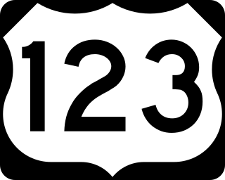
U.S. Route 123 is a spur of US 23 in the U.S. states of Georgia and South Carolina. The U.S. Highway runs 75.12 miles (120.89 km) from US 23, US 441, SR 15 and SR 365 near Clarkesville, Georgia, north and east to Interstate 385 Business in Greenville, South Carolina. US 123 parallels I-85 to the north as it connects the Northeast Georgia cities of Clarkesville and Toccoa with the western Upstate South Carolina communities of Westminster, Seneca, Clemson, Easley, and Greenville.

The Chattooga River is the main tributary of the Tugaloo River.

Area codes 706 and 762 are telephone area codes in the North American Numbering Plan (NANP) for the northern and west central parts of Georgia, but excluding metropolitan Atlanta.
The Chestatee River is a 32.76-mile-long (52.72 km) river in the Appalachian Mountains of northern Georgia, USA.

The Chattahoochee–Oconee National Forest in northern Georgia comprises two United States National Forests, the Oconee National Forest in eastern Georgia and the Chattahoochee National Forest located in the North Georgia Mountains. The Chattahoochee National Forest is composed of an eastern and western forest. The western forest contains Johns Mountain, Little Sand Mountain, and Taylor Ridge (Georgia). The combined total area of the Chattahoochee–Oconee National Forest is 867,265 acres (3,510 km2), of which the Chattahoochee National Forest comprises 751,069 acres (3,039 km2) and the Oconee National Forest comprises 116,196 acres (470 km2). The county with the largest portion of the eastern forest is Rabun County, Georgia, which has 148,684 acres (601.7 km2) within its boundaries.
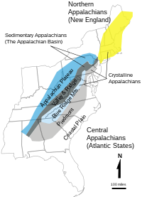
North Georgia is the northern hilly/mountainous region in the U.S. state of Georgia. At the time of the arrival of settlers from Europe, it was inhabited largely by the Cherokee. The counties of north Georgia were often scenes of important events in the history of Georgia. It was the site of many American Civil War battles, including the Battle of Lookout Mountain and the Battle of Chickamauga, leading up to the Atlanta Campaign. Today, particularly in the northeast portion of the region, tourism sustains the local economy.

WGTA is a television station licensed to Toccoa, Georgia, United States, serving much of the northeastern portion of the state. The station is owned by Marquee Broadcasting, and has studios on Big A Road in Toccoa; its transmitter is located northwest of Black Rock Mountain outside of Toccoa in unincorporated Stephens County.

The Episcopal Diocese of Atlanta is the diocese of the Episcopal Church in the United States of America, with jurisdiction over middle and north Georgia. It is in Province IV of the Episcopal Church and its cathedral, the Cathedral of St. Philip, is in Atlanta, as are the diocesan offices.
Pine Mountain is an unincorporated community located in eastern Rabun County, Georgia, United States, at an elevation of 1611 feet. It is one of only two Georgia communities located north of South Carolina, due to a quirk of geography: the Chattooga River is the primary tributary of the Savannah River and Tugalo River specified in the 1787 Treaty of Beaufort, but runs perpendicular to them.
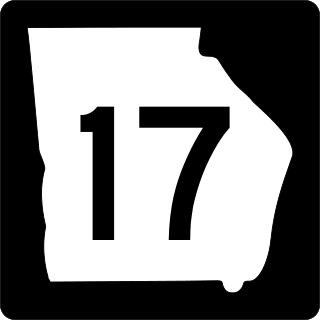
State Route 17 (SR 17) is a 300-mile-long (480 km) state highway that travels northwest–southeast in the east-central and northeastern parts of the U.S. state of Georgia. The highway connects the Savannah metro area to the North Carolina state line, northwest of Hiawassee and runs roughly parallel to the South Carolina state line.

State Route 60 (SR 60) is a 90.1-mile-long (145.0 km) state highway that travels southeast-to-northwest through portions of Jackson, Hall, Lumpkin, Union, and Fannin counties in the north-central part of the U.S. state of Georgia. The highway connects the Braselton area with McCaysville at the Tennessee state line, via Gainesville and Dahlonega.
North Georgia Technical College (NGTC) is a public technical college in Clarkesville, Georgia, with additional campuses in Toccoa and Blairsville. It is part of the Technical College System of Georgia. The college serves Habersham, Stephens, Union, Fannin, White, Rabun, Towns, and Franklin counties.

State Route 115 (SR 115) is a 32.3-mile-long (52.0 km) state highway that runs west-to-east in the northeastern part of the U.S. state of Georgia. It travels through portions of Lumpkin, White, and Habersham counties.

The Piedmont Atlantic megaregion is a neologism created by the Regional Plan Association for an area of the Southeastern United States that contains parts of the states of Alabama, Georgia, Tennessee, South Carolina, and North Carolina. The region includes the Atlanta, Birmingham, Charlotte, Memphis, Nashville, Research Triangle (Raleigh–Durham), Upstate South Carolina (Greenville–Spartanburg–Anderson), and Greensboro–Winston-Salem–High Point metropolitan areas. The megaregion generally follows the Interstate 85/20 corridor. According to Georgia Tech, the Piedmont Atlantic represents over 12 percent of the total United States population and covers over 243,000 square miles (630,000 km2) of land.
The Northeast Georgia Regional Library System (NEGRLS) is a collection of seven public libraries in the counties of Habersham, White, Rabun, and Stephens, Georgia, United States.