Brasstown Bald

Last updated
Brasstown Bald
Enotah
Brasstown Bald from Hogpen Gap view, Oct 2018.jpg
October 2018: Brasstown Bald is the highest mountain in the background
Highest point
Elevation 4,784 ft (1,458 m) [1]
Prominence 2,108 ft (643 m) [1]
Listing U.S. state high point 25th
Mountains of Georgia
Coordinates 34°52′27″N83°48′38″W / 34.874199°N 83.810652°W / 34.874199; -83.810652 Coordinates: 34°52′27″N83°48′38″W / 34.874199°N 83.810652°W / 34.874199; -83.810652 [2]
Geography
USA Georgia relief location map.svg
Red triangle with thick white border.svg
Brasstown Bald
Parent range Blue Ridge Mountains
Topo map USGS Jacks Gap
Climbing
Easiest route Drive or hike

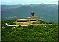
Brasstown Bald is the highest point in the U.S. state of Georgia. It is located in the northeastern part of the state in the Blue Ridge Mountains on the border between Towns and Union counties south of the city of Hiawassee. The mountain is known to the native Cherokee people as Enotah. [2]

Contents

Description

The name in English is derived from a mistaken translation of the term for the nearby Cherokee village of Brasstown, located along the upper Brasstown Creek (named in English from the same error) feeding the Hiawassee River. [3]

Immediately north of the mountain and across the state line with North Carolina are other places named by English settlers: Brasstown, a community in the Brasstown township of Clay County, North Carolina.

Brasstown Bald encompasses Towns and Union counties with the county line intersecting the peak. The mountain is part of the Blue Ridge Mountains (part of the Appalachian Mountains) and within the borders of the Blue Ridge Ranger District of the Chattahoochee National Forest. The mountain consists mostly of soapstone and dunite.

On a clear day it is possible to see the tallest buildings of Atlanta, some 85 miles away from the summit. The U.S. Forest Service has webcams atop the observation tower and a RAWS weather station further down the mountain. The public can drive to a parking lot 0.5 miles (0.8 km) from the top via Georgia State Route 180 Spur and then continue to the summit via a shuttle bus or a short hike on a paved trail. [4]

History

Brasstown Bald Historical Marker #2 Brasstown Bald Historical Marker -2.JPG
Brasstown Bald Historical Marker #2

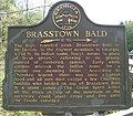
According to the two Georgia historical markers, the area surrounding Brasstown Bald was settled by the Cherokee people. English-speaking settlers derived the word "Brasstown" from a translation error of the Cherokee word for its village place. Settlers confused the word Itse'yĭ (meaning "New Green Place" or "Place of Fresh Green"), which the Cherokee used for their village, with Ûňtsaiyĭ ("brass"), and referred to the settlement as Brasstown. The Cherokee gave the locative name, Itse'yĭ, to several distinct areas in their territory, including an area nearby in what is considered present-day North Carolina.

According to Cherokee legend about Itse'yĭ, a great flood swept over the land. All the people died except a few Cherokee families who sought refuge in a giant canoe. The canoe ran aground at the summit of a forested mountain (now known as Enotah). As there was no wild game for the people to hunt and no place for them to plant crops, the Great Spirit killed all the trees on the top of the mountain so that the surviving people could plant crops. They continued planting and lived from their crops until the water subsided.[ citation needed ]

Other transliterated spellings of the Cherokee name for the mountain include Echia,Echoee,Etchowee, and Enotah.[ citation needed ]

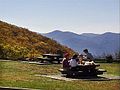
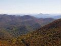
The term "Bald" is common terminology in the southern Appalachians describing mountaintops that have 360-degree unobstructed views.

Former Georgia Supreme Court Judge Thomas S. Candler is memorialized with a stone monument at Brasstown Bald. It was erected in 1971 three months before he died in recognition of his efforts to support getting more visitors to the mountain and establishing a visitor center there for them. [5]

Distances to summit

From the northeast, starting at the intersection of Owl Creek Road and the concurrent Georgia 17 and Georgia 75 near Mountain Scene, the climb is 13.5 miles (21.7 km) long, gaining 828 feet (252 m).

From the southeast, starting at the intersection of Georgia 180 and Georgia 17/75 near Sooky Gap, the climb is 13.1 miles (21.1 km) long, gaining 790 feet (241 m), an average of 6.0% grade.

From the west, starting at the intersection of Georgia 180 and Georgia 348 near Choestoe, the climb is 14.9 miles (24.0 km), gaining 856 feet (261 m), an average of 5.7% grade.

From the intersection of Route 180 and Route 180 Spur at Jacks Gap the climb is 4.9 miles (7.9 km) at an average gradient of 11.2%, (height gain: 551 feet (168 m)).

An additional route to the summit is the Wagon Train Trail, starting at Young Harris College. The trail is traditionally hiked by graduating students and their families on the evening before graduation; a vespers service is held at the summit.

Tour de Georgia

In the 2005 through 2008 editions of the Tour de Georgia, a long-distance bicycle race, Brasstown Bald was the site of an hors categorie "King of the Mountains stage" finish.

Appearances in the Tour de Georgia
YearStageStartWinner
2008 6 Blairsville Kanstantsin Sivtsov
2007 5 Dalton Levi Leipheimer
2006 5 Blairsville Tom Danielson
2005 5 Gainesville Tom Danielson
2004 6 Athens Cesar Grajales

Broadcasting

NOAA Weather Radio station KXI22 transmits from atop the mountain, simulcasting with KXI75 from Blue Ridge, Georgia. The programming originates from NWSFO Peachtree City.

Georgia Public Broadcasting had or has construction permits from the Federal Communications Commission (FCC) for two low-power broadcast translator stations at the summit. The digital TV station on channel 12 (W25FP-D, licensed December 2009) is the direct replacement for analog TV station W04BJ in nearby Young Harris, and also covers for W50AB in nearby Hiawassee (both to the north). New station WBTB FM 90.3 will transmit at just 97 watts, equivalent to several hundred watts because of the height above average terrain of over 700 meters, or more than 2,300 feet. Both stations will have Young Harris as the city of license.[ citation needed ]

Images

See also

Related Research Articles

<span class="mw-page-title-main">Towns County, Georgia</span> County in Georgia, United States

Towns County is a county located in the northeastern part of the U.S. state of Georgia. As of the 2020 census, the population was 12,493. Its county seat is Hiawassee. The county was created on March 6, 1856, and named for United States lawyer, legislator, and politician George W. Towns.

<span class="mw-page-title-main">Blairsville, Georgia</span> City in Georgia, United States

Blairsville is a city and the county seat of Union County, on the northern border of Georgia, United States. It was founded near the Nottely River, which was dammed in 1942 as part of the Tennessee Valley Authority project, forming Lake Nottely. As of the 2020 census, the city had a population of 616.

<span class="mw-page-title-main">Springer Mountain</span> Mountain in northern Georgia known as the southern terminus of the Appalachian Trail

Springer Mountain is a mountain located in the Chattahoochee National Forest on the border of Fannin and Gilmer counties. Located in the Blue Ridge Mountains in northern Georgia, the mountain has an elevation of about 3,782 feet (1,153 m). Springer Mountain serves as the southern terminus for the Appalachian and Benton MacKaye trails.

<span class="mw-page-title-main">Chattahoochee–Oconee National Forest</span> United States national forest in Gainesville, Georgia, USA

The Chattahoochee–Oconee National Forest in northern Georgia comprises two United States National Forests, the Oconee National Forest in eastern Georgia and the Chattahoochee National Forest located in the North Georgia Mountains. The Chattahoochee National Forest is composed of an eastern and western forest. The western forest contains Johns Mountain, Little Sand Mountain, and Taylor Ridge (Georgia). The combined total area of the Chattahoochee–Oconee National Forest is 866,468 acres (3,506 km2), of which the Chattahoochee National Forest comprises 750,145 acres (3,036 km2) and the Oconee National Forest comprises 116,232 acres (470 km2). The county with the largest portion of the eastern forest is Rabun County, Georgia, which has 148,684 acres (601.7 km2) within its boundaries.

<span class="mw-page-title-main">North Georgia</span> Geographic region of the U.S. state of Georgia

North Georgia is the northern hilly/mountainous region in the U.S. state of Georgia. At the time of the arrival of settlers from Europe, it was inhabited largely by the Cherokee. The counties of north Georgia were often scenes of important events in the history of Georgia. It was the site of many American Civil War battles, including the Battle of Lookout Mountain and the Battle of Chickamauga, leading up to the Atlanta Campaign. Today, particularly in the northeast portion of the region, tourism sustains the local economy.

<span class="mw-page-title-main">Blood Mountain</span> Mountain in Georgia, United States

Blood Mountain is the highest peak on the Georgia section of the Appalachian Trail and the sixth-tallest mountain in Georgia, with an elevation of 4,458 feet (1,359 m). It is located on the border of Lumpkin County with Union County and is within the boundaries of the Chattahoochee National Forest and the Blood Mountain Wilderness. There are several waterfalls, hiking trails and other recreational areas in the vicinity.

<span class="mw-page-title-main">Nantahala National Forest</span> National forest in North Carolina, US

The Nantahala National Forest (/ˌnæntəˈheɪlə/), is the largest of the four national forests in North Carolina, lying in the mountains and valleys of western North Carolina. The Nantahala is the second wettest region in the country, after the Pacific Northwest. Due to its environmental importance and historical ties with the Cherokee, the forest was officially established on January 29, 1920, by President Woodrow Wilson. The word "Nantahala" is a Cherokee derived, meaning "Land of the Noonday Sun." In some spots, the sun reaches the floors of the deep gorges of the forest only when it is high overhead at midday. This was part of the homeland of the historic Cherokee and their indigenous ancestors, who have occupied the region for thousands of years.

<span class="mw-page-title-main">Dick's Knob</span> Mountain in United States of America

Dick's Knob or Dicks Knob, with an elevation of 4,620 feet (1,408 m), is the third-highest peak in the State of Georgia if using a 200 ft. prominence rule. It is located in Rabun County, Georgia within the Southern Nantahala Wilderness and is the second-highest mountain in the county.

<span class="mw-page-title-main">Hightower Bald</span>

Hightower Bald, with an elevation of 4,568 feet (1,392 m) is the fourth-highest peak in the US state of Georgia. It is located in Towns County, Georgia at the North Carolina state line and is within the boundaries of the Southern Nantahala Wilderness of the Chattahoochee National Forest.

<span class="mw-page-title-main">Standing Indian Mountain</span>

Standing Indian Mountain, elevation 5,499 feet (1,676 m), is part of the North Carolina portion of the Southern Nantahala Wilderness within the boundaries of the Nantahala National Forest. The mountain lies along the Appalachian Trail and is the highest point along the Nantahala River.

<span class="mw-page-title-main">Rich Mountain (Georgia)</span> Mountain in the U.S. state of Georgia

Rich Mountain, elevation 4,040 feet (1,230 m), is the highest point in the Rich Mountain Wilderness of the Chattahoochee National Forest in Gilmer County, Georgia. It is the second-highest peak in Gilmer County; only Big Bald Mountain is taller, with its summit at 4,081 feet (1,244 m).

<span class="mw-page-title-main">Big Bald Mountain</span>

Big Bald Mountain is the highest peak in Gilmer County, Georgia, U.S. and is in the Rich Mountain Wilderness, which is administered as a component of the Chattahoochee National Forest.

<span class="mw-page-title-main">Georgia State Route 180</span>

State Route 180 (SR 180) is a 26.0-mile-long (41.8 km) state highway in the northeastern part of the U.S. state of Georgia. Its routing is located within portions of Union and Towns counties.

Rocky Knob is a name used to describe eight different mountain peaks located in the North Georgia mountains that are scattered among four different Georgia counties.

<span class="mw-page-title-main">Jacks Knob Trail</span>

Jacks Knob Trail is a hiking trail that has been designated as a National Recreation Trail in Georgia, US. The trail is 4.5 miles (7.2 km) long and is located in the Chattahoochee National Forest in the Brasstown Ranger District. The trail is managed by the U.S. Forest Service.

Warne ( "worn") is an unincorporated community in Brasstown Township, Clay County, North Carolina, United States. In 2010, Clay County was the fourth least populated county in North Carolina, inhabited by approximately 10,587 people. The region has added considerably to its population, a 20.6% increase since 2000. Warne is closer to the capitals of five other states than to Raleigh, the capital of North Carolina.

<span class="mw-page-title-main">Southern Highroads Trail</span>

The Southern Highroads Trail is a 364-mile-long (586 km) loop of scenic and historic highways in the Southeastern United States. The driving trail traverses 14 counties, four states, and four national forests, providing sightseers and passersby an array of culinary, hotel, shopping, and recreational options along the way.

<span class="mw-page-title-main">Brasstown, North Carolina</span> Unincorporated community in North Carolina, United States

Brasstown is an unincorporated community located mostly within Clay County, North Carolina, United States, though roughly one third of Brasstown is within the adjacent Cherokee County.

Brasstown is an extinct Cherokee village in Towns County, in the U.S. state of Georgia. The exact location of Brasstown is unknown to the GNIS. It was situated about 8 miles (13 km) southwest of present-day Hiawassee on the upper part of Brasstown Creek.

References

  1. 1 2 "Brasstown Bald, Georgia". Peakbagger.com. Retrieved 2012-11-08.
  2. 1 2 "Brasstown Bald". Geographic Names Information System . United States Geological Survey, United States Department of the Interior . Retrieved 2012-11-08.
  3. Krakow, Kenneth K. (1975). Georgia Place-Names: Their History and Origins (PDF). Macon, GA: Winship Press. p. 24. ISBN   0-915430-00-2.
  4. "Chattahoochee-Oconee National Forest - Brasstown Bald Visitor Information Center". Fs.usda.gov. Retrieved 2022-09-16.
  5. T.S. Candler Bio Info/State of GA

Commons-logo.svg Media related to Brasstown Bald at Wikimedia Commons