
The Samoan Islands are an archipelago covering 3,030 km2 (1,170 sq mi) in the central South Pacific, forming part of Polynesia and of the wider region of Oceania. Administratively, the archipelago comprises all of the Independent State of Samoa and most of American Samoa. The land masses of the two Samoan jurisdictions are separated by 64 km (40 mi) of ocean at their closest points.
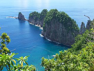
The National Park of American Samoa is a national park in the United States territory of American Samoa, distributed across four islands: Tutuila, Ofu, Olosega, and Ta‘ū. The park preserves and protects coral reefs, tropical rainforests, fruit bats, and the Samoan culture. Popular activities include hiking and snorkeling. Of the park's 8,257 acres (3,341 ha), 2,500 acres (1,000 ha) is coral reefs and ocean. The park is the only American National Park Service system unit south of the equator.

Taʻū is the largest inhabited island in the Manuʻa Islands and the easternmost volcanic island of the Samoan Islands. Taʻū is part of American Samoa. In the early 19th century, the island was sometimes called Opoun.
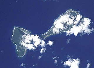
Ofu and Olosega are parts of a volcanic doublet in the Manuʻa Islands, which is a part of American Samoa in the Samoan Islands. These twin islands, formed from shield volcanoes, have a combined length of 6 km and a combined area of 12 square kilometers. Together, they have a population of about 500 people. Geographically, the islands are volcanic remnants separated by the narrow, 137-meter-wide (449-foot)) Āsaga Strait, composed of shallow-water coral reef. Before 1970, people crossed between the two islands by waiting until low tide and then wading across the shallow water of the strait. Since 1970, there has been a bridge over the strait, providing a single-lane road that connects the two islands.

The Manuʻa Islands, or the Manuʻa tele, in the Samoan Islands, consists of three main islands: Taʻū, Ofu and Olosega. The latter two are separated only by the shallow, 137-meter-wide Āsaga Strait, and are now connected by a bridge over the strait. The islands are located some 110 kilometers east of Tutuila and are a part of American Samoa, an unincorporated territory of the United States. Their combined area is 56 square kilometers, and they have a total population of 1,400. Taʻu is the largest of these islands, with an area of 44 km2 (17 sq mi), and it has the highest point of the Manuʻa, at 931 meters. Politically, the islands form the Manuʻa District, one of the three administrative divisions of American Samoa.
Utulei or ʻUtulei is a village in Maoputasi County, in the Eastern District of Tutuila, the main island of American Samoa. Utulei is traditionally considered to be a section of Fagatogo village, the legislative capital of American Samoa, and is located on the southwest edge of Pago Pago Harbor. Utulei is the site of many local landmarks: The A. P. Lutali Executive Office Building, which is next to the Feleti Barstow Library; paved roads that wind up to a former cablecar terminal on Solo Hill; the governor's mansion, which sits on Mauga o Alii, overlooking the entrance to Goat's Island, and the lieutenant governor's residence directly downhill from it; the Lee Auditorium, built in 1962; American Samoa's television studios, known as the Michael J. Kirwan Educational Television Center; and the Rainmaker Hotel. Utulei Terminal offers views of Rainmaker Mountain.

American Samoa is administratively divided into three districts and two unorganized atolls. The districts are subdivided into 15 counties, which are composed of 76 villages.
Fitiuta Airport is a public airport located in Fiti‘uta, a village on the island of Ta‘ū in American Samoa, an unincorporated territory of the United States. Fitiuta Airport replaced Tau Airport, which was officially deactivated after the construction and activation of Fitiuta Airport in 1990. The Fitiuta airport is owned by the Government of American Samoa.

The following outline is provided as an overview of and topical guide to American Samoa:
American Samoa is an unincorporated territory of the United States located in the South Pacific Ocean, southeast of the island country of Samoa. Centered on 14.3°S 170.7°W, it is east of the International Date Line and the Wallis and Futuna Islands, west of the Cook Islands, north of Tonga, and some 500 kilometers (310 mi) south of Tokelau. American Samoa is the southernmost territory of the United States and one of two U.S. territories south of the Equator, along with the uninhabited Jarvis Island.

Āfono is a village on the northeast coast of Tutuila Island, American Samoa. One of the island's more populous villages, it is located on the edge of Afono Bay, at the eastern edge of the National Park of American Samoa. It is connected by Highway 6 to Vatia, which lies along the coast to the northwest, and to Aua, on the edge of Pago Pago Harbor to the south via a winding stretch of highway which crosses the spine of the island.

A'oloau is a village in the west of Tutuila Island, American Samoa. It is located inland, 5 miles (8 km) southwest of Pago Pago. It is also known as A’oloaufou, which means "new A’olou". An abandoned area in town by A'oloau Bay is known as A'oloautuai, which means Old A’oloau’. A'oloau's nickname is Nuu Puaolele which means the Fog Village.

Tui Manu'a Matelita, born Margaret Young, and also known as Makelita, Matelika or Lika was the Tui Manu'a of Manu'a, a group of islands in the eastern part of the Samoan Islands, from 1891 to 1895. During her tenure, she served largely a ceremonial role at her residence on Ta'ū where she received British writer Robert Louis Stevenson. Matelita never married because she would not marry any of the eligible native chieftains and no other men were regarded as having the proper rank to marry her. She died of illness in 1895, although later reports claimed she died by a more violent means. She was buried in the Tui Manu'a Graves Monument.
The Tui Manu'a Graves Monument is a funerary marker and grave site on the island Ta'u, the largest island of the Manu'a group in American Samoa. It is located northwest of the junction of Ta'u Village and Ta'u Island Roads on the west side of the island. It consists of a stone platform, about 3 feet (0.91 m) in height, that is roughly rectangular in shape with a projection at one end. Three graves are marked by square sections of smoothed stones, while a fourth is marked by a marble column. A possible fifth grave, unmarked, is in the projection. It is the burial site of several tu'i, or kings, of Manu'a, including Tui Manu'a Matelita and Tui Manu'a Elisala, the Samoan leader whose signature granted the United States hegemony over the islands.
Vailoatai is a village in southwestern Tutuila, the main island of American Samoa. It is located on the eastern end of Leone Bay. The village is known for its beautiful malae, nested along the island's rugged southern coast and lined by the fale tali mālō of its village chiefs.

Matafao Peak is a mountain in American Samoa, on the island of Tutuila. With an elevation of 653 meters (2,142 ft), it is the highest peak on Tutuila Island. The mountain, like Rainmaker Mountain across Pago Pago Harbor, is a remnant of a volcanic plug and is part of the volcanic origins of the island. The mountain can be hiked from the high point of the Pago Pago-to-Fagasa Road. It is designated a National Natural Landmark above the 492-foot level, an area known as Matafao Peak National Natural Landmark.

Vatia is a village on Tutuila Island in American Samoa. It is a north shore village located on Vatia Bay. The road to Vatia, American Samoa Highway 006, is the only road going through National Park of American Samoa. Vatia is a scenic community at the foot of Pola Ridge and surrounded by the national park. It is only reached by Route 6 which traverses the national park before reaching Vatia. There was once a hiking trail over Maugaloa Ridge from Leloaloa, but since the completion of Route 6, this trail is now overgrown. It is home to a beach, and panoramic views of jungle-covered peaks surround the village on all sides. Vatia is the center of the Tutuila-section of National Park of American Samoa. It is located in Vaifanua County.
Fagasā is a village in the Eastern District of Tutuila Island in American Samoa. The village lies by Fagasa Bay, on the north shore of the island. Its name is Samoan and translates to “Forbidden Bay.” The village borders the Tutuila-section of National Park of American Samoa. The trailhead to Mount ‘Alava is located near the village by Fagasa Pass.
