Mount Greylock

Last updated

Mount Greylock
Greylock & Hopper.JPG
Mt. Greylock seen from the West
Highest point
Elevation 3,489 ft (1,063 m)  NAVD 88 [1]
Prominence 2,463 ft (751 m) [2]
Listing U.S. state high point 31st
New England Fifty Finest 17th
Coordinates 42°38′13″N73°09′57″W / 42.63704°N 73.16593°W / 42.63704; -73.16593 [1]
Geography
Parent range Taconic Mountains [3] [4] [5]
Geology
Age of rock Ordovician, Taconic orogeny
Mountain type thrust fault
Climbing
Easiest route Cheshire Harbor Trail [6]
Mount Greylock Summit Historic District
LocationJct. of Notch, Rockwell, and Summit Rds., Adams, Massachusetts
Area1,200 acres (490 ha) [7]
Built1830
ArchitectMaginnis and Walsh; Vance, Joseph MacArthur, et al.
Architectural styleBungalow/Craftsman, Classical Revival
NRHP reference No. 98000349 [8]
Added to NRHPApril 20, 1998

Mount Greylock in northwest Massachusetts is the highest point in the state at 3,489 feet (1,063 meters). The peak played a role in early American literature, [9] [10] [11] and is part of the Taconic Mountains, which are geologically distinct from the nearby Berkshires and Green Mountains. Expansive views and a small area of sub-alpine forest characterize its upper reaches. A seasonal automobile road crosses the summit area near three structures from the 1930s which together constitute a small, "National Historic District." Various hiking paths including the Appalachian Trail traverse the area, which is part of the larger Mount Greylock State Reservation. [12]

Contents

Geography

A view of the Mount Greylock Range from South Williamstown (from the west). The Hopper, a cirque, is centered below the summit. Mount Greylock Massive.JPG
A view of the Mount Greylock Range from South Williamstown (from the west). The Hopper, a cirque, is centered below the summit.

Mount Greylock is part of an 11-mile-long (18 km) massif called the "Greylock Range" near the Hoosic River, which hooks around the range on the east and north. Various summits include Saddle Ball Mountain, along with Mount Fitch and others.

Standing about 2,000 feet (610 meters) above the local Hoosac Valley, Mount Greylock's summit is in Adams, Massachusetts. Other parts of the range extend into five neighboring towns. Sight lines of up to 72 mi (116 km) are possible from Greylock. [13] [14]

The Greylock Range is part of the Taconic Mountains, which are separated here from the Berkshires and Green Mountains by the nearby Hoosac Valley. [15]

The massif is mostly within the Hudson River watershed via the Hoosac River, although a small part near Lanesborough is within the Housatonic River watershed. [16] [17]

The eastern slopes of Greylock are noted for the Thuderbolt ski trail (see below), landslide scars above the city of Adams and "Greylock Glen," a state-sponsored development plan. The western slopes include "The Hopper," said to be a glacial cirque. The mountain's north and southern reaches are noted for the presence of an auto road as well as hiking trails.

Climate

Climate data for Mount Greylock 42.6355 N, 73.1653 W, Elevation: 3,127 ft (953 m) (1991–2020 normals)
MonthJanFebMarAprMayJunJulAugSepOctNovDecYear
Mean daily maximum °F (°C)26.2
(−3.2)
28.4
(−2.0)
35.6
(2.0)
48.3
(9.1)
59.9
(15.5)
68.0
(20.0)
72.4
(22.4)
71.0
(21.7)
65.2
(18.4)
53.2
(11.8)
40.8
(4.9)
31.3
(−0.4)
50.0
(10.0)
Daily mean °F (°C)17.9
(−7.8)
19.3
(−7.1)
26.5
(−3.1)
38.2
(3.4)
49.5
(9.7)
58.1
(14.5)
62.3
(16.8)
61.0
(16.1)
55.2
(12.9)
44.1
(6.7)
32.9
(0.5)
23.8
(−4.6)
40.7
(4.8)
Mean daily minimum °F (°C)9.5
(−12.5)
10.3
(−12.1)
17.4
(−8.1)
28.0
(−2.2)
39.1
(3.9)
48.1
(8.9)
52.3
(11.3)
50.9
(10.5)
45.2
(7.3)
34.9
(1.6)
24.9
(−3.9)
16.4
(−8.7)
31.4
(−0.3)
Average precipitation inches (mm)4.22
(107)
3.67
(93)
4.30
(109)
4.86
(123)
5.10
(130)
5.76
(146)
5.56
(141)
5.39
(137)
6.10
(155)
5.71
(145)
4.58
(116)
5.23
(133)
60.48
(1,535)
Source: PRISM Climate Group [18]

Forests and birds

Red spruce on Mount Greylock Picea rubens UGA.jpg
Red spruce on Mount Greylock
New England aster on Mount Greylock New England Aster on Mount Greylock.jpg
New England aster on Mount Greylock

Northern hardwood forest characterize lower and mid-elevations, while upper slopes are covered with balsam fir and red spruce as well as American mountain ash. About 555 acres (225 hectares) of old growth forest have been inventoried within the Greylock Range, including tree specimens up to 350 years old. On the western slope was a 120-foot-tall (37 m) red spruce. [19] [20]

There are purported records of 132 bird species on the mountain. These include the blackpoll warbler and Bicknell's thrush which breed exclusively in boreal forest, with limited opportunities elsewhere in Massachusetts. [21]

Geology

Mount Greylock is part of the much larger Taconic Allochthon, a structure that migrated to its present position from 25 miles to the east. [22] The rocks moved via thrust faulting, a tectonic process by which older rock is thrust up and above younger rock. [23]

More narrowly, the local massif is mostly "Greylock Schist," a term used by geologists starting in 1891 and much more recently, although the age of these rocks had been uncertain into the 1960s. [24] This Ordovician-era schist is about 1,000 to 2,000 feet thick on Greylock and "consists of muscovite (sericite), chlorite, and quartz schist." It lies above a formation called "Bellows Pipe Limestone." [25] This younger, underlying layer has been quarried on the lower slopes of the mountain.

In the most recent ("Pleistocene") ice age, glaciation rounded the mountain, carving out the U-shaped, dead-end valleys that form "The Hopper" on Greylock's western slope, and leaving glacial erratics such as "Balanced Rock" on Greylock in Lanesborough. [26] [13] [27] The Laurentide Ice Sheet had covered the region up to a depth of one kilometer (or 3,281 feet). In melting, it formed Lake Bascom in the upper Hoosic Valley. [28] The remains of lake beaches are evident (to a few geologists) at several places on the lowest slopes of Greylock.

Geologists used Surface Exposure Dating in 2018 to measure the rate of Pleistocene de-glaciation of the region. This method offered data in support of a more rapid melting rate in New England compared with earlier estimates. [29]

Nomenclature

"Mount Greylock" as the mountain's present name "probably originated with Williams College Professor Albert Hopkins" (1807–1872) or another local professor of the same era, according to one 1988 source. [30] The peak's namesake, Gray Lock [31] (c. 1670–1750) was an Abenaki tribal figure from near Westfield, Mass., known for raiding English outposts near the Connecticut River [32] and not historically associated with the mountain.

The 18th century English may have called the peak "Grand Hoosuc," although Timothy Dwight IV referred to it as "Saddle Mountain" in his travel memoir concerning the late 18th century. [33]

In the early 19th century it was called "Saddleback Mountain" because of its appearance seen from the south. [31] According to a 1838 journal entry (posthumously published 1868), Nathaniel Hawthorne overheard a local resident calling it "Graylock." Hawthorne added that Saddleback "is a more usual name for it." Yet elsewhere Hawthorne simply called it Graylock, attributing this name to the mountain's frequent appearance in winter frost. [34]

Nonetheless, as of 1841, Edward Hitchcock's authoritative "Final Report" on state geology called the entire massif "Saddle Mountain" and "the highest point of the summit" according to Hitchcock was called "Graylock." . [35]

Historic District

Three structures contribute to the 1930s "Mount Greylock Summit Historic District," which is part of the National Register of Historic Places as of 1998. [8] These are the Bascom Lodge and the Thunderbolt Ski Shelter, both designed by Pittsfield architect, Joseph McArthur Vance, and the War Memorial Tower designed by Boston-based Maginnis & Walsh. Together, their cultural significance as period architecture was cited in the register

Bascom Lodge

Bascom Lodge and Saddle Ball Mountain looking southwest from the War Memorial Tower Bascom Lodge atop Mount Greylock.JPG
Bascom Lodge and Saddle Ball Mountain looking southwest from the War Memorial Tower

Bascom Lodge was built between 1932 and 1938 using native materials of Greylock schist and red spruce [36] and characterized by the rustic design of period park structures. The Greylock Commission sought a more substantial shelter to replace an earlier summit house (built c.1902; destroyed by fire in 1929). The initial west wing was constructed in 1932 by Jules Emil Deloye Jr. The main-central and east wings were completed later 1935–38 by the Civilian Conservation Corps, supervised by Deloye. The lodge was named in honor of John Bascom, a Greylock Reservation Commissioner and local professor (d. 1911). [37]

For the winter of 1937–38, the Greylock Commission hired Harrison L. Lasuer to spend the season living in the lodge "to act as host to skiers and other Winter enthusiasts who scale the mountain.". [38] The building was equipped for that winter with "steam heat, electricity and a telephone," according to a New York City newspaper. A ski race later that season attracted 7,000 spectators, mainly near the base of the mountain (see ref. below).

Today, Bascom Lodge is run (in warmer months only) by a service company under a concession-type lease from the state. [39] Among other earlier arrangements, the Appalachian Mountain Club managed the lodge for 16 summers ending in 2000. [40]

Thunderbolt Ski Shelter, Trail and Race Series

Snowboarders ascending near the Needles Eye on the Thunderbolt, January 2015 Thunderbolt Skiers.jpg
Snowboarders ascending near the Needles Eye on the Thunderbolt, January 2015

The Thunderbolt Ski Shelter, also designed by Joseph McArthur Vance, was built in 1940 by the Civilian Conservation Corps as a warming hut for skiers using the Thunderbolt Trail. [41]

Like the nearby lodge, the shelter is rustic in design and built of local stone and wood beams; the interior has four wooden benches built into a large four-hearth fireplace in the center. It is several hundred feet north of the summit tower.

Although Bascomb Lodge reportedly employed a resident winter innkeeper in 1938 (see above citation), the 1940 introduction of this nearby shelter may have made a seasonal shut-down of the lodge less inconvenient during large-scale ski events of the era.

This trail was designed with help from numerous ski groups and cut by the CCC in 1934. Major competitive ski races were held on here almost annually from 1935 until 1948. [42] Among the largest was a 1938 event attended by 7,000 spectators, who watched Fritz Dehmel of Nazi Germany set a course record of 2 minutes and 25 seconds. [43] [44] Famed U.S. skier Dick Durrance placed fifth in this race, which pre-dated the Thunderbolt shelter. Dehmel's record for the 1.4-mile course held until 1948. The trail is similar in steepness to the longer Sherburne Trail of Pinkham Notch, N.H. [45]

The Thunderbolt ski race was revived in 2010 and in certain subsequent years, [46] but a lack of snow disrupted or relocated some of the events to commercial ski areas with artificial snow. In 2018, the race group said it would switch to "less frequent intervals" for the event, instead of annually. [47] [48] Separately, a 1990s landslide area on the eastern face of Greylock that is unrelated to the Thunderbolt trail was reportedly skied in 2005 [49]

Veterans War Memorial Tower

Veterans War Memorial Tower Mount Greylock war memorial.jpg
Veterans War Memorial Tower

The Veterans War Memorial Tower was approved by the state legislature in 1930, supported by local lawmakers and Governor Frank G. Allen. It was completed two years later at a cost of $200,000 by contractors J.G. Roy & Son of Springfield. [50] [51] An estimated 1,500 people attended the 1933 dedication by Governor Joseph B. Ely, an event broadcast nationally over NBC radio. [52]

The 93-foot-tall (28 m) shaft with eight observation windows, was designed to display classic austerity. It includes Art Deco details, some by John Bizzozero of Quincy, whose work also appears on the Vermont Capitol building. Inside at ground level is a domed chamber intended to store tablets and war relics. [53]

Although area legislators and residents wanted local stone, the tower's granite facing was obtained in Quincy. The tower bears various inscriptions including, "they were faithful even unto death." One of the inscriptions inside the monument is, "Of those immortal dead who live again in the minds made better by their presence", which is a line from a poem by George Eliot. The translucent globe of light on top, originally illuminated by twelve 1,500 watt lights (now six), is said to be visible at night for 70 mi (110 km). It creates a light-pollution problem for the summit area all night long.

Renovations due to persistent water infiltration, August 2016 Scaffolding on Mt. Greylock's War Memorial.jpg
Renovations due to persistent water infiltration, August 2016

The Veterans War Memorial Tower was closed for four years beginning in 2013 because of water infiltration, which caused structural damage from freezing. A $2.6 million restoration project was awarded to Allegrone Construction of Pittsfield that began in August 2015. [54]

Broadcast tower

Although not as part of the Historic District, one radio and one television station transmit from a broadcast tower below the summit on the west side: WAMC (90.3 Albany, New York); and W38DL (38 Adams, Massachusetts) (repeater of WNYT-TV). A NOAA Weather Radio station (WWF-48, 162.525 MHz) broadcasts from a different tower on the mountain. [55] The Northern Berkshire Amateur Radio Club runs several amateur radio repeaters on the mountain under the callsign K1FFK. [56]

History

In American Literature

Herman Melville Herman Melville 1860.jpg
Herman Melville

By the mid-19th century, improved transportation into the region attracted many visitors to Greylock. Among them were writers and artists inspired by the mountain scene: Nathaniel Hawthorne, William Cullen Bryant, Oliver Wendell Holmes, Herman Melville, and Henry David Thoreau. [57]

In the summer of 1838, Hawthorne had visited North Adams, Massachusetts, and climbed Mount Greylock several times. His experiences there, specifically a walk he took at midnight where he saw a burning lime kiln, inspired his story, originally titled "The Unpardonable Sin". [58] Hawthorne had not written tales since 1844 when he wrote "Ethan Brand" in the winter of 1848–1849. [59]

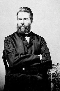
Melville is said to have taken part of his inspiration for Moby-Dick from the view of the mountain from his house Arrowhead in Pittsfield, since its snow-covered profile reminded him of a great white sperm whale's back breaking the ocean's surface. [60] Melville dedicated his next novel, Pierre , to "Greylock's Most Excellent Majesty", calling the mountain "my own ... sovereign lord and king". In August 1851 Melville and a few friends, including the young poet Sarah Morewood, camped for a night on Greylock's summit. [61] Thoreau summited and spent a night in July 1844. His account of this event in A Week on the Concord and Merrimack Rivers described his approach up what is today the Bellows Pipe Trail. Scholars contend that this Greylock experience transformed him, affirming his ability to do these excursions on his own, following his brother John's death; and served as a prelude to his experiment of rugged individualism at Walden Pond the following year in 1845. [62]

Yale University president Timothy Dwight IV climbed the mountain in 1799 Timothy Dwight IV.jpg
Yale University president Timothy Dwight IV climbed the mountain in 1799

Timothy Dwight IV, a once-famed poet and preacher, and president of Yale College, along with Williams College President Ebenezer Fitch, climbed Greylock in 1799, probably over a rough route cut by a local farmer Jeremiah Wilbur. Dwight's travel memoir describes the mountain: "During a great part of the year, it is either embosomed or capped by clouds, and indicates to the surrounding inhabitants the changes of weather with not a little exactness." [63]

Management and development history

Williams College students in 1830 directed by college President Edward Dorr Griffin improved and further cut a trail from the end of the Hopper Road to the summit. This is the current Hopper Trail, traditionally climbed by students once a year. [64]

In May 1831 a wooden meteorological observatory, "Griffin's Tower", was built on the summit by students. Nine years later, it was replaced by a more substantial 60-foot (18 m) wooden tower, from which Donati's Comet was photographed in 1858. In 1863 the Alpine Club, was founded in Williamstown by Professor Albert Hopkins. The club frequently camped on the mountain and certain members later helped found the Appalachian Mountain Club and the American Alpine Club. [65]

By the late 19th century, clearcutting had stripped most of Greylock's forest for wood products including aper and charcoal. Along with this came forest fires and landslides. The Greylock Park Association (GPA) was formed in 1885 and shares were sold locally with plans to make money by attracting tourists. [66] [67] The company purchased 400 acres (160 ha) on the summit and made repairs to the Notch Road. The GPA charged a 25-cent toll for the carriage road and a 10-cent fee to ascend the iron observation tower (built 1889). [57] Together, these fees are equivalent to $11.40 in present-day dollars. [68]

But 12 years later, with the GPA's business future in question because of debt, local legislators proposed acquiring the company and forming Mount Greylock State Reservation. This was approved in 1898 along with plans to add to the original land (to ultimately total 12,500-acre (5,100 ha). The Berkshire County government was to maintain the reservation. Other early State Reservation properties were similarly operated by local county governments. [69]

The 20th century

The first automobiles to the summit, via the Notch Road from the north, were a pair of steam-powered "Locomobiles' in 1902; a gasoline-powered car followed in 1904. [70] In 1907, Berkshire County Commission opened a new road from the south to the summit, [71] augmenting the existing northerly "Notch Road." The county subsequently attended to building hiking paths, and by 1913 had completed 17 trails. The Appalachian Trail route across the mountain was opened in 1929, and the entire Massachusetts section was mostly complete by 1931.

The Massachusetts (Veterans) War Memorial Tower on the summit was completed in 1932. [72] During nine years ending in 1941 the Civilian Conservation Corps (CCC) worked on the mountain mostly through its 107th Company, MA camp SP-7.

The entrance to Rockwell Road, which extends from Lanesborough to the summit of Mount Greylock in Adams Lanesborough - Rockwell Road Sign.JPG
The entrance to Rockwell Road, which extends from Lanesborough to the summit of Mount Greylock in Adams

CCC work included improvements to the road system (gravel surfaced), Adirondack lean-to shelters, the Thunderbolt Ski Shelter and its related trail, along with constructing much of Bascom Lodge. [42]

Starting in 1954, the Greylock Tramway Authority was formed to build an aerial tramway on the mountain. [73] After the authority announced plans for a ski resort in 1964, a local conservation group called the Mount Greylock Protective Association led a campaign to shift the Reservation to state management from Berkshire County. This succeeded in 1966 and helped to block the resort. [73] [74] [75]

State parks

The 12,500-acre (5,100 ha) Mount Greylock State Reservation is managed and operated by the Massachusetts Department of Conservation and Recreation. [12]

Mount Greylock State Reservation (Greylock summit on the far right) Mount Greylock State Reservation.jpg
Mount Greylock State Reservation (Greylock summit on the far right)

Mount Greylock has about 70 miles of hiking paths including an 11.5 mile section of the Appalachian National Scenic Trail. Primitive camping for backpackers is permitted at several sites. The staffed visitors center in Lanesborough is open year-round (1.5 miles off Route 7). [19]

The Greylock Glen, site of a former proposed tramway/ski/resort development from 1953 to 1977, is a 1,063-acre (430-hectare) park in Adams, adjoining Mount Greylock State Reservation. It was acquired by the state in 1985 for joint public-private development. [76]

2019-09-22 09 51 30 360-degree stitched panorama from the top of the Veterans War Memorial Tower on the summit of Mount Greylock in Adams, Berkshire County, Massachusetts.jpg
Stitched 360-degree panorama from the Veterans War Memorial Tower on top of Mount Greylock

See also

Related Research Articles

<span class="mw-page-title-main">Taconic Mountains</span> Appalachian Mountain range in the United States

The Taconic Mountains are a 150-mile-long sub-range of the Appalachian Mountains lying on the eastern border of New York State and adjacent New England. The range, which played a role in the history of geological science, is separated from the Berkshires and Green Mountains to the east by a series of valleys, principally those of the Housatonic River, Battenkill River and Otter Creek. The Taconics' highest point is Mount Equinox in Vermont at 3,840 feet (1,170 m); among many other summits are Dorset Mountain, Mount Greylock and Mount Everett.

<span class="mw-page-title-main">Mount Tom (Massachusetts)</span> Mountain near Holyoke, Massachusetts, U.S.

Mount Tom, 1,202 feet (366 m), is a steep, rugged traprock mountain peak on the west bank of the Connecticut River 4.5 miles (7 km) northwest of downtown Holyoke, Massachusetts. The mountain is the southernmost and highest peak of the Mount Tom Range and the highest traprock peak of the 100-mile (160 km) long Metacomet Ridge. A popular outdoor recreation resource, the mountain is known for its continuous line of cliffs and talus slopes visible from the south and west, its dramatic 1,100-foot (340 m) rise over the surrounding Connecticut River Valley, and its rare plant communities and microclimate ecosystems.

<span class="mw-page-title-main">Mount Greylock State Reservation</span>

Mount Greylock State Reservation is public recreation and nature preservation area on and around Mount Greylock, the highest point in the U.S. state of Massachusetts. The park covers some 12,000 acres (4,900 ha) in the towns of Lanesborough, North Adams, Adams, Cheshire, Williamstown and New Ashford, Massachusetts. It was created in 1898 as Massachusetts' first public land for the purpose of forest preservation.

<span class="mw-page-title-main">Mount Washington State Forest</span> Protected area in Massachusetts, United States

Mount Washington State Forest is a 4,619-acre (1,869 ha) state forest in the Mount Washington, Massachusetts. The forest conjoins with New York state and the state of Connecticut in the southern Taconic Mountains of the southwestern Berkshire region of Massachusetts. In addition to offering recreational and scenic opportunities, the forest lies adjacent to Bash Bish Falls State Park. It is managed by the Massachusetts Department of Conservation and Recreation.

<span class="mw-page-title-main">Bash Bish Falls</span>

Bash Bish Falls, a waterfall in Bash Bish Falls State Park in the Taconic Mountains of southwestern Massachusetts, is the highest waterfall in the state. The falls are made up of a series of cascades, nearly 200 feet (61 m) in total. The final cascade is split into twin falls by a jutting rock, dropping in a 59-foot (18 m) "V" over boulders to a serene pool below.

<span class="mw-page-title-main">Mohawk State Forest</span> State forest in Connecticut, United States

Mohawk State Forest, also known as Mohawk State Forest/Mohawk Mountain State Park, encompasses over 4,000 acres (1,600 ha) in the towns of Cornwall, Goshen, and Litchfield in the southern Berkshires of Litchfield County, Connecticut. As overseen by the Connecticut Department of Energy and Environmental Protection, the area is used for hiking, picnicking, and winter sports by the public, while being actively managed to produce timber and other forest products.

<span class="mw-page-title-main">Mount Everett State Reservation</span> State reservation in Mount Washington and Sheffield, Massachusetts, U.S.

Mount Everett State Reservation is a public recreation area in the towns of Mount Washington and Sheffield, Massachusetts, that offers panoramic views of Massachusetts, Connecticut, and New York from the summit of 2,624-foot (800 m) Mount Everett. The reservation abuts Jug End State Reservation and Wildlife Management Area; Bash Bish Falls State Park and Mount Washington State Forest lie to the west. All are managed by the Massachusetts Department of Conservation and Recreation.

<span class="mw-page-title-main">Mount Everett</span> Mountain in United States of America

Mount Everett is the highest peak in the south Taconic Mountains, rising about 2,000 feet above its eastern footings in Sheffield, Mass. Its summit area is notable for expansive vistas and an unusual dwarf forest of pitch pine and oak. The Appalachian Trail traverses Mount Everett, which prior to the 20th century was called "Dome of the Taconics." Reaching 2,602 feet above sea level, Everett dominates much local scenery of the Housatonic Valley.

<span class="mw-page-title-main">Mount Tom Range</span> Traprock mountain range in Massachusetts, U.S.

The Mount Tom Range is a traprock mountain range located in the Connecticut River Valley of Massachusetts. It is a subrange of the Appalachians and part of the Metacomet Ridge that extends from Long Island Sound near New Haven, Connecticut, north through the Connecticut River Valley of Massachusetts to nearly the Vermont border. A popular outdoor recreation resource, the range is known for its continuous west facing cliffs and its rugged, scenic character. It is also notable for its unique microclimate ecosystems and rare plant communities, as well as significant historic sites, such as the ruins of the 18th century Eyrie House located on Mount Nonotuck.

<span class="mw-page-title-main">South Taconic Trail</span>

The South Taconic Trail is a 21.3 mi (34.3 km) hiking trail in the Taconic Mountains of southwest Massachusetts and adjacent New York. The trail extends from Shagroy Road in Millerton, New York, north along the ridgecrest of the southern Taconic Range and the border of New York and Massachusetts, and ends north of the Catamount Ski Area on Massachusetts Route 23 700 feet (210 m) east of the New York border in Egremont, Massachusetts. The Appalachian Trail, which traverses an adjacent ridgeline in the same mountain range, parallels the South Taconic Trail 3 mi (4.8 km) to the east. The trails are connected to one another via shorter trails.

<span class="mw-page-title-main">Taconic Crest Trail</span>

The Taconic Crest Trail is a 37 mi (60 km) hiking trail in the Taconic Mountains in the northeastern United States. The trail extends from U.S. Route 20 in Hancock, Massachusetts, less than 1 mi (1.6 km) east of the New York border, north along the ridgecrest of the Taconic Range, first within Massachusetts, then weaving along the border of New York and Massachusetts and New York and Vermont, and ending in Petersburgh, New York, on NY Route 346, near the Vermont border. Much of the route has been conserved as state forest, conservation easement, or forest preserve.

<span class="mw-page-title-main">Berlin Mountain</span> Mountain on border between Massachusetts and New York, United States

Berlin Mountain is a 2,818-foot-tall (859 m) prominent peak in the Taconic Mountains of western New England and is located adjacent to Massachusetts's border with New York State. It is the highest point in Rensselaer County. The summit and west side of the mountain are located in New York; the east side lies within Williamstown, Massachusetts. The mountain is a bald, notable for its grassy summit and expansive views of the Hudson River Valley to the west. The 37-mile (60 km) Taconic Crest Trail traverses the mountain. Several other hiking trails approach the summit from the east. Much of the upper slopes and summit are within protected conservation land. Historically the lower slopes of the mountain were farmed heavily throughout the 19th Century. In addition to agriculture, there are several remnants of charcoal kilns located on the mountain that produced fuel for iron smelting.

Mount Raimer, 2,572 feet (784 m), is a prominent peak in the Taconic Mountains of western Massachusetts and adjacent New York. The west side and summit are located in New York; the east slopes lie within Massachusetts. The summit ridge is part meadow and part wooded with red spruce, balsam fir, and northern hardwood tree species. It is notable for its views of the Hoosic River valley and Hudson River Valley. The 35 mi (56 km) Taconic Crest Trail traverses the mountain. Much of the upper slopes and summit are within protected conservation land. The mountain is the location of a defunct ski area.

<span class="mw-page-title-main">Brodie Mountain</span> Mountain in United States of America

Brodie Mountain, 2,621 feet (799 m), is a prominent 5.5-mile (8.9 km) long ridgeline in the Taconic Mountains of western Massachusetts, known for the former Brodie Mountain ski area, which closed in 2002. The ridge has eight well defined summits, three of which have names: Sheep's Heaven Mountain, 2,530 feet (770 m), the ridge's southern prominatory; Beoadic Mountain, the ridge high point, just north of Sheep's Heaven; and East Mountain, 2,613 feet (796 m) located at the top of the former ski area at the center of the ridge. A northern summit, 2,170 feet (660 m), is shown as "Brodie Mountain" on maps that predate the Brodie Mountain ski area.

Alander Mountain is 2,241-foot-tall (683 m) part of the south Taconic Mountains in southwest Massachusetts and adjacent New York. The summit is grassy and covered with scrub oak and shrubs; the sides of the mountain are heavily forested. Several trails traverse Alander Mountain, most notably the 15.7 mi (25.3 km) South Taconic Trail, which passes just beneath the summit.

<span class="mw-page-title-main">Mount Race</span> Mountain in Massachusetts, U.S.

Mount Race, 2,365 feet (721 m), is a mountain in Berkshire County, Massachusetts. It shares many characteristics with the slightly higher Mount Everett about a mile to the north. Part of the Taconic Mountains, Race is known for its waterfalls, an eastern escarpment of nearly 2,000 feet, and expansive views. The Appalachian Trail crosses its summit, which has an open forest of dwarf pitch pine and scrub oak.

The Taconic Skyline Trail is a 12.1 mi (19.5 km) multi-use trail in the Taconic Mountains of Berkshire County, Massachusetts. The trail extends from U.S. Route 20 in Hancock, Massachusetts, less than 1 mi (1.6 km) east of the New York border, north along the ridgecrest of the Taconic Range within Pittsfield State Forest and officially ending at Brodie Mountain Road on the Hancock/ Lanesborough town line.

<span class="mw-page-title-main">Saddle Ball Mountain</span>

Located in Berkshire County, Saddle Ball Mountain is the 2nd highest peak in the Commonwealth of Massachusetts.

<span class="mw-page-title-main">Monument Mountain (reservation)</span>

Monument Mountain is the name of a popular 503-acre (204 ha) open space reservation located in Great Barrington, Massachusetts on the southeast side of Monument Mountain. The reservation is centered on the 1,642 feet (500 m) subordinate summit of Peeskawso Peak. It is managed by The Trustees of Reservations, a non-profit conservation organization and is notable for its expansive views of the Housatonic River Valley, the Berkshires, the Taconic Mountains, and the Catskill Mountains of New York from the knife-edge summit of Peeskawso Peak. Monument Mountain, composed of erosion resistant quartzite, is of The Berkshires geology. The reservation receives more than 20,000 visitors a year. The mountain was logged for charcoal to fuel a furnace in Vandusenville at the corner of Division Street and Route 41 in Great Barrington. Remnants of the furnace can be seen if one stands on the Route 41 bridge and looks upstream on the Williams River.

<span class="mw-page-title-main">Yokun Ridge</span> Ridge in Massachusetts, United States of America

Yokun Ridge consisting mainly of West Stockbridge Mountain and the Lenox Mountain massif, is a ten-mile stretch of the Taconic Mountains south of Pittfield, Mass. The term was invented in 1971 by a conservation group to draw attention to a perceived geographical continuity. The name was accepted in 2009 by the United States Board on Geographic Names. The area is notable for its recreational and scenic value, as well as its conserved land and proximity to the tourist attractions of Lenox and Stockbridge. Yokun Ridge is in West Stockbridge, Stockbridge, Lenox, Richmond, and Pittsfield, Massachusetts. Approximately one-third of the zone is protected as open space reserve, municipal watershed, and wildlife sanctuary.

References

  1. 1 2 "Greylock RM 1 Reset". NGS Data Sheet. National Geodetic Survey, National Oceanic and Atmospheric Administration, United States Department of Commerce.
  2. "Mount Greylock, Massachusetts". Peakbagger.com.
  3. Day Hiker's Guide to Vermont 5th ed. (2006). Green Mountain Club: Waterbury Center, Vermont
  4. Raymo, Chet and Raymo, Maureen E. (1989). Written in Stone: A Geologic History of the Northeastern United States. Chester, Connecticut: Globe Pequot.
  5. Doll, Charles G. Centennial Geologic Map of Vermont (1961). United States Geological Survey: Washington
  6. "Suggested Day Hikes" (PDF). MassParks: Mount Greylock State Reservation. Executive Office of Energy and Environmental Affairs, Department of Conservation and Recreation. September 2011. Retrieved July 20, 2013.
  7. "Massachusetts, Berkshire County Historic Districts". National Register of Historic Places. American Dreams Inc. Retrieved January 6, 2011.
  8. 1 2 "National Register Information System". National Register of Historic Places . National Park Service. March 13, 2009.
  9. Shannon O’Brien. "Ilvermorny on Greylock". Today. Williams College, MA. Retrieved January 11, 2024.
  10. Wetherell, W. D. (June 7, 1998). "Where Melville Paid Homage to a Mountain". The New York Times. ISSN   0362-4331 . Retrieved January 11, 2024.
  11. "How Western Massachusetts' Mount Greylock Became Inspiration For Literary Legends". www.wbur.org. November 17, 2016. Retrieved January 11, 2024.
  12. 1 2 "Mount Greylock State Reservation". MassParks. Executive Office of Energy and Environmental Affairs. Retrieved July 20, 2013.
  13. 1 2 Raymo, Chet; Raymo, Maureen E. (1989). Written in Stone: A Geologic History of the Northeastern United States. Chester, Connecticut: Globe Pequot. ISBN   978-0871063205.
  14. Massachusetts Trail Guide. Boston: Appalachian Mountain Club. 2004.
  15. "The Taconic Controversy: What Forces Make a Range?". Appalachia. 73 (1): Article 5.
  16. DeLorme Topo 6.0 (Map). DeLorme. 2004.
  17. "NOAA interactive map"
  18. "PRISM Climate Group, Oregon State University". PRISM Climate Group, Oregon State University. Retrieved October 24, 2023. To find the table data on the PRISM website, start by clicking Coordinates (under Location); copy Latitude and Longitude figures from top of table; click Zoom to location; click Precipitation, Minimum temp, Mean temp, Maximum temp; click 30-year normals, 1991-2020; click 800m; click Retrieve Time Series button.
  19. 1 2 "Nature and Science". MassParks: Mount Greylock State Reservation. Executive Office of Energy and Environmental Affairs, Department of Conservation and Recreation. Retrieved July 20, 2013.
  20. Mary Byrd Davis (January 23, 2008). "Old Growth in the East: A Survey". Archived from the original on May 25, 2011. Retrieved December 31, 2008.
  21. ebird. "Explore Data". ebird.org. Retrieved October 20, 2017.
  22. Potter, D. B. (1968-12-01) "Time and space relationships of the Taconic allochthon and autochthon [book review]"
  23. The Taconic Controversy: What Forces Make a Range? Appalachia: Vol. 73: No. 1 Article 5
  24. see page 41-42 of ""Taconic Stratigraphic Names: Definitions and Synonymies" by E-an Zen, 1964 U Geological Survey Bulletin 1174
  25. "National Geologic Map Database: Unit Greylock
  26. Walker, T. "Balance Rock State Park, a Massachusetts park located near North Adams, Pittsfield and Troy". www.stateparks.com. Retrieved October 20, 2017.
  27. "Natural History of the Berkshires". Williams College . Retrieved March 9, 2008.
  28. "Lake Bascom and the deglaciation of northwestern Massachusetts" Bierman, et al., 1986
  29. Halsted, CT; Shakun, JD; Davis, PT; Bierman, PR; Corbett, LB; Koester, AJ (October 12–14, 2018). "Mount Greylock as a cosmogenic nuclide dipstick to determine the timing and rate of southeastern Laurentide Ice Sheet thinning". In Grove, Tim; Mango, Helen (eds.). Guidebook for field trips in New York and Vermont. New England Intercollegiate Geological Conference, 110th Annual Meeting and New York State Geological Association, 90th Annual Meeting. Lake George, New York.
  30. see chapter one, "Most Excellent Majesty: A History of Mount Greylock," Berkshire County Land Trust and Conservation Fund, 1988.
  31. 1 2 "Mount Greylock State Reservation". The BerkshireWeb. Archived from the original on January 4, 2015. Retrieved March 6, 2008.
  32. Calloway, Colin G. (1990). The Western Abenakis of Vermont, 1600-1800: War, Migration, and the survival of an Indian people . University of Oklahoma Press. ISBN   9780806122748.
  33. "Travels in New York and New England" Timothy Dwight 1821"
  34. see July 27 entry, "American Notebooks, Vol I" Hawthorne
  35. page 247, "Final Report on the Geology of Massachusetts>" 1841 Edward Hitchcock
  36. "Bascom Lodge".
  37. "Sign about the CCC on Bascom Lodge". waymarking.com. Retrieved June 9, 2023.
  38. "Will Winter on Greylock in Mountain 'Penthouse' " Nov. 13, 1937, New York Times, Page 41,
  39. "Historic Curatorship Program". Energy and Environmental Affairs. Massachusetts Department of Conservation and Recreation. Archived from the original on July 3, 2013.
  40. "Appalachian Mountain Club will no longer manage Bascom Lodge 12:00AM / Wednesday, December 20, 2000"iBerkshires.com
  41. Greylock State Reservation Commission Report for 1940
  42. 1 2 Bradley, Matthew Timothy (February 17, 2013). "Snowshoeing the Thunderbolt Ski Run". Snowshoe Magazine.
  43. "Tony Matt Annexes Mount Greylock Event" Jan. 28, 1940, New York Times page 21
  44. "Dehmel Annexes Eastern Ski Race" Feb. 7, 1938 NYT page 18
  45. "Power Project" Thunderbolt Ski Trail" a slightly weak but useful source
  46. Mahar, Blair. "A History of the Thunderbolt Ski Trail". www.thunderboltskirun.com. Archived from the original on February 8, 2015. Retrieved October 20, 2017.
  47. "The Ski Race America Nearly Lost". SkiRacing. February 14, 2018.
  48. "Legendary Thunderbolt trail is the site of a rando race" New England Ski Journal, Brion O'Connor, Feb. 19, 2022
  49. "A first ski descent of Mt. Greylock's massive rockslide" Mountainzone, Nick Weinberg, Jan. 30, 2005
  50. "Chapter 336" (PDF). Acts and Resolves Passed by the General Court of Massachusetts 1933. The State Library of Massachusetts. Retrieved July 20, 2012.
  51. Harris, Pat; Lyon, David (2006). You Know You're in Massachusetts When. New York: Globe Pequot. ISBN   9780762741328.
  52. "Mount Greylock Memorial is Dedicated Today". North Adams Transcript. June 30, 1933.
  53. Massachusetts Department of Environmental Management (September 4, 1997). "Section 7". Mount Greylock Summit National Register Nomination.
  54. The Berkshire Eagle 4/4/2016 & 5/11/16
  55. "NWR Station Listings for Massachusetts". NOAA. October 3, 2009.
  56. "NoBARC Repeaters". Northern Berkshire Amateur Radio Club. May 2, 2016.
  57. 1 2 "The Romantic Period". MassParks: Mount Greylock State Reservation. Executive Office of Energy and Environmental Affairs, Department of Conservation and Recreation. Retrieved July 20, 2013.
  58. Ehrlich, Eugene; Carruth, Gorton (1982). The Oxford Illustrated Literary Guide to the United States. New York: Oxford University Press. p.  54. ISBN   0-19-503186-5.
  59. Miller, Edwin Haviland (1991). Salem is my Dwelling Place: A Life of Nathaniel Hawthorne. Iowa City: University of Iowa Press. p.  263. ISBN   0-87745-332-2.
  60. "Herman Melville's Arrowhead". Berkshire Historical Society. Archived from the original on January 11, 2000. Retrieved March 9, 2008.
  61. Michael Shelden (2016), Melville in Love: The Secret Life of Herman Melville and the Muse of Moby-Dick. New York: Ecco/HarperCollins. pp. 137-48. ISBN   9780062418982
  62. Thoreau, Henry David; Howarth, William L. (1983). Thoreau In The Mountains: Writings By Henry David Thoreau. New York: Farrar, Straus, Giroux. ISBN   0-374-27643-9.
  63. Dwight, Timothy IV (Reprinted 1969) Travels in New England and New York Ed. Barbara Miller Solomon. Cambridge, Massachusetts: The Belknap Press of Harvard University Press.
  64. Van Wyck, Brian. "Mountain Day". Williams College Archives and Special Collections. Retrieved July 20, 2013.
  65. Fanto, Clarence (August 7, 2007). "Williamstown". The Berkshire Eagle. Williamstown, MA: Media NewsGroup. Archived from the original on January 5, 2009. Retrieved March 6, 2008.
  66. "Chapter 166" (PDF). Acts and Resolves Passed by the General Court of Massachusetts 1885. The State Library of Massachusetts. Retrieved July 20, 2012.
  67. Bascom, John (1907). Greylock Reservation. Press of the Sun. pp. 14–15.
  68. 1634–1699: McCusker, J. J. (1997). How Much Is That in Real Money? A Historical Price Index for Use as a Deflator of Money Values in the Economy of the United States: Addenda et Corrigenda (PDF). American Antiquarian Society. 1700–1799: McCusker, J. J. (1992). How Much Is That in Real Money? A Historical Price Index for Use as a Deflator of Money Values in the Economy of the United States (PDF). American Antiquarian Society. 1800–present: Federal Reserve Bank of Minneapolis. "Consumer Price Index (estimate) 1800–" . Retrieved February 29, 2024.
  69. "Massachusetts' First State Park". MassParks: Mount Greylock State Reservation. Executive Office of Energy and Environmental Affairs, Department of Conservation and Recreation. Retrieved July 20, 2013.
  70. see page 53, "Literary Luminaries of the Berkshires" 2015, Bernard A. Drew, History Press, Charleston SC
  71. "Chapter 419" (PDF). Acts and Resolves Passed by the General Court of Massachusetts 1906. The State Library of Massachusetts. Retrieved July 20, 2012.
  72. "Chapter 411" (PDF). Acts and Resolves Passed by the General Court of Massachusetts 1930. The State Library of Massachusetts. Retrieved July 20, 2012.
  73. 1 2 Bellow, Daniel (June 4, 2014). "Part I. Big, bad things that never came to pass: A short history of environmental activism in the Berkshires". Berkshire Edge.
  74. Tague, William H. (1967). "The Rise and Evaporation of the Greylock Tramway Authority". Berkshire Review. Williams College. III (1).
  75. "Chap. 444" (PDF). Acts and Resolves Passed by the General Court of Massachusetts 1966. The State Library of Massachusetts. Retrieved July 20, 2012.
  76. Comm. of MA, Chap. 676, Acts of 1985
  77. "Pottermore - Ilvermorny School of Witchcraft and Wizardry" . Retrieved June 28, 2016.
  78. "A new J.K. Rowling story tells the origins of a magic school set in Massachusetts" . Retrieved June 28, 2016.