List of U.S. states and territories by elevation

Last updated
Enlargeable U.S. map with state and territory high points shown as red dots and low points as green squares except where low point is a shoreline. Map of USA elevations with territories 2.png
Enlargeable U.S. map with state and territory high points shown as red dots and low points as green squares except where low point is a shoreline.
Enlargeable map of the 50 U.S. states by mean elevation. US states by average altitude.svg
Enlargeable map of the 50 U.S. states by mean elevation.

This list includes the topographic elevations of each of the 50 U.S. states, the District of Columbia, and the U.S. territories . [1]

Contents

The elevation of a geographic area may be stated in several ways. These include:

  1. The maximum elevation of the area (high point); [lower-alpha 1]
  2. The minimum elevation of the area (low point); [lower-alpha 2]
  3. The arithmetic mean elevation of the area (statistical mean elevation); [lower-alpha 3]
  4. The median elevation of the area (statistical 50% elevation); [lower-alpha 4] and
  5. The elevation range of the area. [lower-alpha 5]

All topographic elevations are adjusted to the North American Vertical Datum of 1988 (NAVD 88). All geographic coordinates are adjusted to the World Geodetic System of 1984 (WGS 84). The mean elevation for each state, the District of Columbia, and Puerto Rico are accurate to the nearest 100 feet (30 m). Mean elevation data is not available for the other U.S. territories.

Cultural Significance

Those who try to summit the highest point in each US state and territory are known as highpointers. [2]

Elevations

Elevations of the 50 U.S. states, the District of Columbia, and the U.S. territories

State, district, or territory Highest point, rank & elevation [1] [lower-alpha 1] Lowest point, rank & elevation [1] [lower-alpha 2] Elevation: mean, [3] [lower-alpha 3] range [lower-alpha 5] High point coordinates [lower-alpha 6]
      
Flag of Alabama.svg  Alabama Cheaha Mountain [4] [5] 382,405 ft
733 m
Gulf of Mexico 3sea level41500 ft
150 m
382,405 ft
733 m
33°29′07″N85°48′31″W / 33.4854°N 85.8086°W / 33.4854; -85.8086 (Cheaha Mountain AL (38))
Flag of Alaska.svg  Alaska [lower-alpha 7] Denali [6] [lower-alpha 8] 120,310 ft
6190.5 m
Gulf of Alaska, Bering Sea, and Arctic Ocean 3sea level151,900 ft
580 m
120,310 ft
6190.5 m
63°04′08″N151°00′23″W / 63.0690°N 151.0063°W / 63.0690; -151.0063 (Denali AK (1))
Flag of American Samoa.svg  American Samoa Lata Mountain on Taʻū Island [7] 363,169 ft
966 m
Pacific Ocean 3sea levelNA353,169 ft
966 m
14°13′59″S169°27′15″W / 14.2331°S 169.4543°W / -14.2331; -169.4543 (Lata Mountain AS (35))
Flag of Arizona.svg  Arizona Humphreys Peak [8] [9] 1212,637 ft
3851.8 m
Colorado River at Sonora border,
San Luis, Arizona
3370 ft
21 m
74,100 ft
1250 m
612,567 ft
3830 m
35°20′47″N111°40′41″W / 35.3464°N 111.6780°W / 35.3464; -111.6780 (Humphreys Peak AZ (12))
Flag of Arkansas.svg  Arkansas Mount Magazine [10] [11] [lower-alpha 9] 372,753 ft
839 m
Ouachita River at Louisiana border3255 ft
17 m
37650 ft
200 m
372,698 ft
822 m
35°10′02″N93°38′41″W / 35.1671°N 93.6447°W / 35.1671; -93.6447 (Mount Magazine AR (37))
Flag of California.svg  California [lower-alpha 10] Mount Whitney [12] [13] [lower-alpha 11] 214,505 ft
4421.0 m
Badwater Basin in Death Valley [lower-alpha 12] 1−282 ft
−86 m
112,900 ft
880 m
214,787 ft
4507 m
36°34′43″N118°17′33″W / 36.5786°N 118.2924°W / 36.5786; -118.2924 (Mount Whitney CA (2))
Flag of Colorado.svg  Colorado [lower-alpha 13] Mount Elbert [15] [16] [lower-alpha 14] 314,440 ft
4401.2 m
Arikaree River at Kansas border [lower-alpha 15] 573,317 ft
1011 m
16,800 ft
2070 m
1011,123 ft
3390 m
39°07′04″N106°26′43″W / 39.1178°N 106.4453°W / 39.1178; -106.4453 (Mount Elbert CO (3))
Flag of Connecticut.svg  Connecticut Southern slope of Mount Frissell at Massachusetts border [17] [lower-alpha 16] 392,386 ft
727 m
Long Island Sound 3sea level41500 ft
150 m
392,386 ft
727 m
42°02′59″N73°28′58″W / 42.0496°N 73.4828°W / 42.0496; -73.4828 (Mount Frissell South CT (39))
Flag of Delaware.svg  Delaware [lower-alpha 17] Near the Ebright Azimuth [19] [20] [21] 54449 ft
137 m
Atlantic Ocean 3sea level5260 ft
20 m
54449 ft
137 m
39°50′10″N75°31′20″W / 39.8360°N 75.5222°W / 39.8360; -75.5222 (Ebright Azimuth DE (54))
Flag of the District of Columbia.svg  District of Columbia Point Reno [22] [23] 55414 ft
126 m
Potomac River at eastern Maryland border311 ft
0.3 m
49150 ft
50 m
55413 ft
126 m
38°57′06″N77°04′34″W / 38.9517°N 77.0760°W / 38.9517; -77.0760 (Point Reno DC (55))
Flag of Florida.svg  Florida [lower-alpha 18] Britton Hill [24] [lower-alpha 19] 56345 ft
105 m
Atlantic Ocean and Gulf of Mexico 3sea level50100 ft
30 m
56345 ft
105 m
30°59′05″N86°16′57″W / 30.9848°N 86.2824°W / 30.9848; -86.2824 (Britton Hill FL (56))
Flag of Georgia (U.S. state).svg Georgia Brasstown Bald [25] 254,784 ft
1458 m
Atlantic Ocean 3sea level38600 ft
180 m
224,784 ft
1458 m
34°52′28″N83°48′40″W / 34.8744°N 83.8111°W / 34.8744; -83.8111 (Brasstown Bald GA (25))
Flag of Guam.svg  Guam Mount Lamlam [26] [lower-alpha 20] 481,332 ft
406 m
Pacific Ocean 3sea levelNA461,332 ft
406 m
13°20′23″N144°39′56″E / 13.3397°N 144.6655°E / 13.3397; 144.6655 (Mount Lamlam GU (48))
Flag of Hawaii.svg  Hawaii Mauna Kea [27] [28] [lower-alpha 21] 613,803 ft
4207.3 m
Pacific Ocean 3sea level103,030 ft
920 m
413,803 ft
4207 m
19°49′15″N155°28′05″W / 19.8207°N 155.4680°W / 19.8207; -155.4680 (Mauna Kea HI (6))
Flag of Idaho.svg  Idaho Borah Peak [31] [32] 1112,668 ft
3861.2 m
Confluence of Snake and Clearwater rivers49710 ft
216 m
65,000 ft
1520 m
711,958 ft
3645 m
44°08′15″N113°46′52″W / 44.1374°N 113.7811°W / 44.1374; -113.7811 (Borah Peak ID (11))
Flag of Illinois.svg  Illinois Charles Mound [33] [34] [lower-alpha 22] 501,235 ft
376.4 m
Confluence of Mississippi and Ohio rivers39279 ft
85 m
38600 ft
180 m
49956 ft
291 m
42°30′15″N90°14′23″W / 42.5041°N 90.2398°W / 42.5041; -90.2398 (Charles Mound IL (50))
Flag of Indiana.svg  Indiana Hoosier Hill [35] 491,257 ft
383 m
Confluence of Wabash and Ohio rivers41320 ft
98 m
34795 ft
242 m
50937 ft
286 m
40°00′04″N84°50′55″W / 40.0012°N 84.8487°W / 40.0012; -84.8487 (Hoosier Hill IN (49))
Flag of Iowa.svg  Iowa Hawkeye Point [36] 451,671 ft
509 m
Confluence of Mississippi and Des Moines rivers44480 ft
146 m
221,100 ft
340 m
471,191 ft
363 m
43°27′37″N95°42′32″W / 43.4602°N 95.7089°W / 43.4602; -95.7089 (Hawkeye Point IA (45))
Flag of Kansas.svg  Kansas Mount Sunflower [37] [lower-alpha 23] 294,041 ft
1232 m
Verdigris River at Oklahoma border48679 ft
207 m
142,000 ft
610 m
323,362 ft
1025 m
39°01′19″N102°02′14″W / 39.0220°N 102.0371°W / 39.0220; -102.0371 (Mount Sunflower KS (29))
Flag of Kentucky.svg  Kentucky Black Mountain [38] 284,139 ft
1262 m
Mississippi River at Kentucky Bend 38257 ft
78 m
35750 ft
230 m
283,882 ft
1183 m
36°54′51″N82°53′38″W / 36.9142°N 82.8938°W / 36.9142; -82.8938 (Black Mountain KY (28))
Flag of Louisiana.svg  Louisiana [lower-alpha 24] Driskill Mountain [39] 53535 ft
163 m
New Orleans 2−8 ft
−2.4 m
50100 ft
30 m
53543 ft
166 m
32°25′30″N92°53′48″W / 32.4249°N 92.8967°W / 32.4249; -92.8967 (Driskill Mountain LA (53))
Flag of Maine.svg  Maine Mount Katahdin [40] [41] [lower-alpha 25] 225,270 ft
1606.4 m
Atlantic Ocean 3sea level38600 ft
180 m
215,270 ft
1606 m
45°54′16″N68°55′17″W / 45.9044°N 68.9214°W / 45.9044; -68.9214 (Mount Katahdin ME (22))
Flag of Maryland.svg  Maryland Hoye-Crest [42] 333,370 ft
1027 m
Atlantic Ocean 3sea level44350 ft
110 m
313,370 ft
1027 m
39°14′15″N79°29′08″W / 39.2374°N 79.4855°W / 39.2374; -79.4855 (Hoye-Crest MD (33))
Flag of Massachusetts.svg  Massachusetts Mount Greylock [43] [44] [lower-alpha 26] 323,489 ft
1063 m
Atlantic Ocean 3sea level41500 ft
150 m
303,489 ft
1063 m
42°38′14″N73°09′57″W / 42.6373°N 73.1659°W / 42.6373; -73.1659 (Mount Greylock MA (32))
Flag of Michigan.svg  Michigan Mount Arvon [45] [lower-alpha 27] 411,979 ft
603 m
Lake Erie 45571 ft
174 m
29900 ft
270 m
441,408 ft
429 m
46°45′21″N88°09′19″W / 46.7557°N 88.1553°W / 46.7557; -88.1553 (Mount Arvon MI (41))
Flag of Minnesota.svg  Minnesota Eagle Mountain [46] 402,302 ft
702 m
Lake Superior 47601 ft
183 m
211,200 ft
370 m
411,701 ft
518 m
47°53′51″N90°33′38″W / 47.8974°N 90.5606°W / 47.8974; -90.5606 (Eagle Mountain MN (40))
Flag of Mississippi.svg  Mississippi Woodall Mountain [47] [48] 52807 ft
246.0 m
Gulf of Mexico 3sea level46300 ft
90 m
52807 ft
246 m
34°47′16″N88°14′30″W / 34.7877°N 88.2416°W / 34.7877; -88.2416 (Woodall Mountain MS (52))
Flag of Missouri.svg  Missouri Taum Sauk Mountain [49] [lower-alpha 28] 441,772 ft
540 m
Saint Francis River at southern Arkansas border36230 ft
70 m
33800 ft
240 m
431,542 ft
470 m
37°34′17″N90°43′45″W / 37.5713°N 90.7291°W / 37.5713; -90.7291 (Taum Sauk Mountain MO (44))
Flag of Montana.svg  Montana Granite Peak [50] [51] [lower-alpha 29] 1012,807 ft
3903.5 m
Kootenai River at Idaho border531,800 ft
549 m
83,400 ft
1040 m
1111,007 ft
3355 m
45°09′49″N109°48′27″W / 45.1635°N 109.8076°W / 45.1635; -109.8076 (Granite Peak MT (10))
Flag of Nebraska.svg  Nebraska Panorama Point [52] [lower-alpha 30] 205,432 ft
1656 m
Missouri River at Kansas border51840 ft
256 m
122,600 ft
790 m
254,592 ft
1400 m
41°00′28″N104°01′53″W / 41.0077°N 104.0314°W / 41.0077; -104.0314 (Panorama Point NE (20))
Flag of Nevada.svg  Nevada Boundary Peak [53] [54] [lower-alpha 31] 913,147 ft
4007 m
Colorado River at California border43479 ft
146 m
55,500 ft
1680 m
512,668 ft
3861 m
37°50′46″N118°21′05″W / 37.8461°N 118.3514°W / 37.8461; -118.3514 (Boundary Peak NV (9))
Flag of New Hampshire.svg  New Hampshire Mount Washington [55] [56] [lower-alpha 32] 186,285.8 ft
1915.92 m
Atlantic Ocean (Gulf of Maine)3sea level251,000 ft
300 m
176,286 ft
1916 m
44°16′14″N71°18′12″W / 44.2705°N 71.3034°W / 44.2705; -71.3034 (Mount Washington NH (18))
Flag of New Jersey.svg  New Jersey High Point [57] 431,802 ft
549 m
Atlantic Ocean 3sea level47250 ft
80 m
401,802 ft
549 m
41°19′15″N74°39′42″W / 41.3209°N 74.6616°W / 41.3209; -74.6616 (High Point NJ (43))
Flag of New Mexico.svg  New Mexico Wheeler Peak [58] [59] [lower-alpha 33] 813,167 ft
4013.3 m
Red Bluff Reservoir on Texas border552,842 ft
866 m
45,700 ft
1740 m
1310,325 ft
3147 m
36°33′24″N105°25′01″W / 36.5568°N 105.4169°W / 36.5568; -105.4169 (Wheeler Peak NM (8))
Flag of New York.svg  New York Mount Marcy [60] [61] [lower-alpha 34] 215,343 ft
1628.57 m
Atlantic Ocean 3sea level251,000 ft
300 m
205,343 ft
1629 m
44°06′46″N73°55′26″W / 44.1129°N 73.9238°W / 44.1129; -73.9238 (Mount Marcy NY (21))
Flag of North Carolina.svg  North Carolina Mount Mitchell [62] [lower-alpha 35] 166,684 ft
2037 m
Atlantic Ocean 3sea level36700 ft
210 m
156,684 ft
2037 m
35°45′54″N82°15′54″W / 35.7649°N 82.2651°W / 35.7649; -82.2651 (Mount Mitchell NC (16))
Flag of North Dakota.svg  North Dakota White Butte [63] 313,506 ft
1069 m
Red River of the North at Manitoba border50750 ft
229 m
151,900 ft
580 m
362,756 ft
840 m
46°23′13″N103°18′10″W / 46.3870°N 103.3027°W / 46.3870; -103.3027 (White Butte ND (31))
Flag of the Northern Mariana Islands.svg  Northern Marianas Mount Agrihan on the island of Agrihan [64] [lower-alpha 36] 353,204 ft
977 m
Pacific Ocean 3sea levelNA343,204 ft
977 m
18°46′05″N145°40′24″E / 18.7681°N 145.6732°E / 18.7681; 145.6732 (Mount Agrihan MP (36))
Flag of Ohio.svg  Ohio Campbell Hill [66] 471,548 ft
472 m
Ohio River at Indiana border42455 ft
139 m
32850 ft
260 m
481,093 ft
333 m
40°22′13″N83°43′12″W / 40.3703°N 83.7201°W / 40.3703; -83.7201 (Campbell Hill OH (47))
Flag of Oklahoma.svg  Oklahoma Black Mesa [67] 234,975 ft
1516 m
Little River at Arkansas border40289 ft
88 m
201,300 ft
400 m
234,686 ft
1428 m
36°55′54″N102°59′52″W / 36.9318°N 102.9979°W / 36.9318; -102.9979 (Black Mesa OK (23))
Flag of Oregon.svg  Oregon Mount Hood [68] [69] [lower-alpha 37] 1311,249 ft
3428.8 m
Pacific Ocean 3sea level93,300 ft
1010 m
911,249 ft
3429 m
45°22′25″N121°41′46″W / 45.3735°N 121.6960°W / 45.3735; -121.6960 (Mount Hood OR (13))
Flag of Pennsylvania.svg  Pennsylvania Mount Davis [70] 343,213 ft
979 m
Delaware River at Delaware border3sea level221,100 ft
340 m
333,213 ft
979 m
39°47′10″N79°10′36″W / 39.7860°N 79.1768°W / 39.7860; -79.1768 (Mount Davis PA (34))
Flag of Puerto Rico.svg  Puerto Rico [lower-alpha 38] Cerro de Punta [71] [lower-alpha 39] 274,390 ft
1338 m
Atlantic Ocean (Caribbean sea)3sea level31856 ft
261 m
264,390 ft
1338 m
18°10′20″N66°35′30″W / 18.1722°N 66.5917°W / 18.1722; -66.5917 (Cerro de Punta PR (27))
Flag of Rhode Island.svg  Rhode Island Jerimoth Hill [72] 51811 ft
247 m
Atlantic Ocean 3sea level48200 ft
60 m
51811 ft
247 m
41°50′57″N71°46′44″W / 41.8493°N 71.7789°W / 41.8493; -71.7789 (Jerimoth Hill RI (51))
Flag of South Carolina.svg  South Carolina Sassafras Mountain [73] 303,554 ft
1083 m
Atlantic Ocean 3sea level44350 ft
110 m
293,554 ft
1083 m
35°03′54″N82°46′38″W / 35.0651°N 82.7773°W / 35.0651; -82.7773 (Sassafras Mountain SC (30))
Flag of South Dakota.svg  South Dakota Black Elk Peak [74] [75] [lower-alpha 40] 157,244 ft
2208 m
Big Stone Lake on Minnesota border52966 ft
294 m
132,200 ft
670 m
186,278 ft
1914 m
43°51′58″N103°31′52″W / 43.8660°N 103.5312°W / 43.8660; -103.5312 (Black Elk Peak SD (15))
Flag of Tennessee.svg  Tennessee Clingmans Dome [76] [lower-alpha 41] 176,643 ft
2025 m
Mississippi River at Mississippi border35178 ft
54 m
29900 ft
270 m
166,465 ft
1971 m
35°33′46″N83°29′55″W / 35.5629°N 83.4986°W / 35.5629; -83.4986 (Clingmans Dome TN (17))
Flag of Texas.svg  Texas Guadalupe Peak [77] [78] [lower-alpha 42] 148,751 ft
2667.4 m
Gulf of Mexico 3sea level171,700 ft
520 m
148,751 ft
2667 m
31°53′29″N104°51′39″W / 31.8915°N 104.8607°W / 31.8915; -104.8607 (Guadalupe Peak TX (14))
Flag of Utah.svg  Utah Kings Peak [79] [lower-alpha 43] 713,534 ft
4125 m
Beaver Dam Wash at Arizona border542,000 ft
610 m
36,100 ft
1860 m
811,534 ft
3516 m
40°46′35″N110°22′22″W / 40.7763°N 110.3729°W / 40.7763; -110.3729 (Kings Peak UT (7))
Flag of Vermont.svg  Vermont Mount Mansfield [80] [81] [lower-alpha 44] 264,395.3 ft
1339.69 m
Lake Champlain 3495 ft
29 m
251,000 ft
300 m
274,300 ft
1311 m
44°32′38″N72°48′52″W / 44.5438°N 72.8144°W / 44.5438; -72.8144 (Mount Mansfield VT (26))
Flag of the United States Virgin Islands.svg Virgin Islands Crown Mountain on the island of Saint Thomas [82] 461,556 ft
474 m
Atlantic Ocean (Caribbean Sea)3sea levelNA421,556 ft
474 m
18°21′26″N64°58′24″W / 18.3571°N 64.9732°W / 18.3571; -64.9732 (Crown Mountain VI (46))
Flag of Virginia.svg  Virginia Mount Rogers [83] [84] 195,711 ft
1740.6 m
Atlantic Ocean 3sea level28950 ft
290 m
195,711 ft
1741 m
36°39′36″N81°32′42″W / 36.6601°N 81.5449°W / 36.6601; -81.5449 (Mount Rogers VA (19))
Flag of Washington.svg Washington Mount Rainier [85] [lower-alpha 45] 414,417 ft
4394 m
Pacific Ocean 3sea level171,700 ft
520 m
314,417 ft
4394 m
46°51′10″N121°45′37″W / 46.8529°N 121.7604°W / 46.8529; -121.7604 (Mount Rainier WA (4))
Flag of West Virginia.svg  West Virginia Spruce Knob [86] [87] 244,862 ft
1482 m
Potomac River at Virginia border37240 ft
73 m
191,500 ft
460 m
244,622 ft
1409 m
38°41′59″N79°31′59″W / 38.6998°N 79.5330°W / 38.6998; -79.5330 (Spruce Knob WV (24))
Flag of Wisconsin.svg  Wisconsin Timms Hill [88] 421,951 ft
595 m
Lake Michigan 46579 ft
176 m
241,050 ft
320 m
451,372 ft
418 m
45°27′03″N90°11′43″W / 45.4508°N 90.1954°W / 45.4508; -90.1954 (Timms Hill WI (42))
Flag of Wyoming.svg  Wyoming Gannett Peak [89] [90] [lower-alpha 46] 513,809 ft
4209.1 m
Belle Fourche River at South Dakota border563,101 ft
945 m
26,700 ft
2040 m
1210,709 ft
3264 m
43°11′04″N109°39′15″W / 43.1844°N 109.6543°W / 43.1844; -109.6543 (Gannett Peak WY (5))
Flag of the United States.svg Outlying islands Navassa Island high point [91] 57280 ft
85 m
Navassa Island in the Caribbean Sea and other islands in the Pacific Ocean 3sea levelNA57280 ft
85 m
18°23′48″N75°00′45″W / 18.3968°N 75.0125°W / 18.3968; -75.0125 (Navassa High Point UM (57))

Minor outlying islands
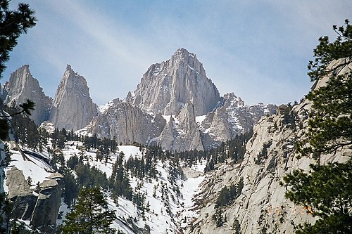
The highest points in the U.S. minor outlying islands, mostly unnamed:

See also

Notes

  1. 1 2 A high point may be (1.) a topographic summit, or (2.) a point on a border.
  2. 1 2 A low point may be (1.) the border crossing of a gulch, stream, or river; or (2.) the shore of a reservoir, lake, or ocean; or (3.) the bottom of an endorheic basin. The elevation of a stream, river, reservoir, or lake will vary seasonally. The bottom of an endorheic basin may fill with water.
  3. 1 2 The mean elevation of an area is the arithmetic average of all point elevations in the area.
  4. The median elevation of an area is the median of all point elevations in the area.
  5. 1 2 The elevation range of an area is the maximum elevation minus the minimum elevation.
  6. Coordinates are adjusted to the World Geodetic System of 1984 (WGS 84).
  7. Alaska has the highest point in North America and the greatest elevation range of any U.S. state.
  8. The summit of Denali is the highest point in the United States and all of North America. Denali is both the third most topographically prominent summit and the third most topographically isolated summit on Earth. Denali is the highest point in the entire Arctic Ocean Basin.
  9. Mount Magazine is the highest summit of the Ozarks.
  10. California has the lowest point in North America. California also has the highest point and greatest elevation range of any U.S. state except Alaska.
  11. Mount Whitney is the highest summit of the Sierra Nevada. Mount Whitney is the highest point of both the San Joaquin Basin and the Great Basin.
  12. The Badwater Basin, an endorheic basin in Death Valley, is the lowest point in the United States and all of North America. The Salton Sea, an endorheic basin with the lowest water level in North America, is currently near the −239.6-foot (−73.0 m) level. [14]
  13. Colorado has the highest mean elevation and the highest low point of any U.S. state.
  14. Mount Elbert is the highest summit of the Rocky Mountains of the United States and Canada. Mount Elbert is the highest point in the Mississippi River Basin.
  15. The point where the Arikaree River flows out of Colorado and into Kansas is the highest low point of any U.S. state, higher than the high points of 18 states and the District of Columbia.
  16. Connecticut is the only U.S. state with a high point that is not a topographic summit, although several other high points have a topographic prominence of less than 50 feet (15 m). The highest summit in Connecticut is Bear Mountain, approximately 1.45 miles (2.33 km) south-southeast; its exact elevation is disputed, but it is at least 60 feet (18 m) lower than the highest point on Mount Frissell in Connecticut. [18]
  17. Delaware has the lowest mean elevation of any U.S. state or the District of Columbia.
  18. Florida has the lowest high point and the smallest elevation range of any U.S. state or the District of Columbia.
  19. Britton Hill is the lowest high point of any U.S. state or the District of Columbia.
  20. Although only 1,332 feet (406 m) above sea level, the summit of Mount Lamlam is 195 miles (314 km) northeast and 37,160 feet (11,330 m) above the Challenger Deep.
  21. Mauna Kea is the highest summit of the island of Hawaiʻi and the entire North Pacific Ocean. Hawaiʻi is second only to New Guinea as the tallest island on Earth. Mauna Kea is the tallest mountain on Earth if measured from its base at −19,684 feet (−6,000 m) below the surface of the Pacific Ocean to its summit at 13,796 feet (4,205 m) for a total rise of 33,480 feet (10,205 m). [29] Neighboring Mauna Loa is the most voluminous mountain on Earth. [30]
  22. Charles Mound is approximately 1,300 feet (400 m) south of the Wisconsin border.
  23. Mount Sunflower is approximately 2,630 feet (800 m) east of the Colorado border.
  24. Louisiana is the only U.S. region with land below sea level outside of California.
  25. Mount Katahdin is the highest summit of the Longfellow Mountains.
  26. Mount Greylock is the highest summit of the Berkshires.
  27. The summit of Mount Arvon is the highest point on the Upper Peninsula of Michigan.
  28. Taum Sauk Mountain is the highest summit of the St. Francois Mountains.
  29. Granite Peak is the highest summit of the Beartooth Mountains.
  30. Panorama Point is approximately 2,210 feet (670 m) north of the Colorado border.
  31. The summit of Boundary Peak is approximately 1,440 feet (440 m) northeast of the California border.
  32. Mount Washington is the highest summit of the White Mountains. The summit of Mount Washington is the highest point on the northeastern Northern American continent.
  33. Wheeler Peak is the highest summit of the Taos Mountains.
  34. Mount Marcy is the highest summit of the Adirondack Mountains.
  35. Mount Mitchell is the highest summit of the Appalachian Mountains. The summit of Mount Mitchell is the highest point on the eastern Northern American continent.
  36. The summit of Mount Agrihan is the highest point in the Northern Mariana Islands and all of Micronesia. [65]
  37. Mount Hood is the highest summit of the Oregon Cascades.
  38. Puerto Rico has the highest point and greatest elevation range of any of the U.S. territories.
  39. Cerro de Punta is the highest point in any of the U.S. territories.
  40. Black Elk Peak is the highest summit of the Black Hills.
  41. Clingmans Dome is the highest summit of the Great Smoky Mountains.
  42. Guadalupe Peak is the highest summit of the Guadalupe Mountains.
  43. Kings Peak is the highest summit of the Uinta Mountains and the Western Rocky Mountains.
  44. Mount Mansfield is the highest summit of the Green Mountains.
  45. Mount Rainier is the highest summit of the Cascade Range of the United States and Canada.
  46. Gannett Peak is the highest summit of the Wind River Range and the Central Rocky Mountains. Gannett Peak is the highest point in the Green River Basin.

Related Research Articles

<span class="mw-page-title-main">Ruby Dome</span> Mountain in Nevada, United States

Ruby Dome is the highest mountain in both the Ruby Mountains and Elko County, in Nevada, United States. It is the twenty-seventh-highest mountain in the state, and also ranks as the thirteenth-most topographically prominent peak in the state. The peak is located about 21 miles (34 km) southeast of the city of Elko within the Ruby Mountains Ranger District of the Humboldt-Toiyabe National Forest. The mountain rises from a base elevation of about 6,000 feet (1,800 m) to a height of 11,387 feet (3,471 m). It is the highest mountain for over 90 miles in all directions.

<span class="mw-page-title-main">Mount Spokane</span> Mountain in Washington (state), United States

Mount Spokane [elevation 5,887 feet (1,794 m)]—previously known as Mount Baldy until 1912 due to its pronounced bald spot—is a mountain in the northwest United States, located northeast of Spokane, Washington. Its summit is the highest point in Spokane County, and it is one of the tallest peaks in the Inland Northwest. Mount Spokane is surrounded by Mount Spokane State Park, Washington's largest at 13,919 acres (56.3 km2). One of the well-known features is a bald spot on the corner of the west and south parts of the mountain.

<span class="mw-page-title-main">Pyramid Peak (California)</span> Mountain in the American state of California

Pyramid Peak is a mountain in the California's Sierra Nevada in the Crystal Range to the west of Lake Tahoe. It is the highest point in the Desolation Wilderness. With an elevation gain of almost 4,100 feet (1,250 m), the Rocky Canyon route is the mountain's most popular approach although it is very arduous. To the east, at the base of the peak, lies Pyramid Lake.

<span class="mw-page-title-main">Mount Lamborn</span> Mountain in Colorado, United States

Mount Lamborn is a mountain summit in the West Elk Mountains range of the Rocky Mountains of North America. The 11,402-foot (3,475 m) peak is located in Gunnison National Forest, 5.9 miles (9.5 km) southeast by south of the Town of Paonia in Delta County, Colorado, United States. The summit of Mount Lamborn is the highest point in Delta County. Together with nearby Landsend Peak to the southwest, it lies at the western edge of the West Elks, rising dramatically nearly 6,000 ft above the valley of the North Fork Gunnison River to the west.

Aspen Butte is a steep-sided shield volcano in the Cascade Range of southern Oregon. It is located 15 miles (24 km) south of Pelican Butte and 15 miles (24 km) southeast of Mount McLoughlin. It rises over 4,000 feet (1,200 m) above the nearby shore of Upper Klamath Lake. Ice Age glaciers carved three large cirques into the north and northeast flanks of the mountain removing most of the original summit area including any evidence of a crater. The summit is now the high point along the curving ridge which bounds the southern edge of the cirques above steep cliffs.

<span class="mw-page-title-main">Southern Rocky Mountains</span> Major subrange of the Rocky Mountains in the Western United States

The Southern Rocky Mountains are a major subregion of the Rocky Mountains of North America located in the southeastern portion of the U.S. state of Wyoming, the central and western portions of Colorado, the northern portion of New Mexico, and extreme eastern portions of Utah. The Southern Rocky Mountains are also commonly known as the Southern Rockies, and since the highest peaks are located in the State of Colorado, they are sometimes known as the Colorado Rockies, although many important ranges and peaks rise in the other three states. The Southern Rockies include the highest mountain ranges of the Rocky Mountains and include all 30 of the highest major peaks of the Rockies.

<span class="mw-page-title-main">Mount Stakes</span> Mountain in the state of California

Mount Stakes is a mountain in the Diablo Range in California. The peak is located on the Santa Clara–Stanislaus county line and is located less than 1 mile north of Henry W. Coe State Park. It rises to an elevation of 3,810 feet (1,161 m) and is the highest point in Stanislaus County. It is 22 miles (35 km) west of Newman and 32 miles (51 km) southeast of Livermore. Some snow falls on the peak during the winter.

<span class="mw-page-title-main">Mount Lola</span>

Mount Lola is a mountain in the Sierra Nevada of California. Its summit, located north of Donner Pass and Interstate 80, is the highest point in Nevada County. It is also the highest point in the Sierra Nevada north of Interstate 80. A subsidiary peak 1.2 miles (1.9 km) north of the main summit is highest point in Sierra County at 8,848 feet (2,697 m) NAVD 88.

Mount Tipton is a mountain in northwestern Arizona in the United States. With a summit elevation of 7,153 feet (2,180 m), it is the tallest mountain in the Cerbat Mountains which border Kingman on the north, and is the high point of the Mount Tipton Wilderness which comprises the entirety of the northern portion of the Cerbat Mountains. The community of Dolan Springs lies west at the base of Mount Tipton at the northwest side of the Cerbat Range.

Mount Ballard, with an elevation of 7,374 feet (2,248 m) is located in Cochise County, Arizona, about 1.8 miles (3 km) west of Bisbee.

For the mountain in California formerly named Summit Peak, see Mount Ina Coolbrith.

Hayford Peak, elevation 9,924 feet (3,025 m), is the highest mountain in the Sheep Range of Clark County, Nevada, United States. It is the seventh-most topographically prominent peak in the state. The nearest taller mountain is Mount Charleston, 34 miles (55 km) to the southwest. In the winter months, there is snow on the peak, which usually lasts until early spring.

References

  1. 1 2 3 "Highest and Lowest Elevations". United States Geological Survey, United States Department of the Interior . Retrieved August 27, 2022.
  2. "About HighPointer". HighPointer. 2021-05-13. Retrieved 2024-03-10.
  3. "Approximate mean elevation in each state or territory of the United States as of 2005". Statista . Retrieved 2022-09-05.
  4. "CHEEHAHAW". NGS Data Sheet. National Geodetic Survey, National Oceanic and Atmospheric Administration, United States Department of Commerce . Retrieved August 25, 2022.
  5. "Cheaha Mountain, Alabama". Peakbagger.com. Retrieved August 20, 2022.
  6. "Denali, Alaska". Peakbagger.com. Retrieved August 20, 2022.
  7. "Lata Mountain, American Samoa". Peakbagger.com. Retrieved August 20, 2022.
  8. "FRISCO". NGS Data Sheet. National Geodetic Survey, National Oceanic and Atmospheric Administration, United States Department of Commerce . Retrieved August 25, 2022.
  9. "Humphreys Peak, Arizona". Peakbagger.com. Retrieved August 20, 2022.
  10. "MAG". NGS Data Sheet. National Geodetic Survey, National Oceanic and Atmospheric Administration, United States Department of Commerce . Retrieved August 25, 2022.
  11. "Magazine Mountain, Arkansas". Peakbagger.com. Retrieved August 20, 2022.
  12. "WHITNEY". NGS Data Sheet. National Geodetic Survey, National Oceanic and Atmospheric Administration, United States Department of Commerce . Retrieved August 25, 2022.
  13. "Mount Whitney, California". Peakbagger.com. Retrieved August 20, 2022.
  14. "SALTON SEA NR WESTMORLAND CA". United States Geological Survey, United States Department of the Interior . Retrieved August 25, 2022.
  15. "MOUNT ELBERT". NGS Data Sheet. National Geodetic Survey, National Oceanic and Atmospheric Administration, United States Department of Commerce . Retrieved August 25, 2022.
  16. "Mount Elbert, Colorado". Peakbagger.com. Retrieved August 20, 2022.
  17. "Mount Frissell-South Slope, Connecticut/Massachusetts". Peakbagger.com. Retrieved August 20, 2022.
  18. "Bear Mountain, Connecticut". Peakbagger.com.
  19. "Ebright Azimuth, Delaware". Peakbagger.com. Retrieved August 20, 2022.
  20. "Highest Point in Delaware". Delaware Geological Survey. Archived from the original on October 5, 2011. Retrieved August 25, 2022.
  21. "Regarding the highest point in Delaware". Delaware Repeater Association. Archived from the original on July 26, 2011. Retrieved August 25, 2022.
  22. "Point Reno, District of Columbia". Peakbagger.com. Retrieved August 20, 2022.
  23. Dvorak, Petula. "D.C.'s Puny Peak Enough to Pump Up 'Highpointers'". The Washington Post . Retrieved January 1, 2015.
  24. "Britton Hill, Florida". Peakbagger.com. Retrieved August 20, 2022.
  25. "Brasstown Bald, Georgia". Peakbagger.com. Retrieved August 20, 2022.
  26. "Mount Lamlam, Guam". Peakbagger.com. Retrieved August 20, 2022.
  27. "SUMMIT USGS 1977". NGS Data Sheet. National Geodetic Survey, National Oceanic and Atmospheric Administration, United States Department of Commerce . Retrieved August 25, 2022.
  28. "Mauna Kea, Hawaii". Peakbagger.com. Retrieved August 20, 2022.
  29. "Tallest mountain". Guinness World Records . Retrieved August 25, 2022.
  30. Kaye, Grant D. "Using GIS to estimate the total volume of Mauna Loa volcano, Hawai'i". Archived from the original on 25 January 2009. Retrieved August 25, 2022.
  31. "BEAUTY RESET". NGS Data Sheet. National Geodetic Survey, National Oceanic and Atmospheric Administration, United States Department of Commerce . Retrieved August 25, 2022.
  32. "Borah Peak, Idaho". Peakbagger.com. Retrieved August 20, 2022.
  33. "CHARLES". NGS Data Sheet. National Geodetic Survey, National Oceanic and Atmospheric Administration, United States Department of Commerce . Retrieved August 25, 2022.
  34. "Charles Mound, Illinois". Peakbagger.com. Retrieved August 20, 2022.
  35. "Hoosier Hill, Indiana". Peakbagger.com. Retrieved August 20, 2022.
  36. "Hawkeye Point, Iowa". Peakbagger.com. Retrieved August 20, 2022.
  37. "Mount Sunflower, Kansas". Peakbagger.com. Retrieved August 20, 2022.
  38. "Black Mountain, Kentucky". Peakbagger.com. Retrieved August 20, 2022.
  39. "Driskill Mountain, Louisiana". Peakbagger.com. Retrieved August 20, 2022.
  40. "KATAHDIN 2". NGS Data Sheet. National Geodetic Survey, National Oceanic and Atmospheric Administration, United States Department of Commerce . Retrieved August 25, 2022.
  41. "Katahdin, Maine". Peakbagger.com. Retrieved August 20, 2022.
  42. "Backbone Mountain, Maryland". Peakbagger.com. Retrieved August 20, 2022.
  43. "GREYLOCK RM 1 RESET". NGS Data Sheet. National Geodetic Survey, National Oceanic and Atmospheric Administration, United States Department of Commerce.
  44. "Mount Greylock, Massachusetts". Peakbagger.com. Retrieved August 20, 2022.
  45. "Mount Arvon, Michigan". Peakbagger.com. Retrieved August 20, 2022.
  46. "Eagle Mountain, Minnesota". Peakbagger.com. Retrieved August 20, 2022.
  47. "KNOB RESET". NGS Data Sheet. National Geodetic Survey, National Oceanic and Atmospheric Administration, United States Department of Commerce.
  48. "Woodall Mountain, Mississippi". Peakbagger.com. Retrieved August 20, 2022.
  49. "Taum Sauk Mountain, Missouri". Peakbagger.com. Retrieved August 20, 2022.
  50. "GRANITE PEAK". NGS Data Sheet. National Geodetic Survey, National Oceanic and Atmospheric Administration, United States Department of Commerce . Retrieved August 25, 2022.
  51. "Granite Peak, Montana". Peakbagger.com. Retrieved August 20, 2022.
  52. "Panorama Point, Nebraska". Peakbagger.com. Retrieved August 20, 2022.
  53. "BOUNDARY". NGS Data Sheet. National Geodetic Survey, National Oceanic and Atmospheric Administration, United States Department of Commerce . Retrieved August 25, 2022.
  54. "Boundary Peak, Nevada". Peakbagger.com. Retrieved August 20, 2022.
  55. "MT WASHINGTON RESET". NGS Data Sheet. National Geodetic Survey, National Oceanic and Atmospheric Administration, United States Department of Commerce . Retrieved August 25, 2022.
  56. "Mount Washington, New Hampshire". Peakbagger.com. Retrieved August 20, 2022.
  57. "High Point, New Jersey". Peakbagger.com. Retrieved August 20, 2022.
  58. "WHEELER". NGS Data Sheet. National Geodetic Survey, National Oceanic and Atmospheric Administration, United States Department of Commerce . Retrieved August 25, 2022.
  59. "Wheeler Peak, New Mexico". Peakbagger.com. Retrieved August 20, 2022.
  60. "MARCY". NGS Data Sheet. National Geodetic Survey, National Oceanic and Atmospheric Administration, United States Department of Commerce . Retrieved August 25, 2022.
  61. "Mount Marcy, New York". Peakbagger.com. Retrieved August 20, 2022.
  62. "Mount Mitchell, North Carolina". Peakbagger.com. Retrieved August 20, 2022.
  63. "White Butte, North Dakota". Peakbagger.com. Retrieved August 20, 2022.
  64. "Agrihan High Point, Northern Marianas". Peakbagger.com. Retrieved August 20, 2022.
  65. Frick-Wright, Peter (January 15, 2019). "The Obsessive Quest of High Pointers". Outside . Retrieved August 19, 2022.
  66. "Campbell Hill, Ohio". Peakbagger.com. Retrieved August 20, 2022.
  67. "Black Mesa, Oklahoma". Peakbagger.com. Retrieved August 20, 2022.
  68. "MOUNT HOOD HIGHEST POINT". NGS Data Sheet. National Geodetic Survey, National Oceanic and Atmospheric Administration, United States Department of Commerce . Retrieved August 25, 2022.
  69. "Mount Hood, Oregon". Peakbagger.com. Retrieved August 20, 2022.
  70. "Mount Davis, Pennsylvania". Peakbagger.com. Retrieved August 20, 2022.
  71. "Cerro de Punta, Puerto Rico". Peakbagger.com. Retrieved August 20, 2022.
  72. "Jerimoth Hill, Rhode Island". Peakbagger.com. Retrieved August 20, 2022.
  73. "Sassafras Mountain, North Carolina/South Carolina". Peakbagger.com. Retrieved August 20, 2022.
  74. "BLACK ELK PEAK". NGS Data Sheet. National Geodetic Survey, National Oceanic and Atmospheric Administration, United States Department of Commerce . Retrieved August 13, 2016.
  75. "Black Elk Peak, South Dakota". Peakbagger.com. Retrieved August 20, 2022.
  76. "Clingmans Dome, North Carolina/Tennessee". Peakbagger.com. Retrieved August 20, 2022.
  77. "EL CAPITAN". NGS Data Sheet. National Geodetic Survey, National Oceanic and Atmospheric Administration, United States Department of Commerce . Retrieved August 25, 2022.
  78. "Guadalupe Peak, Texas". Peakbagger.com. Retrieved August 20, 2022.
  79. "Kings Peak, Utah". Peakbagger.com. Retrieved August 20, 2022.
  80. "MT MANSFIELD HIGHEST POINT". NGS Data Sheet. National Geodetic Survey, National Oceanic and Atmospheric Administration, United States Department of Commerce . Retrieved August 25, 2022.
  81. "Mount Mansfield, Vermont". Peakbagger.com. Retrieved August 20, 2022.
  82. "Crown Mountain, U.S. Virgin Islands". Peakbagger.com. Retrieved August 20, 2022.
  83. "ROGERS RESET". NGS Data Sheet. National Geodetic Survey, National Oceanic and Atmospheric Administration, United States Department of Commerce . Retrieved August 25, 2022.
  84. "Mount Rogers, Virginia". Peakbagger.com. Retrieved August 20, 2022.
  85. "Mount Rainier, Washington". Peakbagger.com. Retrieved August 20, 2022.
  86. "SPRUCE KNOB CAIRN 1956". NGS Data Sheet. National Geodetic Survey, National Oceanic and Atmospheric Administration, United States Department of Commerce . Retrieved August 25, 2022.
  87. "Spruce Knob, West Virginia". Peakbagger.com. Retrieved August 20, 2022.
  88. "Timms Hill, Wisconsin". Peakbagger.com. Retrieved August 20, 2022.
  89. "GANNETT PEAK CAIRN". NGS Data Sheet. National Geodetic Survey, National Oceanic and Atmospheric Administration, United States Department of Commerce . Retrieved August 25, 2022.
  90. "Gannett Peak, Wyoming". Peakbagger.com. Retrieved August 20, 2022.
  91. 1 2 "Navassa Island". The World Factbook . Central Intelligence Agency . Retrieved August 22, 2022.
  92. 1 2 3 4 5 6 7 "United States Pacific Island Wildlife Refuges". The World Factbook . Central Intelligence Agency . Retrieved August 22, 2022.
  93. "Wake Island". The World Factbook . Central Intelligence Agency. 2 August 2022. Retrieved August 22, 2022.