List of snowiest places in the United States by state

Last updated

The list of snowiest places in the United States by state shows average annual snowfall totals for the period from mid-1985 to mid-2015. Only places in the official climate database of the National Weather Service, a service of NOAA, are included in this list. Some ski resorts and unofficial weather stations report higher amounts of snowfall than places on this list. Official weather stations are usually located in populated places and snowfall statistics for isolated and unpopulated areas are often not recorded.

Mount Rainier and Mount Baker in Washington are the snowiest places in the United States which have weather stations, receiving 645 inches (1,640 cm) annually on average. By comparison, the populated place with the highest snowfall in the world is believed to be Sukayu Onsen in the Siberian-facing Japanese Alps. Sukayu Onsen receives 694.5 inches (1,764 cm) (nearly 58 feet) of snow annually. Nearby mountain slopes may receive even more. [1]

The amount of snow received at weather stations varies substantially from year to year. For example, the annual snowfall at Paradise Ranger Station in Mount Rainier National Park has been as little as 266 inches (680 cm) in 2014-2015 and as much as 1,122 inches (2,850 cm) in 1971–1972. [2]

Mount Rainier Mount Rainier from 30,000 feet.jpg
Mount Rainier
Skiing Mount Washington Tuckerman Ravine Stevage.jpg
Skiing Mount Washington
A Chicago snowstorm in 2011 Cars covered in Snow on Lake Shore Drive Chicago Feb 2 2011 storm.JPG
A Chicago snowstorm in 2011
Clearing a highway after a heavy snowfall in Oregon Rotary clears highway (4046721897).jpg
Clearing a highway after a heavy snowfall in Oregon
A blizzard at Altus Air Force Base in Oklahoma Snow Storm DVIDS362913.jpg
A blizzard at Altus Air Force Base in Oklahoma
Snow on Mauna Kea, Hawaii Hawaii Big Island Kona Hilo 063 (6878868712).jpg
Snow on Mauna Kea, Hawaii
Weather stations with highest snowfall in the United States by state, 1985-2015
StatePlaceAverage annual snowfall [3] elevation of weather station [4] coordinates [4] Other snowy areas (limited or unofficial data) and notes
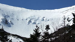
1. Washington Paradise, Mount Rainier 645.5 inches (1,640 cm)5,400 feet (1,600 m) 46°47′N121°44′W / 46.79°N 121.73°W / 46.79; -121.73 Mount Baker, 645 inches (1,640 cm) annually. [5]
2. Oregon Timberline Lodge Ski Area 551 inches (1,400 cm)5,960 feet (1,820 m) 45°20′N121°43′W / 45.33°N 121.71°W / 45.33; -121.71 Crater Lake, 533 inches (1,350 cm) annually. [6]
3. Utah Alta 456.9 inches (1,161 cm)8,730 feet (2,660 m) 40°36′N111°38′W / 40.60°N 111.64°W / 40.60; -111.64 Brighton Ski Resort, 411.1 inches (1,044 cm) annually. [7]
4. California Soda Springs 411.6 inches (1,045 cm) [8] 6,885 feet (2,099 m) 39°19′N120°23′W / 39.32°N 120.38°W / 39.32; -120.38 Sugar Bowl Ski Resort 2.5 miles east of Soda Springs, 500 inches (1,300 cm) annually. [9] Lake Helen at Mount Lassen [10] and Kalmia Lake in the Trinity Alps are estimated to receive 600-700 inches of snow per year. Tamarack in Calaveras County holds the record for the deepest snowfall on earth (884 inches (2,250 cm)).
5. Alaska Valdez 314.1 inches (798 cm)95 feet (29 m) 61°08′N146°21′W / 61.13°N 146.35°W / 61.13; -146.35 Alyeska Resort, 669 inches (1,700 cm) annually. [11]
6. New Hampshire Mount Washington 282.1 inches (717 cm)6,270 feet (1,910 m) 44°16′N71°18′W / 44.27°N 71.30°W / 44.27; -71.30 Elevation of weather station.
7. Colorado Climax 273.8 inches (695 cm)11,350 feet (3,460 m) 39°22′N106°11′W / 39.37°N 106.19°W / 39.37; -106.19 Wolf Creek Pass Ski Area. 387 inches (980 cm) annually. [12]
8. Wyoming Burgess Junction 257.8 inches (655 cm)8,050 feet (2,450 m) 44°46′N107°31′W / 44.77°N 107.52°W / 44.77; -107.52 Grand Targhee Resort, 500 inches (1,300 cm) annually. [9]
9. New York High Market (West Turin)214.2 inches (544 cm)1,816 feet (554 m) 43°21′N75°15′W / 43.35°N 75.25°W / 43.35; -75.25 Syracuse named snowiest city in U.S., 123.8 inches (314 cm) annually. [13]
10. Michigan Herman 214 inches (540 cm)1,667 feet (508 m) 46°40′N88°22′W / 46.67°N 88.37°W / 46.67; -88.37
11. Vermont Mount Mansfield 211.9 inches (538 cm)3,866 feet (1,178 m) 44°32′N72°49′W / 44.53°N 72.82°W / 44.53; -72.82 Jay Peak Resort, 350 inches (890 cm) annually. [14]
12. Idaho Island Park 211.8 inches (538 cm)6,298 feet (1,920 m) 44°25′N111°22′W / 44.42°N 111.37°W / 44.42; -111.37 Lookout Pass, 400 inches (1,000 cm) annually. [15]
13. South Dakota near Lead 195.9 inches (498 cm)6,120 feet (1,870 m) 44°14′N103°48′W / 44.24°N 103.80°W / 44.24; -103.80
14. Montana Mystic Lake 184.3 inches (468 cm)6,560 feet (2,000 m) 45°14′N109°44′W / 45.24°N 109.73°W / 45.24; -109.73 Cooke City, 200.7 inches (510 cm) annually. [16] Higher totals common at Big Sky.
15. West Virginia Terra Alta 175.0 inches (444 cm)2,582 feet (787 m) 39°27′N79°33′W / 39.45°N 79.55°W / 39.45; -79.55
16. Wisconsin Hurley 162.2 inches (412 cm)1,500 feet (460 m) 46°27′N90°11′W / 46.45°N 90.19°W / 46.45; -90.19
17. New Mexico Red River 151.1 inches (384 cm)8,661 feet (2,640 m) 36°43′N105°25′W / 36.71°N 105.41°W / 36.71; -105.41 Taos Ski Valley, 300 inches (760 cm) [17]
18. Maine Eustis 123.8 inches (314 cm)1,163 feet (354 m) 45°08′N70°26′W / 45.14°N 70.44°W / 45.14; -70.44
19. Arizona Bright Angel Ranger Station 118.4 inches (301 cm)8,320 feet (2,540 m) 36°13′N112°04′W / 36.21°N 112.06°W / 36.21; -112.06 Arizona Snowbowl, 260 inches (660 cm). [18] Sunrise Park Resort, 250 inches (640 cm). [19] Hawley Lake 168 inches (430 cm). [20]
20. Nevada Wild Horse Reservoir 118.2 inches (300 cm)6,265 feet (1,910 m) 41°40′N115°48′W / 41.67°N 115.80°W / 41.67; -115.80
21. Ohio Chardon 109.2 inches (277 cm)1,291 feet (393 m) 41°35′N81°12′W / 41.58°N 81.20°W / 41.58; -81.20
22. Maryland Oakland 105.9 inches (269 cm)2,408 feet (734 m) 39°25′N79°25′W / 39.41°N 79.41°W / 39.41; -79.41
23. Pennsylvania Erie 103.0 inches (262 cm)650 feet (200 m) 42°08′N80°05′W / 42.13°N 80.08°W / 42.13; -80.08
24. North Carolina Mount Mitchell 91 inches (230 cm)6,684 feet (2,037 m) 35°46′N82°16′W / 35.76°N 82.27°W / 35.76; -82.27
25. Minnesota Duluth 86.5 inches (220 cm)651 feet (198 m) 46°47′N92°06′W / 46.79°N 92.10°W / 46.79; -92.10
26. Tennessee Mount Le Conte 82.9 inches (211 cm)6,345 feet (1,934 m) 35°40′N83°26′W / 35.66°N 83.44°W / 35.66; -83.44
27. Connecticut Norfolk 77 inches (200 cm)1,167 feet (356 m) 41°59′N73°12′W / 41.99°N 73.20°W / 41.99; -73.20
28. Massachusetts Ashburnham 75.1 inches (191 cm)1,028 feet (313 m) 42°38′N71°55′W / 42.64°N 71.91°W / 42.64; -71.91
29. Indiana South Bend 66.8 inches (170 cm)752 feet (229 m) 41°41′N86°15′W / 41.68°N 86.25°W / 41.68; -86.25
30. Rhode Island North Foster 60.4 inches (153 cm)707 feet (215 m) 41°51′N71°46′W / 41.85°N 71.76°W / 41.85; -71.76
31. Virginia Wise 52.7 inches (134 cm)2,436 feet (742 m) 36°59′N82°35′W / 36.98°N 82.58°W / 36.98; -82.58
32. North Dakota Fargo 51.6 inches (131 cm)903 feet (275 m) 46°53′N96°47′W / 46.88°N 96.79°W / 46.88; -96.79
33. Nebraska Harrisburg 46.5 inches (118 cm)4,492 feet (1,369 m) 41°34′N103°44′W / 41.56°N 103.74°W / 41.56; -103.74
34. Iowa Dubuque 42.5 inches (108 cm)708 feet (216 m) 42°30′N90°40′W / 42.50°N 90.66°W / 42.50; -90.66
35. New Jersey Sussex 41.2 inches (105 cm)500 feet (150 m) 41°13′N74°37′W / 41.21°N 74.61°W / 41.21; -74.61
36. Illinois Chicago 38.5 inches (98 cm)858 feet (262 m) 41°53′N87°38′W / 41.88°N 87.63°W / 41.88; -87.63
37. Kansas McDonald 37.6 inches (96 cm)3,364 feet (1,025 m) 39°47′N101°22′W / 39.78°N 101.37°W / 39.78; -101.37
38. Kentucky Closplint 31.7 inches (81 cm)1,551 feet (473 m) 36°54′N83°04′W / 36.90°N 83.07°W / 36.90; -83.07
39. Oklahoma Boise City 30.8 inches (78 cm)4,175 feet (1,273 m) 36°44′N102°31′W / 36.73°N 102.51°W / 36.73; -102.51
40. Missouri Edina 22.0 inches (56 cm)795 feet (242 m) 40°10′N92°10′W / 40.17°N 92.17°W / 40.17; -92.17
41. Delaware Wilmington 21.9 inches (56 cm)114 feet (35 m) 39°14′N75°33′W / 39.24°N 75.55°W / 39.24; -75.55
42. Texas Stratford 20.2 inches (51 cm)3,699 feet (1,127 m) 36°20′N102°04′W / 36.34°N 102.07°W / 36.34; -102.07
43. Arkansas Gravette 16.0 inches (41 cm)1,211 feet (369 m) 36°25′N94°27′W / 36.42°N 94.45°W / 36.42; -94.45
44. South Carolina Caesars Head 7.2 inches (18 cm)3,180 feet (970 m) 35°07′N82°38′W / 35.11°N 82.63°W / 35.11; -82.63 Elevation of weather station
45. Alabama Valley Head 6.1 inches (15 cm)1,043 feet (318 m) 34°34′N85°37′W / 34.56°N 85.61°W / 34.56; -85.61
46. Georgia Dallas 3.8 inches (9.7 cm)994 feet (303 m) 33°56′N84°50′W / 33.93°N 84.84°W / 33.93; -84.84 Highest peaks in Appalachian Mountains get ca. 35 inches (89 cm) annually. [21]
47. Mississippi Hickory Flat 2.9 inches (7.4 cm)435 feet (133 m) 34°37′N89°11′W / 34.62°N 89.19°W / 34.62; -89.19
48. Louisiana Shreveport 0.8 inches (2.0 cm)225 feet (69 m) 32°31′N93°45′W / 32.51°N 93.75°W / 32.51; -93.75
49. Florida Milton 0.2 inches (0.51 cm)9 feet (2.7 m) 30°38′N87°02′W / 30.63°N 87.04°W / 30.63; -87.04
50. Hawaii 0.0 inches (0 cm)Occasional snow above 6,200 feet (1,900 m) elevation. [22] The Mauna Loa Observatory  at an elevation of 11,150 feet (3,400 m) averages 3.7 inches (9.4 cm) of snow per year. [23]

Related Research Articles

<span class="mw-page-title-main">Richfield, Utah</span> City in the United States

Richfield is a city in and the county seat of Sevier County, Utah, United States, and is the largest city in southern-central Utah.

<span class="mw-page-title-main">Santa Cruz Mountains</span> Mountain range in California, United States

The Santa Cruz Mountains are a mountain range in central and Northern California, United States, constituting a part of the Pacific Coast Ranges. They form a ridge down the San Francisco Peninsula, south of San Francisco. They separate the Pacific Ocean from the San Francisco Bay and the Santa Clara Valley, and continue south to the Central Coast, bordering Monterey Bay and ending at the Salinas Valley. The range passes through the counties of San Mateo, Santa Clara, and Santa Cruz, with the Pajaro River forming the southern boundary.

<span class="mw-page-title-main">Ōkura, Yamagata</span> Village in Tōhoku, Japan

Ōkura is a village in Yamagata Prefecture, Japan. As of January 2020, the village has an estimated population of 3044, and a population density of 14 persons per km2. The total area is 211.59 square kilometres (82 sq mi).

<span class="mw-page-title-main">Alta Ski Area</span> Ski resort in Alta, Utah, United States

Alta is a ski area in the western United States, located in the town of Alta in the Wasatch Mountains of Utah, in Salt Lake County. With a skiable area of 2,614 acres (10.58 km2), Alta's base elevation is 8,530 ft (2,600 m) and rises to 11,068 ft (3,374 m) for a vertical gain of 2,538 ft (774 m). One of the oldest ski resorts in the country, it opened its first lift in early 1939. Alta is known for receiving more snow than most Utah resorts, with an average annual snowfall of 545 inches (13.8 m). It is also regularly ranked as having the best snow in North America. Alta is one of three remaining ski resorts in the U.S. that prohibits snowboarders, along with nearby competitor Deer Valley and Vermont's Mad River Glen.

<span class="mw-page-title-main">Uonuma</span> City in Chūbu, Japan

Uonuma is a city located in Niigata Prefecture, Japan. As of 1 July 2019, the city had an estimated population of 35,027 in 13,289 households, and a population density of 37 persons per km2. Its total area is 946.76 square kilometres (365.55 sq mi). The city is famous for its koshihikari rice, which commands a premium in the Japanese market.

<span class="mw-page-title-main">Niseko, Hokkaido</span> Town in Hokkaido, Japan

Niseko is a town located in Shiribeshi Subprefecture, Hokkaido, Japan. To Japanese people, Niseko principally refers to a mountain range and a municipal area. However, overseas the name has come to refer to a wider area of ski resorts encompassing Hokkaido's Mount Yōtei, often referred to as the "Mt. Fuji of Hokkaido", and Annupuri ranges. The name Niseko derives from the Ainu language, and it means "a cliff jutting over a riverbank deep in the mountains". The Niseko town's main industries are agriculture and tourism. The resort itself, Niseko United, is part of the Mountain Collective. Moreover, the town is renowned for its quality powder snow and world-class facilities, including traditional onsen and restaurants.

<span class="mw-page-title-main">Bakuriani</span> Borough and Resort in Samtskhe-Javakheti, Georgia

Bakuriani is a daba and a ski resort in the Borjomi district of Georgia. It is located on the northern slope of the Trialeti Range, at an elevation of 1,700 meters above sea level.

<span class="mw-page-title-main">Sukayu Onsen</span> Hot spring in Aomori Prefecture, Japan

Sukayu Onsen is an onsen in the Hakkōda Mountains in the city of Aomori, Aomori Prefecture in Japan. It is known for its "Sen-nin-buro" or "Bath of a thousand bathers", a large mixed gender public bath.

<span class="mw-page-title-main">Camelback Mountain Resort</span> Ski and snowboard resort in Pennsylvania

Camelback Resort is a 4 seasons resort located in Tannersville, Pennsylvania in the Pocono Mountains.

<span class="mw-page-title-main">Bear Creek Mountain Resort</span> Ski area in Pennsylvania, United States

Bear Creek is a ski resort in Longswamp Township, Berks County, Pennsylvania. The resort opened in 1967 and was known as the Doe Mountain until 1999. It is a year-round resort on more than 330 acres (1.3 km2) that features a variety of activities and amenities.

<span class="mw-page-title-main">Climate of California</span> Overview of the climate of the U.S. state of California

The climate of California varies widely from hot desert to alpine tundra, depending on latitude, elevation, and proximity to the Pacific Coast. California's coastal regions, the Sierra Nevada foothills, and much of the Central Valley have a Mediterranean climate, with warmer, drier weather in summer and cooler, wetter weather in winter. The influence of the ocean generally moderates temperature extremes, creating warmer winters and substantially cooler summers in coastal areas.

Tamarack, formerly known as Camp Tamarack, is an unincorporated community in Calaveras County, California in the United States. It was founded in the 1920s. A nearby weather station, located across the Alpine County line, has been the site of several United States meteorological records.

<span class="mw-page-title-main">Paradise, Washington</span> Unincorporated community in Washington, United States

Paradise is the name of an area at approximately 5,400 feet (1,600 m) on the south slope of Mount Rainier in Mount Rainier National Park in Washington, United States. Southeast of Seattle, the area lies on the border of Pierce and Lewis counties and includes the Paradise Valley and the Paradise Glacier, the source of the Paradise River. Virinda Longmire named Paradise in the summer of 1885 while she viewed the wildflowers in the alpine meadows there. Paradise also offers views of Mount Rainier and the Tatoosh Range.

<span class="mw-page-title-main">Cooke City, Montana</span> Census-designated place in Montana, United States

Cooke City is an unincorporated community and census-designated place (CDP) in Park County, Montana, United States. As of the 2020 census, it had a population of 77. Prior to 2010, it was part of the Cooke City-Silver Gate CDP.

<span class="mw-page-title-main">Thompson Pass</span>

Thompson Pass is a 2,600 foot-high gap in the Chugach Mountains northeast of Valdez, Alaska. It is the snowiest place in Alaska, recording 500 inches (1,300 cm) of snow per year on average. In the winter of 1952–1953, 974.1 inches (2,474 cm) of snow fell—the most ever recorded in one season at one location in Alaska. It is also the most snow ever recorded in one season at one location anywhere in the fifty states. The pass also holds the Alaska record for the most snow in a single day: 62 inches (160 cm) fell on December 29, 1955.

<span class="mw-page-title-main">Geography of Washington (state)</span> Overview of the Geography of Washington

Washington is the northwesternmost state of the contiguous United States. It borders Idaho to the east, bounded mostly by the meridian running north from the confluence of the Snake River and Clearwater River, except for the southernmost section where the border follows the Snake River. Oregon is to the south, with the Columbia River forming the western part and the 46th parallel forming the eastern part of the Oregon–Washington border. During Washington's partition from Oregon, the original plan for the border followed the Columbia River east until the confluence with the Snake, and then would have followed the Snake River east; this was changed to keep Walla Walla's fertile farmland in Washington.

<span class="mw-page-title-main">2018–19 North American winter</span> North American winter of 2018–19

The 2018–19 North American winter was unusually cold within the Northern United States, with frigid temperatures being recorded within the middle of the season. Several notable events occurred, such as a rare snow in the Southeast in December, a strong cold wave and several major winter storms in the Midwest, and upper Northeast and much of Canada in late January and early February, record snowstorms in the Southwest in late February, deadly tornado outbreaks in the Southeast and a historic mid-April blizzard in the Midwest, but the most notable event of the winter was a record-breaking bomb cyclone that affected much of the Central United States and Canada in mid-March. Unlike previous winters, a developing weak El Niño was expected to influence weather patterns across North America. Overall, however, winter of 2018–19 was mild along the mid- and lower parts of the East Coast, the West Coast, and most of the southern Plains. Overall, the meteorological winter of 2018-19 became the wettest on record for the United States.

<span class="mw-page-title-main">Mount Lincoln (California)</span> Mountain in the state of California

Mount Lincoln is an 8,383-foot-elevation (2,555 meter) mountain summit in Placer County, California, United States.

<span class="mw-page-title-main">Mount Judah</span> Mountain in the state of California

Mount Judah is an 8,243-foot-elevation (2,512 meter) mountain summit in Placer County, California, United States.

<span class="mw-page-title-main">November 2022 Great Lakes winter storm</span> Winter storm in November 2022

The November 2022 Great Lakes winter storm was a lake-effect winter storm that affected parts of Pennsylvania, Ohio, and New York. The winter storm caused high accumulations of snow across the Great Lakes region, with several locations receiving 50 in (130 cm) of snowfall across New York, with Hamburg, New York receiving 81.2 in (206 cm) and Orchard Park, New York recording 80 in (200 cm) of snow. At least four fatalities occurred, with three in New York and one in Indiana, and several highways closed after heavy snowfall. A travel ban was also issued for New York by governor Kathy Hochul, and thundersnow occurred across areas impacted by the winter storm.

References

  1. "Record Snow Depth (For an official site) Measured in Japan | Weather Extremes". www.wunderground.com. Retrieved 27 Apr 2019.
  2. Ashford, Mailing Address: 55210 238th Avenue East; Us, WA 98304 Phone: 360 569-2211 Contact. "Annual Snowfall Totals - Mount Rainier National Park (U.S. National Park Service)". www.nps.gov. Retrieved 2022-06-28.
  3. "The snowiest place in each state," The Weather Channel, accessed 23 Apr 2019. Archived 4 June 2019 at the Wayback Machine
  4. 1 2 Google Earth
  5. "Washington ski areas". www.thesnowjunkies.com. Archived from the original on 26 April 2019. Retrieved 26 Apr 2019.
  6. "The Top 9 Snowiest Ski Resorts in North America". snowbrains.com. 30 September 2019. Retrieved 26 Apr 2019.
  7. "Brighton UT Snowfall Totals & Snow Accumulation Averages - Current Results". www.currentresults.com. Retrieved 26 Apr 2019.
  8. "SODA SPRINGS 1 E, Minnesota - Climate Summary". wrcc.dri.edu. Retrieved 2022-06-28.
  9. 1 2 "Top Snowiest Ski Resorts in the USA". snowbrains.com. 7 June 2021. Retrieved 26 Apr 2019.
  10. McLaughlin, Mark. "Weather Window: The snowiest spot in California is Lake Helen near Lassen Volcanic National Park". www.sierrasun.com. Retrieved 2020-07-14.
  11. "10 Ski Resorts with the Deepest Snow in America". www.nationalgeographic.com. 31 January 2017. Retrieved 27 Apr 2019.
  12. "Wolf Creek Ski Resort | Snowiest Ski Resort in Colorado". www.zrankings.com. Retrieved 26 Apr 2019.
  13. "Top 25 Snowiest Cities in America". www.niche.com. Retrieved 26 Apr 2019.
  14. "The Mountain | Jay Peak Resort". jaypeakresort.com. Retrieved 2021-08-11.
  15. "Idaho Ski Resorts Listed by Vertical Drop and Snowfall". Visit Sun Valley. 2016-09-26. Retrieved 2022-06-28.
  16. "Average Annual Snowfall Totals in Montana - Current Results". www.currentresults.com. Retrieved 26 Apr 2019.
  17. "Taos Ski Valley Official Tourism and Travel Website". Taos Ski Valley Official Tourism and Travel Website. Retrieved 2022-06-28.
  18. "Snowmaking". Arizona Snowbowl. Retrieved 2022-10-12.
  19. "Sunrise Park Resort Ski Resort | SkiCentral.com". www.skicentral.com. Retrieved 2022-10-12.
  20. "HAWLEY LAKE, ARIZONA - Climate Summary". wrcc.dri.edu. Retrieved 2022-10-12.
  21. "AT Snowfall Maps - weathercarrot". weathercarrot.smugmug.com. Retrieved 27 Apr 2019.
  22. Graff, Amy (2019-02-11). "Hawaii recorded what may be the lowest elevation snow in state history". SFGATE. Retrieved 2022-06-28.
  23. "MAUNA LOA SLOPE OBS 39, HAWAII - Climate Summary".