Climate of Beaumont, Texas

Last updated

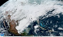
The Climate of Beaumont, Texas covers the averages and extremes in past weather seen within the city of Beaumont, Texas. The city is within the humid subtropical climate regime, [1] and is within the Piney Woods region of eastern Texas. [2] The area around Beaumont receives the most rainfall in the state: more than 65 inches (1,700 mm) annually. Summers in the area are usually hot and humid, due to the moisture that flows inland off of the Gulf of Mexico. Winters are usually kept mild by the warm gulf waters. Hurricanes also pose a threat to the area. Hurricane Harvey in 2017, Hurricane Rita in 2005, and Hurricane Ike in 2008 were the most recent significant storms to strike.

Contents

Temperature

Summers in the area are usually hot and humid, due to the moisture that flows inland off of the Gulf of Mexico. Winters are usually kept mild by the warm gulf waters.

Monthly normal high and low temperatures (°F) for Beaumont/Port Arthur, Texas
JanFebMarAprMayJunJulAugSepOctNovDec
62/4365/4672/5278/5984/6689/7292/7492/7388/6980/6071/5164/44
[3]

Precipitation

The Beaumont area receives the most rainfall in the state: more than 65 inches (1,700 mm) annually. This is due to the warm gulf waters that carry humid air to the region, where it condenses and precipitates. The city itself and much of the region has a wet season from April to October and a dry season from November to March.

Wintry Precipitation

While wintry precipitation is unusual, it does occur. The most recent significant wintry event to occur was December 8, 2017 when the Southeast Texas Regional Airport recorded 3 inches of snowfall. [4] December 11, 2008 [5] and December 4, 2009 [6] were also days that Beaumont saw measurable snowfall. Snow also fell across the Beaumont area on Christmas Eve 2004. [7] In January 1997, a severe and historic ice storm struck the region, leaving thousands without power and major tree damage in its wake. [8] In unofficial records, Beaumont received as much as 30 inches of snow during the blizzard of February 1895 that impacted the Gulf Coast. [9] In February 2021 Winter Storm Uri struck all of the state, affecting Beaumont. Power outages were reported but the main issues were low water pressure and crippled travel. Record cold followed the storm and Beaumont plunged all the way down to 14 degrees Fahrenheit. Snow and sleet totals were 1-2 inches throughout most of the region. On February 17, Winter Storm Viola caused freezing rain around the area. Accumulations were measured at 0.01-0.10 inches. Many homes and businesses in the region suffered from busted water pipes from these two events.

Winter Storm Uri moving east after hitting the state of Texas and other southern states. Winter Storm Uri February 15 2021.jpg
Winter Storm Uri moving east after hitting the state of Texas and other southern states.

Severe Weather

Hurricanes and Tropical Storms

Hurricane Rita (2005) Rita 2005-09-21 1610Z.jpg
Hurricane Rita (2005)

In October 1886, a category 3 hurricane came ashore near Sabine Pass, a coastal community southeast of Beaumont, causing widespread wind damage and coastal flooding in the area.

In 1957, Hurricane Audrey, a category 3 hurricane, roared ashore near the Sabine River, causing major coastal flooding and wind damage. At least 416 people lost their lives (other estimates show over 500), mostly in Louisiana due to drowning from storm surge. [10]

In 1961, Hurricane Carla affected the entire Texas coastline from Jefferson County to Brownsville. Carla caused $2.6 billion (2006 dollars) in damage. [10] The Beaumont area received wind damage, tornadoes, and flooding from the storm.

In 1963, Hurricane Cindy, a category 1 hurricane, affected the upper Texas coast and western Louisiana. Much of the storm's damage was due to flooding resulting from over 20 inches of rain. 4,000 homes in Jefferson, Orange, and Newton counties were flooded. [11]

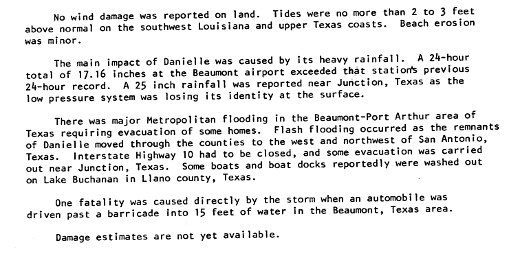
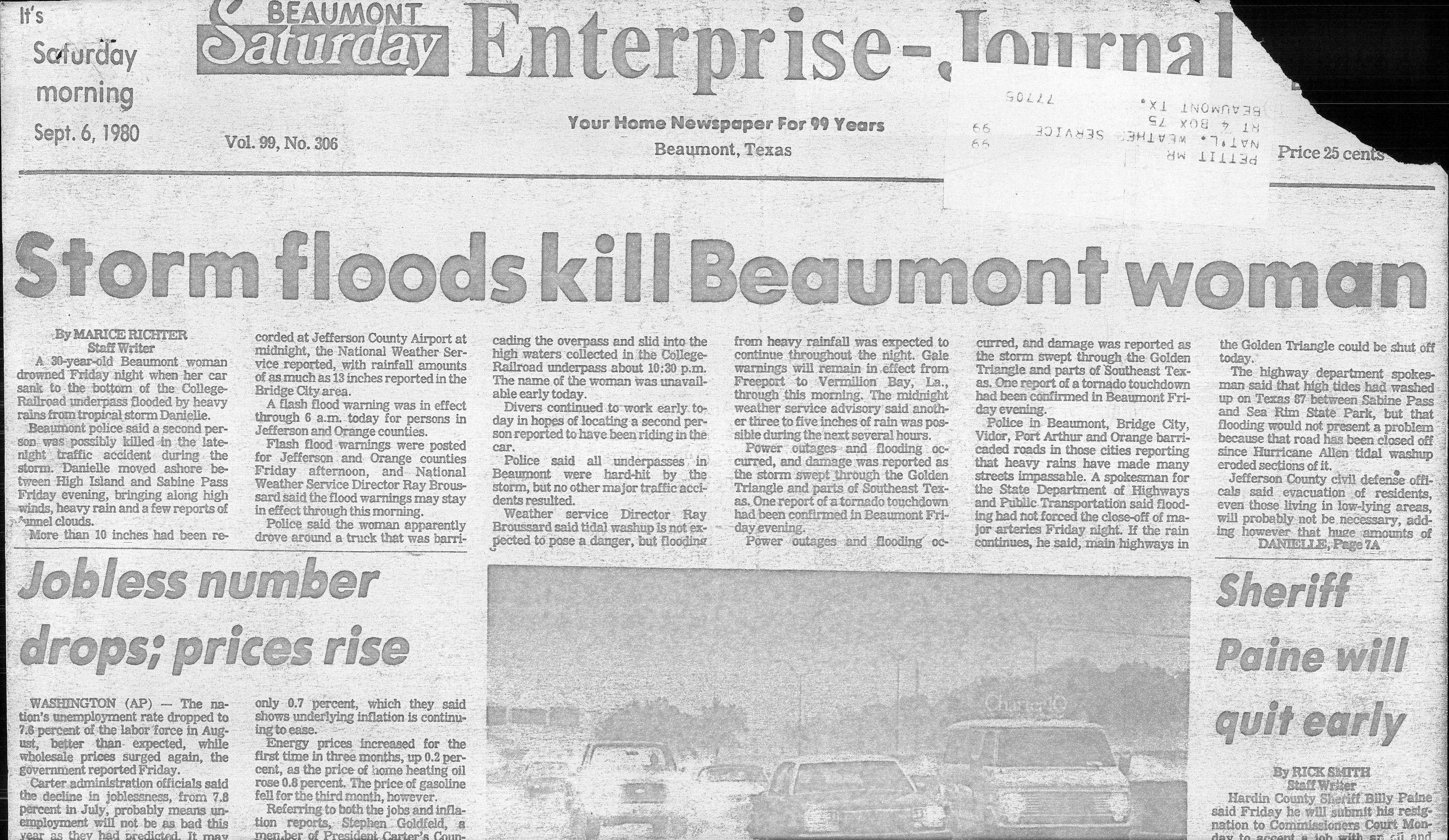
In 1980, Tropical Storm Danielle struck the area. The primary impact from Danielle was flooding. A National Hurricane Center preliminary report noted "...There was major Metropolitan area flooding in the Beaumont-Port Arthur area of Texas requiring evacuation of some homes....One fatality was caused directly by the storm when an automobile was driven beyond a barricade into 15 feet of water in Beaumont, Texas." [12] [13]

In 1983, Hurricane Alicia struck the Texas coast west of the Beaumont area; however, the city did receive light impacts from the storm. [14]

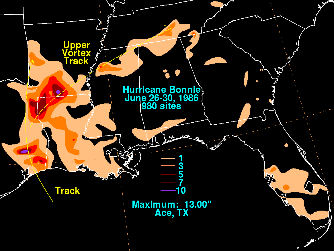
In June 1986, Hurricane Bonnie hit the Beaumont area as a category 1 hurricane. The storm's primary impact was flooding from heavy rain. Some locations near the city received 5 inches (130 mm) to 10 inches (250 mm) of rain, [15] flooding many homes and businesses. Three people lost their lives due to Bonnie.

In June 2001, Tropical Storm Allison struck the upper Texas coast. The worst impacts were felt west of the Beaumont area, but the city and the surrounding area still suffered damage from flooding. 7 inches (180 mm) to 10 inches (250 mm) of rain fell in and around Beaumont, causing widespread issues on roadways throughout the area. [16]

On September 24, 2005, Hurricane Rita made landfall near the Texas/Louisiana border as a category 3 hurricane with 120 mph winds. The storm moved northward through the Beaumont-Port Arthur Metropolitan Area and areas north, damaging or destroying many buildings. Thousands of trees were downed across the area, and power was knocked out to hundreds of thousands of residents. In advance of the storm, one of the largest evacuations in U.S. history took place, as millions of people fled the coastal areas of Texas. Hurricane Rita was the worst hurricane to strike the Beaumont area since Audrey in 1957. A total of $12 billion in damages occurred and 7 people lost their lives due to the storm. [17]

On September 13, 2007, category 1 Hurricane Humberto struck the area, causing minor impacts.

On September 13, 2008, Hurricane Ike struck the upper Texas coast as a category 2 hurricane, causing major wind damage and storm surge flooding. Many buildings sustained damage in Beaumont, although the strongest winds remained west of the city. In total, Ike caused $31 billion in damages and 112 people lost their lives in the storm.

In August 2017, Hurricane Harvey struck the lower Texas Coast as a Category 4 hurricane, weakened, and stalled shortly after landfall. As the storm drifted offshore and began to slowly move northeast, heavy rainfall caused severe flooding all across Southeast Texas. In the Beaumont area, thousands of homes received flood damage and multiple rescues had to be performed, by both boat and helicopter. In Nederland, a city just southeast of Beaumont, 60.58" of rain fell as a result of Harvey, setting a national rainfall record for the amount of rainfall produced by a tropical system.

In August 2020, Hurricane Laura threatened to strike Beaumont and Southeast Texas as a Category 3 hurricane. Mandatory Evacuations were issued, but Laura went further east than expected and the city was spared from its worst impacts. The highest recorded sustained wind was at 48 miles an hour and the highest recorded gust was at 74 miles an hour at Beaumont Municipal Airport.

On October 9, 2020, Hurricane Delta made landfall in Creole, Louisiana as a 100 mph Category 2 Hurricane. Beaumont and surrounding areas experienced strong winds causing trees to fall and many power outages. The highest recorded sustained winds were at 65 mph and gusts to 90 mph at Jack Brooks Regional Airport.o

Hurricane Delta rapidly intensifying south of the Yucatan Peninsula Remnants of Gamma and Hurricane Delta.gif
Hurricane Delta rapidly intensifying south of the Yucatán Peninsula

See also

Related Research Articles

<span class="mw-page-title-main">Hurricane Isidore</span> Category 3 Atlantic hurricane in 2002

Hurricane Isidore was a powerful tropical cyclone that caused widespread flooding and heavy damage across Mexico, Cuba, and the United States in September 2002. The ninth named storm and the second hurricane in the 2002 Atlantic hurricane season, and the fifth of eight named storms to occur in September of that year, Isidore peaked as a Category 3 hurricane, causing damage, as well as four fatalities in Jamaica, Cuba, Mexico, and the United States. Isidore is also noted for threatening to strike the northern Gulf Coast as a Category 4 hurricane, however, the storm struck the region as a moderately-strong tropical storm, due to a track change that brought the storm over the Yucatán Peninsula for over a day, which significantly weakened the cyclone in the process. The primary impact from the storm was the heavy rainfall, which fell across southeast Mexico, and also from the central United States Gulf coast into the Ohio Valley.

<span class="mw-page-title-main">Hurricane Carla</span> Category 4 Atlantic hurricane in 1961

Hurricane Carla was the most intense tropical cyclone landfall in Texas in the 20th century. The third named storm of the 1961 Atlantic hurricane season, Carla developed from an area of squally weather in the southwestern Caribbean Sea on September 3. Initially a tropical depression, it strengthened slowly while heading northwestward, and by September 5, the system was upgraded to Tropical Storm Carla. About 24 hours later, Carla was upgraded to a hurricane. Shortly thereafter, the storm curved northward while approaching the Yucatán Channel. Late on September 7, Carla entered the Gulf of Mexico while passing just northeast of the Yucatán Peninsula. By early on the following day, the storm became a major hurricane after reaching Category 3 intensity. Resuming its northwestward course, Carla continued intensification and on September 11, became what would today be classified as a Category 4 hurricane. Later that day, Carla weakened slightly but was still a large and intense hurricane when the storm made landfall near Port O'Connor, Texas. It weakened quickly inland and was reduced to a tropical storm on September 12. Heading generally northward, Carla transitioned into an extratropical cyclone on September 13, while centered over southern Oklahoma. Rapidly moving northeastward, Carla's remnants reached the Labrador Sea, Canada and dissipated on September 17, 1961.

<span class="mw-page-title-main">Hurricane Rita</span> Category 5 Atlantic hurricane in 2005

Hurricane Rita was the most intense tropical cyclone on record in the Gulf of Mexico and the fourth-most intense Atlantic hurricane ever recorded. Part of the record-breaking 2005 Atlantic hurricane season, which included three of the top ten most intense Atlantic hurricanes in terms of barometric pressure ever recorded, Rita was the seventeenth named storm, tenth hurricane, and fifth major hurricane of the 2005 season. It was also the earliest-forming 17th named storm in the Atlantic until Tropical Storm Rene in 2020. Rita formed near The Bahamas from a tropical wave on September 18, 2005 that originally developed off the coast of West Africa. It moved westward, and after passing through the Florida Straits, Rita entered an environment of abnormally warm waters. Moving west-northwest, it rapidly intensified to reach peak winds of 180 mph (285 km/h), achieving Category 5 status on September 21. However, it weakened to a Category 3 hurricane before making landfall in Johnson's Bayou, Louisiana, between Sabine Pass, Texas and Holly Beach, Louisiana, with winds of 115 mph (185 km/h). Rapidly weakening over land, Rita degenerated into a large low-pressure area over the lower Mississippi Valley by September 26th.

<span class="mw-page-title-main">Tropical Storm Allison (1989)</span> Atlantic tropical storm in 1989

Tropical Storm Allison was a tropical cyclone that produced severe flooding in the southern United States. The second tropical cyclone and the first named storm of the 1989 Atlantic hurricane season, Allison formed on June 24 in the northwestern Gulf of Mexico. Development of Allison was a result of the interaction of a tropical wave and the remnants of Pacific hurricane Hurricane Cosme. It moved south and became a tropical storm on June 26. By June 27, Allison made landfall near Freeport, Texas. Allison quickly weakened to a tropical depression later that day, and transitioned into an extratropical cyclone on the following day. However, the storm's remnants persisted for another 10 days and meandered across the area, triggering flooding across the region, before dissipating on July 7.

<span class="mw-page-title-main">Tropical Storm Matthew (2004)</span> Atlantic tropical storm in 2004

Tropical Storm Matthew was a weak tropical storm in the 2004 Atlantic hurricane season that made landfall on Louisiana. It was the thirteenth tropical storm of the season and the ninth to affect the United States. It formed over the western Gulf of Mexico on October 8 and struck south-central Louisiana two days later. The combination of the storm and an upper cyclone over the southern Plains brought heavy rains to much of the Gulf Coast, with the highest amounts reported over 15 inches (380 mm) in northern Louisiana. Damage was minimal, totaling $305,000 (2004 USD), and no casualties were reported.

<span class="mw-page-title-main">Tropical Storm Claudette (1979)</span> Atlantic tropical storm in 1979

Tropical Storm Claudette was a 1979 tropical cyclone which was the third-wettest tropical cyclone on record in the contiguous United States. The storm caused significant flooding in eastern Texas and western Louisiana in July 1979. The eighth tropical cyclone and third named storm of the 1979 Atlantic hurricane season, Claudette developed from a tropical wave located east of the Windward Islands on July 16. It gradually strengthened and was upgraded to a tropical storm on July 17 and crossed the northern Leeward Islands later that day. As it neared landfall in Puerto Rico early on July 18, upper-level winds weakened it back to a tropical depression. Claudette remained disorganized and the National Hurricane Center operationally reported that it degenerated back into a tropical wave after crossing Puerto Rico. Late on July 18, the depression struck Dominican Republic, emerged into the Caribbean Sea on the following day. Claudette struck western Cuba on July 21, shortly before reaching the Gulf of Mexico and "regenerating" into a tropical cyclone. By July 23, Claudette regained tropical storm intensity and turned northward toward the Gulf Coast of the United States. The storm made landfall near the Texas-Louisiana border late on July 23 as a moderately strong tropical storm. It weakened slowly and drifted over land, lasting until dissipation in West Virginia on July 29.

<span class="mw-page-title-main">Tropical Storm Frances (1998)</span> Atlantic tropical storm in 1998

Tropical Storm Frances caused extensive flooding in Mexico and Texas in September 1998. The sixth tropical cyclone and sixth named storm of the annual hurricane season, Frances developed from a low pressure area in the Gulf of Mexico on September 8. The cyclone moved northward through the western Gulf of Mexico, making landfall across the central Texas coastline before recurving across the Midwest through southeast Canada and New England. A large tropical cyclone for the Atlantic basin, yet an average sized system by western Pacific standards, the storm produced heavy rains across the Isthmus of Tehuantepec, Texas, western Louisiana and the Great Plains.

<span class="mw-page-title-main">Tropical Storm Charley (1998)</span> Atlantic tropical storm in 1998

Tropical Storm Charley was the third named storm of the 1998 Atlantic hurricane season. Charley was the first of two tropical storms to make landfall in Texas during that season. The storm originated with a tropical wave that moved off the West African coast on August 9. The wave moved generally west-northwestward, producing occasional bursts of convection, finally arriving in the southeastern Gulf of Mexico by August 19, when animated satellite images began to indicate it had possibly developed a low pressure center. Hurricane Hunter investigations into the system the next day revealed that this was not the case. The system lingered for two days, lacking an organized low level center of circulation until early on the morning of August 21, when advisories were initiated on the tropical depression, 185 miles (298 km) east of Brownsville, Texas. The depression became a tropical storm later that day, as it moved steadily west-northwestward, strengthening, and then weakening again before making landfall the next morning around Port Aransas, Texas. The storm moved slowly inland and finally dissipated on the morning of the August 24 near the town of Del Rio, Texas.

<span class="mw-page-title-main">Tropical Storm Fay (2002)</span> Atlantic tropical storm in 2002

Tropical Storm Fay was the sixth named storm of the 2002 Atlantic hurricane season; it was a moderate tropical storm which caused flooding in parts of Texas and Northern Mexico. It formed from a trough of low pressure that moved south into the Gulf of Mexico, and became stationary. A low pressure center developed along this trough, and on September 5, a Hurricane Hunter aircraft reported that the system had gained sufficient organization to be classified a tropical depression, 95 miles (153 km) southeast of Galveston. The depression drifted south-southwest while strengthening, reaching its peak strength of 60 miles per hour (97 km/h) on the morning of September 6. The system then made an abrupt turn to the west-northwest, and remained steady in strength and course until landfall the next day, near Matagorda. The system weakened rapidly after landfall degenerating into a remnant low on September 8, but the storm's circulation survived for another three days.

<span class="mw-page-title-main">Tropical Storm Dean (1995)</span> Atlantic tropical storm in 1995

Tropical Storm Dean was a short-lived storm that formed in late July 1995 and lasted into early August. It was the fourth named storm of the 1995 Atlantic hurricane season. It spent most of its life as a tropical depression, and briefly gained tropical storm status before its landfall on the Texas coast on July 30. After landfall, it dissipated over central Texas on August 2. The impacts from Dean were minimal, mainly due to heavy rain in Oklahoma and Texas that caused localized coastal and inland flooding. Two F0 Tornadoes touched down in Texas as a result of Dean's landfall. Also, Twenty families had to be evacuated in Chambers County, due to flooding in the area. One fatality was recorded as a result of flooding in Oklahoma. Several highways were flooded out in Oklahoma, which impeded travel in the state. In addition approximately $500,000 worth of damage was recorded in the aftermath of Dean.

The climate of Houston is classified as a humid subtropical climate, with tropical influences. August normally ranks as the warmest month at 84.6 °F (29.2 °C) and January the coldest month at 53.1 °F (11.7 °C).

<span class="mw-page-title-main">Tropical Storm Chris (1982)</span> Atlantic tropical storm in 1982

Tropical Storm Chris caused minor flooding along the Gulf Coast of the United States in September 1982. The fifth tropical or subtropical cyclone and third named storm of the 1982 Atlantic hurricane season, Chris developed from a surface low-pressure area in the northern Gulf of Mexico on September 9. Although initially displaying subtropical characteristics, the low pressure area gradually acquired tropical characteristics, and was reclassified as Tropical Depression Four within 24 hours of development. The depression then began to intensify and was upgraded to Tropical Storm Chris on September 10. Thereafter, the storm turned north-north-eastward and strengthened further. On September 11, Chris peaked as a 65 mph (100 km/h) tropical storm. Later that day, it made landfall near Sabine Pass, Port Arthur, Texas. By September 13, Chris dissipated over Arkansas.

<span class="mw-page-title-main">Climate of Texas</span> Overview of the climate of the U.S. state of Texas

Texas' weather varies widely, from arid in the west to humid in the east. The huge expanse of Texas encompasses several regions with distinctly different climates: Northern Plains, Trans-Pecos Region, Texas Hill Country, Piney Woods, and South Texas. Generally speaking, the part of Texas that lies to the east of Interstate 35 is subtropical, while the portion that lies to the west of Interstate 35 is arid desert.

<span class="mw-page-title-main">Hurricane Humberto (2007)</span> Category 1 Atlantic hurricane in 2007

Hurricane Humberto was a Category 1 hurricane that formed and intensified faster than any other North Atlantic tropical cyclone on record, before landfall. The ninth named storm and third hurricane of the 2007 Atlantic hurricane season, Humberto developed on September 12, 2007, in the northwestern Gulf of Mexico,. The tropical cyclone rapidly strengthened and struck High Island, Texas, with winds of about 90 mph (140 km/h) early on September 13. It steadily weakened after moving ashore, and on September 14, Humberto began dissipating over northwestern Georgia as it interacted with an approaching cold front.

<span class="mw-page-title-main">Tropical Storm Danielle (1980)</span> Atlantic tropical storm in 1980

Tropical Storm Danielle caused considerable flooding in the state of Texas during September 1980. The eighth tropical cyclone and fourth named storm of the 1980 Atlantic hurricane season, Danielle developed from a tropical wave that emerged into the Atlantic Ocean from the west coast of Africa on August 22. Three days later, the tropical wave developed into a tropical depression. Four days later, the depression degenerated into a tropical wave. After tracking westward and entering the Gulf of Mexico, the system gradually developed, and became a tropical depression on September 4. The depression gradually strengthened and became Tropical Storm Danielle only hours before landfall in eastern Texas on September 5. Danielle steadily weakened inland and dissipated two days later.

<span class="mw-page-title-main">Tropical Storm Imelda</span> Atlantic tropical storm in 2019

Tropical Storm Imelda was a tropical cyclone which was the fourth-wettest storm on record in the U.S. state of Texas, causing devastating and record-breaking floods in southeast Texas. The eleventh tropical cyclone and ninth named storm of the 2019 Atlantic hurricane season, Imelda formed out of an upper-level low that developed in the Gulf of Mexico and moved westward. Little development occurred until the system was near the Texas coastline, where it rapidly developed into a tropical storm before moving ashore shortly afterward on September 17. Imelda weakened after landfall, but continued bringing large amounts of flooding rain to Texas and Louisiana, before dissipating on September 21.

References

  1. Thomas J. Larkin and George W. Bomar. Climatic Atlas of Texas. Archived 2006-07-06 at the Wayback Machine Retrieved on 2008-03-19.
  2. "Piney Woods forests". Terrestrial Ecoregions. World Wildlife Fund. Retrieved on 2008-03-19.
  3. U. S. Travel Weather . com. Texas. Archived 2008-03-25 at the Wayback Machine Retrieved on 2008-03-19.
  4. December 8, 2017 Snowfall
  5. December 11, 2008 Snowfall
  6. December 4, 2009 Snowfall
  7. Christmas Eve 2004 Snowfall
  8. January 1997 Ice Storm
  9. Gulf Coast Blizzard of 1895
  10. 1 2 Eric S. Blake, Edward N. Rappaport, and Chris Landsea. The Dealiest, Costliest, and Most Intense United States Tropical Cyclones From 1851 to 2006 (and other frequently requested hurricane facts). Retrieved on 2008-03-19.
  11. "The Hurricane Season of 1963" (PDF). Monthly Weather Review. December 8, 1964. pp. 131–132. Retrieved October 2, 2015.
  12. "Tropical Storm Danielle Preliminary Report". National Hurricane Center. Retrieved October 2, 2015.
  13. "Storm floods kill Beaumont woman". Beaumont Enterprise-Journal. September 6, 1980. Retrieved October 2, 2015.
  14. "Hurricanes: Alicia, 1983". Beaumont Enterprise. July 13, 2010. Retrieved October 2, 2015.
  15. David M. Roth. Hurricane Bonnie Color-Filled Rainfall Graphic. Retrieved on 2008-03-19.
  16. David M. Roth. Allison (2001) Color-Filled Rainfall Graphic for Extreme Southeast Texas. Retrieved on 2008-03-19.
  17. National Hurricane Center. Atlantic Hurricane Database. Retrieved on 2008-03-19.