Coastal flooding occurs when dry and low-lying land is submerged (flooded) by seawater. [1] The range of a coastal flooding is a result of the elevation of floodwater that penetrates the inland which is controlled by the topography of the coastal land exposed to flooding. [1] [2] The seawater can flood the land via several different paths: direct flooding, overtopping or breaching of a barrier. [3] Coastal flooding is largely a natural event. Due to the effects of climate change (e.g. sea level rise and an increase in extreme weather events) and an increase in the population living in coastal areas, the damage caused by coastal flood events has intensified and more people are being affected. [4]
Contents
- Types
- Causes
- Storms and storm surges
- Sea level rise
- Tidal flooding
- Tsunami waves
- Impacts
- Social and economic impacts
- Environmental impacts
- Reduction and control
- Flood control
- Non-structural mechanisms
- Engineered defenses
- Natural defenses
- Longer term aspects and research
- Examples
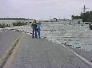
- Hurricane Katrina in New Orleans
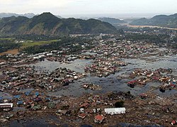
- Indonesia and Japan earthquake-related tsunamis
- See also
- References
- Sources
Coastal areas are sometimes flooded by unusually high tides, such as spring tides, especially when compounded by high winds and storm surges. This was the cause of the North Sea flood of 1953 which flooded large swathes of the Netherlands and the East coast of England.
When humans modify the coastal environment this can make coastal flooding worse. [1] [5] [6] [7] Extraction of water from groundwater reservoirs in the coastal zone can instigate subsidence of the land, thus increasing the risk of flooding. [5] Engineered protection structures along the coast, such as sea walls, alter the natural processes of the beach. This can lead to erosion on adjacent stretches of the coast which also increases the risk of flooding. [1] [7] [8]
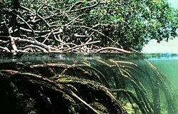
Reduction and control of coastal flooding is carried out using structural methods to hold back or redirect flood waters. Non-structural methods include coastal management, behavioral and institutional response to adapt to the processes. Natural defenses include physical features like gravel bars and sand dune systems, but also ecosystems such as salt marshes, seagrass and mangrove forests which have a buffering function. Mangroves, wetlands and seagrass meadows are often considered to provide significant protection against storm waves, tsunamis, and shoreline erosion through their ability to attenuate wave energy. [6] [9] [10] To protect the coastal zone from flooding, the natural defenses should, therefore, be protected and maintained in for example Marine Protected Areas (MPAs). [11]