
Bolivar Peninsula is a census-designated place (CDP) in Galveston County, Texas, United States. The population was 2,417 at the 2010 census. The communities of Port Bolivar, Crystal Beach, Caplen, Gilchrist, and High Island are located on Bolivar Peninsula.

A tornado warning is a public warning that is issued by weather forecasting agencies to an area in the direct path of a tornado or a thunderstorm that is capable of producing a tornado. Modern weather surveillance technology such as Doppler weather radar allow for early detection of rotation in a thunderstorm, and for subsequent warnings to be issued before a tornado actually develops. It is nevertheless still not uncommon that warnings are issued based on reported visual sighting of a tornado, funnel cloud, or wall cloud, typically from weather spotters or the public, but also law enforcement or local emergency management. In particular, a tornado can develop in a gap of radar coverage, of which there are several known in the United States.

A severe thunderstorm warning is a type of public warning for severe weather that is issued by weather forecasting agencies worldwide when one or more severe thunderstorms have been detected by Doppler weather radar, observed by weather spotters, or reported by an emergency management agency, law enforcement, or the general public. Unlike a watch, a warning is issued to areas in the direct path of active severe thunderstorms, that are expecting a direct impact typically within an hour. Severe thunderstorms can cause property damage and injury due to large hail, high winds, and flooding due to torrential rainfall. The exact criteria to issue a warning varies from country to country.

Hurricane Alicia was a small but powerful tropical cyclone that caused significant destruction in the Greater Houston area of Southeast Texas in August 1983. Although Alicia was a relatively small hurricane, its track over the rapidly growing metropolitan area contributed to its $3 billion damage toll, making it the costliest Atlantic hurricane at the time. Alicia spawned from a disturbance that originated from the tail-end of a cold front over the northern Gulf of Mexico in mid-August 1983. The cyclone was named on August 14 when it became a tropical storm, and the combination of weak steering currents and a conducive environment allowed Alicia to quickly intensify as it drifted slowly westward. On August 17, Alicia became a hurricane and continued to strengthen, topping out as a Category 3 major hurricane as it made landfall on the southwestern end of Galveston Island. Alicia's eye passed just west of Downtown Houston as the system accelerated northwestwards across East Texas; Alicia eventually weakened into a remnant area of low pressure over Oklahoma on August 20 before they were last noted on August 21 over eastern Nebraska.

A rip current is a specific type of water current that can occur near beaches where waves break. A rip is a strong, localized, and narrow current of water that moves directly away from the shore by cutting through the lines of breaking waves, like a river flowing out to sea. The force of the current in a rip is strongest and fastest next to the surface of the water.
A rip tide, or riptide, is a strong offshore current that is caused by the tide pulling water through an inlet along a barrier beach, at a lagoon or inland marina where tide water flows steadily out to sea during ebb tide. It is a strong tidal flow of water within estuaries and other enclosed tidal areas. The riptides become the strongest where the flow is constricted. When there is a falling or ebbing tide, the outflow water is strongly flowing through an inlet toward the sea, especially once stabilized by jetties.

Galveston Bay is a bay in the western Gulf of Mexico along the upper coast of Texas. It is the seventh-largest estuary in the United States, and the largest of seven major estuaries along the Texas Gulf Coast. It is connected to the Gulf of Mexico and is surrounded by sub-tropical marshes and prairies on the mainland. The water in the bay is a complex mixture of sea water and fresh water, which supports a wide variety of marine life. With a maximum depth of about 10 feet (3 m) and an average depth of only 6 feet (2 m), it is unusually shallow for its size.

Galveston Island is a barrier island on the Texas Gulf Coast in the United States, about 50 miles (80.5 km) southeast of Houston. The entire island, with the exception of Jamaica Beach, is within the city limits of the City of Galveston in Galveston County.

This article describes severe weather terminology used by the National Weather Service (NWS) in the United States. The NWS, a government agency operating as an arm of the National Oceanic and Atmospheric Administration (NOAA) branch of the United States Department of Commerce (DoC), defines precise meanings for nearly all of its weather terms.

The Bolivar Bridge was a proposed bridge connecting Galveston Island and the Bolivar Peninsula in the United States state of Texas. Its intention was to replace the Bolivar Ferry, the only direct connection for traffic from Galveston Island.
In weather forecasting in the United States, "particularly dangerous situation" (PDS) is enhanced wording used by the National Weather Service to convey special urgency in some watch or warning messages when there is a significant risk of extreme weather, most commonly from types of weather events that are usually less severe by comparison, such as a severe thunderstorm outbreak or flash flooding. It is used in the format "This is a particularly dangerous situation..." at the discretion of the issuing forecaster. A watch or warning bearing the phrase is referred to as a PDS watch or PDS warning as shorthand jargon.
A significant weather advisory was a hazardous weather statement issued by certain Weather Forecast Offices (WFO) of the National Weather Service (NWS) in the United States to alert the public of thunderstorm activity that is below designated severe criteria for and/or is not expected to produce severe weather. The title assigned to the advisory — alternately titled "significant weather alert" or referenced by its originating product, "special weather statement" — varied by the issuing WFO.

San Luis Pass is a passage of water on the Texas Gulf Coast of the United States. It connects the sheltered waters of West Bay to the open Gulf of Mexico between Galveston Island and San Luis Island.
In National Weather Service (NWS) terminology, a Hazardous Weather Outlook is a weather statement issued to provide information of potential severe weather events within the next seven days. The outlook may include information about potential severe thunderstorms, heavy rain or flooding, winter weather, extremes temperatures.

The effects of Hurricane Ike in Texas were crippling and long-lasting. Ike's effects included deaths, widespread damage, and impacts to the price and availability of oil and gas. Hurricane Ike also had a long-term impact on the U.S. economy. Making landfall over Galveston, at 2:10 a.m. CDT on September 13, 2008, Category 2 Hurricane Ike caused extensive damage in Texas, with sustained winds of 110 mph (180 km/h), a 22 ft (6.7 m) storm surge, and widespread coastal flooding.
An excessive heat watch is a notice issued by the National Weather Service of the United States when the heat index is expected to be greater than 105 °F (41 °C) across the northern states or 110 °F (43 °C) across the southern states during the day, and/or nighttime low temperature will be at least 75 °F (24 °C) or higher for two consecutive days. Note that even with the usual northern/southern criteria, local offices, particularly those with deserts or mountainous terrain, often have their own criteria. High values of the heat index are caused by temperatures being significantly above normal and high humidities, and such high levels can pose a threat to human life through conditions such as heat stroke.
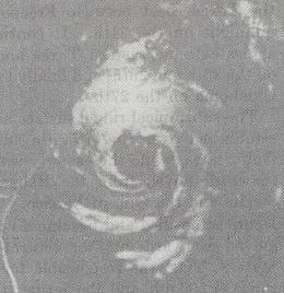
Hurricane Debra was a destructive tropical cyclone that developed during the 1959 Atlantic hurricane season. The fifth tropical storm and third hurricane of the season, Debra originated from the interaction of a cold-core low and a tropical wave on July 15. The system was designated a tropical depression on July 23 when it was south of Louisiana and meandered westward while it swiftly intensified into a tropical storm along the Gulf Coast of the United States. A turn towards the northwest became evident as it attained Category 1 hurricane status on the Saffir–Simpson Hurricane Scale the following day while it organized into a developed storm. As the hurricane curved northward at a slow forward speed, strength was maintained as it approached the coast of Texas as a minimal hurricane. It came ashore during the evening of July 24 local time between Freeport and Galveston, Texas. It rapidly weakened into a tropical storm and later a depression as it moved inland, and dissipated on July 28 while it turned northwestward. The remnant moisture later sparked upper-level thunderstorms in late July and early August.
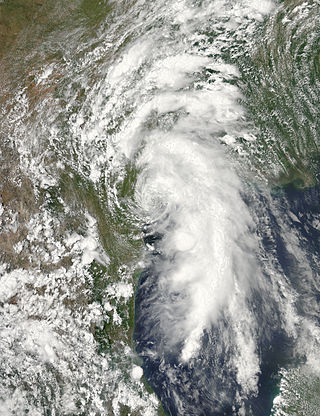
Tropical Storm Bill was a tropical cyclone that produced widespread rainfall across East Texas, Oklahoma, the Midwest, and Mid-Atlantic. The second named storm of the season, Bill developed from a broad area of low pressure over the northwestern Gulf of Mexico on June 16. Because the system was already producing tropical storm force winds, it was immediately classified as Tropical Storm Bill. Initially continuing northwestward, Bill re-curved west-northwestward later on June 16. Around 12:00 UTC, the storm peaked with maximum sustained winds of 60 mph (95 km/h). Just under five hours later, Bill made landfall near on Matagorda Island, Texas, at the same intensity. The cyclone weakened to a tropical depression and turned northward early on June 17. Bill remained a tropical cyclone until late on June 18, when it degenerated into a remnant low. The remnant low moved east-northeastward until dissipating over West Virginia on June 21.
A freeze watch is a notice issued by the National Weather Service that announces that temperatures of 32 °F (0 °C) and below is possible in the next 48 hours. This watch is only issued during the growing season when the freezing temperature may damage or kill unharvested crops, which would end the growing season. Farmers are advised to prepare protecting their remaining crops and monitor the forecast.

The U.S. state of Texas has a series of estuaries along its coast on the Gulf of Mexico, most of them bounded by the Texas barrier islands. Estuaries are coastal bodies of water in which freshwater from rivers mixes with saltwater from the sea. Twenty-one drainage basins terminate along the Texas coastline, forming a chain of seven major and five minor estuaries: listed from southwest to northeast, these are the Rio Grande Estuary, Laguna Madre, the Nueces Estuary, the Mission–Aransas Estuary, the Guadalupe Estuary, the Colorado–Lavaca Estuary, East Matagorda Bay, the San Bernard River and Cedar Lakes Estuary, the Brazos River Estuary, Christmas Bay, the Trinity–San Jacinto Estuary, and the Sabine–Neches Estuary. Each estuary is named for its one or two chief contributing rivers, excepting Laguna Madre, East Matagorda Bay, and Christmas Bay, which have no major river sources. The estuaries are also sometimes referred to by the names of their respective primary or central water bodies, though each also includes smaller secondary bays, inlets, or other marginal water bodies.