Related Research Articles
A winter storm warning is a hazardous weather statement issued by Weather Forecast Offices (WFO) of the National Weather Service (NWS) in the United States to alert the public that a winter storm is occurring or is about to occur in the area, usually within 36 hours of the storm's onset.
A winter weather advisory is a hazardous weather statement issued by Weather Forecast Offices (WFO) of the National Weather Service in the United States when one or more types of winter precipitation—snow, rain and snow mixed, freezing rain, sleet, graupel, etc.—presenting a hazard, but not expected to produce accumulations meeting storm warning criteria, are forecast within 36 hours of the expected onset of precipitation or are occurring in the advisory's coverage area.
A blowing snow advisory was issued by the National Weather Service of the United States when wind driven snow reduces surface visibility and possibly hampers traveling. Blowing snow may be falling snow, or snow that has already accumulated but is picked up and blown by strong winds. This advisory was discontinued beginning with the 2008–09 winter storm season, replaced by the winter weather advisory for snow and blowing snow. However, if the storm is judged to be dangerous by local forecasters, a winter storm warning for heavy snow and blowing snow may be issued.
A winter storm watch is issued by the National Weather Service of the United States when there is a possibility of heavy snow or potential of significant ice accumulations, without meeting a specific other winter criteria. The watch is typically issued 12 to 48 hours before the storm's expected arrival in the given area. The criteria for this watch can vary from place to place, which is true with other winter weather warning and advisories.
A lake effect snow advisory was issued by the National Weather Service of the United States when lake effect snow may pose a hazard or is life-threatening. The snow must be completely caused by a convective snow development over a lake and not by a low pressure system. The criteria for this advisory vary from area to area.

An ice storm warning is a hazardous weather statement issued by the Weather Forecast Offices of the National Weather Service in the United States which indicates that freezing rain produces a significant and possibly damaging accumulation of ice on surfaces. The criteria for this warning vary from state to state, but typically an ice storm warning will be issued any time more than 1⁄4 inch (6.4 mm) of ice at peak is expected to accumulate in an area, else a freezing rain or drizzle advisory is issued; in some areas, the criterion is 1⁄2 inch (13 mm) instead.
A heavy snow warning was a hazardous weather statement issued by the Weather Forecast Offices of the National Weather Service (NWS) in the United States which indicates a high rate of snowfall was occurring or was forecast to occur. Generally, the warning was issued for snowfall rates of 6 inches (15 cm) or more in 12 hours, or 8 inches (20 cm) or more in 24 hours.

This article describes severe weather terminology used by the National Weather Service (NWS) in the United States. The NWS, a government agency operating as an arm of the National Oceanic and Atmospheric Administration (NOAA) branch of the United States Department of Commerce (DoC), defines precise meanings for nearly all of its weather terms.
A lake effect snow warning is a bulletin issued by the National Weather Service in the United States to warn of heavy snowfall accumulations that are imminent from convective snow generated by very cold airmass passing over unfrozen lakes. The criteria for amounts may vary significantly over different county warning areas. On October 2, 2017, some National Weather Service Forecast Offices discontinued issuing the Lake Effect Snow Warning, and consolidated it with the Winter Storm Warning. On October 15, 2018, the National Weather Service discontinued issuing Lake Effect Snow Warnings nationwide all together, and all offices consolidated it with the Winter Storm Warning. Lake effect snow warnings were reinstated for the 2019–20 winter season.
This article describes severe weather terminology used by the Meteorological Service of Canada, a branch within Environment and Climate Change Canada. The article primarily describes various weather warnings, and their criteria. Related weather scales and general weather terms are also addressed in this article. Some terms are specific to certain regions.
A particularly dangerous situation (PDS) tag is enhanced wording first used by the Storm Prediction Center (SPC), a national guidance center of the United States National Weather Service, for tornado watches and eventually expanded to use for other severe weather watches and warnings by local NWS forecast offices. It is issued at the discretion of the forecaster composing the watch or warning and implies that there is an enhanced risk of very severe and life-threatening weather, usually a major tornado outbreak or a long-lived, extreme derecho event, but possibly another weather hazard such as an exceptional flash flood or wildfire.
A flash flood watch is severe weather watch product of the National Weather Service that is issued when conditions are favorable for flash flooding in flood-prone areas, usually when grounds are already saturated from recent rains, or when upcoming rains will have the potential to cause a flash flood. These watches are also occasionally issued when a dam may break in the near future.

A blizzard warning is a hazardous weather statement issued by Weather Forecast Offices (WFO) of the National Weather Service (NWS) in the United States, which indicates heavy snowfall accompanied by sustained winds or frequent gusts of 35 mph (56 km/h) or greater are forecast to occur for a minimum of three hours. A blizzard tends to reduce visibilities to 1⁄4 mile (400 m) or less. A Severe Blizzard Warning is a variation issued in some cases of winds above 45 mph (72 km/h) and temperatures below 10 °F (−12 °C). Most local weather offices will activate and broadcast the SAME alarm tone on relevant NOAA Weather Radio stations for both varieties of warning. When the Wireless Emergency Alerts system was launched in 2012, blizzard warnings were initially sent as alerts to mobile phones; this practice was discontinued in November 2013.
A blizzard watch was a bulletin issued by the National Weather Service of the United States which meant winds greater than 35 miles per hour, mixed with falling or blowing snow, and visibilities of 1⁄4 mile (0.4 km) or less is forecast for a period of 3 hours or more. A blizzard watch was issued 12 to 48 hours before an expected blizzard event. As the forecast solidifies, a blizzard watch would be either downgraded to a winter storm warning or winter weather advisory for blowing snow or upgraded to a blizzard warning.
A freeze warning is a warning issued by the National Weather Service when sub-freezing temperatures are expected in the next 36 hours. This can occur with or without frost. When a freeze warning is issued in the fall, that will usually signify the end of the growing season, as sub-freezing temperatures will usually kill all remaining crops. Farmers and gardeners should take action to protect or harvest their herbaceous plants if a freeze warning is issued. A freeze warning is issued several hours after a freeze watch if a freeze continues to be expected.
A freezing rain advisory was an advisory issued by the National Weather Service in the United States when freezing rain or freezing drizzle was expected to cause significant inconveniences, but did not meet warning criteria.
A wind chill watch is issued by the National Weather Service of the United States when the wind chill could reach dangerous levels within the next 12 to 48 hours. The exact definition required to issue a watch varies from state to state or from National Weather Service county warning areas to another, but if forecasters believe conditions are favorable for life-threatening wind chills meeting local criteria, a watch will be issued. People going outside should plan to protect themselves against hypothermia and frostbite.
A wind chill warning is a hazardous weather statement issued by local forecast offices of the National Weather Service (NWS) in the United States and previously by the Meteorological Service of Environment and Climate Change Canada (ECCC) when wind chills are forecast to reach values low enough for residents and travelers to be susceptible to life-threatening medical conditions or death associated with accelerated body heat loss.

The November 26 – December 3, 2019 North American blizzard was a major winter storm from the Rocky Mountains to the Northeast as well as a record-breaking windstorm along the West Coast. It occurred the week of American Thanksgiving, hampering travel for millions across the United States.
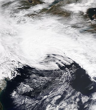
The April 2021 nor'easter, also referred to as the 2021 Spring nor'easter, was a significant late-season nor'easter that impacted much of New England with heavy snowfall, gusty winds, thundersnow, and near-whiteout conditions from April 15–17, 2021. The system originated from a weak frontal system late on April 14 over North Carolina, which moved into the ocean the next day and began to strengthen. The low-pressure steadily deepened as it moved up the East Coast, and developed an eye-like feature just prior to peak intensity. It prompted a fairly large area of Winter Storm Warnings across interior sections of New England, with Winter Weather Advisories being issued closer to the coast. Over 20,000 customers lost power at the height of the storm on April 16 due to heavy wet snow, and near-whiteout conditions were reported in many areas. Several injuries, some serious, occurred as well, mostly due to traffic incidents on poorly-treated roadways during the storm. Damage estimates from the system are currently not calculated.