Related Research Articles

A small craft advisory is a type of wind warning issued by the National Weather Service in the United States. In Canada a similar warning is issued by Environment Canada. It is issued when winds have reached, or are expected to reach within 12 hours, a speed marginally less than gale force. A Small Craft Advisory may also be issued when sea or lake ice exists that could be hazardous to small boats.
A gale warning is an alert issued by national weather forecasting agencies around the world in an event that maritime locations currently or imminently experiencing winds of gale force on the Beaufort scale. Gale warnings allow mariners to take precautionary actions to ensure their safety at sea or to seek safe anchorage and ride out the storm on land. Though usually associated with deep low-pressure areas, winds strong enough to catalyze a gale warning can occur in other conditions too, including from anticyclones, or high-pressure systems, in the continental interior. The winds are not directly associated with a tropical cyclone.
A winter weather advisory is a hazardous weather statement issued by Weather Forecast Offices (WFO) of the National Weather Service in the United States when one or more types of winter precipitation—snow, rain and snow mixed, freezing rain, sleet, graupel, etc.—presenting a hazard, but not expected to produce accumulations meeting storm warning criteria, are forecast within 36 hours of the expected onset of precipitation or are occurring in the advisory's coverage area.
A winter storm watch is issued by the National Weather Service of the United States when there is a possibility of heavy snow or potential of significant ice accumulations, without meeting a specific other winter criteria. The watch is typically issued 12 to 48 hours before the storm's expected arrival in the given area. The criteria for this watch can vary from place to place, which is true with other winter weather warning and advisories.

At sea, a storm warning is a warning issued by the National Weather Service of the United States when winds between 48 knots and 63 knots are occurring or predicted to occur soon. The winds must not be associated with a tropical cyclone. If the winds are associated with a tropical cyclone, a tropical storm warning will be substituted for the storm warning and less severe gale warning.

This article describes severe weather terminology used by the National Weather Service (NWS) in the United States. The NWS, a government agency operating as an arm of the National Oceanic and Atmospheric Administration (NOAA) branch of the United States Department of Commerce (DoC), defines precise meanings for nearly all of its weather terms.
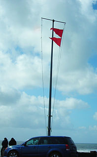
A red flag warning is a forecast warning issued by the National Weather Service in the United States to inform the public, firefighters, and land management agencies that conditions are ideal for wildland fire combustion, and rapid spread. After drought conditions, when humidity is very low, and especially when there are high or erratic winds which may include lightning as a factor, the Red Flag Warning becomes a critical statement for firefighting agencies. These agencies often alter their staffing and equipment resources dramatically to accommodate the forecast risk. To the public, a Red Flag Warning means high fire danger with increased probability of a quickly spreading vegetation fire in the area within 24 hours.
A particularly dangerous situation (PDS) tag is enhanced wording first used by the Storm Prediction Center (SPC), a national guidance center of the United States National Weather Service, for tornado watches and eventually expanded to use for other severe weather watches and warnings by local NWS forecast offices. It is issued at the discretion of the forecaster composing the watch or warning and implies that there is an enhanced risk of very severe and life-threatening weather, usually a major tornado outbreak or a long-lived, extreme derecho event, but possibly another weather hazard such as an exceptional flash flood or wildfire.
A flash flood watch is issued by the National Weather Service when conditions are favorable for flash flooding in flood-prone areas, usually when grounds are already saturated from recent rains, or when upcoming rains will have the potential to cause a flash flood. These watches are also occasionally issued when a dam may break in the near future.
A blizzard watch was a bulletin issued by the National Weather Service of the United States which meant winds greater than 35 miles per hour, mixed with falling or blowing snow, and visibilities of 1⁄4 mile (0.4 km) or less is forecast for a period of 3 hours or more. A blizzard watch was issued 12 to 48 hours before an expected blizzard event. As the forecast solidifies, a blizzard watch would be either downgraded to a winter storm warning or winter weather advisory for blowing snow or upgraded to a blizzard warning.
A freezing rain advisory was an advisory issued by the National Weather Service in the United States when freezing rain or freezing drizzle was expected to cause significant inconveniences, but did not meet warning criteria.
A lake wind advisory is issued by the United States National Weather Service local forecast offices when windy conditions on area lakes are expected to be hazardous for boaters and other recreational events on or around lakes.
A river flood watch is issued by the National Weather Service of the United States when flooding at formal forecast points with river gaging sites and established flood stages is possible. Flooding may be caused by various reasons, such as heavy rain in the vicinity of the river, melting snow, and/or ice jams.
A wind chill watch is issued by the National Weather Service of the United States when the wind chill could reach dangerous levels within the next 12 to 48 hours. The exact definition required to issue a watch varies from state to state or from National Weather Service county warning areas to another, but if forecasters believe conditions are favorable for life-threatening wind chills meeting local criteria, a watch will be issued. People going outside should plan to protect themselves against hypothermia and frostbite.
A gale watch is issued by the National Weather Service of the United States when there is an increased risk for a gale-force wind event, meaning sustained surface winds, or frequent gusts, of 34 to 47 knots, but the occurrence, location, and/or timing of the event is still uncertain.
A Hazardous Seas Warning is issued by the National Weather Service of the United States when wave heights and/or wave steepness values reach certain criteria. These criteria are defined by the local forecast office. Such tall waves can pose a serious threat to vessels that do not seek shelter.
A Heavy Freezing Spray Watch is issued by the National Weather Service of the United States when there is an increased risk of a heavy spray event that meets the necessary criteria, but the occurrence, timing, and/or location are still uncertain, though the area where it may happen is predicted. A watch will be issued when forecasters expect freezing water droplets to be able to start icing and accumulate on sea vessels or near-sea vehicles at rates of 2 cm per hour or greater. This accumulation must be caused by an "appropriate combination of cold water, wind, sub-freezing air temperature, and vessel movement."
A Freezing Spray Advisory is issued by the National Weather Service of the United States to warn sea vessels and sometimes road vehicles near the shoreline that accumulation of freezing water droplets and icing due to a combination of cold suspended droplets, wind, and cold air, so vessel movement is possible, however, accumulations are not expected to reach rates of 2 cm per hour, or else a heavy freezing spray watch, warning or a specific notice would be issued.
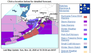
A hurricane force wind warning is a warning issued by the National Weather Service of the United States when sustained winds or frequent gusts of 64 knots or greater are either being observed or are predicted to occur. The winds must not be directly associated with a tropical cyclone, or a hurricane warning will be issued. If winds are lighter than 64 knots, a storm warning or gale warning will be issued. The hurricane force wind warning is only used to warn of the possibility of wind which reaches hurricane-level severity, but lacks direct connection with a hurricane system. The hurricane force wind can either signal sustained winds of 64 knots, or gusts of 64 knots lasting for two or more hours.
A wind advisory is generally issued by the National Weather Service of the United States when there are sustained non-thunderstorm winds of 31–39 miles per hour (50–63 km/h) and/or gusts of 46–57 miles per hour (74–92 km/h) over land. Winds over the said cap will trigger high wind alerts rather than an advisory. The advisory is site specific, but winds of this magnitude occurring over an area that frequently experiences such wind speeds will not trigger a wind advisory.
References
- ↑ National Weather Service. "Hazardous Seas Watch". Glossary - National Weather Service. Retrieved 20 May 2011.
- ↑ National Weather Service. "Hazardous Seas Watch". Iowa Environmental Mesonet NWS Product Archive. Retrieved 20 May 2011.