Related Research Articles

Freezing rain is rain maintained at temperatures below freezing by the ambient air mass that causes freezing on contact with surfaces. Unlike a mixture of rain and snow or ice pellets, freezing rain is made entirely of liquid droplets. The raindrops become supercooled while passing through a sub-freezing layer of air hundreds of meters above the ground, and then freeze upon impact with any surface they encounter, including the ground, trees, electrical wires, aircraft, and automobiles. The resulting ice, called glaze ice, can accumulate to a thickness of several centimeters and cover all exposed surfaces. The METAR code for freezing rain is FZRA.
A winter storm warning is a hazardous weather statement issued by Weather Forecast Offices (WFO) of the National Weather Service (NWS) in the United States to alert the public that a winter storm is occurring or is about to occur in the area, usually within 36 hours of the storm's onset.
A winter weather advisory is a hazardous weather statement issued by Weather Forecast Offices (WFO) of the National Weather Service in the United States when one or more types of winter precipitation—snow, rain and snow mixed, freezing rain, sleet, graupel, etc.—presenting a hazard, but not expected to produce accumulations meeting storm warning criteria, are forecast within 36 hours of the expected onset of precipitation or are occurring in the advisory's coverage area.
A blowing snow advisory was issued by the National Weather Service of the United States when wind driven snow reduces surface visibility and possibly hampers traveling. Blowing snow may be falling snow, or snow that has already accumulated but is picked up and blown by strong winds. This advisory was discontinued beginning with the 2008–09 winter storm season, replaced by the winter weather advisory for snow and blowing snow. However, if the storm is judged to be dangerous by local forecasters, a winter storm warning for heavy snow and blowing snow may be issued.
A winter storm watch is issued by the National Weather Service of the United States when there is a possibility of heavy snow or potential of significant ice accumulations, without meeting a specific other winter criteria. The watch is typically issued 12 to 48 hours before the storm's expected arrival in the given area. The criteria for this watch can vary from place to place, which is true with other winter weather warning and advisories.
A lake effect snow advisory was issued by the National Weather Service of the United States when lake effect snow may pose a hazard or is life-threatening. The snow must be completely caused by a convective snow development over a lake and not by a low pressure system. The criteria for this advisory vary from area to area.
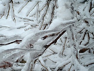
An ice storm warning is a hazardous weather statement issued by the Weather Forecast Offices of the National Weather Service in the United States which indicates that freezing rain produces a significant and possibly damaging accumulation of ice on surfaces. The criteria for this warning vary from state to state, but typically an ice storm warning will be issued any time more than 1⁄4 inch (6.4 mm) of ice at peak is expected to accumulate in an area, else a freezing rain or drizzle advisory is issued; in some areas, the criterion is 1⁄2 inch (13 mm) instead.
A heavy snow warning was a hazardous weather statement issued by the Weather Forecast Offices of the National Weather Service (NWS) in the United States which indicates a high rate of snowfall was occurring or was forecast to occur. Generally, the warning was issued for snowfall rates of 6 inches (15 cm) or more in 12 hours, or 8 inches (20 cm) or more in 24 hours.
This article describes severe weather terminology used by the National Weather Service (NWS) in the United States. The NWS, a government agency operating as an arm of the National Oceanic and Atmospheric Administration (NOAA) branch of the United States Department of Commerce (DoC), defines precise meanings for nearly all of its weather terms.
Freezing drizzle is drizzle that freezes on contact with the ground or an object at or near the surface. Its METAR code is FZDZ.
This article describes severe weather terminology used by the Meteorological Service of Canada, a branch within Environment and Climate Change Canada. The article primarily describes various weather warnings, and their criteria. Related weather scales and general weather terms are also addressed in this article. Some terms are specific to certain regions.

It is very rare for snow to fall in the U.S. state of Florida, especially in the central and southern portions of the state. With the exception of the far northern areas of the state, most of the major cities in Florida have never recorded measurable snowfall, though trace amounts have been recorded, or flurries in the air observed few times each century. According to the National Weather Service, in the Florida Keys and Key West there is no known occurrence of snow flurries since the European colonization of the region more than 300 years ago. In Miami, Fort Lauderdale, and Palm Beach there has been only one known report of snow flurries observed in the air in more than 200 years; this occurred in January 1977. In any event, Miami, Fort Lauderdale, and Palm Beach have not seen snow flurries before or since this 1977 event.
In weather forecasting in the United States, "particularly dangerous situation" (PDS) is enhanced wording used by the National Weather Service to convey special urgency in some watch or warning messages when there is a significant risk of extreme weather, most commonly from types of weather events that are usually less severe by comparison, such as a severe thunderstorm outbreak or flash flooding. It is used in the format "This is a particularly dangerous situation..." at the discretion of the issuing forecaster. A watch or warning bearing the phrase is referred to as a PDS watch or PDS warning as shorthand jargon.
In National Weather Service (NWS) terminology, a Hazardous Weather Outlook is a weather statement issued to provide information of potential severe weather events within the next seven days. The outlook may include information about potential severe thunderstorms, heavy rain or flooding, winter weather, extremes temperatures.
A lake effect snow watch was a bulletin issued by the National Weather Service in the United States to warn of heavy snowfall amounts that will be possible from convective snow generated by cold air masses passing over unfrozen lakes. The criteria for amounts may vary over different county warning areas.
A lake wind advisory is issued by the United States National Weather Service local forecast offices when windy conditions on area lakes are expected to be hazardous for boaters and other recreational events on or around lakes.
A wind chill warning is a hazardous weather statement issued by local forecast offices of the National Weather Service (NWS) in the United States and previously by the Meteorological Service of Environment and Climate Change Canada (ECCC) when wind chills are forecast to reach values low enough for residents and travelers to be susceptible to life-threatening medical conditions or death associated with accelerated body heat loss.
A Heavy Freezing Spray Warning is issued by the National Weather Service of the United States to warn vessels that rapid accumulation and icing of freezing water droplets due to a combination of cold water, wind, cold air, and vessel or vehicle movement is likely. Accumulation rates of 2 cm per hour or greater must be possible for a warning to be issued, or else a freezing spray advisory would be issued.
A Freezing Spray Advisory is issued by the National Weather Service of the United States to warn sea vessels and sometimes road vehicles near the shoreline that accumulation of freezing water droplets and icing due to a combination of cold suspended droplets, wind, and cold air, so vessel movement is possible, however, accumulations are not expected to reach rates of 2 cm per hour, or else a heavy freezing spray watch, warning or a specific notice would be issued.
An Ashfall advisory is a weather advisory issued by the National Weather Service of the United States. Ashfall advisories are issued when there is a likely future or present occurrence of ash rain caused by a large plume of suspended airborne ash, typically caused by large fires or volcanic activity. The National Weather service map color is Dark Grey.
References
- ↑ National Weather Service
- ↑ National Weather Service Hazard Simplification – Retrieved 8 November 2017
- ↑ Watches, Warnings & Advisories (NWS)