
Hurricane Agnes was the costliest hurricane to hit the United States at the time, causing an estimated $2.1 billion in damage. The hurricane's death toll was 128. The effects of Agnes were widespread, from the Caribbean to Canada, with much of the east coast of the United States affected. Damage was heaviest in Pennsylvania, where Agnes was the state's wettest tropical cyclone. Due to the significant effects, the name Agnes was retired in the spring of 1973.
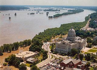
The Great Flood of 1993 was a flood that occurred in the Midwestern United States, along the Mississippi and Missouri rivers and their tributaries, from April to October 1993.

A gale warning is an alert issued by national weather forecasting agencies around the world in an event that maritime locations currently or imminently experiencing winds of gale force on the Beaufort scale. Gale warnings allow mariners to take precautionary actions to ensure their safety at sea or to seek safe anchorage and ride out the storm on land. Though usually associated with deep low-pressure areas, winds strong enough to catalyze a gale warning can occur in other conditions too, including from anticyclones, or high-pressure systems, in the continental interior. The winds are not directly associated with a tropical cyclone.

Noonday Creek is a 20.2-mile-long (32.5 km) stream in Cobb and Cherokee counties in the U.S. state of Georgia. The stream begins near Kennesaw Mountain and ends at Lake Allatoona.
The Suwannee Canal was an attempt to drain large portions of the Okefenokee Swamp in Georgia via a canal. The spelling of the Suwannee River has changed over time. The single n variant was more common in the past, but the double n spelling is the standard today.

Tropical Storm Alberto was the first tropical storm of the 2006 Atlantic hurricane season. Forming on June 10 in the northwestern Caribbean, the storm moved generally to the north, reaching a maximum intensity of 70 mph (110 km/h) before weakening and moving ashore in the Big Bend area of Florida on June 13. Alberto then moved through eastern Georgia, North Carolina, and Virginia as a tropical depression before becoming extratropical on June 14.

A flash flood warning is a severe weather warning product of the National Weather Service that is issued by national weather forecasting agencies throughout the world to alert the public that a flash flood is imminent or occurring in the warned area. A flash flood is a sudden, violent flood after a heavy rain, or occasionally after a dam break. Rainfall intensity and duration, topography, soil conditions, and ground cover contribute to flash flooding.
In weather forecasting in the United States, "particularly dangerous situation" (PDS) is enhanced wording used by the National Weather Service to convey special urgency in some watch or warning messages when there is a significant risk of extreme weather, most commonly from types of weather events that are usually less severe by comparison, such as a severe thunderstorm outbreak or flash flooding. It is used in the format "This is a particularly dangerous situation..." at the discretion of the issuing forecaster. A watch or warning bearing the phrase is referred to as a PDS watch or PDS warning as shorthand jargon.
A flash flood watch is severe weather watch product of the National Weather Service that is issued when conditions are favorable for flash flooding in flood-prone areas, usually when grounds are already saturated from recent rains, or when upcoming rains will have the potential to cause a flash flood. These watches are also occasionally issued when a dam may break in the near future.
A flood warning is closely linked to the task of flood forecasting. The distinction between the two is that the outcome of flood forecasting is a set of forecast time-profiles of channel flows or river levels at various locations, while "flood warning" is the task of making use of these forecasts to make decisions about whether warnings of floods should be issued to the general public or whether previous warnings should be rescinded or retracted.
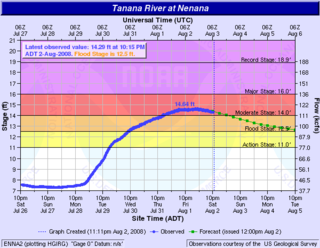
The 2008 Tanana Valley flood or the 2008 Fairbanks flood was a flood in late July and early August 2008 that affected several rivers in the central portion of the American state of Alaska. The city of Fairbanks, Alaska saw high water levels, while the towns of Nenana, Salcha, and Old Minto received heavy damage. The Salcha River and Tanana River reached their second-highest levels since record-keeping began, while the Chena River, which bisects Fairbanks, was kept below flood stage by the use of the Chena River Lakes Flood Control Project.

The 2009 Red River flood along the Red River of the North in North Dakota and Minnesota in the United States and Manitoba in Canada brought record flood levels to the Fargo-Moorhead area. The flood was a result of saturated and frozen ground, spring snowmelt exacerbated by additional rain and snow storms, and virtually flat terrain. Communities along the Red River prepared for more than a week as the U.S. National Weather Service continuously updated the predictions for the city of Fargo, North Dakota, with an increasingly higher projected river crest. Originally predicted to reach a level of near 43 feet (13 m) at Fargo by March 29, the river in fact crested at 40.84 feet (12.45 m) at 12:15 a.m. March 28, and started a slow decline. The river continued to rise to the north as the crest moved downstream.
The US State of North Dakota experienced significant flooding in its major river basins in 2009, following abnormally heavy winter snows atop saturated and frozen ground.
An urban and small stream flood advisory is issued when ponding of water of streets, low-lying areas, highways, underpasses, urban storm drains, and elevation of creek and small stream levels is occurring or imminent. Urban and small stream flood advisories are issued for flooding that occurs within three hours after the excessive rainfall. These advisories are issued on a county by county basis by the local Weather Forecast Office and are generally in effect for 3 to 4 hours.
A river flood watch is issued by the National Weather Service of the United States when flooding at formal forecast points with river gaging sites and established flood stages is possible. Flooding may be caused by various reasons, such as heavy rain in the vicinity of the river, melting snow, and/or ice jams.
A river flood advisory is issued by the National Weather Service of the United States when minor flooding at formal forecast points with river gaging sites and established flood stages is possible. Flooding may have many causes, such as heavy rain in the vicinity of the river, melting snow or ice jams.
A Hazardous Seas Warning is issued by the National Weather Service of the United States when wave heights and/or wave steepness values reach certain criteria. These criteria are defined by the local forecast office. Such tall waves can pose a serious threat to vessels that do not seek shelter.

Tropical Storm Debby was a tropical cyclone that caused extensive flooding in North Florida and Central Florida during late June 2012. The fourth tropical cyclone and named storm of the 2012 Atlantic hurricane season, Debby developed from a trough of low pressure in the central Gulf of Mexico on June 23. The formation of Debby marked the earliest formation on record of the fourth named storm within the Atlantic basin until this record was beaten by Tropical Storm Danielle in 2016. Despite a projected track toward landfall in Louisiana or Texas, the storm headed the opposite direction, moving slowly north-northeast and northeastward. The storm slowly strengthened, and at 1800 UTC on June 25, attained its peak intensity with maximum sustained winds of 65 mph (100 km/h). Dry air, westerly wind shear, and upwelling of cold waters prevented further intensification over the next 24 hours. Instead, Debby weakened, and by late on June 26, it was a minimal tropical storm. At 2100 UTC, the storm made landfall near Steinhatchee, Florida with winds of 40 mph (65 km/h). Once inland, the system continued to weaken while crossing Florida, and dissipated shortly after emerging into the Atlantic on June 27.
A hurricane local statement (HLS) is a weather statement produced for the public by the local Weather Forecast Offices of the National Weather Service in the U.S. for areas affected or forecast to be affected by a tropical storm or hurricane that provides an overview of the storm's local effects, including expected weather conditions, evacuation decisions made by local officials, and precautions necessary to protect life and property. The National Weather Services considers the HLS to be the "flagship product" available to Weather Forecast Offices for outlining tropical cyclone watches and warnings and impacts, and is their most visible product during such events. Descriptions of the affected areas, relevant tropical cyclone watches and warnings, recommendations for precautionary measures, and expected timing and severity of possible threats are typically included in an HLS. The HLS can incorporate projected impacts from pre-written descriptions tailored for different storm intensities; these template descriptions were developed in the 1990s and became widely available to forecasters for use in the HLS by 2001. The bulletin issued by the Weather Forecast Office in Slidell, Louisiana, as Hurricane Katrina approached on August 28, 2005, known as "The Bulletin", was lauded by the National Weather Service as having further encouraged vulnerable individuals to evacuate. Not all forecast offices can issue an HLS.
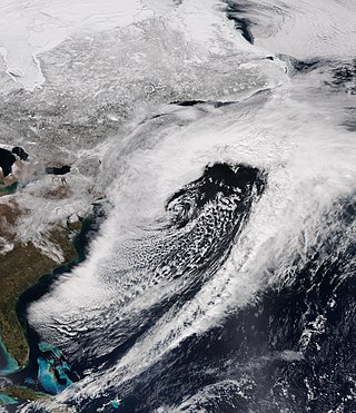
The March 20–22, 2018 nor'easter, dubbed the "Four'easter" in some media outlets, brought additional significant late-season snowfall to the Northeastern United States, after three previous such nor'easters had struck the general region on March 1–3, 6–8, and 12–15, respectively. affected the Mid-Atlantic states and New England with over 18 in (46 cm) of heavy snow and whiteout conditions. It also affected areas of the Southeastern and Midwestern United States with both snowfall and severe weather. The nor'easter was also one of the heaviest spring snowstorms on record in some areas in the Mid-Atlantic, especially Philadelphia and New York City.