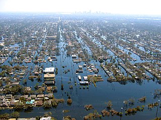
A flash flood watch (SAME code: FFA; also referred as a "green box" by meteorologists) is severe weather watch product of the National Weather Service that is issued when conditions are favorable for flash flooding in flood-prone areas, usually when grounds are already saturated from recent rains, or when upcoming rains will have the potential to cause a flash flood. These watches are also occasionally issued when a dam may break in the near future.[1]
688 WGUS61 KPHI 071932 FFAPHI URGENT - IMMEDIATE BROADCAST REQUESTED Flood Watch National Weather Service Mount Holly NJ 332 PM EDT Wed Jul 7 2021 NJZ001-007-PAZ054-055-060>062-080745- /O.NEW.KPHI.FF.A.0003.210708T1600Z-210709T1600Z/ /00000.0.ER.000000T0000Z.000000T0000Z.000000T0000Z.OO/ Sussex-Warren-Carbon-Monroe-Berks-Lehigh-Northampton- Including the cities of Jim Thorpe, Allentown, Newton, Washington, Bethlehem, Stroudsburg, Reading, and Easton 332 PM EDT Wed Jul 7 2021 ...FLASH FLOOD WATCH IN EFFECT FROM THURSDAY AFTERNOON THROUGH FRIDAY MORNING... The National Weather Service in Mount Holly has issued a * Flash Flood Watch for portions of northern New Jersey...and Pennsylvania...including the following areas...in northern New Jersey...Sussex and Warren. In Pennsylvania...Berks, Carbon, Lehigh, Monroe, and Northampton. * From Thursday afternoon through Friday morning. * Heavy rainfall will develop over portions of eastern PA and NW New Jersey ahead of Tropical Storm Elsa Thursday afternoon. The heavy rains will see 1 to 2 inches with locally higher amounts and then will see another 1 to 2 inches with the heavy rainfall associated with Tropical Storm Elsa Thursday evening through the overnight hours. * Heavy rain in short periods of time will cause the potential for streams and creeks to quickly rise out of their banks as well as the potential for flash flooding in areas of poor drainage. $$ DEZ001>004-MDZ012-015-019-020-NJZ008>010-012>027-PAZ070-071-101>106- 080745- /O.NEW.KPHI.FF.A.0003.210708T2100Z-210709T1600Z/ /00000.0.ER.000000T0000Z.000000T0000Z.000000T0000Z.OO/ New Castle-Kent-Inland Sussex-Delaware Beaches-Kent MD-Queen Annes- Talbot-Caroline-Morris-Hunterdon-Somerset-Middlesex-Western Monmouth- Eastern Monmouth-Mercer-Salem-Gloucester-Camden-Northwestern Burlington-Ocean-Cumberland-Atlantic-Cape May-Atlantic Coastal Cape May-Coastal Atlantic-Coastal Ocean-Southeastern Burlington-Delaware- Philadelphia-Western Chester-Eastern Chester-Western Montgomery- Eastern Montgomery-Upper Bucks-Lower Bucks- Including the cities of Glassboro, Denton, Jackson, Flemington, Media, Philadelphia, Doylestown, Chalfont, Morristown, Pennsville, Honey Brook, Centreville, Norristown, Georgetown, Mount Holly, Ocean City, Cherry Hill, Moorestown, Freehold, Pottstown, Hammonton, Cape May Court House, Oxford, Kennett Square, Sandy Hook, Chestertown, Morrisville, West Chester, Millville, Wilmington, New Brunswick, Dover, Trenton, Lansdale, Wharton State Forest, Atlantic City, Collegeville, Long Beach Island, Camden, Easton, Perkasie, Rehoboth Beach, and Somerville 332 PM EDT Wed Jul 7 2021 ...FLASH FLOOD WATCH IN EFFECT FROM THURSDAY AFTERNOON THROUGH FRIDAY MORNING... The National Weather Service in Mount Holly has issued a * Flash Flood Watch for portions of Delaware...northeast Maryland... New Jersey...and southeast Pennsylvania...including the following areas...in Delaware...Delaware Beaches, Inland Sussex, Kent, and New Castle. In northeast Maryland...Caroline, Kent MD, Queen Annes, and Talbot. In New Jersey...Atlantic, Atlantic Coastal Cape May, Camden, Cape May, Coastal Atlantic, Coastal Ocean, Cumberland, Eastern Monmouth, Gloucester, Hunterdon, Mercer, Middlesex, Morris, Northwestern Burlington, Ocean, Salem, Somerset, Southeastern Burlington, and Western Monmouth. In southeast Pennsylvania...Delaware, Eastern Chester, Eastern Montgomery, Lower Bucks, Philadelphia, Upper Bucks, Western Chester, and Western Montgomery. * From Thursday afternoon through Friday morning. * Tropical Storm Elsa will move across portions of DelMarVa, New Jersey, and eastern PA Thursday night, bringing heavy rainfall to the region. Expected rainfall totals across DelMarVa and New Jersey range from 2 to 3 inches, with locally higher amounts up to 5 inches possible. Further west of the I-95 corridor could expect to see 1-2 inches, with locally higher amounts to 3 inches possible. * Heavy rain in short periods of time will cause the potential for streams and creeks to quickly rise out of their banks as well as the potential for flash flooding in urban areas. $$ Deal
If a flash flood watch is likely to lead to a major flash flood disaster, then enhanced wording with the words This is a particularly dangerous situation (PDS) can be added to the watch; this is occasionally issued. Below is an example issued by the National Weather Service in Memphis, Tennessee.
URGENT - IMMEDIATE BROADCAST REQUESTED FLOOD WATCH NATIONAL WEATHER SERVICE MEMPHIS TN 239 PM CDT SUN APR 24 2011 ...VERY HEAVY RAINFALL THROUGH THE MIDDLE OF THIS WEEK WILL LIKELY LEAD TO SIGNIFICANT...WIDESPREAD FLASH FLOODING... ...THIS IS A PARTICULARLY DANGEROUS SITUATION... A BOUNDARY WILL CONTINUE TO REMAIN STATIONARY ACROSS SOUTHERN MISSOURI INTO KENTUCKY THROUGH MONDAY. REPEATED ROUNDS OF THUNDERSTORMS WILL TRACK ALONG THE FRONT BRINGING HEAVY RAINFALL. THEN A LOW PRESSURE SYSTEM WILL TRACK ALONG IT INTO MISSOURI AND PUSH THE FRONT FURTHER SOUTH TO ALONG THE I-40 CORRIDOR MONDAY NIGHT THROUGH TUESDAY NIGHT. THIS WILL SHIFT THE HEAVY RAIN AXIS FURTHER SOUTH TO ALONG AND JUST NORTH OF THE I-40 CORRIDOR. A SECOND LOW PRESSURE SYSTEM WILL TRACK ALONG THE NEWLY STALLED BOUNDARY AND SET OFF ADDITIONAL TRAINING THUNDERSTORMS LATE TUESDAY NIGHT AND WEDNESDAY. THE FINAL COLD FRONT WILL PASS THROUGH LATE WEDNESDAY AFTERNOON...ENDING THE PERSISTENT HEAVY RAINFALL. ARZ026>028-035-036-048-049-058-MSZ001>014-TNZ003-004-019>021- 048>055-088>092-250400- /O.NEW.KMEG.FF.A.0007.110426T0000Z-110428T0000Z/ /00000.0.ER.000000T0000Z.000000T0000Z.000000T0000Z.OO/ CRAIGHEAD-POINSETT-MISSISSIPPI-CROSS- CRITTENDEN-ST. FRANCIS- LEE AR-PHILLIPS-DESOTO-MARSHALL-BENTON MS-TIPPAH-ALCORN- TISHOMINGO-TUNICA-TATE-PRENTISS- COAHOMA-QUITMAN-PANOLA-LAFAYETTE- UNION-WEAKLEY-HENRY-DYER-GIBSON-CARROLL-LAUDERDALE-TIPTON-HAYWOOD- CROCKETT-MADISON-CHESTER-HENDERSON- DECATUR-SHELBY-FAYETTE- HARDEMAN-MCNAIRY-HARDIN- INCLUDING THE CITIES OF...JONESBORO...HARRISBURG...BLYTHEVILLE... WYNNE...WEST MEMPHIS...FORREST CITY...HELENA... SOUTHAVEN... OLIVE BRANCH...CORINTH...IUKA...TUNICA...[[Booneville, Mississippi|BOONEVILLE]]... CLARKSDALE...BATESVILLE...OXFORD...NEW ALBANY... MARTIN... DRESDEN...PARIS...DYERSBURG...HUMBOLDT...MILAN...HUNTINGDON... COVINGTON...JACKSON...LEXINGTON...BARTLETT...GERMANTOWN... COLLIERVILLE...MEMPHIS...MILLINGTON...SOMERVILLE... BOLIVAR... SAVANNAH 239 PM CDT SUN APR 24 2011 ...FLASH FLOOD WATCH IN EFFECT FROM MONDAY EVENING THROUGH WEDNESDAY EVENING... THE NATIONAL WEATHER SERVICE IN MEMPHIS HAS ISSUED A * FLASH FLOOD WATCH FOR PORTIONS OF EAST ARKANSAS...NORTH MISSISSIPPI AND WEST TENNESSEE...INCLUDING THE FOLLOWING AREAS...IN EAST ARKANSAS...CRAIGHEAD...CRITTENDEN...CROSS... LEE...MISSISSIPPI...PHILLIPS...POINSETT AND ST. FRANCIS. IN NORTH MISSISSIPPI...ALCORN...BENTON...COAHOMA...DESOTO... LAFAYETTE...MARSHALL...PANOLA...PRENTISS...QUITMAN...TATE... TIPPAH...TISHOMINGO...TUNICA AND UNION. IN WEST TENNESSEE... CARROLL...CHESTER...CROCKETT...DECATUR...DYER...FAYETTE... GIBSON...HARDEMAN...HARDIN...HAYWOOD...HENDERSON...HENRY... LAUDERDALE...MADISON...MCNAIRY...SHELBY...TIPTON AND WEAKLEY. * FROM MONDAY EVENING THROUGH WEDNESDAY EVENING. * THIS IS A PARTICULARLY DANGEROUS SITUATION * TOTAL RAINFALL AMOUNTS OF 5 TO 8 INCHES ARE EXPECTED ALONG AND NORTH OF I-40 WITH 2 TO 5 INCHES EXPECTED SOUTH OF I-40. LOCALLY HIGHER AMOUNTS ARE LIKELY. * RAINFALL AMOUNTS SUCH AS THESE MAY LEAD TO WIDESPREAD... SIGNIFICANT...AND LIFE THREATENING FLASH FLOODING. THIS EVENT MAY BE AS SEVERE AS THE MAY 1–2, 2010 FLOODING IN PLACES. FLASH FLOODING OF CITIES...RURAL AREAS...RIVERS...AND SMALL STREAMS ARE POSSIBLE. PRECAUTIONARY/PREPAREDNESS ACTIONS... A FLASH FLOOD WATCH MEANS THAT CONDITIONS MAY DEVELOP THAT LEAD TO FLASH FLOODING. FLASH FLOODING IS A VERY DANGEROUS SITUATION. YOU SHOULD MONITOR LATER FORECASTS AND BE PREPARED TO TAKE ACTION SHOULD FLASH FLOOD WARNINGS BE ISSUED. && $$ ARZ008-009-017-018-MOZ113-115-TNZ001-002-250400- /O.EXT.KMEG.FF.A.0006.000000T0000Z-110428T0000Z/ /00000.0.ER.000000T0000Z.000000T0000Z.000000T0000Z.OO/ RANDOLPH-CLAY-LAWRENCE-GREENE-DUNKLIN-PEMISCOT-LAKE-OBION- INCLUDING THE CITIES OF...WALNUT RIDGE...PARAGOULD...KENNETT... CARUTHERSVILLE...UNION CITY 239 PM CDT SUN APR 24 2011 ...FLASH FLOOD WATCH NOW IN EFFECT THROUGH WEDNESDAY EVENING... THE FLASH FLOOD WATCH IS NOW IN EFFECT FOR * PORTIONS OF EAST ARKANSAS...SOUTHEAST MISSOURI AND WEST TENNESSEE...INCLUDING THE FOLLOWING AREAS...IN EAST ARKANSAS... CLAY...GREENE...LAWRENCE AND RANDOLPH. IN SOUTHEAST MISSOURI... DUNKLIN AND PEMISCOT. IN WEST TENNESSEE...LAKE AND OBION. * THROUGH WEDNESDAY EVENING. * THIS IS A PARTICULARLY DANGEROUS SITUATION * ADDITIONAL RAINFALL AMOUNTS OF 6 TO 9 INCHES ARE EXPECTED. LOCALLY HIGHER AMOUNTS ARE LIKELY. THIS...IN COMBINATION OF THE 2 TO 4 INCHES THAT HAVE ALREADY FALLEN MAY LEAD TO TOTAL RAINFALL AMOUNTS IN EXCESS OF 12 INCHES IN MANY LOCATIONS. * RAINFALL AMOUNTS SUCH AS THESE WILL LIKELY LEAD TO WIDESPREAD... SIGNIFICANT...AND LIFE THREATENING FLASH FLOODING. THIS EVENT MAY BE AS SEVERE AS THE MAY 1-2 2010 FLOODING IN MANY PLACES. FLASH FLOODING OF CITIES...RURAL AREAS...RIVERS...AND SMALL STREAMS ARE POSSIBLE. PRECAUTIONARY/PREPAREDNESS ACTIONS... A FLASH FLOOD WATCH MEANS THAT CONDITIONS MAY DEVELOP THAT LEAD TO FLASH FLOODING. FLASH FLOODING IS A VERY DANGEROUS SITUATION. YOU SHOULD MONITOR LATER FORECASTS AND BE PREPARED TO TAKE ACTION SHOULD FLASH FLOOD WARNINGS BE ISSUED. && $$ BORGHOFF
Hurricane Jeanne was a Category 3 hurricane that struck the Caribbean and the Eastern United States in September 2004. It was the deadliest hurricane in the Atlantic basin since Mitch in 1998. It was the tenth named storm, the seventh hurricane, and the fifth major hurricane of the season, as well as the third hurricane and fourth named storm of the season to make landfall in Florida. After wreaking havoc on Hispaniola, Jeanne struggled to reorganize, eventually strengthening and performing a complete loop over the open Atlantic. It headed westwards, strengthening into a Category 3 hurricane and passing over the islands of Great Abaco and Grand Bahama in the Bahamas on September 25. Jeanne made landfall later in the day in Florida just two miles from where Hurricane Frances had struck a mere three weeks earlier.
This article describes severe weather terminology used by the National Weather Service (NWS) in the United States. The NWS, a government agency operating as an arm of the National Oceanic and Atmospheric Administration (NOAA) branch of the United States Department of Commerce (DoC), defines precise meanings for nearly all of its weather terms.
Tropical Storm Alberto was the first tropical storm of the 2006 Atlantic hurricane season. Forming on June 10 in the northwestern Caribbean, the storm moved generally to the north, reaching a maximum intensity of 70 mph (110 km/h) before weakening and moving ashore in the Big Bend area of Florida on June 13. Alberto then moved through eastern Georgia, North Carolina, and Virginia as a tropical depression before becoming extratropical on June 14.
Tropical Storm Henri was a moderate tropical storm that formed in the 2003 Atlantic hurricane season. The eighth storm of the season, Henri was one of six tropical cyclones to hit the United States in the year. Henri formed from a tropical wave in the Gulf of Mexico in early September, and crossed over Florida as a tropical depression. Its remnants later moved into the Mid-Atlantic before dissipating completely.
A flash flood warning is a severe weather warning product of the National Weather Service that is issued by national weather forecasting agencies throughout the world to alert the public that a flash flood is imminent or occurring in the warned area. A flash flood is a sudden, violent flood after a heavy rain, or occasionally after a dam break. Rainfall intensity and duration, topography, soil conditions, and ground cover contribute to flash flooding.
In weather forecasting in the United States, "particularly dangerous situation" (PDS) is enhanced wording used by the National Weather Service to convey special urgency in some watch or warning messages when there is a significant risk of extreme weather, most commonly from types of weather events that are usually less severe by comparison, such as a severe thunderstorm outbreak or flash flooding. It is used in the format "This is a particularly dangerous situation..." at the discretion of the issuing forecaster. A watch or warning bearing the phrase is referred to as a PDS watch or PDS warning as shorthand jargon.
Floods in the United States (2000–present) is a list of flood events which were of significant impact to the country during the 21st century, since 2000. Floods are generally caused by excessive rainfall, excessive snowmelt, storm surge from hurricanes, and dam failure.
Tropical Storm Barry was a rapidly forming tropical cyclone that made landfall on Florida, United States, in early June 2007. The second named storm of the 2007 Atlantic hurricane season, Barry developed from a trough of low pressure in the southeastern Gulf of Mexico on June 1. It tracked rapidly northeastward, reaching peak winds of 60 mph (97 km/h) before weakening and making landfall near Tampa Bay as a tropical depression. Barry quickly lost tropical characteristics after wind shear removed much of the convection, and early on June 3, it completed the transition into an extratropical cyclone. The extratropical remnants tracked up the East Coast of the United States, and were absorbed by a larger extratropical cyclone on June 5.
A blizzard watch was a bulletin issued by the National Weather Service of the United States which meant winds greater than 35 miles per hour, mixed with falling or blowing snow, and visibilities of 1⁄4 mile (0.4 km) or less is forecast for a period of 3 hours or more. A blizzard watch was issued 12 to 48 hours before an expected blizzard event. As the forecast solidifies, a blizzard watch would be either downgraded to a winter storm warning or winter weather advisory for blowing snow or upgraded to a blizzard warning.
A flood warning is closely linked to the task of flood forecasting. The distinction between the two is that the outcome of flood forecasting is a set of forecast time-profiles of channel flows or river levels at various locations, while "flood warning" is the task of making use of these forecasts to make decisions about whether warnings of floods should be issued to the general public or whether previous warnings should be rescinded or retracted.
The effects of Hurricane Jeanne in the Mid-Atlantic region of the United States included two fatalities and $530 million in damage. Originating from a tropical wave off the coast of Africa in early September 2004, Hurricane Jeanne tracked through the Leeward Islands and Hispaniola for several days, resulting in extensive damage and an immense loss of life. After completing a clockwise loop between September 22 and 24, the storm intensified into a major hurricane before striking the Bahamas and Florida. Substantially weaker, the system turned northeastward over Georgia before affecting Delaware, District of Columbia, Maryland, New Jersey, New York, Pennsylvania, Virginia, and West Virginia; all of those states are in the Mid-Atlantic region of the United States. By the evening of September 26, the Hydrometeorological Prediction Center took over responsibility of monitoring the former hurricane over Virginia.
An urban and small stream flood advisory is issued when ponding of water of streets, low-lying areas, highways, underpasses, urban storm drains, and elevation of creek and small stream levels is occurring or imminent. Urban and small stream flood advisories are issued for flooding that occurs within three hours after the excessive rainfall. These advisories are issued on a county by county basis by the local Weather Forecast Office and are generally in effect for 3 to 4 hours.
A river flood warning is issued by the National Weather Service of the United States when forecast points with formal river gaging sites and established flood stages along rivers, where flooding has already been forecast, is imminent or occurring. The National Weather Service defines river flooding as "the inundation of normally dry areas as a result of increased water levels in an established water course."
A river flood watch is issued by the National Weather Service of the United States when flooding at formal forecast points with river gaging sites and established flood stages is possible. Flooding may be caused by various reasons, such as heavy rain in the vicinity of the river, melting snow, and/or ice jams.
Tropical Storm Andrea brought flooding to Cuba, the Yucatan Peninsula, and portions of the East Coast of the United States in June 2013. The first tropical cyclone and named storm of the annual hurricane season, Andrea originated from an area of low pressure in the eastern Gulf of Mexico on June 5. Despite strong wind shear and an abundance of dry air, the storm strengthened while initially heading north-northeastward. Later on June 5, it re-curved northeastward and approached the Big Bend region of Florida. Andrea intensified and peaked as a strong tropical storm with winds at 65 mph (105 km/h) on June 6. A few hours later, the storm weakened slightly and made landfall near Steinhatchee, Florida later that day. It began losing tropical characteristics while tracking across Florida and Georgia. Andrea transitioned into an extratropical cyclone over South Carolina on June 7, though the remnants continued to move along the East Coast of the United States, until being absorbed by another extratropical system offshore Maine on June 10.
The January 2018 American West floods occurred due to heavy precipitation in the Western United States. While wildfires in Southern California exacerbated the rain's effects there, other states, like Nevada, also experienced flooding.
On the morning and into the early afternoon of June 3, 2020, a powerful derecho crossed the U.S. states of Pennsylvania and New Jersey, resulting in four fatalities. It was the deadliest derecho event in the region since 1950.
Tropical Storm Fay was the first tropical cyclone to make landfall in the U.S state of New Jersey since Hurricane Irene in 2011. The sixth named storm of the very active 2020 Atlantic hurricane season, Fay was the earliest sixth named storm on record in the basin when it formed on July 9. Fay originated from a surface low that formed over the Northern Gulf of Mexico on July 3 and slowly drifted eastward, before crossing over the Florida Panhandle. The system subsequently drifted across the Southeastern United States as a well-defined low pressure system, before emerging off the coast of North Carolina on July 8. From there, the storm utilized favorable conditions for development, or tropical cyclogenesis, and coalesced into a tropical storm on July 9. The storm intensified, reaching its peak intensity on July 10, with maximum 1-minute sustained winds of 60 mph (97 km/h) and a minimum central pressure of 998 millibars (29.5 inHg). While moving northward, Fay made landfall on New Jersey later that day. After making landfall, the storm quickly lost most of its organization and rapidly transitioned into a post-tropical cyclone over New York on July 11, before being absorbed by a larger extratropical low over Quebec on July 12.
This page is based on this Wikipedia article Text is available under the CC BY-SA 4.0 license; additional terms may apply. Images, videos and audio are available under their respective licenses.