Related Research Articles
Flood alerts are issued by weather agencies to alert residents that flood conditions are a possibility.

The Weather Prediction Center (WPC), located in College Park, Maryland, is one of nine service centers under the umbrella of the National Centers for Environmental Prediction (NCEP), a part of the National Weather Service (NWS), which in turn is part of the National Oceanic and Atmospheric Administration (NOAA) of the U.S. Government. Until March 5, 2013 the Weather Prediction Center was known as the Hydrometeorological Prediction Center (HPC). The Weather Prediction Center serves as a center for quantitative precipitation forecasting, medium range forecasting, and the interpretation of numerical weather prediction computer models.
A blowing snow advisory was issued by the National Weather Service of the United States when wind driven snow reduces surface visibility and possibly hampers traveling. Blowing snow may be falling snow, or snow that has already accumulated but is picked up and blown by strong winds. This advisory was discontinued beginning with the 2008–09 winter storm season, replaced by the winter weather advisory for snow and blowing snow. However, if the storm is judged to be dangerous by local forecasters, a winter storm warning for heavy snow and blowing snow may be issued.
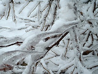
An ice storm warning is a hazardous weather statement issued by the Weather Forecast Offices of the National Weather Service in the United States which indicates that freezing rain produces a significant and possibly damaging accumulation of ice on surfaces. The criteria for this warning vary from state to state, but typically an ice storm warning will be issued any time more than 1⁄4 inch (6.4 mm) of ice at peak is expected to accumulate in an area, else a freezing rain or drizzle advisory is issued; in some areas, the criterion is 1⁄2 inch (13 mm) instead.

At sea, a storm warning is a warning issued by the National Weather Service of the United States when winds between 48 knots and 63 knots are occurring or predicted to occur soon. The winds must not be associated with a tropical cyclone. If the winds are associated with a tropical cyclone, a tropical storm warning will be substituted for the storm warning and less severe gale warning.

This article describes severe weather terminology used by the National Weather Service (NWS) in the United States. The NWS, a government agency operating as an arm of the National Oceanic and Atmospheric Administration (NOAA) branch of the United States Department of Commerce (DoC), defines precise meanings for nearly all of its weather terms.

A flash flood warning is a severe weather warning product of the National Weather Service that is issued by national weather forecasting agencies throughout the world to alert the public that a flash flood is imminent or occurring in the warned area. A flash flood is a sudden, violent flood after a heavy rain, or occasionally after a dam break. Rainfall intensity and duration, topography, soil conditions, and ground cover contribute to flash flooding.
In weather forecasting in the United States, "particularly dangerous situation" (PDS) is enhanced wording used by the National Weather Service to convey special urgency in some watch or warning messages when there is a significant risk of extreme weather, most commonly from types of weather events that are usually less severe by comparison, such as a severe thunderstorm outbreak or flash flooding. It is used in the format "This is a particularly dangerous situation..." at the discretion of the issuing forecaster. A watch or warning bearing the phrase is referred to as a PDS watch or PDS warning as shorthand jargon.
A flash flood watch is severe weather watch product of the National Weather Service that is issued when conditions are favorable for flash flooding in flood-prone areas, usually when grounds are already saturated from recent rains, or when upcoming rains will have the potential to cause a flash flood. These watches are also occasionally issued when a dam may break in the near future.

The Great Coastal Storm of 2007 was a series of three powerful Pacific storms that affected the U.S. states of Oregon and Washington and the Canadian province of British Columbia between December 1, 2007 and December 4, 2007.
A flood warning is closely linked to the task of flood forecasting. The distinction between the two is that the outcome of flood forecasting is a set of forecast time-profiles of channel flows or river levels at various locations, while "flood warning" is the task of making use of these forecasts to make decisions about whether warnings of floods should be issued to the general public or whether previous warnings should be rescinded or retracted.
A freeze warning is a warning issued by the National Weather Service when sub-freezing temperatures are expected in the next 36 hours. This can occur with or without frost. When a freeze warning is issued in the fall, that will usually signify the end of the growing season, as sub-freezing temperatures will usually kill all remaining crops. Farmers and gardeners should take action to protect or harvest their herbaceous plants if a freeze warning is issued. A freeze warning is issued several hours after a freeze watch if a freeze continues to be expected.
A lake effect snow watch was a bulletin issued by the National Weather Service in the United States to warn of heavy snowfall amounts that will be possible from convective snow generated by cold air masses passing over unfrozen lakes. The criteria for amounts may vary over different county warning areas.
An urban and small stream flood advisory is issued when ponding of water of streets, low-lying areas, highways, underpasses, urban storm drains, and elevation of creek and small stream levels is occurring or imminent. Urban and small stream flood advisories are issued for flooding that occurs within three hours after the excessive rainfall. These advisories are issued on a county by county basis by the local Weather Forecast Office and are generally in effect for 3 to 4 hours.
A river flood warning is issued by the National Weather Service of the United States when forecast points with formal river gaging sites and established flood stages along rivers, where flooding has already been forecast, is imminent or occurring. The National Weather Service defines river flooding as "the inundation of normally dry areas as a result of increased water levels in an established water course."
A river flood advisory is issued by the National Weather Service of the United States when minor flooding at formal forecast points with river gaging sites and established flood stages is possible. Flooding may have many causes, such as heavy rain in the vicinity of the river, melting snow or ice jams.
A Heavy Freezing Spray Warning is issued by the National Weather Service of the United States to warn vessels that rapid accumulation and icing of freezing water droplets due to a combination of cold water, wind, cold air, and vessel or vehicle movement is likely. Accumulation rates of 2 cm per hour or greater must be possible for a warning to be issued, or else a freezing spray advisory would be issued.
A Freezing Spray Advisory is issued by the National Weather Service of the United States to warn sea vessels and sometimes road vehicles near the shoreline that accumulation of freezing water droplets and icing due to a combination of cold suspended droplets, wind, and cold air, so vessel movement is possible, however, accumulations are not expected to reach rates of 2 cm per hour, or else a heavy freezing spray watch, warning or a specific notice would be issued.

Mount Skokomish is a 6,434 ft mountain summit located in the Olympic Mountains, in Mason County of Washington state. It is situated on the shared boundary of Olympic National Park with Mount Skokomish Wilderness, and is the highest point of the wilderness. Its nearest higher peak is Mount Stone, 1.66 mi (2.67 km) to the northeast. It is visible on the Olympic skyline from as far away as Seattle. Mt. Skokomish has three summits, the south peak being the highest. Precipitation runoff drains into the Hamma Hamma River and Skokomish River. Like the river, the mountain's name honors the Skokomish people.
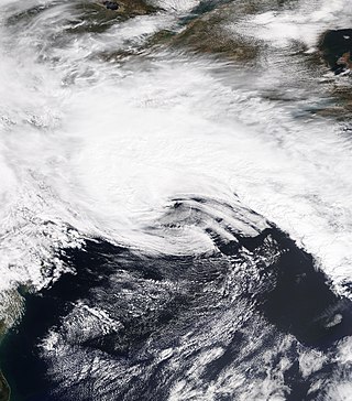
The April 2021 nor'easter, also referred to as the 2021 Spring nor'easter, was a significant late-season nor'easter that impacted much of New England with heavy snowfall, gusty winds, thundersnow, and near-whiteout conditions from April 15–17, 2021. The system originated from a weak frontal system late on April 14 over North Carolina, which moved into the ocean the next day and began to strengthen. The low-pressure steadily deepened as it moved up the East Coast, and developed an eye-like feature just prior to peak intensity. It prompted a fairly large area of Winter Storm Warnings across interior sections of New England, with Winter Weather Advisories being issued closer to the coast. Over 20,000 customers lost power at the height of the storm on April 16 due to heavy wet snow, and near-whiteout conditions were reported in many areas. Several injuries, some serious, occurred as well, mostly due to traffic incidents on poorly-treated roadways during the storm. Damage estimates from the system are currently not calculated.
References
- ↑ Baltimore/Washington National Weather Service Forecast Office. "River Flood Watch". Definitions of Weather Watch, Warnings and Advisories. Retrieved 17 May 2011.
- ↑ Seattle National Weather Service Forecast Office. "River Flood Watch (FFA)" (PDF). Appendix H – Product Examples – Watches, Warnings, Advisories, and Statements. Retrieved 17 May 2011.