The Beaufort scale is an empirical measure that relates wind speed to observed conditions at sea or on land. Its full name is the Beaufort wind force scale.

A tornado watch is a severe weather watch product of the National Weather Service that is issued by national weather forecasting agencies when meteorological conditions are favorable for the development of severe thunderstorms capable of producing tornadoes. In addition to the potential for tornado development, thunderstorms that develop within the watch area may contain large hail, straight-line winds, intense rainfall and/or flooding that pose a similar damage risk as the attendant tornado threat. A tornado watch does not mean a tornado is active or will appear, just that favorable conditions increases the likelihood of such happening. A watch must not be confused with a tornado warning.

A severe thunderstorm watch is a severe weather watch product of the National Weather Service that is issued by regional offices of weather forecasting agencies throughout the world when meteorological conditions are favorable for the development of severe thunderstorms as defined by regional criteria that may contain large hail, straight-line winds, lightning, intense hydrological phenomena and/or tornadoes. A severe thunderstorm watch does not necessarily mean that severe weather is actually occurring, only that conditions present a credible risk for thunderstorms producing severe weather phenomena to affect portions of the watch area. A watch must not be confused with a severe thunderstorm warning.

A small craft advisory is a type of wind warning issued by the National Weather Service in the United States. In Canada a similar warning is issued by Environment Canada. It is issued when winds have reached, or are expected to reach within 12 hours, a speed marginally less than gale force. A Small Craft Advisory may also be issued when sea or lake ice exists that could be hazardous to small boats.

The great storm of 1987 was a violent extratropical cyclone that occurred on the night of 15–16 October, with hurricane-force winds causing casualties in the United Kingdom, France, and the Channel Islands as a severe depression in the Bay of Biscay moved northeast. Among the most damaged areas were Greater London, the East Anglian coast, the Home Counties, the west of Brittany, and the Cotentin Peninsula of Normandy, all of which weathered gusts typically with a return period of 1 in 200 years.

Tropical cyclone warnings and watches are alerts issued by national weather forecasting bodies to coastal areas threatened by the imminent approach of a tropical cyclone of tropical storm or hurricane intensity. They are notices to the local population and civil authorities to make appropriate preparation for the cyclone, including evacuation of vulnerable areas where necessary. It is important that interests throughout the area of an alert make preparations to protect life and property, and do not disregard it on the strength of the detailed forecast track.
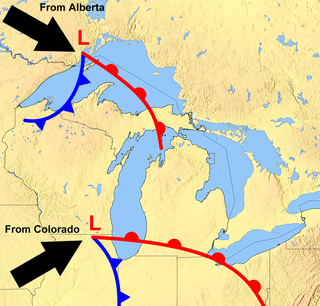
The Great Lakes Storm of 1913 was a blizzard with hurricane-force winds that devastated the Great Lakes Basin in the Midwestern United States and Southwestern Ontario, Canada, from November 7 to 10, 1913. The storm was most powerful on November 9, battering and overturning ships on four of the five Great Lakes, particularly Lake Huron.

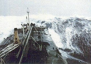
A gale warning is an alert issued by national weather forecasting agencies around the world in an event that maritime locations currently or imminently experiencing winds of gale force on the Beaufort scale. Gale warnings allow mariners to take precautionary actions to ensure their safety at sea or to seek safe anchorage and ride out the storm on land. Though usually associated with deep low-pressure areas, winds strong enough to catalyze a gale warning can occur in other conditions too, including from anticyclones, or high-pressure systems, in the continental interior. The winds are not directly associated with a tropical cyclone.

At sea, a storm warning is a warning issued by the National Weather Service of the United States when winds between 48 knots and 63 knots are occurring or predicted to occur soon. The winds must not be associated with a tropical cyclone. If the winds are associated with a tropical cyclone, a tropical storm warning will be substituted for the storm warning and less severe gale warning.

This article describes severe weather terminology used by the National Weather Service (NWS) in the United States. The NWS, a government agency operating as an arm of the National Oceanic and Atmospheric Administration (NOAA) branch of the United States Department of Commerce (DoC), defines precise meanings for nearly all of its weather terms.
Tropical cyclones are ranked on one of five tropical cyclone intensity scales, according to their maximum sustained winds and which tropical cyclone basins they are located in. Only a few scales of classifications are used officially by the meteorological agencies monitoring the tropical cyclones, but other scales also exist, such as accumulated cyclone energy, the Power Dissipation Index, the Integrated Kinetic Energy Index, and the Hurricane Severity Index.

Hurricane Esther was the first large tropical cyclone to be discovered by satellite imagery. The fifth tropical cyclone, named storm, and hurricane of the 1961 Atlantic hurricane season, Esther developed from an area of disturbed weather hundreds of miles west-southwest of the southernmost Cape Verde Islands on September 10. Moving northwestward, the depression strengthened into Tropical Storm Esther on September 11, before reaching hurricane intensity on the following day. Early on September 13, Esther curved westward and deepened into a major hurricane. The storm remained a Category 3 hurricane for about four days and gradually moved in a west-northwestward direction. Late on September 17, Esther strengthened into a Category 5 hurricane with sustained winds of 160 mph (260 km/h) on September 18. The storm curved north-northeastward on September 19, while offshore of North Carolina. Esther began to weaken while approaching New England and fell to Category 3 intensity on September 21. The storm turned eastward early on the following day, and rapidly weakened to a tropical storm.

Hurricane Karen was a hurricane of non-tropical origin that formed in October of the 2001 Atlantic hurricane season. It developed out of the interaction between a cold front and an upper level trough on October 10 located to the south of Bermuda, and quickly strengthened as an extratropical storm. The storm passed near Bermuda on October 12, producing hurricane-force winds on the island. It then organized, becoming a subtropical cyclone on the 12th and a tropical cyclone on the 13th. Karen strengthened to reach 80 mph (130 km/h) winds as a Category 1 hurricane on the Saffir-Simpson Hurricane Scale, and after weakening over cooler waters, it made landfall on Nova Scotia as a tropical storm. It quickly became extratropical.
A particularly dangerous situation (PDS) tag is enhanced wording first used by the Storm Prediction Center (SPC), a national guidance center of the United States National Weather Service, for tornado watches and eventually expanded to use for other severe weather watches and warnings by local NWS forecast offices. It is issued at the discretion of the forecaster composing the watch or warning and implies that there is an enhanced risk of very severe and life-threatening weather, usually a major tornado outbreak or a long-lived, extreme derecho event, but possibly another weather hazard such as an exceptional flash flood or wildfire.
A gale watch is issued by the National Weather Service of the United States when there is an increased risk for a gale-force wind event, meaning sustained surface winds, or frequent gusts, of 34 to 47 knots, but the occurrence, location, and/or timing of the event is still uncertain.
A Hazardous Seas Warning is issued by the National Weather Service of the United States when wave heights and/or wave steepness values reach certain criteria. These criteria are defined by the local forecast office. Such tall waves can pose a serious threat to vessels that do not seek shelter.
A Heavy Freezing Spray Watch is issued by the National Weather Service of the United States when there is an increased risk of a heavy spray event that meets the necessary criteria, but the occurrence, timing, and/or location are still uncertain, though the area where it may happen is predicted. A watch will be issued when forecasters expect freezing water droplets to be able to start icing and accumulate on sea vessels or near-sea vehicles at rates of 2 cm per hour or greater. This accumulation must be caused by an "appropriate combination of cold water, wind, sub-freezing air temperature, and vessel movement."
The following is a glossary of tropical cyclone terms.
A hurricane local statement (HLS) is a weather statement produced for the public by the local Weather Forecast Offices of the National Weather Service in the U.S. for areas affected or forecast to be affected by a tropical storm or hurricane that provides an overview of the storm's local effects, including expected weather conditions, evacuation decisions made by local officials, and precautions necessary to protect life and property. The National Weather Services considers the HLS to be the "flagship product" available to Weather Forecast Offices for outlining tropical cyclone watches and warnings and impacts, and is their most visible product during such events. Descriptions of the affected areas, relevant tropical cyclone watches and warnings, recommendations for precautionary measures, and expected timing and severity of possible threats are typically included in an HLS. The HLS can incorporate projected impacts from pre-written descriptions tailored for different storm intensities; these template descriptions were developed in the 1990s and became widely available to forecasters for use in the HLS by 2001. The bulletin issued by the Weather Forecast Office in Slidell, Louisiana, as Hurricane Katrina approached on August 28, 2005, known as "The Bulletin", was lauded by the National Weather Service as having further encouraged vulnerable individuals to evacuate. Not all forecast offices can issue an HLS.
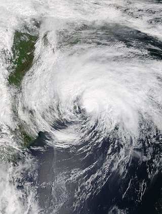
Tropical Storm Arthur was a strong off-season tropical cyclone that impacted the East Coast of the United States in May 2020. The first of thirty-one depressions and thirty different named storms of the extremely active 2020 Atlantic hurricane season, Arthur marked the record sixth consecutive year in the Atlantic basin with a tropical cyclone forming before June. It was one of two off-season storms in the season, alongside short-lived Tropical Storm Bertha. Arthur originated from a front that stalled over the Straits of Florida on May 10, which slowly drifted south for two days. The system became a tropical depression on May 16 north of The Bahamas. A day later, the system intensified into a tropical storm and was named Arthur. Arthur gradually intensified while tracking towards the Outer Banks of North Carolina, attaining its peak intensity with maximum 1-minute sustained winds of 60 mph (95 km/h) and a minimum central pressure of 990 mbar (29 inHg) on May 19, before skirting the region and becoming an extratropical cyclone. The cyclone then accelerated towards Bermuda and dissipated on May 21.