
The 1938 New England Hurricane was one of the deadliest and most destructive tropical cyclones to strike the United States. The storm formed near the coast of Africa on September 9, becoming a Category 5 hurricane on the Saffir–Simpson hurricane scale, before making landfall as a Category 3 hurricane on Long Island on Wednesday, September 21. It is estimated that the hurricane killed 682 people, damaged or destroyed more than 57,000 homes, and caused property losses estimated at $306 million. Also, numerous others estimate the real damage between $347 million and almost $410 million. Damaged trees and buildings were still seen in the affected areas as late as 1951. It remains the most powerful and deadliest hurricane to ever strike New York and New England in history, perhaps eclipsed in landfall intensity only by the Great Colonial Hurricane of 1635.

Hurricane Dora was the first tropical cyclone on record to make landfall over the Atlantic coast of North Florida at hurricane intensity. The sixth tropical storm and second hurricane of the 1964 season, Dora developed from a tropical wave near the coast of Senegal on August 28. The depression intensified into Tropical Storm Dora late on August 31. It then curved northwestward and continued to strengthen. By late on September 2, Dora became a Category 1 hurricane. Intensification slowed somewhat, with Dora becoming a Category 2 hurricane on September 4 and then a Category 3 hurricane on next day. Deepening further, the storm briefly peaked as a Category 4 with maximum sustained winds of 130 mph (215 km/h) on September 6. Dora soon weakened to a Category 3 hurricane and then a Category 2 hurricane while curving westward early the following day.

The 1986 Atlantic hurricane season was a very inactive season that produced 10 depressions, 6 named storms, 4 hurricanes, and no major hurricanes. The season officially began on June 1, 1986, and lasted until November 30, 1986. These dates conventionally delimit the period of each year when most tropical cyclones form in the Atlantic basin. During the 1986 season, the first subtropical depression formed in the first week of June, while the last tropical cyclone dissipated at the end of the third week of November. The 1986 season had lower than average activity because of an ongoing El Niño event, and was the least active season in the North Atlantic since the 1983 Atlantic hurricane season. This was also the first season since 1972 to have no major hurricanes.

Hurricane Donna, known in Puerto Rico as Hurricane San Lorenzo, was the strongest hurricane of the 1960 Atlantic hurricane season, and caused severe damage to the Lesser Antilles, the Greater Antilles, and the East Coast of the United States, especially Florida, in August–September. The fifth tropical cyclone, third hurricane, and first major hurricane of the season, Donna developed south of Cape Verde on August 29, spawned by a tropical wave to which 63 deaths from a plane crash in Senegal were attributed. The depression strengthened into Tropical Storm Donna by the following day. Donna moved west-northwestward at roughly 20 mph (32 km/h) and by September 1, it reached hurricane status. Over the next three days, Donna deepened significantly and reached maximum sustained winds of 130 mph (210 km/h) on September 4. Thereafter, it maintained intensity as it struck the Lesser Antilles later that day. On Sint Maarten, the storm left a quarter of the island's population homeless and killed seven people. An additional five deaths were reported in Anguilla, and there were seven other fatalities throughout the Virgin Islands. In Puerto Rico, severe flash flooding led to 107 fatalities, 85 of them in Humacao alone.

Hurricane Allen was an extremely powerful Cape Verde hurricane that affected the Caribbean, eastern and northern Mexico, and South Texas in August 1980. The first named storm and second tropical cyclone of the 1980 Atlantic hurricane season, it was the sixth most intense Atlantic hurricane on record in terms of barometric pressure, behind Hurricane Milton, Hurricane Rita, the 1935 Labor Day hurricane, Hurricane Gilbert and Hurricane Wilma. It was one of the few hurricanes to reach Category 5 status on the Saffir–Simpson Hurricane Scale on three occasions, and spent more time as a Category 5 than all but two other Atlantic hurricanes. Allen is the only hurricane in the recorded history of the Atlantic basin to achieve sustained winds of 190 mph, thus making it the strongest Atlantic hurricane by wind speed. Until Hurricane Patricia in 2015, these were also the highest sustained winds in the Western Hemisphere. Hurricane Allen was also the third strongest tropical cyclone to exist in the Gulf of Mexico, behind the aforementioned Hurricanes Milton and Rita.

Hurricane Gloria was a powerful hurricane that caused significant damage along the east coast of the United States and in Atlantic Canada during the 1985 Atlantic hurricane season. It was the first significant tropical cyclone to strike the northeastern United States since Hurricane Agnes in 1972 and the first major storm to affect New York City and Long Island directly since Hurricane Donna in 1960. Gloria was a Cape Verde hurricane originating from a tropical wave on September 16 in the eastern Atlantic Ocean. After remaining a weak tropical cyclone for several days, Gloria intensified into a hurricane on September 22 north of the Lesser Antilles. During that time, the storm had moved generally westward, although it turned to the northwest due to a weakening of the ridge. Gloria quickly intensified on September 24, and the next day reached peak winds of 145 mph (233 km/h). The hurricane weakened before striking the Outer Banks of North Carolina on September 27. Later that day, Gloria made two subsequent landfalls on Long Island and across the coastline of western Connecticut, before becoming extratropical on September 28 over New England. The remnants moved through Atlantic Canada and went on to impact Western Europe, eventually dissipating on October 4.

Hurricane David was a devastating Atlantic hurricane which caused massive loss of life in the Dominican Republic in August 1979, and was the most intense hurricane to make landfall in the country in recorded history. A long-lived Cape Verde hurricane, David was the fourth named storm, second hurricane, and first major hurricane of the 1979 Atlantic hurricane season.

Hurricane Bertha was an intense and early-forming major hurricane that affected areas from the Leeward Islands to the United States in July of the 1996 Atlantic hurricane season. The second named storm, first hurricane, and first major hurricane during the season, Bertha originated from a tropical wave that moved off the coast of Africa in early July. Steadily organizing while moving generally towards the west, the disturbance was designated as a tropical depression at 0000 UTC on July 5, and was further upgraded to a tropical storm by 1200 UTC later that day. Over the next few days, continued intensification occurred, and Bertha became a Category 1 hurricane on the Saffir-Simpson hurricane scale, the first hurricane of the season, prior to moving through the northern Leeward Islands. Late on July 8, a period of rapid intensification began, and at 0600 UTC on July 9, Bertha reached its peak intensity with maximum sustained winds of 115 mph (185 km/h) with a minimum barometric pressure of 960 mbar (28 inHg). Moving around the western periphery of the subtropical ridge, Bertha passed north of the Bahamas as a weakening hurricane before turning towards the north-northeast and undergoing another period of rapid intensification. Late on July 12, Bertha made landfall between Wrightsville Beach and Topsail Beach, North Carolina with winds of 105 mph (169 km/h). Gradual weakening ensued the following day as Bertha moved up the Mid-Atlantic and into New England before becoming an extratropical cyclone on July 14. The storm's remnants persisted for another several days, before dissipating on July 18.

Hurricane Isbell was the final hurricane to affect the United States during the 1964 season. The eleventh tropical storm and sixth hurricane of the season, Isbell developed from a dissipating cold front in the southwestern Caribbean on October 8. The depression initially remained disorganized as it track northwestward, but strengthened into Tropical Storm Isbell on October 13. Re-curving northeastward, Isbell quickly strengthened further and reached hurricane status by later that day. Late on October 13, Isbell made landfall in the Pinar del Río Province of Cuba. The storm continued strengthening and peaked as a Category 3 hurricane on the following day. Isbell moved northeastward and made landfall near Everglades, Florida, late on October 14. After reaching the Atlantic on the following day, the storm began to weaken. Isbell turned northward and continued weakening, before transitioning to an extratropical cyclone while located just offshore eastern North Carolina on October 16.

The 1947 Fort Lauderdale hurricane(Air Weather Service designation: George) was a long-lived and an intense tropical cyclone that affected the Bahamas, southernmost Florida, and the Gulf Coast of the United States in September 1947. The fourth Atlantic tropical cyclone of the year, it formed in the eastern Atlantic Ocean on September 4, becoming a hurricane, the third of the 1947 Atlantic hurricane season, less than a day later. After moving south by west for the next four days, it turned to the northwest and rapidly attained strength beginning on September 9. It reached a peak intensity of 145 mph (233 km/h) on September 15 while approaching the Bahamas. In spite of contemporaneous forecasts that predicted a strike farther north, the storm then turned to the west and poised to strike South Florida, crossing first the northern Bahamas at peak intensity. In the Bahamas, the storm produced a large storm surge and heavy damage, but with no reported fatalities.

Hurricane Dennis caused flooding in North Carolina and the Mid-Atlantic states in early September 1999, which would later be compounded by Hurricane Floyd. The fifth tropical cyclone of the season, Dennis developed from a tropical wave to the north of Puerto Rico on August 24. Originally a tropical depression, the system moved west-northwestward and strengthened into a tropical storm despite unfavorable wind shear. The storm became a hurricane by August 26. After striking the Abaco Islands, conditions improved, allowing for Dennis to strengthen into a Category 2 on the Saffir–Simpson scale by August 28. Around this time, Dennis began to move parallel to the Southeastern United States. Early on August 30, the storm peaked with winds of 105 mph (165 km/h). By the following day, steering currents collapsed and the storm interacted with a cold front, causing Dennis to move erratically offshore North Carolina. Wind shear and cold air associated with the front weakened Dennis to a tropical storm on September 1 and removed some of its tropical characteristics. Eventually, warmer ocean temperatures caused some re-strengthening. By September 4, Dennis turned northwestward and made landfall in Cape Lookout, North Carolina, as a strong tropical storm. The storm slowly weakened inland, before transitioning into an extratropical cyclone over western New York on September 7.
The 1999 Blayais Nuclear Power Plant flood was a flood that took place on the evening of December 27, 1999. It was caused when a combination of the tide and high winds from the extratropical storm Martin led to overwhelming of the seawalls of the Blayais Nuclear Power Plant in France. The event resulted in the loss of the plant's off-site power supply and knocked out several safety-related systems, resulting in a Level 2 event on the International Nuclear Event Scale. The incident illustrated the potential for flooding to damage multiple items of equipment throughout a plant, weaknesses in safety measures, systems and procedures, and resulted in fundamental changes to the evaluation of flood risk at nuclear power plants and in the precautions taken. It was in some sense a forerunner of the 2011 Fukushima I nuclear accidents in Japan, but did not trigger the worldwide protection work on low-lying plants that the latter would.
A coastal flood warning is an hazardous weather statement issued by the Weather Forecast Offices of the National Weather Service in the United States which indicates coastal flooding is either imminent or occurring along the coast of the Atlantic Ocean, Pacific Ocean, Arctic Ocean, or the Gulf of Mexico. The flooding must be due to water being forced from the nearby body of water onto the land, and not from rainfall. Nor'easters, hurricanes, tropical storms, and thunderstorms can all lead to the issuance of a coastal flood warning.
A coastal flood advisory is issued by the National Weather Service of the United States when coastal flooding along the coast of the Atlantic Ocean, Pacific Ocean, Arctic Ocean, or the Gulf of Mexico is occurring or imminent, but does not pose a serious threat to lives or property, but rather will simply pose a nuisance to people in the affected area. The flooding must be due to water being forced from the nearby body of water onto land, and not from rainfall. Nor'easters, hurricanes, tropical storms, and thunderstorms can all lead to the issuance of a coastal flood advisory.
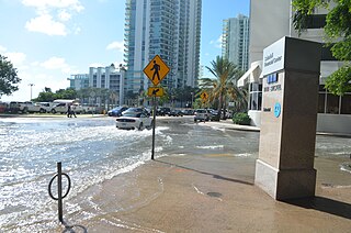
Tidal flooding, also known as sunny day flooding or nuisance flooding, is the temporary inundation of low-lying areas, especially streets, during exceptionally high tide events, such as at full and new moons. The highest tides of the year may be known as the king tide, with the month varying by location. These kinds of floods tend not to be a high risk to property or human safety, but further stress coastal infrastructure in low lying areas.

The 2016 Kaikōura earthquake was a 7.8 earthquake in the South Island of New Zealand that occurred two minutes after midnight on 14 November 2016 NZDT. Ruptures occurred on multiple faults and the earthquake has been described as the "most complex earthquake ever studied". It has been subsequently modelled as having a megathrust component set off by an adjacent rupture on the Humps Fault. It was the second largest earthquake in New Zealand since European settlement.

Hurricane Irma was the costliest tropical cyclone in the history of the U.S. state of Florida, before being surpassed by Hurricane Ian in 2022. Irma developed from a tropical wave near the Cape Verde Islands on August 30, 2017. The storm quickly became a hurricane on August 31 and then a major hurricane shortly thereafter, but would oscillate in intensity over the next few days. By September 4, Irma resumed strengthening, and became a powerful Category 5 hurricane on the following day. The cyclone then struck Saint Maarten and the British Virgin Islands on September 6 and later crossed Little Inagua in the Bahamas on September 8. Irma briefly weakened to a Category 4 hurricane, but re-intensified into a Category 5 hurricane before making landfall in the Sabana-Camagüey Archipelago of Cuba. After falling to Category 3 status due to land interaction, the storm re-strengthened into a Category 4 hurricane in the Straits of Florida. Irma struck Florida twice on September 10 – the first as a Category 4 at Cudjoe Key and the second on Marco Island as a Category 3. The hurricane weakened significantly over Florida, and was reduced to a tropical storm, before exiting the state into Georgia on September 11.