
A levee, dike, dyke, embankment, floodbank, or stop bank is a structure used to keep the course of rivers from changing and to protect against flooding of the area adjoining the river or coast. It is usually earthen and often runs parallel to the course of a river in its floodplain or along low-lying coastlines.

A flood is an overflow of water that submerges land that is usually dry. In the sense of "flowing water", the word may also be applied to the inflow of the tide. Floods are of significant concern in agriculture, civil engineering and public health. Human changes to the environment often increase the intensity and frequency of flooding. Examples for human changes are land use changes such as deforestation and removal of wetlands, changes in waterway course or flood controls such as with levees. Global environmental issues also influence causes of floods, namely climate change which causes an intensification of the water cycle and sea level rise. For example, climate change makes extreme weather events more frequent and stronger. This leads to more intense floods and increased flood risk.

A floodplain or flood plain or bottomlands is an area of land adjacent to a river. Floodplains stretch from the banks of a river channel to the base of the enclosing valley, and experience flooding during periods of high discharge. The soils usually consist of clays, silts, sands, and gravels deposited during floods.
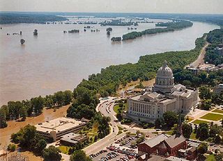
The Great Flood of 1993 was a flood that occurred in the Midwestern United States, along the Mississippi and Missouri rivers and their tributaries, from April to October 1993.

A revetment in stream restoration, river engineering or coastal engineering is a facing of impact-resistant material applied to a bank or wall in order to absorb the energy of incoming water and protect it from erosion. River or coastal revetments are usually built to preserve the existing uses of the shoreline and to protect the slope.
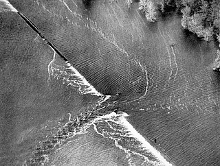
A levee breach or levee failure is a situation where a levee fails or is intentionally breached, causing the previously contained water to flood the land behind the levee.
From 1890 through 2006, the Orleans Levee Board (OLB) was the body of commissioners that oversaw the Orleans Levee District (OLD) which supervised the levee and floodwall system in Orleans Parish, Louisiana The role of the OLB has changed over time. Prior to Hurricane Betsy in 1965, the OLB developed land and sold it to raise money to build and improve flood protection levees. After Betsy, Congress passed the Flood Control Act of 1965 which directed the Army Corps of Engineers to design and build the hurricane flood protection system enveloping New Orleans. Owing to the 1965 legislation, the OLB's duties were now limited to collecting the 30% cost share for project design and construction, and to maintaining and operating completed flood protection structures.

Though Hurricane Katrina did not deal the city of New Orleans a direct hit on August 29, 2005, the associated storm surge precipitated catastrophic failures of the levees and flood walls. The Mississippi River Gulf Outlet ("MR-GO") breached its levees in approximately 15 places. The major levee breaches in the city include the 17th Street Canal levee, the London Avenue Canal, and the wide, navigable Industrial Canal, which left approximately 80% of the city flooded.

A coupure is a means of closing an opening in a wall, floodwall or levee (dike). The word comes from the French verb couper which means "to cut". In historic times a coupure was a location where a breach in the city walls or the walls of a fortress was closed. In more modern times a coupure is a way of allowing traffic to pass a flood protection structure.

On Monday, August 29, 2005, there were over 50 failures of the levees and flood walls protecting New Orleans, Louisiana, and its suburbs following passage of Hurricane Katrina. The failures caused flooding in 80% of New Orleans and all of St. Bernard Parish. In New Orleans alone, 134,000 housing units — 70% of all occupied units — suffered damage from Hurricane Katrina and the subsequent flooding.

A flood barrier, surge barrier or storm surge barrier is a specific type of floodgate, designed to prevent a storm surge or spring tide from flooding the protected area behind the barrier. A surge barrier is almost always part of a larger flood protection system consisting of floodwalls, levees, and other constructions and natural geographical features. Flood barrier may also refer to barriers placed around or at individual buildings to keep floodwaters from entering the buildings.
Drainage in New Orleans, Louisiana, has been a major concern since the founding of the city in the early 18th century, remaining an important factor in the history of New Orleans today. The central portion of metropolitan New Orleans is fairly unusual in that it is almost completely surrounded by water: Lake Pontchartrain to the north, Lake Borgne to the east, wetlands to the east and west, and the Mississippi River to the south. Half of the land area between these bodies of water is at or below sea level, and no longer has a natural outlet for flowing surface water. As such, virtually all rainfall occurring within this area must be removed through either evapotranspiration or pumping. Thus, flood threats to metropolitan New Orleans include the Mississippi River, Lake Pontchartrain, canals throughout the city, and natural rainfall. Artificial levees have been built to keep out rising river and lake waters but have had the negative effect of keeping rainfall in, and have failed on numerous occasions.

Franklinton is a neighborhood in Columbus, Ohio, just west of its downtown. Settled in 1797, Franklinton is the first American settlement in Franklin County, and was the county seat until 1824. As the city of Columbus grew, the city annexed and incorporated the existing settlement in 1859. Franklinton is bordered by the Scioto River on the north and east, Harmon Avenue on the east, Stimmel Road and Greenlawn Avenue on the south, and Interstate 70 on the west. Its main thoroughfare is West Broad Street, one of the city's two main roads.

The Concertainer, known colloquially as the Hesco barrier or Hesco bastion, with HESCO being the brand name of the manufacturer, is a modern gabion primarily used for flood control and military fortifications. It is made of a collapsible wire mesh container and heavy-duty fabric liner and is used as a temporary to semi-permanent levee or blast wall against small-arms fire and/or explosives. It has been used during the war on terror in Iraq and Afghanistan.
Floodplain restoration is the process of fully or partially restoring a river's floodplain to its original conditions before having been affected by the construction of levees (dikes) and the draining of wetlands and marshes.
The Flood Control Act of 1928 authorized the United States Army Corps of Engineers to design and construct projects for the control of floods on the Mississippi River and its tributaries as well as the Sacramento River in California. It was sponsored by Senator Wesley L. Jones (R) of Washington and Representative Frank R. Reid (R) of Illinois, in response to the Great Mississippi Flood of 1927.

Flood control methods are used to reduce or prevent the detrimental effects of flood waters. Flooding can be caused by a mix of both natural processes, such as extreme weather upstream, and human changes to waterbodies and runoff. Flood control methods can be either of the structural type and of the non-structural type. Structural methods hold back floodwaters physically, while non-structural methods do not. Building hard infrastructure to prevent flooding, such as flood walls, is effective at managing flooding. However, best practice within landscape engineering is more and more to rely on soft infrastructure and natural systems, such as marshes and flood plains, for handling the increase in water.

The Big Muddy National Fish and Wildlife Refuge was established in 1994, and has grown to over 16,700 acres (68 km2). Like pearls on a string, these acres are spread out as individual units along the Missouri River between Kansas City and St. Louis. These pearls of habitat benefit floodplain-dependent fish and wildlife species. The Big Muddy Refuge is planning to grow to 60,000 acres (240 km2) by buying land from willing sellers who want to see their properties set aside for the benefit of wildlife and the enjoyment of all.

The Gulf Intracoastal Waterway West Closure Complex is a part of the New Orleans Drainage System; it consists of a navigable floodgate, a pumping station, flood walls, sluice gates, foreshore protection, and an earthen levee. The complex was designed to reduce risk for residences and businesses in the project area from a storm surge associated with a tropical event, with an intensity that has a one percent chance of occurring in any given year. This project was operated for the first time on August 29, 2012, in response to Hurricane Isaac.

The Great Flood of 1913 severely affected Columbus, Ohio. The area most affected was Franklinton, also known as the Bottoms, for its low elevation near the Scioto River. Among many infrastructure projects, a 7.2-mile floodwall was built from 1993 to 2004 to protect most of Franklinton from flooding.


