Template:Infobox weather event/NWS category 5
Satellite image of Hurricane Carla on September 10. | |
Meteorological history | |
---|---|
Formed | September 3,1961 |
Extratropical | September 13,1961 |
Dissipated | September 17,1961 |
Overall effects | |
Fatalities | 43 direct |
Damage | $326 million (1961 USD) |
Areas affected | Yucatán Peninsula,Texas,Central United States,Great Lakes region,Canada,Greenland |
IBTrACS | |
Part of the 1961 Atlantic hurricane season |
Hurricane Carla was the most intense tropical cyclone landfall in Texas in the 20th century. [1] The third named storm of the 1961 Atlantic hurricane season,Carla developed from an area of squally weather in the southwestern Caribbean Sea on September 3. [1] As a tropical depression,it strengthened while heading northwest. The system was upgraded to a tropical storm on September 5 and reached hurricane intensity on September 6. On September 7,Carla entered the Gulf of Mexico,passing northeast of the Yucatán Peninsula. On the morning of September 11,Carla became a category 4 hurricane when winds reached 130 mph (282 km/h). [2] Carla made landfall at 2 p.m. on September 11 near Port O'Connor,Texas as a category 4 hurricane with an intensity of 145 mph (125 knots). Traveling inland,the storm was reduced to a tropical storm on September 12 and transitioned into an extratropical cyclone on September 13,while centered over southern Oklahoma. Carla's remnants reached the Labrador Sea,Canada and dissipated on September 17, 1961.
While crossing the Yucatán Channel,the outer bands of Carla brought high winds and local flooding in western Cuba and the Yucatán Peninsula. In Texas,wind gusts as high as 170 mph (270 km/h) were observed in Port Lavaca. Tornadoes spawned in the state,including an F4 tornado near Galveston,Texas,resulting in 60 buildings destroyed,eight deaths and 200 injuries.
Throughout the state,Carla destroyed 1,915 homes,568 farm buildings,and 415 other buildings. Additionally,50,723 homes,5,620 farm buildings,and 10,487 other buildings suffered damage. There were 34 fatalities and at least $300 million in losses in Texas. Several tornadoes also touched down in Louisiana,causing the destruction of 140 homes and 11 farms and other buildings,and major damage to 231 additional homes and 11 farm and other buildings. Minor to moderate damage was also reported to 748 homes and 75 farms and other buildings. Six deaths and $25 million in losses in Louisiana were attributed to Carla. Heavy rainfall occurred in several other states,especially in Kansas,where flash flooding severely damaged crops and drowned five people. Overall,Carla resulted in $325.74 million in losses and 43 fatalities.
As early as September 1, a tropical disturbance – an area of convective activity – was observed tracking westward across the Caribbean Sea within the Intertropical Convergence Zone (ITCZ). Around that time, an anticyclone was situated over the western Caribbean Sea at the upper-tropospheric levels. Surface charts indicate that a low-level circulation was developing early on September 3. [3] Thus, it is estimated that a tropical depression – a tropical cyclone with sustained winds with winds of less than 39 mph (63 km/h ) – developed about 175 miles (282 km) northwest of Barranquilla, Colombia at 1200 UTC. [4] Initially, the center of circulation remained difficult to locate on surface charts due to lack of data. At San Andrés, winds shifted west at about 12 mph (19 km/h), while barometric pressures dropped to 1,007 mbar (29.7 inHg ). The Weather Bureau Office in Miami, Florida issued its first bulletin at 1600 UTC on September 4, while the depression was centered about 250 miles (400 km) east-southeast of Cabo Gracias a Dios, Nicaragua. [3]
It is estimated that sustained winds reached 45 mph (72 km/h) at 1200 UTC on September 5, [5] thus the depression strengthened into a tropical storm and was named Carla, while located just northeast of Cabo Gracias a Dios. [4] A reconnaissance aircraft flight reported that Carla was continuing to intensify, with surface winds of 50 mph (80 km/h). Radars reported an unusually large tropical cyclone, with convective bands extending about 520 miles (840 km) outward from the center. Around 0000 UTC on September 6, Carla passed near Swan Island, which reported a barometric pressure of about 995 mbar (29.4 inHg) and wind gusts of 60 mph (97 km/h) from the southwest. [5] Based on observations obtained by a reconnaissance aircraft at 1100 UTC on September 6 – namely a barometric pressure of 982 mbar (29.0 inHg) – a bulletin issued by the Weather Bureau an hour later indicated that the storm had "probably reached hurricane intensity". [6] According to post-season analysis, Carla reached hurricane status at that time. [4]
Shortly after becoming a hurricane on September 6, Carla curved northward in the northwestern Caribbean Sea. At 1200 UTC on September 7, the storm intensified into a Category 2 hurricane while located east-northeast of Cozumel, Quintana Roo, Mexico (actual use of the Saffir-Simpson Hurricane Wind Scale, which was developed in 1971, was not in effect). Shortly thereafter, Carla crossed the Yucatán Channel and entered the Gulf of Mexico. A strong high-pressure area forced Carla to resume its original northwesterly course. Early on September 8, the storm strengthened into a Category 3 hurricane while located just north of the Yucatán Peninsula. Thus, Carla was the third major hurricane of the season. Carla was upgraded to a Category 4 hurricane early on September 10, while approaching the Gulf Coast of the United States. Operationally, at 0000 UTC on September 11, Carla strengthened into a Category 5 hurricane while located in the northwestern Gulf of Mexico. Six hours later, the storm reached its maximum sustained wind speed of 175 mph (282 km/h). [4] However, a 2018 reanalysis concluded that Carla did not reach Category 5 intensity, and in fact only had maximum sustained winds of 145 mph (233 km/h), and this has been officially incorporated into HURDAT. [7]
Late on September 11, Carla reached its minimum barometric pressure of 931 mbar (27.5 inHg). Later that day, the storm struck Matagorda Island, Texas (seven miles south of Port O'Connor) with winds of 145 mph (233 km/h). Carla rapidly weakened inland, and degenerated to a Category 2 hurricane on September 12, while passing just east of Port Lavaca. Six hours later, the storm was downgraded to a Category 1 hurricane near Shiner, shortly before being downgraded to a tropical storm between Taylor and Coupland. Beginning late on September 12, the storm curved just east of due north. After reaching Oklahoma early on September 13, Carla transitioned into an extratropical cyclone while located over rural Johnston County. The extratropical remnants of Carla moved rapidly northeastward and brought heavy rainfall to some areas of the Great Plains and Midwestern United States. By September 14, it entered Canada near Sault Ste. Marie, Ontario. It then continued swiftly northeastward across Ontario, Quebec, and Labrador, before the remnants dissipated over the Labrador Sea on September 17. [4]
Occurring a year after Hurricane Donna, officials in the Florida Keys took precautions to brace for potential impact from the storm. The United States Navy flew their planes out of Key West, while Coast Guardsmen evacuated Alligator Reef Light, American Shoal Light, and Sombrero Key Light. Ships docked at Key West sailed out to sea to ride out the squalls. On the morning of September 7, a hurricane watch was issued from the entire coast of Louisiana eastward to Apalachicola, Florida. [8] On September 8, a hurricane watch was issued along the southwest coast of the state from Vermilion Bay westward. [9] It was later extended westward to include the entire coast of Texas, and eastward to Apalachicola, Florida. [10] A portion of the hurricane watch from Aransas Pass, Texas to Grand Isle, Louisiana was upgraded to a hurricane warning at 1600 UTC on September 9. [11] An estimated 500,000 people fled the coasts of Texas and Louisiana, making it the largest evacuation in the history of the United States, at the time. [12] Further, at least half of those people were from Texas. In small towns along the coast of Texas, 90–100% of their populations evacuated, while 20% of people left the larger cities. Many in Galveston stayed due to protection from the Galveston Seawall. [13]
Carla spawned 21 tornadoes, the largest hurricane-related tornado outbreak on record at the time. [14] However, it was overwhelmingly surpassed by Hurricane Beulah in 1967, which spawned at least 120 tornadoes. [15] Throughout its path, 43 fatalities and about $325.74 million in damage were attributed to Carla. Most of the impact occurred in Texas, where the storm made landfall as a large and strong Category 4 hurricane. [16] [17] [18]
Abnormally high tides and storm surge was reported along the coast of Texas, reaching at least 10 feet (3.0 m) above mean sea level at many coastal areas between Sabine Pass and Port Aransas. The highest tide reported was 18.5 feet (5.6 m) at Port Lavaca, with large wave heights including 12.6 feet (3.8 m) in Matagorda, 10.9 feet (3.3 m) in Port Aransas, 10.8 feet (3.3 m) in Freeport, 10.1 feet (3.1 m) in Texas City, and 10 feet (3.0 m) in Galveston and Sabine. Because the storm was a Category 4 hurricane at landfall, Carla produced strong winds, especially near its path. The strongest sustained winds include 115 mph (185 km/h) in Matagorda, 110 mph (180 km/h) in Victoria, and 88 mph (142 km/h). Additionally, the highest wind gust observations include 175 mph (282 km/h) in Port Lavaca, 160 mph (260 km/h) in Matagorda, and 150 mph (240 km/h) in Aransas Pass, Austwell, Edna, Port Aransas, and Victoria. Carla produced heavy rainfall in Texas, peaking at 17.48 inches (444 mm) in Bay City. Other significant precipitation totals include 16.49 inches (419 mm) at Scholes International Airport at Galveston, 14.94 inches (379 mm) in Downtown Galveston, 13.05 inches (331 mm) in Wharton, 12.55 inches (319 mm) in Liberty, 12.47 inches (317 mm) in Dickinson, 11.81 inches (300 mm) in Flatonia, 10.59 inches (269 mm) in Columbus, 8.75 inches (222 mm) in Hallettsville, and 8.9 inches (230 mm) in Smithville. [13]
The most significant property damage occurred between Port Arthur and Corpus Christi. Port O'Connor, lying nearest to the location of Carla's landfall, was virtually destroyed. In Columbus, the "Ranch Drive-In" theater is destroyed by the storm and was never reopened after 6 years of operation. In Victoria, the highest sustained wind speed was 110 mph (180 km/h), while gusts reached 150 mph (240 km/h). About 4,260 homes were damaged, with around 500 severely damaged or destroyed. 43 businesses and 26 public buildings were also significantly impacted. Damage in the city of Victoria reached $10 million. [19] Of the 21 tornadoes spawned by Carla, eight of them in Texas caused significant impact. On September 11, an F2 tornado near Bay City destroyed two radio towers and damaged several buildings. An F3 tornado injured three people and caused the destruction of one house and impacted three others in Jacksonville, resulting in $25,000 in damage. Another F3 tornado in Channelview, located east of Houston, injured 22 people, destroyed 18 homes and six commercial buildings, damaged 40 additional homes, and caused $200,000 in damage. In the early morning hours of September 12, a violent F4 tornado moved across Galveston Island along a 1-mile long, 100-yard-wide path (it crossed into Galveston Bay as well), severely damaging 200 buildings, of which 60-75 were destroyed, [20] and causing eight deaths and 200 injuries. This was the first of only two known violent tornadoes ever spawned by a hurricane with the other one happening during Hurricane Hilda in 1964. A few hours later, an F3 tornado in the area destroyed six houses and extensive, but lesser, damage. In Hardin, another F3 tornado damaged six homes. Several structures sustained impact during yet another F3 tornado in Fulbright. The final tornado occurred during the late afternoon hours of September 13 in Latex. It caused F2 damage, two injuries, and resulted in $2,500 in losses after damaging two houses and three garages. [21]
Then little-known newsman Dan Rather reported live from the weather bureau building in Galveston [22] [23] during the storm, live on-site storm coverage that would be imitated by later reporters. This marked the first live television broadcast of a hurricane. Rather also alerted the public of the size of Carla in a way that "literally changed the way the world sees hurricanes", according to a fellow reporter. Broadcasting live at the Weather Bureau Office in Galveston, Rather asked a meteorologist to outline the Gulf of Mexico on a transparent sheet of plastic. He then held the map over the black and white radar screen, which put the size of Carla into perspective, saying that Carla was the size of the Gulf of Mexico. CBS was so impressed with Rather's work that he was offered the position of correspondent. [24] Throughout Texas, Carla destroyed 1,915 homes, 568 farm buildings, and 415 other buildings. Additionally, 50,723 homes, 5,620 farm buildings, and 10,487 other buildings suffered damage. There were 460 injuries according to the American Red Cross, though the Monthly Weather Review listed a slightly higher number, 465. The storm caused 34 fatalities in Texas. Causes of death include 20 people drowning, eight from tornadoes, four electrocutions, and one heart attack. [25] Overall, damage in the state was "conservatively" estimated at $300 million. [16] A breakdown of damage indicates $200 million incurred to property and $100 million to crops, mostly from unharvested rice and lesser impact to cotton and citrus. [16]
In southeastern Louisiana, abnormally high tides lashed the coast, though no beach erosion was reported. Rainfall was heavy, peaking at 13.9 inches (350 mm) in Many. Other observed precipitation totals include 5.6 inches (140 mm) in Baton Rouge, 5.57 inches (141 mm) in Morgan City, 4.25 inches (108 mm) in Shreveport, 3.16 inches (80 mm) in New Orleans, 2.25 inches (57 mm) in Lafayette, 2.19 inches (56 mm) in Alexandria, 2.1 inches (53 mm) in Jonesboro and West Monroe, and 1.37 inches (35 mm) in Lake Charles. [26] In the western portions of Louisiana, sustained winds peaked at 44 mph (71 km/h) and gusts reached 55 mph (89 km/h). Only minor damage occurred, limited to roofs, glass, and downed tree limbs. Winds caused a local river to reach 1 foot (0.30 m) above flood stage. [27] The 11 tornadoes spawned by Carla in Louisiana destroyed 140 homes and 11 farm and other buildings, while causing major damage to 231 additional homes and 11 farm and other buildings. Additionally, 748 homes and 75 farm and other buildings suffered minor to moderate damage. Six fatalities and 199 injuries occurred, mostly related to the tornadoes. Damage in Louisiana totaled to about $25 million. A breakdown of losses include $6 million to agriculture, $5 million to buildings, $4 million to boats and beach property, $3 million to roads and bridges, $5 million to oil platforms just offshore, and $2 million in miscellaneous damage. [18]
Carla and its remnants brought heavy rainfall and strong winds to portions of Oklahoma. About 2–8 inches (51–203 mm) of rain fell in Grant, Tillman, Washita Counties. Heavier amounts of at least 5 inches (130 mm) fell in Atoka and Pushmataha County. [17] Precipitation in the state peaked at 7.68 inches (195 mm) in Kingfisher. [28] More than 140 city blocks were flooded with up to 6 feet (1.8 m) in residential areas of Kingfisher and up to 3 feet (0.91 m) in business areas. 225 homes and buildings in the city suffered water damage. Throughout the state, damage in other areas included 90 homes and buildings in Tulsa, 50 homes each in El Reno and Oklahoma City, and 10 homes in Pawnee. Additionally, water inundation washed out several bridges and highways in northeastern parts of the state, leaving roads impassable. Sustained winds between 30 and 55 mph (48 and 89 km/h) and gusts up to 70 mph (110 km/h) were recorded in Oklahoma. Winds injured two people due to airborne debris. Winds and rain combined severely disrupted electrical and telephone services and caused $670,000 in damage, with $600,000 to property and $70,000 to crops. [17]
The storm dropped precipitation amounts of 7 inches (180 mm) throughout northwestern Illinois, with a peak of 8.18 inches (208 mm) in Mount Carroll. Thus, Carla is the second-wettest tropical cyclone in Illinois, behind only Hurricane Audrey in 1957. [28] Additionally, up to 6.29 inches (160 mm) fell in 24 hours. Severe local flooding occurred, especially in the northern portions of the state. Heavy property and agricultural damage occurred. Streets and basements were reported to have flooded, while bridge approaches and a few small bridges were washed out. Precipitation of 2.5–3.5 inches (64–89 mm) in Chicago flooded about 60 viaducts and 1,000 basements. After the Chicago River rose 5 feet (1.5 m), the lock gate to Lake Michigan was opened to release excess water. However, the abrupt onrush of water resulted in about $75,000 in damage to boats at Wilmette Harbor. [16] [18]
Winds in Key West reached 30 mph (48 km/h), while much of Florida reported rainfall from the outer bands of Carla. [29] In Kansas, 4 to 7 inches (100 to 180 mm) of rain in only 6 hours caused flash flooding. With a peak amount of 8.52 inches (216 mm) in Haddam, Carla was the rainiest tropical cyclone in Kansas, until being surpassed by Hurricane Paine in 1986 as well as Tropical Storm Frances in 1998. [28] Severe crop damage occurred, especially in areas of Chautauqua and Shawnee Counties and to the south of the Kansas River. Many highways were left impassable due to water inundation. A family of 4 drowned after their car was swept off a road near Waverly. A fifth fatality occurred after a car with one occupant was swept into a tributary of the Marmaton River near Fort Scott. The storm persistently produced winds of 35 to 50 mph (56 to 80 km/h), causing further agricultural damage. [16]
In Nebraska, rainfall peaked at 5.68 inches (144 mm) in Hubbrell, making Carla the rainiest tropical cyclone in the state. [28] Heavy precipitation also fell in Missouri, especially in Brookfield, Lee's Summit, and Pleasant Hill. The maximum rainfall total in Missouri was 9.34 inches (237 mm) in Concordia. [28] One fatality was reported in Missouri, though the cause of death is unknown. Rainfall in Iowa peaked at 9.03 inches (229 mm) near Chariton, making Carla the rainiest tropical cyclone in the state. [28] Up to 8 inches (200 mm) of rain fell in a 12-hour period in the Lower Peninsula of Michigan, mostly between Cheboygan and Grand Rapids. [16] However, the Weather Prediction Center indicated precipitation amounts of 6.07 inches (154 mm) in Boyne Falls. Regardless, Carla is the wettest tropical cyclone in the history of Michigan. [28] Despite, the rainfall, flooding in Michigan was relatively minimal, limited to a washed out dam in Traverse City. [16] Precipitation in Wisconsin reached 7.58 inches (193 mm) in Brodhead, causing Carla to rank as the wettest tropical cyclone in the state. [28] Precipitation peaks in other states include 4.44 inches (113 mm) in Alabama, 5.48 inches (139 mm) in Arkansas, 6.37 inches (162 mm) in Mississippi, [30] and 3.6 inches (91 mm) in Indiana. [28]
In Cuba, broadcasts reported severe flooding near Pinar del Río, and in Los Colomas and Punta de Cartas. Offshore Honduras on Swan Island, a rainfall amount of 3.89 inches (99 mm) was reported along with wind gusts up to 60 mph (97 km/h). The remnants of Carla brought tropical storm force winds to some areas of Canada. In Ontario, gusty winds caused power outages in the Clarkson–Port Credit area. Electrical services were are disrupted in New Brunswick, due to winds up to 80 mph (130 km/h) in Saint John. Winds of 57 mph (92 km/h) lashed Halifax in Nova Scotia, thus the Halifax Public Gardens closed for threat of falling trees and branches. [31]
Shortly after the storm, Vice President Lyndon B. Johnson, a lifelong resident of Texas, toured the devastation in the state and met with officials from 18 different counties, remarking that "as always, Texans are arising to a challenge... We have suffered hurricane, tornado, and floods, but we in Texas are a bold and brave people." [32] After his report to President John F. Kennedy and Congress, $55 million was approved in aid for Texas, though Kennedy later requested an additional $65 million. [33] President Kennedy issued a disaster declaration for Texas, allowing all jurisdictions in the state to apply for public assistance. [34] The president also declared 6 parishes in Louisiana a disaster area. [33] Helicopters deployed 88 United States Marines to Galveston to patrol devastated areas. A United States Navy task force composed of medical and construction work teams was also sent to the area. Members of the United States National Guard assisted refugees in returning to their homes and worked to prevent looting. [35]
Owing to the hurricane's intensity and destruction, the name Carla was retired after his season, and will never again be used for an Atlantic hurricane. [36] The name was replaced with Carol for the 1965 season. [37]
Hurricane Alicia was a small but powerful tropical cyclone that caused significant destruction in the Greater Houston area of Southeast Texas in August 1983. Although Alicia was a relatively small hurricane, its track over the rapidly growing metropolitan area contributed to its $3 billion damage toll, making it the costliest Atlantic hurricane at the time. Alicia spawned from a disturbance that originated from the tail-end of a cold front over the northern Gulf of Mexico in mid-August 1983. The cyclone was named on August 14 when it became a tropical storm, and the combination of weak steering currents and a conducive environment allowed Alicia to quickly intensify as it drifted slowly westward. On August 17, Alicia became a hurricane and continued to strengthen, topping out as a Category 3 major hurricane as it made landfall on the southwestern end of Galveston Island. Alicia's eye passed just west of Downtown Houston as the system accelerated northwestwards across East Texas; Alicia eventually weakened into a remnant area of low pressure over Oklahoma on August 20 before they were last noted on August 21 over eastern Nebraska.
Tropical Storm Allison was a tropical storm that devastated southeast Texas in June of the 2001 Atlantic hurricane season. An arguable example of the "brown ocean effect", Allison lasted unusually long for a June storm, remaining tropical or subtropical for 16 days, most of which was when the storm was over land dumping torrential rainfall. The storm developed from a tropical wave in the northern Gulf of Mexico on June 4, 2001, and struck the upper Texas coast shortly thereafter. It drifted northward through the state, turned back to the south, and re-entered the Gulf of Mexico. The storm continued to the east-northeast, made landfall on Louisiana, then moved across the southeast United States and Mid-Atlantic. Allison was the first storm since Tropical Storm Frances in 1998 to strike the northern Texas coastline.
The 1958 Atlantic hurricane season included every tropical cyclone either affecting or threatening land. There were ten named storms as well as one pre-season tropical storm. Seven of the storms became hurricanes, including five that were major hurricanes, or the equivalent of a Category 3 on the Saffir-Simpson scale. The strongest storm was Hurricane Helene, which became a strong Category 4 hurricane with 150 mph (240 km/h) winds and a barometric pressure of 930 millibars (27 inHg) while just offshore the southeastern United States.
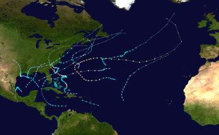
The 1959 Atlantic hurricane season featured near normal tropical cyclone activity overall. The season officially began on June 15, 1959 and lasted until November 15, 1959. These dates historically described the period in each year when most tropical cyclogenesis occurs in the Atlantic basin. However, the formation of a tropical cyclone is possible at any time of the year, as shown in 1959, by the formation of Tropical Storm Arlene on May 28. Arlene struck Louisiana and brought minor flooding to the Gulf Coast of the United States. The next tropical storm, Beulah, formed in the western Gulf of Mexico and brought negligible impact to Mexico and Texas. Later in June, an unnamed hurricane, caused minor damage in Florida, and then devastated parts of Maritime Canada, resulting in what became known as the Escuminac disaster. Hurricane Cindy brought minor impact to The Carolinas. In late July, Hurricane Debra produced flooding in the state of Texas. Tropical Storm Edith in August and Hurricane Flora in September caused negligible impact on land.
The 1960 Atlantic hurricane season was the least active season since 1952. The season officially began on June 15, and lasted until November 15. These dates conventionally delimit the period of each year when most tropical cyclones form in the Atlantic basin. The first system, an unnamed storm, developed in the Bay of Campeche on June 22. It brought severe local flooding to southeastern Texas and was considered the worst disaster in some towns since a Hurricane in 1945. The unnamed storm moved across the United States for almost a week before dissipating on June 29. In July, Hurricane Abby resulted in minor damage in the Leeward Islands, before impacting a few Central American counties — the remnants of the storm would go on to form Hurricane Celeste in the East Pacific. Later that month, Tropical Storm Brenda caused flooding across much of the East Coast of the United States. The next storm, Hurricane Cleo, caused no known impact, despite its close proximity to land.
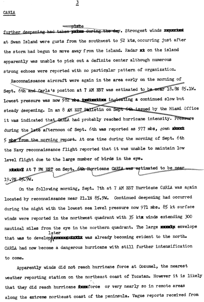
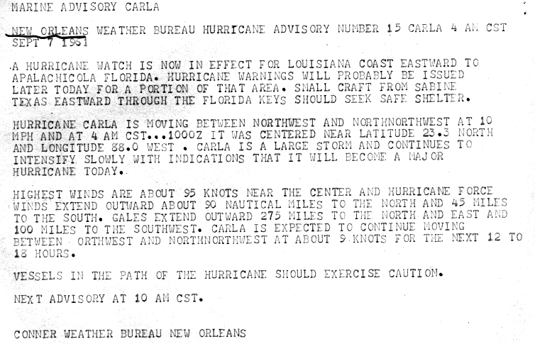
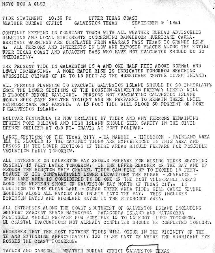
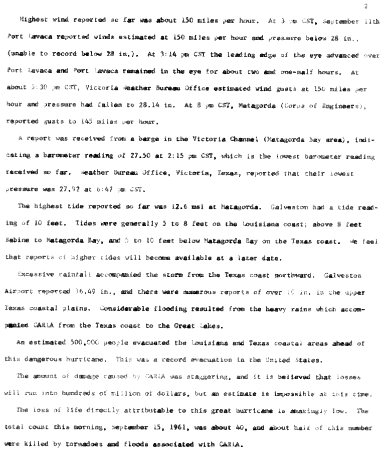
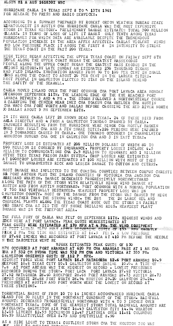
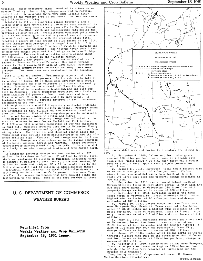
The 1961 Atlantic hurricane season was a very active Atlantic hurricane season, with an accumulated cyclone energy (ACE) total of 189. The season, however, was an average one in terms of named storms. The season featured eight hurricanes and a well above average number of five major hurricanes. It was previously thought that the season had a record-tying seven major hurricanes, before the Atlantic hurricane reanalysis project downgraded two storms in 2019. Two Category 5 hurricanes were seen in 1961, making it one of only seven Atlantic hurricane seasons to feature multiple Category 5 hurricanes in one season. The season started on June 15, and ended on November 15. These dates conventionally delimit the period of each year when most tropical cyclones form in the Atlantic basin. The first system, an operationally unclassified tropical depression, formed offshore east Central Florida on June 10, but dissipated a few days later. Next, Hurricane Anna developed in the eastern Caribbean Sea near the Windward Islands on July 20. It brought minor damage to the islands, as well as wind and flood impacts to Central America after striking Belize as a hurricane. Anna caused one death and about $300,000 (1961 USD) in damage. Activity went dormant for nearly a month and a half, until Hurricane Betsy developed on September 2. Betsy peaked as a Category 4 hurricane, but remained at sea and caused no impact.
Hurricane Hilda was an intense tropical cyclone that ravaged areas of the United States Gulf Coast, particularly Louisiana. In addition to its damage inland, the hurricane greatly disrupted offshore oil production, and at its time was the costliest tropical cyclone for Louisiana's offshore oil production. Due in part to flights made by the National Hurricane Research Laboratory, Hilda became one of the most well-documented storms meteorologically in the Atlantic. Lasting for seven days as a tropical cyclone, Hilda caused US$126 million in damage and 38 deaths. It was the tenth named storm, sixth hurricane, and the fourth major hurricane of the 1964 Atlantic hurricane season.
Tropical Storm Frances caused extensive flooding in Mexico and Texas in September 1998. The sixth tropical cyclone and sixth named storm of the annual hurricane season, Frances developed from a low pressure area in the Gulf of Mexico on September 8. The cyclone moved northward through the western Gulf of Mexico, making landfall across the central Texas coastline before recurving across the Midwest through southeast Canada and New England. A large tropical cyclone for the Atlantic basin, yet an average sized system by western Pacific standards, the storm produced heavy rains across the Isthmus of Tehuantepec, Texas, western Louisiana and the Great Plains.
Hurricane Chantal was one of three tropical cyclones to make landfall in Texas during the 1989 Atlantic hurricane season. The third named storm and the first hurricane of the season, Chantal slowly developed on July 30 in the southern Gulf of Mexico from a tropical disturbance that was previously within Intertropical Convergence Zone (ITCZ) while near Trinidad and Tobago. While heading north-northwestward, the depression steadily intensified and was upgraded to Tropical Storm Chantal on the following day. Thereafter, Chantal quickly strengthen and became a hurricane on August 1. After intensifying slightly further, Chantal made landfall near High Island, Texas later that day. The storm quickly weakened upon moving inland and fell to tropical storm intensity a few hours after landfall. Early on August 2, Chantal weakened to a tropical depression and dissipated over Oklahoma by August 4.
Hurricane Audrey was one of the deadliest hurricanes in U.S. history, killing at least 416 people as it devastated the southwestern Louisiana coast in 1957. Along with Hurricane Alex in 2010, it was also the strongest June hurricane ever recorded in the Atlantic basin as measured by pressure. The rapidly developing storm struck southwestern Louisiana as an intense Category 3 hurricane, destroying coastal communities with a powerful storm surge that penetrated as far as 20 mi (32 km) inland. The first named storm and hurricane of the 1957 hurricane season, Audrey formed on June 24 from a tropical wave that moved into the Bay of Campeche. Situated within ideal conditions for tropical development, Audrey quickly strengthened, reaching hurricane status a day afterwards. Moving north, it continued to strengthen and accelerate as it approached the United States Gulf Coast. On June 27, the hurricane reached peak sustained winds of 125 mph (205 km/h), making it a major hurricane. At the time, Audrey had a minimum barometric pressure of 946 mbar. The hurricane made landfall with the same intensity between the mouth of the Sabine River and Cameron, Louisiana, later that day, causing unprecedented destruction across the region. Once inland, Audrey weakened and turned extratropical over West Virginia on June 29. Audrey was the first major hurricane to form in the Gulf of Mexico since 1945.
Hurricane Fern was the sixth named storm and fourth hurricane of the 1971 Atlantic hurricane season. It formed from a tropical wave which interacted with a large trough of low pressure to form Fern, as well as Hurricane Ginger, Tropical Storm Heidi, and a system later designated as Tropical Depression Sixteen, which moved into South Carolina. Fern crossed southeastern Louisiana as a tropical depression on September 4 before swinging back out over the Gulf of Mexico. Fern reached hurricane status on September 8, reaching a peak intensity of 90 mph (140 km/h) before making landfall near Freeport, Texas, two days later.
Tropical Storm Chris caused minor flooding along the Gulf Coast of the United States in September 1982. The fifth tropical or subtropical cyclone and third named storm of the 1982 Atlantic hurricane season, Chris developed from a surface low-pressure area in the northern Gulf of Mexico on September 9. Although initially displaying subtropical characteristics, the low pressure area gradually acquired tropical characteristics, and was reclassified as Tropical Depression Four within 24 hours of development. The depression then began to intensify and was upgraded to Tropical Storm Chris on September 10. Thereafter, the storm turned north-north-eastward and strengthened further. On September 11, Chris peaked as a 65 mph (100 km/h) tropical storm. Later that day, it made landfall near Sabine Pass, Port Arthur, Texas. By September 13, Chris dissipated over Arkansas.
Hurricane Humberto was a Category 1 hurricane that formed and intensified faster than any other North Atlantic tropical cyclone on record, before landfall. The eighth named storm and third hurricane of the 2007 Atlantic hurricane season, Humberto developed on September 12, 2007, in the northwestern Gulf of Mexico. The tropical cyclone rapidly strengthened and struck High Island, Texas, with winds of about 90 mph (140 km/h) early on September 13. It steadily weakened after moving ashore, and on September 14, Humberto began dissipating over northwestern Georgia as it interacted with an approaching cold front.
Tropical Storm Felice was a modest tropical cyclone that lightly affected parts of the Gulf Coast of the United States in mid-September 1970. Spawned by an upper-level trough over the Bahamas, the system crossed the Florida Keys and entered the Gulf of Mexico, where it gradually began to strengthen. Felice was a disorganized storm for its entire duration, plagued by dry air, a lack of deep thunderstorm activity, and an ill-defined center of circulation, but nevertheless managed to peak as a high-end tropical storm with winds just below Category 1 hurricane strength. Tracking northwestward, the storm brushed southern Louisiana on September 15 before making landfall northeast of Galveston, Texas, late that same day. Once ashore, Felice quickly deteriorated as it recurved into the central United States. While over southeastern Oklahoma, however, its remnants still closely resembled a formidable tropical cyclone.
Tropical Storm Abby was an exceptionally small tropical cyclone that had minor effects across Southeast Texas in early August 1964. Forming as a tropical depression out of a trough south of Louisiana on August 5, the system moved generally westward. It was not until August 7 that the system began to organize. That day, an eye rapidly formed within the system and it became a tropical storm just 60 mi (95 km) southeast of Galveston, Texas. Soon thereafter, a weather reconnaissance plane reported a barometric pressure of 1000 mbar at the storm's center. Around 18:00 UTC, the newly named Abby attained peak winds of 70 mph (115 km/h). It subsequently made landfall near Matagorda, Texas four hours later. Once onshore gradual weakening ensued, though a brief period of re-organization delayed its dissipation. Abby degenerated into an area of showers on August 8 southwest of San Antonio, Texas.
The 1960 Texas tropical storm brought severe but localized flooding to southeastern Texas in June 1960. The first tropical cyclone and first tropical storm of the 1960 Atlantic hurricane season, this system developed from an area of showers and thunderstorms in the Bay of Campeche on June 22. Initially a tropical depression, it strengthened and was estimated to have reached tropical storm status on June 23. Early on the following day, the storm peaked with winds of 60 mph (97 km/h). Later that day, it made landfall near Corpus Christi, Texas, at the same intensity. The storm weakened slowly and moved across the Central United States, before dissipating over Illinois on June 28.
Hurricane Debra was a destructive tropical cyclone that developed during the 1959 Atlantic hurricane season. The fifth tropical storm and third hurricane of the season, Debra originated from the interaction of a cold-core low and a tropical wave on July 15. The system was designated a tropical depression on July 23 when it was south of Louisiana and meandered westward while it swiftly intensified into a tropical storm along the Gulf Coast of the United States. A turn towards the northwest became evident as it attained Category 1 hurricane status on the Saffir–Simpson Hurricane Scale the following day while it organized into a developed storm. As the hurricane curved northward at a slow forward speed, strength was maintained as it approached the coast of Texas as a minimal hurricane. It came ashore during the evening of July 24 local time between Freeport and Galveston, Texas. It rapidly weakened into a tropical storm and later a depression as it moved inland, and dissipated on July 28 while it turned northwestward. The remnant moisture later sparked upper-level thunderstorms in late July and early August.
{{cite journal}}
: Cite journal requires |journal=
(help)